University of Minnesota
http://www.umn.edu/
612-625-5000
http://www.umn.edu/
612-625-5000
Minnesota Biodiversity Atlas
Bell Museum
Dataset: MIN-Plants
Taxa: Dulichium
Search Criteria: excluding cultivated/captive occurrences
Bell Museum plants | |
 MIN:Plants |  789768[1019665]Smith, Welby 109481985-07-31 United States, Minnesota, Beltrami, S end of Grass Lake, about 2 mi w of Bemidji; SW1/4 NW1/4 section 1, T146N R34W;;146N;34W;1, 47.491413 -94.937918 |
MIN:Plants |  794979[1019680]Sanford, J. s.n.1948-08-00 United States, Minnesota, Clearwater, Itasca State Park;Itasca State Park;143N;36W;, 47.19557 -95.233216 |
MIN:Plants |  797550[1019733]Cholewa, A.; et al. 15241988-08-06 United States, Minnesota, Aitkin, Ca 4 mi s of Palisade, nw shore of Jenkins Lake. se1/4 of se1/4 of section.;;048N;25W;10, 46.6533333 -93.4836111 |
MIN:Plants |  797557[1019732]Cholewa, A.; Engels, A. 15091988-08-05 United States, Minnesota, Aitkin, Aitkin Co. Savanna Portage State Park; W of Loon Lake; T50N R23W S13 nw1/4 of ne1/4;Savanna Portage State Park;050N;23W;13, 46.817098 -93.200656 |
MIN:Plants | 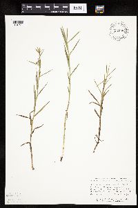 801098[1019734]Smith, Welby 109661985-08-01 United States, Minnesota, Beltrami, In School Lake on the n side of State Hwy 8, about 8 mi E-SE of Bemidji; SW1/4 SW1/4 section 16, T146N R32W;;146N;32W;16, 47.461201 -94.745341 |
MIN:Plants | 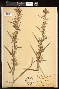 81471[1102481]Sandberg, John 5761889-07-00 United States, Minnesota, Hennepin, [no further data];;;;, 45 -93.47 |
MIN:Plants | 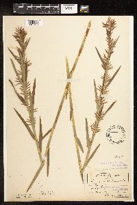 81472[1102482]Sandberg, John s.n.1889-07-00 United States, Minnesota, Hennepin, [no further data];;;;, 45 -93.47 |
MIN:Plants | 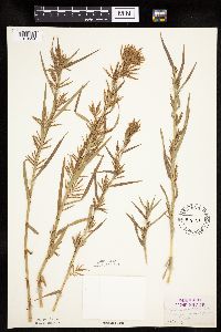 81473[1019654]Herrick, C. 105-91898-07-23 United States, Minnesota, Hennepin, Minneapolis.;;N;;, 44.979965 -93.263836 |
MIN:Plants |  81474[1019664]Rosendahl, C.; Butters, F. 36271918-07-17 United States, Minnesota, Anoka, Moore Lake;;030N;24W;, 45.080985 -93.255535 |
MIN:Plants |  81475[1019651]Herrick, C. 556-11878-07-22 United States, Minnesota, Hennepin, Minneapolis.;;N;;, 44.979965 -93.263836 |
MIN:Plants |  81476[1102491]Leiberg, John s.n. United States, Minnesota, Blue Earth, [no further data];;;;, 44.05764 -94.101199 |
MIN:Plants |  81477[1019713]Ballard, C. B8151891-08-00 United States, Minnesota, Carver, Page Lake;;N;;, 44.820759 -93.802586 |
MIN:Plants | 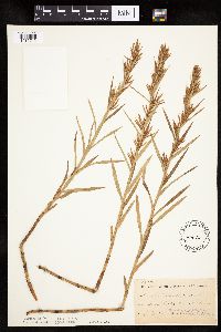 81478[1019712]Ballard, C. B7751891-07-00 United States, Minnesota, Carver, Swan Lake, Carver Co.;;116N;25W;9, 44.869838 -93.838803 |
MIN:Plants | 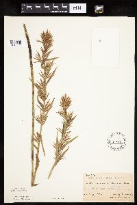 81479[1019653]MacMillan, C.; et al. MS161890-08-00 United States, Minnesota, Crow Wing, Brainerd.;;133N;28W;03, 46.368709 -94.200714 |
MIN:Plants | 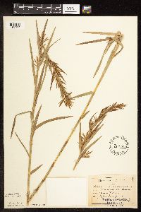 81480[1102479]Aiton, G. s.n.1889-07-00 United States, Minnesota, Hennepin, [no further data];;;;, 45 -93.47 |
MIN:Plants | 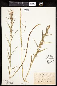 81481[1019655]Taylor, B. T14921892-07-00 United States, Minnesota, Chisago, Center City.;;034N;20W;, 45.42608 -92.83619 |
MIN:Plants |  81482[1019670]Sheldon, Edmund S30681892-07-00 United States, Minnesota, Mille Lacs, Milaca.;;037N;27W;, 45.692047 -93.698793 |
MIN:Plants |  81483[1019711]Ballard, C. B8331891-08-00 United States, Minnesota, Carver, Patterson Lake.;;116N;25W;, 44.8476 -93.827753 |
MIN:Plants |  81484[1019677]Anderson, A. An9021894-07-00 United States, Minnesota, Chisago, Center City.;;034N;20W;, 45.42608 -92.83619 |
MIN:Plants |  81485[1019671]Sheldon, Edmund s.n.1892-07-00 United States, Minnesota, Mille Lacs, Princeton.;;036N;26W;, 45.602777 -93.573848 |
MIN:Plants | 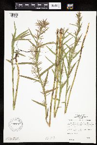 820331[1019726]Monson, Paul 45611964-08-19 United States, Minnesota, Becker, Becker Co. R36W, T142N, NE1/4 Sec. 10. Ca. 1/4 mi. S of Hwy. 113, 2.8 mi. W of the jct. with Hwy. 71.;;142N;36W;10, 47.130749 -95.222764 |
MIN:Plants | 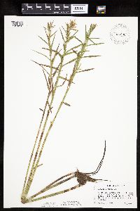 831036[1019626]Cholewa, A. 20871992-08-22 United States, Minnesota, Aitkin, Aitkin Co. Savanna State Forest, Camp Lakes, W (main) lake, ca. 2 mi N of hwy.6 on co.rd.75. T49N R23W Sec.13 NW1/4.;Savanna State Forest;049N;23W;13, 46.731105 -93.202145 |
MIN:Plants | 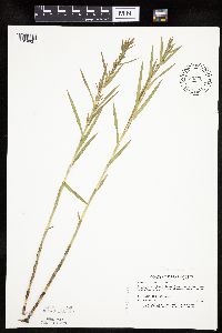 833104[1019631]Myhre, K. 28521992-07-27 United States, Minnesota, Cass, Cass Co. Located on the S shore of Mile Lake; T133N r29W SE1/4of SE1/4 of SEc.9;;133N;29W;9, 46.347481 -94.338084 |
MIN:Plants | 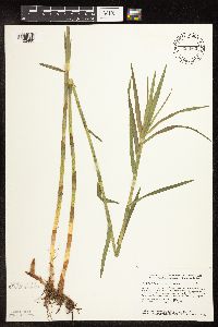 833660[1102480]Smith, Welby 142461988-06-17 United States, Minnesota, Washington, Washington Co. About 4.5 mi SE of Forest Lake (town); S side of Halfbreed Lake; SE1/4 SE1/4 sec.24, T32N R21W;;032N;21W;24, 45.2425003 -92.9005585 |
MIN:Plants |  834386[1019624]Smith, Welby 200901991-08-29 United States, Minnesota, Cook, Superior National Forest. Cook CO. About 5.5 mi N of Hovland, in the Superior National Forest; along the Swamp River; Cook CO. About 5.5 mi N of Hovland, in the Superior National Forest; along the Swamp River. T63N R4E NW1/4 of NE1/4 of Sec 21. 063N 04E 21, 47.9322205 -89.9433365 |
MIN:Plants |  836373[1019630]Smith, Welby 173601990-07-18 United States, Minnesota, Morrison, Camp Ripley Military Reservation. Camp Ripley Military Reservation Morrison Co. On the E side of Luzon Road. UTM: 389600E 5108500N T131N R30W NW1/4 of NW1 Camp Ripley Military Reservation Morrison Co. On the E side of Luzon Road. UTM: 389600E 5108500N T131N R30W NW1/4 of NW1/4 of Sec 35. 131N 30W 35, 46.114708 -94.42168 |
MIN:Plants |  839191[1102475]Boe, J. 930816011993-08-26 United States, Minnesota, Cass, Cass Co. Hole-in-the-bog Scientific and Natural Area; T144N R28W SE1/4 of NW1/4 of Sec 9.;Chippewa National Forest / Hole in Bog Scientific Natural Area / Leech Lake Indian Reservation;144N;28W;9, 47.303734 -94.231417 |
MIN:Plants |  839192[1019632]Mortensen, Steve; et al. 930826021993-08-26 United States, Minnesota, Cass, Cass County...Hole-in-the-bog Scientific and Natural Area; T144N R28W SE1/4 of NW1/4 of Sec 9.;Chippewa National Forest / Hole in Bog Scientific Natural Area / Leech Lake Indian Reservation;144N;28W;09, 47.303734 -94.231417 |
MIN:Plants |  839364[1019625]Cholewa, A. 23791995-07-28 United States, Minnesota, Aitkin, Savanna Portage State Park. Aitkin Co. Savanna Portage State Park, about 17 mi NE of McGregor, NW end of Wolf Lake near boat access, T50N R22W S6 NE Aitkin Co. Savanna Portage State Park, about 17 mi NE of McGregor, NW end of Wolf Lake near boat access, T50N R22W S6 NE1/4 of NW1/4. 050N 22W 6, 46.845996 -93.17745 |
MIN:Plants |  841151[1019639]Smith, Welby 134311987-07-08 United States, Minnesota, Washington, Washington Co. About 2 mi N of Scandia; NW1/4 NW1/4 sec.12, T32N R20W;;032N;20W;12, 45.2813873 -92.792778 |
MIN:Plants |  841302[1019650]Smith, Welby 144951988-07-05 United States, Minnesota, Washington, Warner Nature Center. Washington County...Lee and Rose Warner Nature Center, about 2.5 mi SW of Marine on St. Croix. Near the S end of Terrapin Lake. SW1/4 NE1/4 sec. 15, T31N R20W. 031N 20W 15, 45.1777778 -92.8241667 |
MIN:Plants |  841775[1019731]Smith, Welby 137241987-08-05 United States, Minnesota, Washington, Washington Co. About 5 mi W of Marine on St. Croix; NE1/4 NW1/4 sec.8, T31N R20W;;031N;20W;8, 45.188378 -92.865368 |
MIN:Plants | 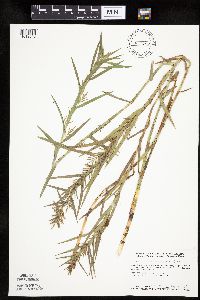 841782[1019640]Smith, Welby 137171987-08-04 United States, Minnesota, Washington, Washington Co. About 7 mi W of Marine on St. Croix; NW1/4 SE1/4 sec.11, T31N R21W;;031N;21W;11, 45.1877785 -92.9208298 |
MIN:Plants | 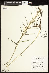 435657[1102483]Husveth, J. 95-1031995-08-07 United States, Minnesota, Wright, Wright Co, T120N R25W SE1/4 of the NW1/4 of S25;M Schmidt Crawford Woods Scientific Natural Area;120N;25W;25, 45.172755 -93.775987 |
MIN:Plants | 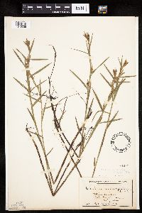 81459[1019739]Wheeler, William 7301900-08-00 United States, Michigan, Keweenaw, Tobin's Harbor, Isle Royale;Isle Royale National Park |
MIN:Plants | 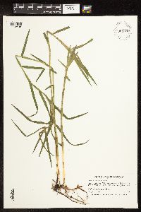 909773[1102498]Smith, Welby 246271994-07-11 United States, Minnesota, Koochiching, Koochiching County ... About three miles east of Northome ... Tuefer Lake ... T 151N R 28W SW1/4 of NE1/4 of Sec 27;;151N;28W;27, 47.8694444 -94.2183333 |
MIN:Plants | 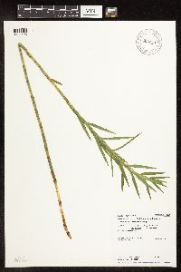 906255[1102495]Loso, Stephanie; et al. 10912007-07-12 United States, Minnesota, Cass, Cass County...Ada Lake...In the bay of Little Ada Lake. utm: N: 5187436 E: 398377. DNR Site# 699;;139N;29W;00, 46.848739 -94.343108 |
MIN:Plants | 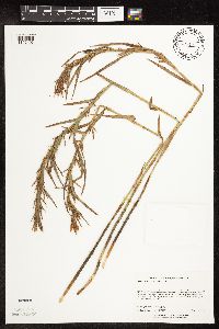 437900[1102496]Lee, Michael MDL31072001-08-22 United States, Minnesota, Lake, Lake County ... Along the shores of Egge Lake three miles north-northeast of Finland ...T57N R7W NW1/4 of NE1/4 Sec. 4;Finland State Forest;057N;07W;04, 47.450978 -91.224948 |
MIN:Plants | 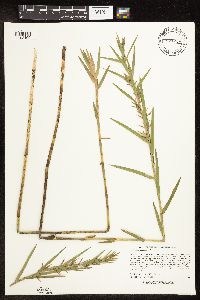 921234[1102499]Lee, Michael MDL35002003-07-25 United States, Minnesota, Todd, Todd County...south of Mound Lake, three miles east of Grey Eagle...lake at the base of the west side of 160-foot Eagle Mountain...T127N R32W SE1/4 of NE1/4 Sec. 10. 127N 32W 10, 45.824365 -94.695335 |
MIN:Plants | 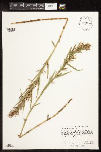 896947[1102497]Rowe, Erika ERR20060816022006-08-16 United States, Minnesota, Hubbard, Huntersville State Forest / Wildlife Management Area. Hubbard County...0.5 mile north of Cty Rd. 110; 4.9 miles NE of Huntersville...NE corner of Huntersville State Forest...where power line cuts through wetland...SWNW S36 T139N R33W. 139N 33W 36, 46.8061111 -94.8044444 |
MIN:Plants | 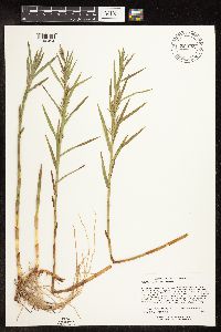 921662[1102494]Lee, Michael MDL35062003-07-28 United States, Minnesota, Todd, wetland complex...between Beck [=Breck?] and Buckhorn Lakes 4.5 miles southwest of Lincoln, nine miles northeast of Browerville...T131N R32W SW1/4ofSW1/4ofNW1/4 Sec. 15, NW1/4ofNW1/4ofSW1/4 Sec. 15. 131N 32W 15, 46.158138 -94.700035 |
MIN:Plants | 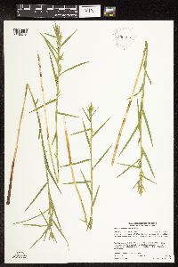 930685[1102472]Gerdes, Lynden B.; Smith, Welby R. 60342010-06-25 United States, Minnesota, Cook, Banadad Lake area. Unnamed bog lake approximately 0.08 miles north of the western end of Banadad Lake. NWSESWNE of section;Superior National Forest;064N;03W;10, 48.0402778 -90.6811111 |
MIN:Plants | 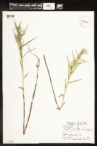 934144[1102473]Smith, Welby R. 335472011-08-29 United States, Minnesota, Dakota, About 7 miles N-NW of Northfield. NE of SE of section;Chub Lake Wildlife Area;113N;20W;33, 44.5510333 -93.22245 |
MIN:Plants | 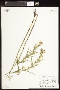 935370[1102474]Smith, Welby R; Gerdes, Lynden B 332972011-08-09 United States, Minnesota, Lake, At the west end of Lake Isabella where it joins the Isabella River. SE of NW of section;Boundary Waters Canoe Area Wilderness / Superior National Forest;062N;07W;31, 47.8108667 -91.2675167 |
MIN:Plants | 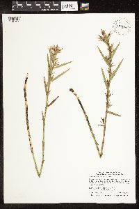 937108[1106797]Smith, Welby R. 322952010-09-05 United States, Minnesota, Lake, Along County Road 7 (Cramer Road) about 1.5 miles west of the Cook County Line. SW of SE of section [collector provided invalid longitude; estimated instead];Superior National Forest;061N;06W;02, 47.7919444 -91.0499972 |
MIN:Plants | 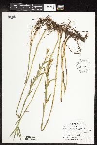 66435[1118911]Smith, Welby R.; Lee, Michael D. 320552010-08-09 United States, Minnesota, Cook, Along the north shore of Skinny Lake. SE of SW of section;Boundary Waters Canoe Area Wilderness / Superior National Forest;063N;02W;03, 47.9648208 -90.5702894 |
MIN:Plants | 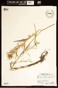 942045[1285215]Smith, Welby R. 319792010-07-29 United States, Minnesota, Koochiching, At the southwest end of Seretha Lake. SE of SE of section;;152N;27W;04, 48.0095725 -94.1064015 |
MIN:Plants | 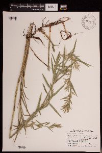 942994[1291118]Smith, Welby R. 347352013-08-01 United States, Minnesota, Crow Wing, At the west end of Duck Lake about 5.5 km (3.5 miles) E-NE of the town of Emily. NW of SE of section; T138N R25W sec19, 46.7504 -93.8898 |
MIN:Plants | 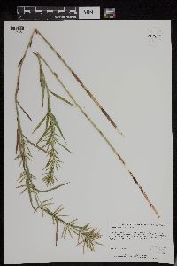 Dulichium arundinaceum var. arundinaceum (L.) Britton 952837[1295551]Kerns, Courtney CKK00722013-08-15 United States, Minnesota, Lake of the Woods, 48.62755 -94.43781, 335m |
MIN:Plants | 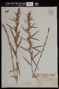 954121[1295737]Friesner, Ray C. 102191936-08-13 United States, Maine, Waldo |
MIN:Plants | 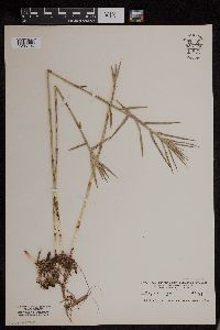 954122[1295736]Mowery, May s.n.1928-00-00 United States, Massachusetts, Barnstable |
MIN:Plants | 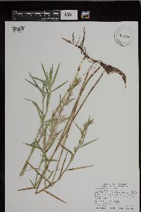 943488[1296956]Smith, Welby R. 340482012-07-23 United States, Minnesota, Pine |
MIN:Plants | 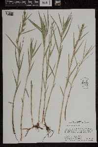 959175[1305383]Smith, Welby R. WRS353382015-06-28 United States, Minnesota, Hennepin, Crow-Hassan Regional Park, about 3 km (1.9 miles) southeast of St. Michael., 45.19035 -93.6417333 |
MIN:Plants | MPCA_Dummy26[]Michael Bourdaghs 2021-07-21 United States, Minnesota, Clearwater, White Earth Reservation, Collected as part of the US Environmental Protection Agency National Wetland Condition Assessment (EPA siteID NWC21-MN-10028) and MN Pollution Control Agency MN Wetland Condition Assessment (MPCA siteID 21CLEA028), 47.46582165 -95.49545378 |
MIN:Plants | 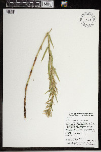 968210[1368828]Timothy J. S. Whitfeld 16402017-08-16 United States, Rhode Island, Washington, Frying Pan Pond, Wood River, 0.75 miles north-northwest of dam on Arcadia Road., 41.54914 -71.70397 |
MIN:Plants | 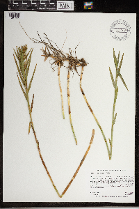 968445[1391038]Dahlberg, Nathan B. NBD2402020-08-11 United States, Minnesota, Todd, Grey Eagle WMA. 1 mile north of county 2; 4.5 miles west southwest of Grey Eagle., 45.82 -94.84 |
MIN:Plants | 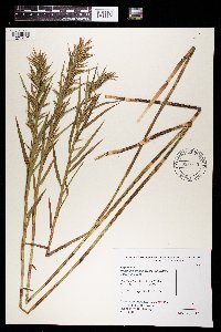 969829[1371417]B. Bartodziej 50-01 B2001-08-08 United States, Minnesota, Todd, Drainage Area: Grey Eagle WMA, 45.828473 -94.742735 |
MIN:Plants | 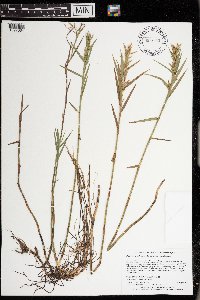 973530[1397084]Lee, Michael MDL57272011-08-30 United States, Minnesota, Lake, Boundary Waters Canoe Area Wilderness; Rugged bedrock terrain along the Canadian border, 34 miles east-northeast of Ely, on the ridge between the North and South Arms of Knife Lake., 48.10714168 -91.18441472, 436m |
MIN:Plants | 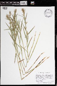 973271[1398824]Lee, Michael MDL59572012-07-02 United States, Minnesota, Lake, Boundary Waters Canoe Area Wilderness; Rolling bedrock terrain along the Four Mile Portage between Fall and Basswood Lakes, 10 miles northeast of Ely. Local on the southern shore of Muskeg Lake., 47.9839072305 -91.6812569421, 407m |
MIN:Plants | 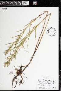 974440[1396804]Smith, Welby R WRS364092019-08-06 United States, Minnesota, Anoka, Carlos Avery State Wildlife Management Area, about 11.2 km (7 miles) southwest of the approximate center of Stacy at a heading of 225 degrees., 45.32775 -93.089 |
Google Map
Google Maps is a web mapping service provided by Google that features a map that users can pan (by dragging the mouse) and zoom (by using the mouse wheel). Collection points are displayed as colored markers that when clicked on, displays the full information for that collection. When multiple species are queried (separated by semi-colons), different colored markers denote each individual species.