University of Minnesota
http://www.umn.edu/
612-625-5000
http://www.umn.edu/
612-625-5000
Minnesota Biodiversity Atlas
Bell Museum
Dataset: MIN-Plants
Taxa: Elaeagnaceae
Search Criteria: excluding cultivated/captive occurrences
Bell Museum plants | |
 MIN:Plants | Shepherdia argentea (Pursh) Nuttall 288345[]Moore, John; Huff, N. 185011946-06-06 United States, Minnesota, Brown, Flandrau State Park;Flandrau State Park;N;;, 44.288296 -94.473584 |
MIN:Plants | Shepherdia argentea (Pursh) Nuttall 349092[]Rosendahl, C.; et al. 30461935-05-19 United States, Minnesota, Pipestone, Pipestone;;106N;46W;, 44.00056 -96.31722 |
MIN:Plants | Shepherdia argentea (Pursh) Nuttall 363209[]Beach, W. 171913-04-21 United States, Minnesota, Ramsey, Nursery, University [of Minn.] Farm, St. Paul;;029N;23W;, 44.992077 -93.166387 |
MIN:Plants | Shepherdia argentea (Pursh) Nuttall 370190[]Moore, John; et al. 142341941-06-13 United States, Minnesota, Norman, Beside Hwy. 75, 5 1/2 mi. NE of Hendrum. Norman Co.;;;;, 47.320683 -96.72851 |
MIN:Plants | Shepherdia argentea (Pursh) Nuttall 551621[]Cotter Tucker, Shirley 41631957-06-27 United States, Minnesota, Polk, Along the Great Northern R.R, E of Northwest School, Crookston;;N;;, 47.774138 -96.608121 |
MIN:Plants | Shepherdia argentea (Pursh) Nuttall 554084[]Moore, John; et al. 223991954-09-23 United States, Minnesota, Pipestone, Pipestone County...Pipestone Quarry, Pipestone National Monument, Pipestone;Pipestone National Monument;106N;46W;01, 44.015848 -96.317669 |
MIN:Plants | Shepherdia argentea (Pursh) Nuttall 554346[]Moore, John 229951956-09-12 United States, Minnesota, Clay, Along the Red River, 4 mi. N of Moorhead;;N;;, 46.933022 -96.768177 |
MIN:Plants | Shepherdia argentea (Pursh) Nuttall 683067[]Morley, T. 13491977-07-25 United States, Minnesota, Lyon, Along bank of Coon Creek. NW-facing bank above the creek flowing SW at this point, ca. 1/2 mi. W of Russell. T110N, R4 Along bank of Coon Creek. NW-facing bank above the creek flowing SW at this point, ca. 1/2 mi. W of Russell. T110N, R43W, Sec. 24, slightly W and N of center of the N1/2 of the SE1/4. 110N 43W 24, 44.319641 -95.968039 |
MIN:Plants | Shepherdia argentea (Pursh) Nuttall 743889[]Ownbey, Gerald 66851981-05-18 United States, Minnesota, Lyon, Russell. On proposed Nature Conservancy tract just N of the village.;;N;;, 44.35921 -95.92627 |
MIN:Plants | Shepherdia argentea (Pursh) Nuttall 795851[]Cotter, Shirley 5721948-08-07 United States, Minnesota, Clearwater, Nursery on grounds of Univ. of Minn. Biol. Sta, Itasca Park;Itasca State Park;143N;36W;, 47.19557 -95.233216 |
MIN:Plants | Shepherdia argentea (Pursh) Nuttall 816023[]Wheeler, Gerald 111441988-07-16 United States, Minnesota, Traverse, Browns Valley (NE side); W of Rte. 2. NW1/4 NE1/4 Sec. 34, T125N, R49W (Folsom Twp.);;125N;49W;34, 45.593308 -96.813211 |
MIN:Plants | Shepherdia argentea (Pursh) Nuttall 833831[]Smith, Welby 141841988-06-02 United States, Minnesota, Big Stone, Big Stone Co. About 4 mi SE of Browns Valley. SW1/4 SW1/4 sec 14, T124N R49W;;124N;49W;14, 45.552905 -96.771812 |
MIN:Plants | Shepherdia argentea (Pursh) Nuttall 905703[]Smith, Welby 294202003-07-22 United States, Minnesota, Douglas, SE1/4 of SW1/4 of section;Red Rock Wildlife Management Area;128N;40W;20, 45.8772222 -95.7308333 |
MIN:Plants | Shepherdia argentea (Pursh) Nuttall 905280[]Smith, Welby 294202003-07-22 United States, Minnesota, Douglas, Douglas County...Red Rock State Wildlife Management Area...T 128N R 40W SE1/4 of SW1/4 of Sec 20;Red Rock Wildlife Management Area;128N;40W;20, 45.8772222 -95.7308333 |
MIN:Plants | Shepherdia argentea (Pursh) Nuttall 499752[]Whitfeld, T.J.S. 4402003-06-27 United States, Minnesota, Douglas, Douglas County ...3 miles northeast of Melby; 1/4 mile east of Lake Christina; on south side of County Hwy. 52 ... T130N R40W NWNE 11. 130N 40W 11, 46.085674 -95.67614 |
MIN:Plants | Shepherdia argentea (Pursh) Nuttall 794831[]Schaaf, J. 1301982-08-17 United States, Nevada, Humboldt, Humboldt Co. ... Pine Canyon, Santa Rosa Mts., 1646m |
MIN:Plants | Shepherdia argentea (Pursh) Nuttall 482396[]Anderson, Craig 12992001-07-11 United States, Minnesota, Pope, Pope Co.; T123N R39W: 1/4 of NE1/4 of NE1/4 of Sect. 35;;123N;39W;35, 45.419335 -95.531055 |
MIN:Plants | Shepherdia argentea (Pursh) Nuttall 456745[]Nash, A. 32881966-07-22 United States, Wyoming, Park, Clematis Gulch;Yellowstone National Park |
MIN:Plants | Shepherdia argentea (Pursh) Nuttall 520496[]Nash, A. 32871966-07-22 United States, Wyoming, Park, Clematis Gulch;Yellowstone National Park |
MIN:Plants | Shepherdia argentea (Pursh) Nuttall 215884[]Nash, A.; Nash, V. 32891966-07-22 United States, Wyoming, Park, Clematis Gulch;Yellowstone National Park |
MIN:Plants | Elaeagnus commutata Bernhardi ex Rudberg 539869[]Tester, John s.n.1957-07-04 United States, Minnesota, Mahnomen, Mahnomen County...Waubun Prairie. 3-4 miles W. and 1 mile S. of Waubun. Sec. 33, T. 143N, R. 42W.;Waubun Prairie Wildlife Management Area / White Earth Indian Reservation;143N;42W;33, 47.158904 -96.00743 |
MIN:Plants | Elaeagnus commutata Bernhardi ex Rudberg 157976[]Sheldon, Edmund S70921893-09-00 United States, Minnesota, Traverse, Brown's Valley;;N;;, 45.595239 -96.833407 |
MIN:Plants | Elaeagnus commutata Bernhardi ex Rudberg 158299[]MacMillan, C.; et al. 53Sk1900-08-00 United States, Minnesota, Polk, Crookston;;150N;46W;30, 47.782 -96.60007 |
MIN:Plants | Elaeagnus commutata Bernhardi ex Rudberg 158300[]Ballard, C. 28011900-08-00 United States, Minnesota, Marshall, Warren;;N;;, 48.196642 -96.77284 |
MIN:Plants | Elaeagnus commutata Bernhardi ex Rudberg 158301[]Ballard, C. 25781900-08-00 United States, Minnesota, Kittson, St. Vincent;;163N;51W;, 48.945898 -97.210703 |
MIN:Plants | Elaeagnus commutata Bernhardi ex Rudberg 291933[]Hotchkiss, N.; et al. 40511930-08-20 United States, Minnesota, Marshall, Near Viking. Marshall Co.;;;;, 48.218584 -96.40588 |
MIN:Plants | Elaeagnus commutata Bernhardi ex Rudberg 307038[]Rosendahl, C.; Moyle, J. 20171935-06-21 United States, Minnesota, Mahnomen, 4 mi. E of Beaulieu;White Earth Indian Reservation;145N;40W;, 47.367744 -95.741574 |
MIN:Plants | Elaeagnus commutata Bernhardi ex Rudberg 356145[]Stevens, O. s.n.1937-07-13 United States, Minnesota, Polk, Melvin, Polk Co.;;148N;45W;22, 47.622952 -96.377032 |
MIN:Plants | Elaeagnus commutata Bernhardi ex Rudberg 359899[]Rosendahl, C.; et al. 70631938-09-04 United States, Minnesota, Marshall, Near r.r. tracks; 2 mi. S of Holt;;;;, 48.26297 -96.192531 |
MIN:Plants | Elaeagnus commutata Bernhardi ex Rudberg 360730[]Rosendahl, C.; et al. 70291938-09-04 United States, Minnesota, Roseau, Campbell Beach, 5 mi. W of Greenbush;;;;, 48.70048 -96.291318 |
MIN:Plants | Elaeagnus commutata Bernhardi ex Rudberg 364986[]Swanson, Gustav s.n.1940-06-11 United States, Minnesota, Polk, N of Erskine;;N;;, 47.685493 -96.00729 |
MIN:Plants | Elaeagnus commutata Bernhardi ex Rudberg 370318[]Moore, John; et al. 144811941-06-15 United States, Minnesota, Marshall, SE1/4 Sec. 36, Excel Twp.;;;;, 48.218056 -96.183333 |
MIN:Plants | Elaeagnus commutata Bernhardi ex Rudberg 372448[]Moore, John; et al. 145801941-06-15 United States, Minnesota, Mahnomen, Beside Hwy. 59, 3 1/2 mi. S of Winger;White Earth Indian Reservation;146N;42W;, 47.455753 -96.000327 |
MIN:Plants | Elaeagnus commutata Bernhardi ex Rudberg 372462[]Moore, John; et al. 145661941-06-15 United States, Minnesota, Polk, Beside Hwy. 59, 1 1/2 mi. N of Winger;;;;, 47.55765 -95.98223 |
MIN:Plants | Elaeagnus commutata Bernhardi ex Rudberg 372474[]Moore, John; et al. 145541941-06-15 United States, Minnesota, Red Lake, Beside Hwy. 59; Brooks;;150N;42W;, 47.803911 -96.030958 |
MIN:Plants | Elaeagnus commutata Bernhardi ex Rudberg 381649[]Moore, John 156041942-06-28 United States, Minnesota, Mahnomen, Mahnomen Co. 1 mi N of Bejou;White Earth Indian Reservation;146N;42W;, 47.455753 -96.000327 |
MIN:Plants | Elaeagnus commutata Bernhardi ex Rudberg 381673[]Moore, John 155571942-06-28 United States, Minnesota, Polk, 5 mi. W of Fertile on the Beltrami Road;;N;;, 47.536027 -96.387534 |
MIN:Plants | Elaeagnus commutata Bernhardi ex Rudberg 412848[]Moore, John; Moore, Marjorie 115831939-08-09 United States, Minnesota, Kittson, 1.8 mi. N of Orleans;;N;;, 48.952143 -96.936719 |
MIN:Plants | Elaeagnus commutata Bernhardi ex Rudberg 445967[]Moore, John; et al. 173191945-06-20 United States, Minnesota, Red Lake, Red Lake County...5 mi N of Red Lake Falls;;152N;44W;, 47.954768 -96.279707 |
MIN:Plants | Elaeagnus commutata Bernhardi ex Rudberg 446023[]Moore, John 172221945-06-17 United States, Minnesota, Pennington, 9 mi. W of Thief River Falls;;N;;, 48.121767 -96.343684 |
MIN:Plants | Elaeagnus commutata Bernhardi ex Rudberg 446185[]Moore, John 172011945-06-16 United States, Minnesota, Marshall, 5 mi. E of Warren;;N;;, 48.196591 -96.664277 |
MIN:Plants | Elaeagnus commutata Bernhardi ex Rudberg 488500[]Moore, John 199041949-05-10 United States, Minnesota, Red Lake, Red Lake Co. Dorothy;;151N;45W;, 47.891016 -96.417549 |
MIN:Plants | Elaeagnus commutata Bernhardi ex Rudberg 501090[]Moore, John 203441949-06-28 United States, Minnesota, Kittson, 1/2 mi. W of Karlstad;;N;;, 48.577476 -96.531534 |
MIN:Plants | Elaeagnus commutata Bernhardi ex Rudberg 542576[]Moore, John 218531954-07-20 United States, Minnesota, Wilkin, 3 1/2 mi. SW of Campbell;;N;;, 46.061893 -96.456463 |
MIN:Plants | Elaeagnus commutata Bernhardi ex Rudberg 554257[]Moore, John 228941956-06-12 United States, Minnesota, Norman, 8 1/2 mi. E of Ada;;N;;, 47.299546 -96.333914 |
MIN:Plants | Elaeagnus commutata Bernhardi ex Rudberg 554391[]Moore, John 231221957-05-29 United States, Minnesota, Clay, Clay County...Along the r.r, 1 mi. S of Glyndon;;139N;47W;11, 46.869895 -96.578669 |
MIN:Plants | Elaeagnus commutata Bernhardi ex Rudberg 554532[]Moore, John 229321956-06-14 United States, Minnesota, Norman, 7 mi. E of Lockhart;;N;;, 47.43987 -96.40137 |
MIN:Plants | Elaeagnus commutata Bernhardi ex Rudberg 554678[]Moore, John 230441956-09-15 United States, Minnesota, Clay, 6 1/2 mi. NE of Felton;;N;;, 47.145067 -96.408758 |
MIN:Plants | Elaeagnus commutata Bernhardi ex Rudberg 573814[]Stevens, O.; et al. 24571961-07-02 United States, Minnesota, Polk, Ridge of Herman Beach, Melvin, Polk Co.;;148N;45W;00, 47.62967 -96.38702 |
MIN:Plants | Elaeagnus commutata Bernhardi ex Rudberg 574467[]Moore, John; et al. 248601959-09-19 United States, Minnesota, Kittson, Kittson County...1 mi. SW of Caribou;;;;, 48.981458 -96.451028 |
MIN:Plants | Elaeagnus commutata Bernhardi ex Rudberg 585725[]Moore, John 261191962-06-29 United States, Minnesota, Kittson, Along the r.r, 2 mi. SE of Orleans;;N;;, 48.905625 -96.905571 |
MIN:Plants | Elaeagnus commutata Bernhardi ex Rudberg 594187[]Thorne, Robert 307251962-06-28 United States, Minnesota, Mahnomen, Mahnomen Co.; between r.r. and hwy, just S of Bejou; NE1/4 Sec. 27, T146N, R42W, Bejou Twp.;White Earth Indian Reservation;146N;42W;27, 47.434019 -95.986792 |
MIN:Plants | Elaeagnus commutata Bernhardi ex Rudberg 628117[]Ownbey, Gerald 46841972-08-18 United States, Minnesota, Mahnomen, Mahnomen Co. Rt. 200, 9.0 mi E of its jct. with Rt. 59, Mahnomen. Near Perch Lake.;White Earth Indian Reservation;145N;40W;, 47.367744 -95.741574 |
MIN:Plants | Elaeagnus commutata Bernhardi ex Rudberg 707915[]Smith, Welby 12341979-08-03 United States, Minnesota, Lac Qui Parle, T118N, R46W, NW1/4 Sec. 4. 0.5 mi. E of Nassau. Between Peg Lake and Co. Hwy. 24.;;118N;46W;4, 45.059123 -96.424984 |
MIN:Plants | Elaeagnus commutata Bernhardi ex Rudberg 711601[]Smith, Welby 15161979-08-21 United States, Minnesota, Wilkin, T133N, R45W, NE1/4 Sec. 24. "Fox Home Prairie". 9 mi. due S of Rothsay.;Foxhome Prairie, The Nature Conservancy;133N;45W;24, 46.318653 -96.290714 |
MIN:Plants | Elaeagnus commutata Bernhardi ex Rudberg 715245[]Severson, M. 1511979-09-01 United States, Minnesota, Polk, (TNC) 4.5 mi. S of Fischer, W1/2 of NW1/4 of Sec. 16;Malmberg Prairie Scientific Natural Area;149N;48W;16, 47.72417 -96.813965 |
MIN:Plants | Elaeagnus commutata Bernhardi ex Rudberg 721465[]Farrell, P. 2371979-08-29 United States, Minnesota, Polk, 7 mi. SE of Crookston. S1/2 of section;Pankratz Memorial Prairie, The Nature Conservancy;149N;45W;08, 47.73852 -96.44879 |
MIN:Plants | Elaeagnus commutata Bernhardi ex Rudberg 721568[]Keller, C.; et al. 201979-06-11 United States, Minnesota, Polk, Pankratz Prairie North: (TNC) 7 mi. SE of Crookston, S1/2 Sec. 8, T149N, R45W.;Pankratz Memorial Prairie, The Nature Conservancy;149N;45W;08, 47.738517 -96.448789 |
MIN:Plants | Elaeagnus commutata Bernhardi ex Rudberg 728053[]Severson, M. 361979-06-22 United States, Minnesota, Polk, Pankratz Prairie South: (TNC) 7 mi. SE of Crookston, SE1/4 of Sec. 17, NE1/4 of Sec. 20, T149N, R45W.;Pankratz Memorial Prairie, The Nature Conservancy;149N;45W;, 47.716767 -96.416687 |
MIN:Plants | Elaeagnus commutata Bernhardi ex Rudberg 728771[]Herman, J. 841979-07-11 United States, Minnesota, Mahnomen, Mahnomen Co. Santee Prairie: 3 mi SE of Bejou, Sec. 6, 7, T145N, R41W.;Santee Prairie Scientific Natural Area / White Earth Indian Reservation;145N;41W;, 47.368425 -95.869122 |
MIN:Plants | Elaeagnus commutata Bernhardi ex Rudberg 758419[]Smith, Welby 68481982-07-22 United States, Minnesota, Polk, Polk County...On the N side of Hwy. 45, about 12 mi. ESE of Crookston...NW1/4 NW1/4 Sec. 19, T149N, R44W.;Pembina Trail Preserve Scientific Natural Area;149N;44W;19, 47.709227 -96.341088 |
MIN:Plants | Elaeagnus commutata Bernhardi ex Rudberg 782122[]Dana, R. 850931985-08-02 United States, Minnesota, Norman, W end of S1/2 Sec. 10, T143N, R45W.;;143N;45W;10, 47.216475 -96.374924 |
MIN:Plants | Elaeagnus commutata Bernhardi ex Rudberg 479688[]Schimpf, D. DJS2812000-06-10 United States, Minnesota, Saint Louis, St. Louis Co, Mountain Iron. T58N R18W SW1/4 of NE1/4 Sec 9; Mott Mine dump, S of Mountain Iron.;;058N;18W;9, 46.7083321 -92.2833328 |
MIN:Plants | Elaeagnus commutata Bernhardi ex Rudberg 905794[]Smith, Welby 294242003-08-01 United States, Minnesota, Polk, Polk County...Along Hwy 102, about 9 mi NW of its junction with Hwy 32 in Fertile...T148N R45W NW1/4 of SE1/4 of Sec 8;;148N;45W;08, 47.6516667 -96.4155556 |
MIN:Plants | Elaeagnus commutata Bernhardi ex Rudberg 158291[]Burglehaus, F. s.n.1893-08-00 United States, Wyoming, Park, Yellowstone National Park...near Mammoth Hot Springs;Yellowstone National Park, 1524m |
MIN:Plants | Elaeagnus commutata Bernhardi ex Rudberg 493459[]Smith, Welby 279081999-06-15 United States, Minnesota, Kittson, Pelan Wildlife Management Area. Kittson County ... Pelan State Wildlife Management Area, about 7 miles E-NE of Halma ... T 160N R 45W SE1/4 of SE1/4 of Sec 15. 160N 45W 15, 48.6758347 -96.434166 |
MIN:Plants | Elaeagnus commutata Bernhardi ex Rudberg 489452[]Smith, Welby 278071999-05-28 United States, Minnesota, Marshall, Marshall County ... Old Mill State Park, about 11 miles west of Newfolden ... T156N R46W NW1/4 of SW1/4 of Sec 4;Old Mill State Park;156N;46W;04, 48.3611107 -96.5730591 |
MIN:Plants | Elaeagnus commutata Bernhardi ex Rudberg 158298[]Burglehaus, F. s.n.1893-08-00 United States, Wyoming, Park, Yellowstone National Park...near Mammoth Hot Springs;Yellowstone National Park, 1524m |
MIN:Plants | Elaeagnus commutata Bernhardi ex Rudberg 905465[]Smith, Welby 294242003-08-01 United States, Minnesota, Polk, Polk County...Along Hwy 102, about 9 miles northwest of its junction with Hwy 32 in Fertile...T148N R45W NW1/4 of SE1/4 of Sec 8. 148N 45W 8, 47.6516667 -96.4155556 |
MIN:Plants | 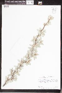 Elaeagnus commutata Bernhardi ex Rudberg 960919[1334001]Anderson, Derek S. 25812016-06-02 United States, Minnesota, Polk, Thorson Prairie WMA, About 17 km northwest of Fertile on State Highway 102., 47.66 -96.41 |
MIN:Plants | 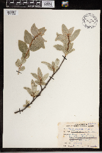 Elaeagnus commutata Bernhardi ex Rudberg 967798[1368400]Drew, L.A. s.n.1969-07-02 United States, Minnesota, Mahnomen, 8 miles E Mahnomen; T144N R40W sec. 5 NW NW 1/4, 47.322621 -95.781917 |
MIN:Plants | Elaeagnus umbellata Thunb. 931827[]Schimpf, D. DJS6652012-04-28 United States, Minnesota, Houston, Crooked Creek Township. SE1/4 of section;Dorer Memorial Hardwood State Forest;102N;04W;23, 43.6163889 -91.2731944 |
MIN:Plants | Elaeagnus umbellata Thunb. 943982[]Isackson, Angela s.n.2015-09-30 United States, Minnesota, Hennepin, Found in woodlot west of entrance road to Nursery;Crow Hassan Park Reserve;;;, 45.18809 -93.63647 |
MIN:Plants | Elaeagnus umbellata Thunb. 944769[]Dziuk, Peter M. PMD15-0222015-05-18 United States, Minnesota, Le Sueur, Co. Rd. 12 ~3 miles NNE of Waterville, both sides of road. T109N, R23W, Sec. 16., 44.253056 -93.58583 |
MIN:Plants | Elaeagnus umbellata Thunb. 947438[]Dziuk, Peter M. PMD15-0262015-05-19 United States, Minnesota, Anoka, Just north of Co Rd J at intersection with Otter Lake Rd. on both east and west sides of Otter Lake Road. T31N R22W Sec. 35, 45.124269 -93.048036 |
MIN:Plants | Elaeagnus umbellata Thunb. 947435[]Dziuk, Peter M. PMD15-0252015-06-03 United States, Minnesota, Houston, Base of bluff just weest of downtown Reno. T102N R4W Sec. 23, 43.602161 -91.279025 |
MIN:Plants | 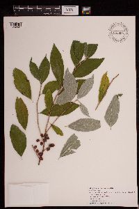 Elaeagnus umbellata Thunb. 953596[1292841]Becker, Benjamin s.n. United States, Minnesota, Pine, 46.107231 -92.508777 |
MIN:Plants | 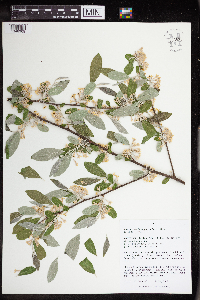 Elaeagnus umbellata Thunb. 963525[1348909]Nee, M. H. 642012018-05-24 United States, Wisconsin, Richland, 4.5km (by air) NW of Muscada; Frank's hill, 43.307083 -90.333056, 227m |
MIN:Plants |  Elaeagnus umbellata Thunb. 968094[1368659]Timothy J. S. Whitfeld 12342016-05-16 United States, Rhode Island, Providence, Lime Rock Preserve, east parcel off Sherman Avenue, 1/4 mile east of Route 146., 41.91715 -71.45248 |
MIN:Plants |  Elaeagnus umbellata Thunb. 968091[1368662]Timothy J. S. Whitfeld 13822016-08-11 United States, Rhode Island, Providence, Scott Brook Preserve, off Scott Road, 0.8 miles north of Interstate 295., 41.96077 -71.43077 |
MIN:Plants |  Elaeagnus umbellata Thunb. 968158[1368751]Hayley Uno 522017-10-13 United States, Rhode Island, Providence, East Bay Bike Path near Watchemoket Cove, off Veterans Memorial Parkway., 41.8026027778 -71.382875, 5m |
MIN:Plants |  Elaeagnus umbellata Thunb. 971303[1394780]M. H. Nee 660442020-07-15 United States, Wisconsin, Crawford, 5.5km NNE of center of Boscobel, along Georgetown Road. T8N R3W NE 1/4 SW 1/4 sect 11, 43.184444 -90.699444, 310m |
MIN:Plants | 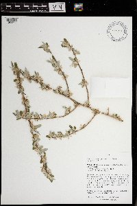 Elaeagnus umbellata Thunb. 971296[1394773]M. H. Nee 655852020-05-26 United States, Wisconsin, Iowa, Governor Dodge State Park, along Mill Creek Trail. T 6 N; R 3 E; SE¼NE¼ sect. 11, 43.015278 -90.095556, 315m |
MIN:Plants | 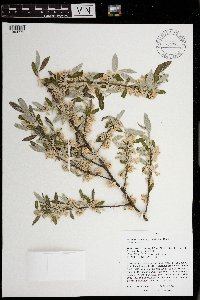 Elaeagnus umbellata Thunb. 971295[1394772]M. H. Nee 656082020-05-26 United States, Wisconsin, Iowa, 7.5km N of center of Dodgeville, Governor Dodge State Park. T 6 N; R 3 E; NE¼NW¼ sect. 3., 43.031111 -90.125556, 380m |
MIN:Plants | 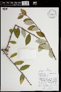 Elaeagnus umbellata Thunb. 971294[1394771]M. H. Nee 662302020-08-16 United States, Wisconsin, Richland, 1.5km WSW of Port Andrew, along Wisconsin River. T8N R2W; NE 1/4 NE 1/4 sect. 3, 43.201667 -90.590278, 208m |
MIN:Plants | 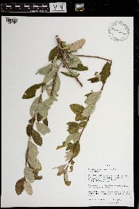 Elaeagnus umbellata Thunb. 971280[1394757]M. H. Nee 661982020-08-11 United States, Wisconsin, Grant, 5.5 km ESE of Lancaster, N side of Lincoln Road, Eldred Prairie. T 4 N; R 2 W; SW¼NW¼ sect. 8., 42.836667 -90.641389, 290m |
Google Map
Google Maps is a web mapping service provided by Google that features a map that users can pan (by dragging the mouse) and zoom (by using the mouse wheel). Collection points are displayed as colored markers that when clicked on, displays the full information for that collection. When multiple species are queried (separated by semi-colons), different colored markers denote each individual species.