University of Minnesota
http://www.umn.edu/
612-625-5000
http://www.umn.edu/
612-625-5000
Minnesota Biodiversity Atlas
Bell Museum
Dataset: MIN-Plants
Taxa: Ericaceae
Search Criteria: excluding cultivated/captive occurrences
Bell Museum plants | |
 MIN:Plants | Pyrola asarifolia Michaux 525649[]Lakela, Olga 187011955-06-05 United States, Minnesota, Saint Louis, Hwy. 53, N of Ash Lake;Kabetogama State Forest;N;;, 48.232756 -92.926298 |
MIN:Plants | Pyrola asarifolia Michaux 525736[]Lakela, Olga 187751955-07-09 United States, Minnesota, Saint Louis, Bank of the White Face River S of Meadowlands;;N;;, 47.063845 -92.715979 |
MIN:Plants | Pyrola asarifolia Michaux 525872[]Lakela, Olga 186391955-06-04 United States, Minnesota, Saint Louis, N of Ash Lake, Hwy. 53;Kabetogama State Forest;N;;, 48.226124 -92.921491 |
MIN:Plants | Pyrola asarifolia Michaux 527499[]Carter, J.; et al. 191981-06-22 United States, Minnesota, Saint Louis, County: St. Louis; in Bass Lake. Elev. 1445 ft. R-12W T-63N Sec.9;;063N;12W;09, 47.9551324 -91.8746597 |
MIN:Plants | Pyrola asarifolia Michaux 532287[]Lakela, Olga 200381956-06-25 United States, Minnesota, Saint Louis, Border of Hwy. 74, W of Gheen;;063N;20W;00, 47.967752 -92.919076 |
MIN:Plants | Pyrola asarifolia Michaux 532289[]Lakela, Olga 205501956-07-25 United States, Minnesota, Saint Louis, White Cedar Forest, Hwy. 53, S of Ash River Jct.;Kabetogama State Forest;N;;, 48.218584 -92.915512 |
MIN:Plants | Pyrola asarifolia Michaux 532290[]Lakela, Olga; Elwell, M. 205821956-08-26 United States, Minnesota, Saint Louis, Hwy. 53, S of Ash River Jct.;Kabetogama State Forest;N;;, 48.374927 -92.979458 |
MIN:Plants | Pyrola asarifolia Michaux 532643[]Lakela, Olga 204621956-07-14 United States, Minnesota, Lake, E of Four-Mile portge to Basswood Lake;Boundary Waters Canoe Area Wilderness / Superior National Forest;N;;, 47.999308 -91.666903 |
MIN:Plants | Pyrola asarifolia Michaux 532922[]Lakela, Olga 198361956-06-16 United States, Minnesota, Saint Louis, On a point facing the narrows of Seven Beaver Lake;Superior National Forest;N;;, 47.499159 -91.811429 |
MIN:Plants | Pyrola asarifolia Michaux 532963[]Lakela, Olga 201871956-07-01 United States, Minnesota, Saint Louis, S bank of Little Fork River, Hwy. 5 near the bridge;;N;;, 47.8167 -92.45 |
MIN:Plants | Pyrola asarifolia Michaux 542716[]Moore, John 216151952-05-23 United States, Minnesota, Beltrami, along the banks of the Mississippi River 11 mi SE of Bemidji;;N;;, 47.45058 -94.720182 |
MIN:Plants | Pyrola asarifolia Michaux 543557[]Lakela, Olga 221741957-08-20 United States, Minnesota, Lake, Endless Waters Trail, Kawishiwi River Range;Boundary Waters Canoe Area Wilderness / Superior National Forest;N;;, 47.816363 -91.720989 |
MIN:Plants | Pyrola asarifolia Michaux 551248[]Cotter, Shirley 2050c1951-07-15 United States, Minnesota, Crow Wing, Pelican Lake, N of Brainerd;;N;;, 46.572297 -94.177481 |
MIN:Plants | Pyrola asarifolia Michaux 560839[]Ownbey, Gerald; Anderson, Henry 27721959-07-01 United States, Minnesota, Clearwater, NE1/4 S1, T147N, R38W, W shore of Lone Lake, ca 4 straight-line mi NNW of Bagley;;147N;38W;1, 47.5798825 -95.4365844 |
MIN:Plants | Pyrola asarifolia Michaux 560852[]Ownbey, Gerald 22141955-06-24 United States, Minnesota, Clearwater, Iron Springs Bog, just N of Itasca State Park near Hwy. 2;Itasca State Park;143N;36W;, 47.254464 -95.243163 |
MIN:Plants | Pyrola asarifolia Michaux 572890[]Moore, John 255691961-07-06 United States, Minnesota, Isanti, Along the S shore of Ice Lake, Cedar Creek Natural History Area.;Cedar Creek National History Area;034N;23W;, 45.421038 -93.207399 |
MIN:Plants | Pyrola asarifolia Michaux 574638[]Moore, John; et al. 248281959-09-18 United States, Minnesota, Kittson, Kittson County...9 mi. E of Hallock;;;;, 48.776179 -96.756069 |
MIN:Plants | Pyrola asarifolia Michaux 582447[]Isaak, Daniel s.n.1958-00-00 United States, Minnesota, Clearwater, Itasca State Park, across hwy from the biological station;Itasca State Park;143N;36W;, 47.247949 -95.169091 |
MIN:Plants | Pyrola asarifolia Michaux 583315[]Kellner, H. 4441956-07-20 United States, Minnesota, Cook, Cook County...by shore of small lake below Mt. Josephine;Grand Portage Indian Reservation / North Shore;063N;06E;03, 47.985633 -89.662689 |
MIN:Plants | Pyrola asarifolia Michaux 588017[]Marion, J. s.n.1982-00-00 United States, Minnesota, Cook, Cook Co, North Shore of Lake Superior, ca. 200 ft. from lakeshore;North Shore;;;, 47.46396 -91.02551 |
MIN:Plants | Pyrola asarifolia Michaux 590147[]Meierotto, R. s.n.1963-07-26 United States, Minnesota, Clearwater, S12, T143N, R36W;;143N;36W;12, 47.2177418 -95.1801688 |
MIN:Plants | Pyrola asarifolia Michaux 594262[]Thorne, Robert 304791962-06-18 United States, Minnesota, Clearwater, near entrance to tourist campground, Itasca State Park;Itasca State Park;143N;36W;, 47.187659 -95.222563 |
MIN:Plants | Pyrola asarifolia Michaux 600707[]Baker, Gary 27301966-06-16 United States, Minnesota, Saint Louis, Along the French River, S of Old North Shore Road.;;N;;, 46.901863 -91.900347 |
MIN:Plants | Pyrola asarifolia Michaux 600709[]Baker, Gary 27271966-06-16 United States, Minnesota, Saint Louis, Duluth. North Shore Drive across the road from Loneyville Motel, 2 mi. E of the Lester River. Ca. 50 ft. from Lake Sup Duluth. North Shore Drive across the road from Loneyville Motel, 2 mi. E of the Lester River. Ca. 50 ft. from Lake Superior.. N , 46.856556 -91.977773 |
MIN:Plants | Pyrola asarifolia Michaux 602851[]Ownbey, Gerald 41041967-06-29 United States, Minnesota, Polk, 2.0 mi. W of Fertile.;;N;;, 47.536069 -96.323213 |
MIN:Plants | Pyrola asarifolia Michaux 607697[]Westkaemper, Remberta s.n.1968-06-00 United States, Minnesota, Stearns, Stearns Co. Collegeville;;125N;30W;, 45.594409 -94.363053 |
MIN:Plants | Pyrola asarifolia Michaux 616450[]Moore, John; Moore, Marjorie 1921969-06-18 United States, Minnesota, Crow Wing, Crow Wing Natural History Area, SE of old barn, SW1/4 SW1/4 S6, Garrison Twp;Crow Wing Natural Area;044N;28W;6, 46.3230967 -93.9262873 |
MIN:Plants | Pyrola asarifolia Michaux 616650[]Moore, John; Moore, Marjorie 2541969-07-02 United States, Minnesota, Crow Wing, SE of old barn, SW1/4 SW1/4 Sec. 6, Garrison Twp.;Crow Wing Natural Area;044N;28W;6, 46.3230967 -93.9262873 |
MIN:Plants | Pyrola asarifolia Michaux 619230[]Westkaemper, Remberta s.n.1969-07-05 United States, Minnesota, Stearns, Stearns Co. Koltes Woods, Pearl Lake;;123N;29W;, 45.398946 -94.306399 |
MIN:Plants | Pyrola asarifolia Michaux 623075[]Moore, John; et al. 274141971-08-02 United States, Minnesota, Anoka, Anoka County...N of Norris cabin, Bethel Twp, Cedar Creek Natural History Area.;Cedar Creek National History Area;034N;23W;, 45.407986 -93.199054 |
MIN:Plants | Pyrola asarifolia Michaux 627728[]Ownbey, Gerald 45651972-07-09 United States, Minnesota, Cass, Cass Co. Boy River Bog, 3 mi E of Boy River, N1/2 NE1/4 S23, T143N, R27W;Chippewa National Forest;143N;27W;23, 47.1889536 -94.06198 |
MIN:Plants | Pyrola asarifolia Michaux 631528[]Richards, Donald; et al. 21331972-06-28 United States, Minnesota, Itasca, Itasca County...N shore of Deer Lake, 18 mi. NW of Grand Rapids.;;N;;, 47.389213 -93.662497 |
MIN:Plants | Pyrola asarifolia Michaux 669748[]Wheeler, Gerald s.n.1975-07-04 United States, Minnesota, Saint Louis, White Iron Lake; near Ely; adjacent to the lake (W side) ca 1/4 mi N of White Iron Beach Resort;;N;;, 47.859028 -91.824515 |
MIN:Plants | Pyrola asarifolia Michaux 672626[]Wheeler, Gerald s.n.1973-07-20 United States, Minnesota, Sherburne, Sherburne national Wildlife Refuge, ca 1/4 mi W of Rice Lake;Sherburne National Wildlife Refuge;N;;, 45.540641 -93.944688 |
MIN:Plants | Pyrola asarifolia Michaux 681936[]Clemants, Steven; et al. 7921977-08-06 United States, Minnesota, Cook, Cook County...Mouth of Pigeon River. T64N, R7E, Sec. 29 E center.;Grand Portage Indian Reservation / North Shore;064N;07E;29, 47.999053 -89.569532 |
MIN:Plants | Pyrola asarifolia Michaux 687099[]Wheeler, Gerald; Glaser, Paul 15251977-05-30 United States, Minnesota, Itasca, Site 35. SE1/4 SW1/4 Sec. 13, T53N, R26W; ca. 11 mi. SSW of Grand Rapids. Hardwoods stand between Hwy. 169 and the NW Site 35. SE1/4 SW1/4 Sec. 13, T53N, R26W; ca. 11 mi. SSW of Grand Rapids. Hardwoods stand between Hwy. 169 and the NW shore of Hennessey Lake.. 053N 26W 13, 47.0783606 -93.581742 |
MIN:Plants | Pyrola asarifolia Michaux 687245[]Wheeler, Gerald; Glaser, Paul 16731977-06-20 United States, Minnesota, Itasca, Site 10. NW1/4 NW1/4 Sec. 21, T55N, R26W; ca. 5 mi. W of Grand Rapids.;;055N;26W;21, 47.2323832 -93.6494804 |
MIN:Plants | Pyrola asarifolia Michaux 691098[]Sperling, C. 3601976-06-18 United States, Minnesota, Douglas, 1 mi. NE of Spruce Center.;;N;;, 46.080756 -95.208887 |
MIN:Plants | Pyrola asarifolia Michaux 698149[]Wheeler, Gerald; Glaser, Paul 29491978-06-19 United States, Minnesota, Beltrami, Red Lake Peatland Scientific Natural Area. Red Lake Peatland: NE1/4 SE1/4 Sec. 36, T156N, R31W; ca. 9 mi. N of the Waskish Airport on Rte. 72, ca. 0.1 mi. W of th Red Lake Peatland: NE1/4 SE1/4 Sec. 36, T156N, R31W; ca. 9 mi. N of the Waskish Airport on Rte. 72, ca. 0.1 mi. W of the road. Ludlow Lookout Tower Area.. 156N 31W 36, 48.2872438 -94.5642346 |
MIN:Plants | Pyrola asarifolia Michaux 698432[]Wheeler, Gerald; Glaser, Paul 32331978-07-15 United States, Minnesota, Beltrami, Red Lake Peatland Scientific Natural Area. NE1/4 SE1/4 Sec. 10, T156N, R32W; ca. 16.5 mi. NW of the Waskish Airport. Western Edge of Ovoid Island Area; ca. 0.75 m NE1/4 SE1/4 Sec. 10, T156N, R32W; ca. 16.5 mi. NW of the Waskish Airport. Western Edge of Ovoid Island Area; ca. 0.75 mi. NNW of Camp No. II.. 156N 32W 10, 48.3464577 -94.7422572 |
MIN:Plants | Pyrola asarifolia Michaux 698803[]Sather, Nancy; et al. 4671977-07-19 United States, Minnesota, Saint Louis, St. Louis Co. NE1/4 SW1/4 Sec. 18, T57N, R14W. Plot T4.;Superior National Forest;057N;14W;18, 47.4224476 -92.1659529 |
MIN:Plants | Pyrola asarifolia Michaux 698954[]Sather, Nancy; et al. 871976-06-15 United States, Minnesota, Lake, Lake Co, SE1/4 SE1/4 Sec. 7, T60N, R11;Superior National Forest;060N;11W;07, 47.6992853 -91.7788207 |
MIN:Plants | Pyrola asarifolia Michaux 698957[]Sather, Nancy; et al. 1451976-06-28 United States, Minnesota, Lake, Lake Co. At the jct. of USFS 173 and Hwy. 1. SE1/4 NW1/4 Sec. 31, T61N, R10W;Superior National Forest;061N;10W;31, 47.7260881 -91.6518509 |
MIN:Plants | Pyrola asarifolia Michaux 711532[]Smith, Welby 11671979-07-18 United States, Minnesota, Cook, Cook Co.; T63N, R6E, NW1/4 section 4; "Grand Portage Trail" about 3/4 miles northwest of Grand Portage;Grand Portage National Monument / North Shore;063N;06E;4, 47.974503 -89.694202 |
MIN:Plants | Pyrola asarifolia Michaux 715288[]Farrell, P. 1021979-07-12 United States, Minnesota, Beltrami, Lake Bemidji Bog SNA: 1 mi. NW of Lake Bemidji, N1/2 of NW1/4 of Sec. 24, T147N, R33W;;147N;33W;, 47.5332086 -94.810311 |
MIN:Plants | Pyrola asarifolia Michaux 715564[]Schowalter, D. 1101979-07-19 United States, Minnesota, Beltrami, Pennington Orchid Bog SNA: 1 mi. N of Pennington, NW1/4 Sec. 3, T146N, R30W;Leech Lake Indian Reservation / Pennington Bog Scientific Natural Area;146N;30W;3, 47.491615 -94.4690408 |
MIN:Plants | Pyrola asarifolia Michaux 715663[]Farrell, P. 871979-07-12 United States, Minnesota, Beltrami, 1 mi. N of Pennington, NW1/4 Sec. 3, T146N, R30W;;146N;30W;3, 47.491615 -94.4690408 |
MIN:Plants | Pyrola asarifolia Michaux 717420[]Grimmelbein, G. 1221979-07-26 United States, Minnesota, Hubbard, Spearhead Lake Reserve;Spearhead Lake Preserve (Audubon);145N;34W;, 47.372044 -94.95883 |
MIN:Plants | Pyrola asarifolia Michaux 723785[]Smith, Welby; Coffin, Barbara 25881980-06-22 United States, Minnesota, Cook, T63N R7E, NW side of Lucille Island, in the Susie Island system; Lake Superior;North Shore / Susie Islands, The Nature Conservancy;063N;07E;, 47.9630547 -89.5849991 |
MIN:Plants | Pyrola asarifolia Michaux 724035[]Smith, Welby 27831980-07-11 United States, Minnesota, Cass, Cass Co. T145N, R29W, NW1/4 NE1/4 SW1/4 S23; on N side of State Hwy 2, ca 5 1/2 mi W of Bena;Chippewa National Forest / Leech Lake Indian Reservation;145N;29W;23, 47.3613534 -94.3210883 |
MIN:Plants | Pyrola asarifolia Michaux 724048[]Smith, Welby 27561980-07-11 United States, Minnesota, Cass, Cass Co. T145N R31W NE1/4 NE1/4 SE1/4 S28 ca 1/4 mi W of Pike Bay, Cass Lake;Leech Lake Indian Reservation;145N;31W;28, 47.3448523 -94.6165503 |
MIN:Plants | Pyrola asarifolia Michaux 729095[]Cutler, S. 621980-06-12 United States, Minnesota, Chisago, Goose Creek Natural Area: 5 mi SE of Rush City, NW1/4 NW1/4 S18, T36N, R20W;Wild River State Park;036N;20W;18, 45.608143 -92.891264 |
MIN:Plants | Pyrola asarifolia Michaux 729434[]Converse, C. 3521980-06-19 United States, Minnesota, Pine, Pine Co. St. Croix Natural Area: 21 mi E of Hinckley; SE1/4 S33, T41N, R17W;Saint Croix State Park;041N;17W;33, 45.9905189 -92.4984007 |
MIN:Plants | Pyrola asarifolia Michaux 734770[]Severson, M. 3981980-06-25 United States, Minnesota, Becker, Green Water Lake Natural Area: 5 mi. W of Ponsford. NE1/4 SE1/4 Sec. 33, T141N, R38W.;Greenwater Lake Scientific Natural Area / White Earth Indian Reservation;141N;38W;33, 46.9838935 -95.4976994 |
MIN:Plants | Pyrola asarifolia Michaux 734776[]Severson, M. 3011980-06-11 United States, Minnesota, Becker, Green Water Lake Natural Area: 5 mi. W of Ponsford. SW1/4 NE1/4 Sec. 33, T141N, R38W.;Greenwater Lake Scientific Natural Area / White Earth Indian Reservation;141N;38W;33, 46.9838935 -95.4976994 |
MIN:Plants | Pyrola asarifolia Michaux 739421[]Stackler, S. 17281976-07-02 United States, Minnesota, Carlton, Woods, moist, down slope toward stream. Ca. 10 mi. E, 1/2 mi. N of Barnum (T46N, R17W, Sec. 35);;046N;17W;35, 46.5119339 -92.4562462 |
MIN:Plants | Pyrola asarifolia Michaux 739566[]Converse, C. 21051982-08-25 United States, Minnesota, Kandiyohi, Moe Woods: T122N, R36W NE1/4 NW1/4 S3;Moe Woods, The Nature Conservancy;122N;36W;3, 45.4055548 -95.183293 |
MIN:Plants | Pyrola asarifolia Michaux 744895[]Smith, Welby 41341981-06-06 United States, Minnesota, Wright, Wright Co.; at NE end of a small unnamed lake in Hanover, NW1/4 SE1/4 S35, T120N, R24W;;120N;24W;35, 45.1533533 -93.6683201 |
MIN:Plants | Pyrola asarifolia Michaux 750293[]Almendinger, J. 22081980-09-20 United States, Minnesota, Crow Wing, 1/2 mi. SE of Hwy. 371, just S of Brainerd, NE of NE of Sec. 11, T44N, R31W.;;044N;31W;11, 46.3087088 -94.2201691 |
MIN:Plants | Pyrola asarifolia Michaux 750495[]Almendinger, J. 38061981-08-20 United States, Minnesota, Cass, Cass Co. 1 mi S of the Mississippi River, NE1/4 of NW1/4 of Sec. 5, T145N, R29W.;Chippewa National Forest / Leech Lake Indian Reservation;145N;29W;5, 47.4056603 -94.3839365 |
MIN:Plants | Pyrola asarifolia Michaux 762786[]Hart, H. s.n.1922-05-26 United States, Minnesota, Hennepin, Purgatory Swamp;;N;;, 44.899678 -93.501555 |
MIN:Plants | Pyrola asarifolia Michaux 770714[]Smith, Welby 83381983-07-17 United States, Minnesota, Koochiching, Koochiching Co.; About 9 mi north of Northome, SW1/4 NW1/4 S3, T152N, R29W;Lost River Peatland Scientific Natural Area;152N;29W;3, 48.0131408 -94.3436783 |
MIN:Plants | Pyrola asarifolia Michaux 772264[]Boe, J. 5421979-07-05 United States, Minnesota, Lake of the Woods, Near Roosevelt Road. 1.5 mi. N of old Forestry House. NE1/4 Sec. 33, R35W, T160N.;;160N;35W;33, 48.634075 -95.1591441 |
MIN:Plants | Pyrola asarifolia Michaux 772634[]Boe, J. 5741979-07-06 United States, Minnesota, Lake of the Woods, On the N bank of the Rapid River where crossed by Hwy. 72. T158N, R30W, NW1/4 Sec. 6.;;158N;30W;6, 48.5337891 -94.5498309 |
MIN:Plants | Pyrola asarifolia Michaux 773709[]Boe, J. 8511979-07-13 United States, Minnesota, Lake of the Woods, Near Winter Road Lake. T160N, R34W, Sec. 8;Beltrami Island State Forest;160N;34W;8, 48.6921655 -95.0506521 |
MIN:Plants | Pyrola asarifolia Michaux 780476[]Ownbey, Gerald 69171984-07-04 United States, Minnesota, Clearwater, Iron Springs Bog, just N of Itasca State Park, along Minn, Rte 200;Iron Springs Bog Scientific Natural Area;143N;36W;, 47.254464 -95.243163 |
MIN:Plants | Pyrola asarifolia Michaux 805883[]Cholewa, A. 17361989-07-15 United States, Minnesota, Cass, Chippewa National Forest / Leech Lake Indian Reservation. Cass Co. Chippewa National Forest / Leech Lake Indian Reservation, Bena Bog, 6 mi W of jnc of hwy 8 & 2, ca 200 yds N of Cass Co. Chippewa National Forest / Leech Lake Indian Reservation, Bena Bog, 6 mi W of jnc of hwy 8 & 2, ca 200 yds N of hwy on forest service road; T145N, R29W, S22. 145N 29W 22, 47.3607458 -94.3424143 |
MIN:Plants | Pyrola asarifolia Michaux 807685[]Dorio, J. 2271977-06-14 United States, Minnesota, Stearns, Stearns Co. Partch Woods;Partch Woods Scientific Natural Area;125N;29W;19, 45.6228979 -94.3771346 |
MIN:Plants | Pyrola asarifolia Michaux 817541[]Delaney, B. 890691989-07-07 United States, Minnesota, Isanti, 0.5 mi SW of Crown;;034N;25W;17, 45.723705 -93.3173421 |
MIN:Plants | Pyrola asarifolia Michaux 817574[]Delaney, B. 891311989-07-25 United States, Minnesota, Isanti, Isanti Co.; 2.5 mile N of downtown Cambridge, W side Hwy 65. SE 1/4 NE 1/4 sec.16, T36N, R23W;;036N;23W;16, 45.6087073 -93.214175 |
MIN:Plants | Pyrola asarifolia Michaux 817576[]Delaney, B. 891311989-07-25 United States, Minnesota, Isanti, 2.5 mi N of downtown Cambridge, W side Hwy 65, SE1/4 NE1/4 S16, T36N, R23W;;036N;23W;16, 45.6087073 -93.214175 |
MIN:Plants | Pyrola asarifolia Michaux 818155[]Engels, A.; et al. s.n.1991-07-01 United States, Minnesota, Aitkin, Aitkin Co. T52N, R25W, Sec. 22, SE1/4 SW1/4. E of Studhorse Lake and N of abandoned r.r.;Hill River State Forest;052N;25W;22, 46.9792737 -93.497191 |
MIN:Plants | Pyrola asarifolia Michaux 830179[]Boe, J. 920703051992-07-03 United States, Minnesota, Roseau, Roseau Co.; SW of Badger; SW1/4 NW1/4 Sec.22 T161N R42W;;161N;42W;22, 48.7536239 -96.0628937 |
MIN:Plants | Pyrola asarifolia Michaux 831421[]Cloutier, H. s.n.1943-07-20 United States, Minnesota, Itasca, Itasca Co, Coleraine, Trout Lake vicinity;;055N;24W;, 47.46275 -93.551225 |
MIN:Plants | Pyrola asarifolia Michaux 834006[]Smith, Welby 200131991-08-15 United States, Minnesota, Cook, Boundary Waters Canoe Area Wilderness / Superior National Forest. Cook County...In the Boundary Waters Canoe Area Wilderness, Superior National Forest. Along the flowage between Bug Lake and Trail Lake...T63N R5W NE1/4 of SE1/4 of Sec 7. 063N 05W 7, 47.9508324 -91.0058365 |
MIN:Plants | Pyrola asarifolia Michaux 834437[]Myhre, K. 1615A1992-04-28 United States, Minnesota, Itasca, Chippewa National Forest / Leech Lake Indian Reservation. Itasca Co. 0.1 mi E of co. rd.34, on USFS rd.3829, compartment 55, stand 35, Deer River district, NE1/4 of the NE NW of Itasca Co. 0.1 mi E of co. rd.34, on USFS rd.3829, compartment 55, stand 35, Deer River district, NE1/4 of the NE NW of sec.14; T147N R27W NE1/4 of NW1/4 of Sec 14. 147N 27W 14, 47.544951 -94.0639204 |
MIN:Plants | Pyrola asarifolia Michaux 835582[]Monson, Paul 60031984-08-02 United States, Minnesota, Cook, Grand Portage National Monument. Cook Co, R-5E, T-64N, S-25, 3.5 to 4 mi NW of visitor center;Grand Portage National Monument / North Shore;064N;05E;25, 47.9981442 -89.7482849 |
MIN:Plants | Pyrola asarifolia Michaux 492769[]Rowe, Erika ERR82004-06-23 United States, Minnesota, Becker, Becker County...Leitheiser Lake WPA; 2 miles east of Detroit Lakes; 3/4 mile south of State Hwy 34 ...T139N R41W NENE36;Leitheiser Lake Wildlife Management Area;139N;41W;36, 46.8109554 -95.8062943 |
MIN:Plants | Pyrola asarifolia Michaux 898309[]Lee, Michael; et al. MDL39112005-05-25 United States, Minnesota, Fillmore, Dorer Memorial Hardwood State Forest. Fillmore County...north-facing bluff along the South Branch of the Root River, two miles northeast of Cherry Grove... T102N R12W NE1/4 of NW1/4 sec. 27. 102N 12W 27, 43.6090427 -92.2587654 |
MIN:Plants | Pyrola asarifolia Michaux 476851[]Gerdes, Lynden; et al. 29071998-07-11 United States, Minnesota, Cook, Boundary Waters Canoe Area Wilderness / Superior National Forest. T65N R02W S26SESW. Cook County ... Superior National Forest, BWCAW. Approx. 1 mile east of Mayhew Lake; between hiking trail and drainage.. 065N 02W 26, 48.0855741 -90.1548253 |
MIN:Plants | Pyrola asarifolia Michaux 475983[]Gerdes, Lynden; et al. 27281998-06-17 United States, Minnesota, Cook, Superior National Forest. T65N R04W S27NESE. Cook County; Superior National Forest. North and NW facing cliffs approx. 0.75 miles NE of Round Lake. South of Hwy 12 & Cross River, on rock face/cliff observable from Hwy 12.. 065N 04W 27, 48.0842418 -90.825443 |
MIN:Plants | Pyrola asarifolia Michaux 584693[]Morean, Edith 2101962-08-16 United States, Washington, Pierce, Mt. Rainier National Park; about 1/2 way between Park entrance and Yakima Park.;Mount Rainier National Park;;;, 46.834269 -121.579592 |
MIN:Plants | Pyrola asarifolia Michaux 493072[]Whitfeld, T.J.S. 4302003-06-24 United States, Minnesota, Douglas, Douglas County ...Spruce Creek State Wildlife Management Area; 3/4 mile northeast of Spruce Center ... T130N R36W SESE 9;Spruce Creek Wildlife Management Area;130N;36W;09, 46.0849825 -95.2184662 |
MIN:Plants | Pyrola asarifolia Michaux 923807[]Lee, Michael MDL34242003-06-19 United States, Minnesota, Todd, Along Prairie Creek, 4.5 miles W of Grey Eagle, basin NW of Bunker Lake. W1/2 of SE1/'4 of SW1/4 of section.;Grey Eagle Wildlife Management Area;127N;33W;09, 45.8250588 -94.8392684 |
MIN:Plants | Pyrola asarifolia Michaux 930702[]Gerdes, Lynden B. 60092010-06-15 United States, Minnesota, Cook, Brule Lake Trail. Approximately 0.19 miles NE of the Brule Lake Tower. SESESE of section;Superior National Forest;063N;03W;24, 47.92 -90.6380556 |
MIN:Plants |  Pyrola asarifolia Michaux 955952[1295494]Lawrence, D. B. s.n.1941-08-17 United States, Alaska, Glacier Bay National Monument; nunatak on east side of Muir Inlet. [Glacier Bay National Park], 58.905 -136.089167, 358m |
MIN:Plants |  Pyrola asarifolia Michaux 956236[1296030]Lawrence, D. B. s.n.1949-08-13 United States, Alaska, Glacier Bay National Monument. Station 49-3. [Glacier Bay National Park], 58.797845 -136.458473 |
MIN:Plants |  Pyrola asarifolia Michaux 955035[1295702]Marsh, Lucian 361935-00-00 United States, Minnesota, Cass, [no further data], 46.887089 -94.095581 |
MIN:Plants |  Pyrola asarifolia Michaux 955037[1295700]Marsh, Lucian 691935-00-00 United States, Minnesota, Cass, [no further data], 46.887089 -94.095581 |
MIN:Plants |  Pyrola asarifolia Michaux 962919[1346529]Whitfeld, T.J.S. 22622019-06-24 United States, Minnesota, Cass, US Army Corps of Engineers Leech Lake Recreation Area (Federal Dam), 47.257453 -94.220343 |
MIN:Plants |  Pyrola asarifolia Michaux 963006[1346599]Whitfeld, T.J.S. 23992019-08-27 United States, Minnesota, Aitkin, US Army Corps of Engineers Big Sandy Lake Recreation Area, 46.792953 -93.316678 |
MIN:Plants |  Pyrola asarifolia Michaux 962440[1343625]Stork, H.E. s.n.1925-06-00 United States, Minnesota, Itasca, Bowstring, 47.543003 -93.796597 |
MIN:Plants |  Pyrola asarifolia Michaux 962441[1343626]Stork, H.E. s.n.1925-06-00 United States, Minnesota, Itasca, Bowstring, 47.543003 -93.796597 |
MIN:Plants |  Pyrola asarifolia Michaux 962442[1343627]KenKnight, Glenn s.n.1934-00-00 United States, Minnesota, Clearwater |
MIN:Plants |  Pyrola asarifolia Michaux 962443[1343628]Stork, H.E. s.n.1925-06-00 United States, Minnesota, Itasca, Bowstring, 47.543003 -93.796597 |
MIN:Plants |  Pyrola asarifolia Michaux 962444[1343629]KenKnight s.n.1950-07-26 United States, Minnesota, Clearwater, Clearbrook swamp, 1 mi. north of Clearbrook, 47.706375 -95.431123 |
MIN:Plants |  Pyrola asarifolia Michaux 962445[1343630]KenKnight s.n.1950-07-26 United States, Minnesota, Clearwater, Clearbrook swamp, 1 mi. north of Clearbrook, 47.706375 -95.431123 |
MIN:Plants |  Pyrola asarifolia Michaux 962446[1343631]Kenknight s.n.1950-07-26 United States, Minnesota, Clearwater, Clearbrook swamp, 1 mi. north of Clearbrook, 47.706375 -95.431123 |
MIN:Plants | 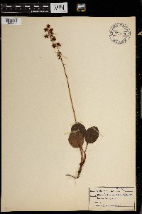 Pyrola asarifolia Michaux 0967935[1368506]F.W. Bieberdorf s.n.1941-00-00 United States, Wyoming, Yellowstone Park |
MIN:Plants | 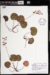 Pyrola asarifolia Michaux 972977[1398530]Lee, Michael MDL58922012-06-13 United States, Minnesota, Koochiching, On the banks of the Rainy River one mile east of Laurel, 12 miles west-southwest of International Falls; between the river and Highway 11., 48.5165989804 -93.6474014029, 332m |
Google Map
Google Maps is a web mapping service provided by Google that features a map that users can pan (by dragging the mouse) and zoom (by using the mouse wheel). Collection points are displayed as colored markers that when clicked on, displays the full information for that collection. When multiple species are queried (separated by semi-colons), different colored markers denote each individual species.