University of Minnesota
http://www.umn.edu/
612-625-5000
http://www.umn.edu/
612-625-5000
Minnesota Biodiversity Atlas
Bell Museum
Dataset: MIN-Plants
Taxa: Euphorbiaceae
Search Criteria: excluding cultivated/captive occurrences
Bell Museum plants | |
 MIN:Plants | 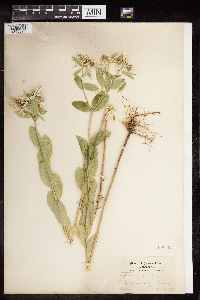 Euphorbia marginata Pursh 148617[1355599]Kenneth K. Mackenzie s.n.1897-08-22 United States, Missouri, Jackson |
MIN:Plants | 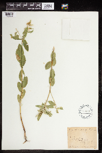 Euphorbia marginata Pursh 468813[1355602]B. Shimek s.n.1910-08-22 United States, Iowa, Lyon, NW part of Lyon Township |
MIN:Plants | 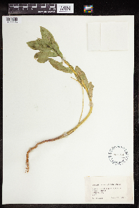 Euphorbia marginata Pursh 468814[1355603]B. Shimek s.n.1910-06-19 United States, Iowa, Monona, Loess ridge above village Grant Center, 42.15999 -96.000012 |
MIN:Plants | 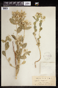 Euphorbia marginata Pursh 225930[1355604]Rev J.M.. Bates s.n.1907-09-02 United States, Nebraska, Red Cloud, 40.088902 -98.519505 |
MIN:Plants |  Euphorbia marginata Pursh 266833[1355605]Lycurgus R. Moyer s.n.1898-08-00 United States, Iowa, Missouri Valley |
MIN:Plants |  Euphorbia marginata Pursh 396454[1355606]S.C. Wadmond s.n.1938-09-10 United States, Wisconsin, Racine, Town of Mt Pleasant, County Line Rd |
MIN:Plants |  Euphorbia marginata Pursh 764297[1355607] s.n.1890-06-25 United States, Colorado, Marginata |
MIN:Plants |  Euphorbia marginata Pursh 964224[1355644]B.F. Bush 8791895-08-26 United States, Missouri, Dodson, 38.975006 -94.553011 |
MIN:Plants | 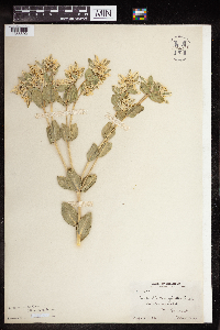 Euphorbia marginata Pursh 964225[1355592]Stevens, G.W. 18071913-08-02 United States, Oklahoma, Grant, Near Lamont., 36.690587 -97.556438 |
MIN:Plants | 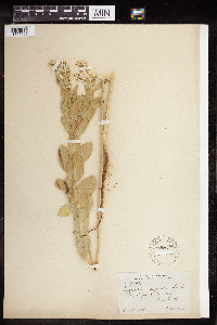 Euphorbia marginata Pursh 964226[1355601`]G.W. Stevens 2955.51913-10-11 United States, Oklahoma, Shattuck, 36.275873 -99.881232 |
MIN:Plants | 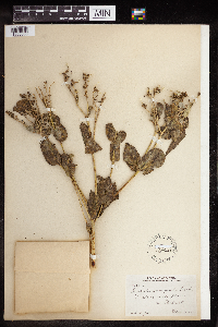 Euphorbia marginata Pursh 964227[1355600]Stevens, G.W. 29551913-10-11 United States, Oklahoma, Ellis, Near Shattuck., 36.275873 -99.881232 |
MIN:Plants | 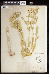 Euphorbia marginata Pursh 147859[1355598]Roxana Ferris 33111921-08-19 United States, Texas, Clay, Between Bellvue and Bowie, 33.595036 -97.92967 |
MIN:Plants |  Aleurites fordii Hemsley 679259[1351249]Elliott, J. 12031957-05-02 Japan, Nansei (Ryukyu) Islands, 1/4 mi up mountain road from forestry dormitory. Yona Forest; Kunigami-Gun; Okinawa-Shima;;;;, 26.661372 128.089599 |
MIN:Plants |  Aleurites fordii Hemsley 689136[1351245]Fischer, E.B. s.n. United States, Florida, University of Florida Campus-Florida., 29.651127 -82.348588 |
MIN:Plants |  689131[1352377] United States, Minnesota |
MIN:Plants |  689133[1352378] United States, Minnesota |
MIN:Plants |  251897[1352379]L.M. Umbach s.n.1898-10-06 United States, Illinois |
MIN:Plants |  588890[1352380]C.E. Munns 1201963-11-04 United States, Virginia |
MIN:Plants |  604152[1352381]C. Leland Rodgers 671641967-08-12 United States, South Carolina |
MIN:Plants |  149319[1352382]Legit A. H. Curtiss 2507 United States, Florida |
MIN:Plants |  149320[1352383]A.H. Curtiss 66931900-07-21 United States, Florida, Sumter |
MIN:Plants |  234547[1352384]J.W. Congdon s.n.1902-09-02 United States, California, San joaquin, Bouldin Island, 38.104086 -121.534675 |
MIN:Plants |  149318[1352385]M.E. Hyamo s.n. United States, North Carolina |
MIN:Plants |  535536[1352386] Honduras |
MIN:Plants |  225803[1352387] Puerto Rico |
MIN:Plants |  580739[1352388] Trinidad and Tobago |
MIN:Plants |  149322[1352389] Virgin Islands, U.s. |
MIN:Plants |  149321[1352390] |
MIN:Plants |  738275[1352391] Egypt |
MIN:Plants |  717258[1352392] Ethiopia |
MIN:Plants |  596062[1352393] Iran, Islamic Republic of |
MIN:Plants |  620649[1352394] French Polynesia |
MIN:Plants |  265106[1352395] Sri Lanka |
MIN:Plants |  270886[1352396] French Polynesia |
MIN:Plants |  270887[1352397] French Polynesia |
MIN:Plants |  149323[1352398] India |
MIN:Plants |  620584[1352399] French Polynesia |
MIN:Plants |  620586[1352400] French Polynesia |
MIN:Plants |  455784[1354549]Wheeler, Gerald 170191997-08-08 United States, Minnesota, Swift, Swift Co.; Ca. 6 mi. NNE of Benson, NW shore of Lake Hassel, at public water access; NE1/4 NW1/4 Sec. 9 T122N R39W (Benson 9). 122N 39W 9, 45.3904797 -95.5718166 |
MIN:Plants |  905510[1318615]Cholewa, A. 26062008-06-11 United States, Minnesota, Ramsey, Ramsey County, New Brighton, along US Highway 10/Long Lake Blvd from Rice Creek to rail crossing. T30N R23W Sec 17 NE1/4;;030N;23W;17, 45.0862905 -93.1983985 |
MIN:Plants | 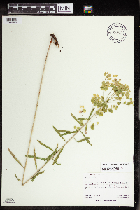 910723[1354503]Rowe, Erika ERR2602007-07-11 United States, Minnesota, Hubbard, Hubbard County...1 mile east of Cty Hwy 13; 2.7 miles SE of Nevis...T140N R33W SWNE S23;;140N;33W;23, 46.9288889 -94.8197222 |
MIN:Plants | 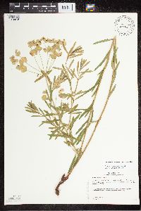 432260[1318616]Gerdes, D. Lawson 5582003-07-11 United States, Minnesota, Lake, Superior National Forest. T61N R09W S26SWSESW. Lake County...Superior National Forest. ~9.0 mi. east on FR377 (Tomahawk rd.) and ~1.6 miles southeast on FR173.. 061N 09W 26, 47.7370235 -91.4373425 |
MIN:Plants | 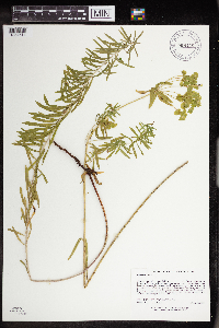 908426[1354514]Lee, Michael MDL41792005-09-15 United States, Minnesota, Becker, Becker County...Otter Tail River, four miles north of Frazee...immediately above the river just downstream from the Wannigan road bridge...T138N R40W NE1/4 of SW1/4 of NE1/4 Sec. 11. 138N 40W 11, 46.7811005 -95.7005368 |
MIN:Plants | 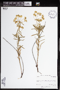 438813[1354518]Rowe, Erika ERR742005-06-03 United States, Minnesota, Becker, Becker County ... In and around parking area for Larson WPA, off of Township Road 488th ... 1/4NE 1/4SE S32 T138N R43W;Lage-Larson Wildlife Management Area;138N;43W;32, 46.7252119 -96.1430834 |
MIN:Plants | 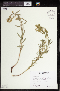 432453[1354522]Wheeler, Gerald 155981997-05-21 United States, Minnesota, Redwood, Redwood County...Ca. 2 mi. NW of North Redwood. Near summit of...slop...SE1/4 NW1/4 SW1/4 Sec. 13 T113N R36W (Delhi 13 );;113N;36W;13, 44.6053218 -95.1498365 |
MIN:Plants | 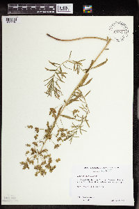 479732[1354510]Wheeler, Gerald 194451998-06-25 United States, Minnesota, Sibley, Sibley Co.; Ca. 8.5 mi. ESE of Green Isle, 4.5 mi. WSW of the jct. of Rte. 6 and Rte. 25, N of road (Rte. 6); N1/2 NE1/4 Sec. 5 T113N R25w. 113N 25W 5, 44.6189792 -93.8525311 |
MIN:Plants |  908387[1354515]Smith, Welby 245511994-07-06 United States, Minnesota, Sherburne, Sherburne County...Along the Blue Hill Trail in Sherburne National Wildlife Refuge...T 35N R 27W SW1/4 of NW1/4 of Sec 2;Sherburne National Wildlife Refuge;035N;27W;28, 45.4966667 -93.7111111 |
MIN:Plants |  361913[1354535]Lakela, Olga 37851940-07-29 United States, Minnesota, Saint Louis, RR lanes, St. Louis River bottoms ca 40th Ave W, Duluth;;N;;, 46.751996 -92.152062 |
MIN:Plants | 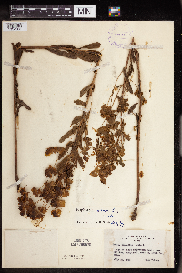 421314[1354563]Lakela, Olga 109311950-07-27 United States, Minnesota, Saint Louis, on Brimson Road, near Rollins, E St. Louis Co;;N;;, 47.276593 -91.86712 |
MIN:Plants | 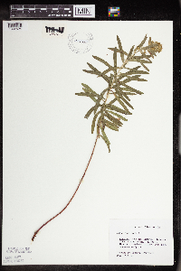 427428[1354524]Darveaux, B. s.n.1991-07-23 United States, Minnesota, Scott, Shakopee, Scott Co. Minnesota Valley Wildlife Refuge. Rt. 101 N.;Minnesota Valley National Wildlife Refuge;115N;23W;1, 44.7977388 -93.5304698 |
MIN:Plants | 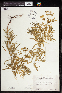 442136[1354537]Moore, John; Huff, N. 190431946-08-16 United States, Minnesota, Stevens, Pomme De Terre State Recreational Reserve;;;;, 45.580792 -95.88166 |
MIN:Plants | 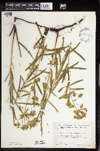 446138[1354532]Moore, John; Huff, N. 196651947-06-20 United States, Minnesota, Chippewa, Watson State Scenic Wayside Park, Chippewa Co.;;118N;41W;, 45.0217628 -95.797131 |
MIN:Plants | 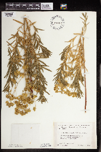 446598[1354531]Moore, John; Huff, N. 185021946-06-06 United States, Minnesota, Brown, Flandrau State Park;Flandrau State Park;N;;, 44.288542 -94.469979 |
MIN:Plants | 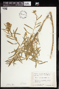 448406[1354536]Moore, John; et al. 176801945-07-10 United States, Minnesota, Jackson, Des Moines River 1/2 mi S of Petersburg;;;;, 43.50138 -94.90385 |
MIN:Plants | 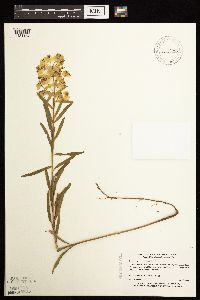 460759[1181164]Myhre, K. 39631993-06-27 United States, Minnesota, Pine, Pine Co.; Located 3 miles north of Mallard Lake; T 42N R 16W NE1/4 of NE1/4 of Sec 33;Saint Croix State Forest;042N;16W;33, 46.0772036 -92.3728233 |
MIN:Plants | 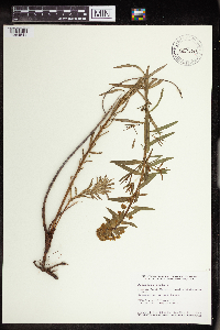 475567[1354541]Smith, Welby 151361989-05-21 United States, Minnesota, Mille Lacs, Kunkel Wildlife Management Area. Mille Lacs County...Kunkel State Wildlife Management Area, about 4.5 miles west of Princeton...SW1/4 SE1/4 section 26, T 36N R 27W. 036N 27W 26, 45.5763889 -93.6655556 |
MIN:Plants |  476268[1354525]Gerdes, Lynden; et al. 32551998-09-02 United States, Minnesota, Cook, T64N R03E S06SENENE. Cook Co.; Superior National Forest. BWCAW campsite on narrows between McFarland and Pine Lake.;Boundary Waters Canoe Area Wilderness / Superior National Forest;064N;01E;06, 48.0553452 -90.3721866 |
MIN:Plants |  476490[1181166]Gerdes, Lynden; et al. 32551998-09-02 United States, Minnesota, Cook, T64N R03E S06SENENE. Cook Co.; Superior National Forest. BWCAW campsite on narrows between McFarland and Pine Lake.;Boundary Waters Canoe Area Wilderness / Superior National Forest;064N;03E;06, 48.0553452 -90.3721866 |
MIN:Plants |  477909[1354550]Edlund, M. 15b1987-06-21 United States, Minnesota, Clearwater, Clearwater Co.; SW 1/4 SW 1/4, Sec. 26, T 144 N, R 36 W; in ditch next to S entrance to Lake Itasca Post Office off Hwy Clearwater Co.; SW 1/4 SW 1/4, Sec. 26, T 144 N, R 36 W; in ditch next to S entrance to Lake Itasca Post Office off Hwy 200.. 144N 36W 26, 47.2609128 -95.2015146 |
MIN:Plants |  488580[1354566]Moore, John 200721949-06-02 United States, Minnesota, Clay, 4 mi S of Hawley;;N;;, 46.822887 -96.316731 |
MIN:Plants | 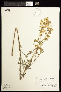 497570[1181162]Estes, Carol LL5381994-06-14 United States, Minnesota, Beltrami, Chippewa National Forest. Beltrami Co.; Drury Lake area near junciton of Chippewa National Forest roads 2213 and 2417; T 148N R 31W NE1/4 of NE1/4 Beltrami Co.; Drury Lake area near junciton of Chippewa National Forest roads 2213 and 2417; T 148N R 31W NE1/4 of NE1/4 of Sec 27. 148N 31W 27, 47.6055263 -94.5991578 |
MIN:Plants | 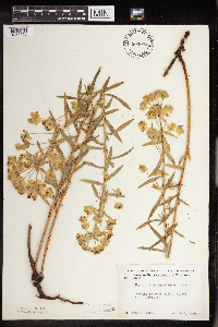 503078[1354556]Moore, John 205231950-06-05 United States, Minnesota, Big Stone, Ortonville;;N;;, 45.307343 -96.443406 |
MIN:Plants | 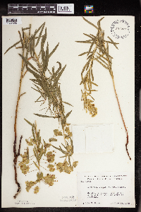 507222[1354558]Moore, John 206681950-06-20 United States, Minnesota, Martin, S end of Hall Lake S of Fairmont;;N;;, 43.611906 -94.469638 |
MIN:Plants | 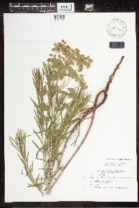 514796[1318612]Smith, Welby 187201991-06-07 United States, Minnesota, Todd, Todd Co.; about 3.5 mi SW of Motley; T133N R32W NW1/4 of NE1/4 of Sec 27;;133N;32W;27, 46.3088875 -94.7011108 |
MIN:Plants | 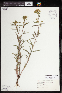 519289[1354506]Mursu, C. s.n.1997-00-00 United States, Minnesota, Sherburne, Sherburne National Wildlife Refuge; SENE 25-35-28;Sherburne National Wildlife Refuge;035N;28W;25, 45.494276 -93.7688166 |
MIN:Plants | 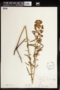 550748[1354527]Cotter, Shirley 14131950-06-03 United States, Minnesota, Ramsey, Ramsey Co.; Hidden Falls, S of Ford Plant on Mississippi River, St. Paul;Hidden Falls - Crosby Farm Regional Park;028N;23W;, 44.9051624 -93.1664625 |
MIN:Plants | 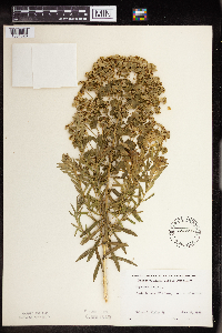 553696[1354526]Mielke, Walter 891958-06-28 United States, Minnesota, Itasca, near Hill Lake, 1 mi W of Marble;;N;;, 47.320492 -93.319889 |
MIN:Plants | 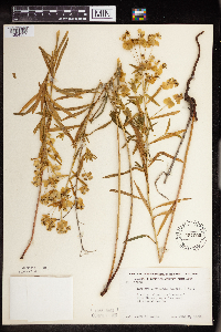 554005[1354557]Moore, John 225201955-06-02 United States, Minnesota, Renville, Renville Co.; banks of Hawk Creek, 4 1/2 mi W of Sacred Heart;;115N;28W;, 44.783859 -95.446681 |
MIN:Plants | 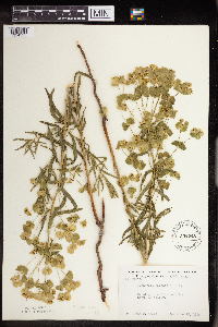 554248[1354555]Moore, John 229151956-06-13 United States, Minnesota, Clay, 5 mi N of Rollag;;N;;, 46.812342 -96.238118 |
MIN:Plants | 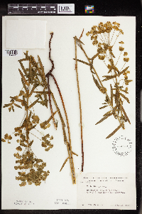 574553[1354561]Moore, John 246251959-06-16 United States, Minnesota, Pipestone, Pipestone Co. 1/2 mi north of Pipestone;;106N;46W;, 43.9797232 -96.367859 |
MIN:Plants | 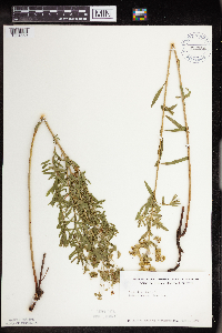 622280[1354559]Westkaemper, Remberta s.n.1971-07-01 United States, Minnesota, Stearns, Stearns Co.; Lake Henry;;123N;33W;, 45.46052 -94.796398 |
MIN:Plants | 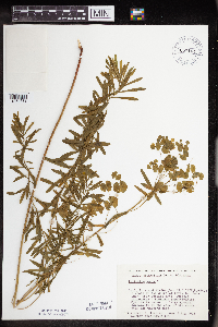 657104[1354538]Scanlan, M. 0011973-08-02 United States, Minnesota, Big Stone, stand BI-246 (S29, T122N, R45W) on the shore of Otrey L;;122N;45W;29, 45.3481407 -96.3334139 |
MIN:Plants | 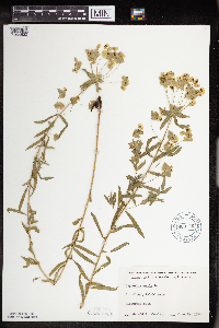 669746[1354530]Wheeler, Gerald s.n.1974-06-20 United States, Minnesota, Sherburne, St. Cloud, Talahi area;;N;;, 45.532473 -94.100159 |
MIN:Plants | 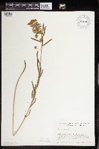 672611[1354533]Wheeler, Gerald s.n.1972-06-30 United States, Minnesota, Meeker, ca 1 mi SE of St. Cloud State College campus; in Talahi area;;N;;, 45.113174 -94.540298 |
MIN:Plants | 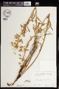 679089[1354562]Hanson, H. Theo 41-261941-05-25 United States, Minnesota, Hennepin, ca 2 mi E of Shakopee;;N;;, 44.829673 -93.486769 |
MIN:Plants | 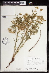 686954[1354565]Wheeler, Gerald; Glaser, Paul 13791977-05-21 United States, Minnesota, Itasca, coll site no 16. SE1/4 SW1/4 S13, T55N, R26W; ca 1.5 mi WNW of Grand Rapids, adjacent to hwy 63;;055N;26W;13, 47.2460564 -93.5869418 |
MIN:Plants | 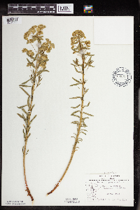 691013[1354528]Sperling, C. 1031976-05-22 United States, Minnesota, Douglas, 1 1/2 mi E of Garfield;;N;;, 45.94079 -95.460755 |
MIN:Plants | 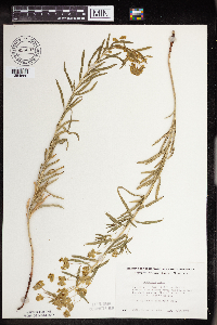 696637[1354560]Smith, Welby 8461978-05-28 United States, Minnesota, Wright, Wright Co.; T122N, R25W, N1/2 S32; between Mississippi River and Burlington Northern tracks, ca 3 mi NW of Monticello;;122N;25W;32, 45.3319075 -93.8600014 |
MIN:Plants | 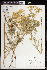 700789[1354529]Montgomery, Robert s.n.1974-06-09 United States, Minnesota, Ramsey, grounds of Rose Hill Nursery [Larpenteur and Eustis aves.], St. Paul;;029N;23W;, 44.9920769 -93.1663869 |
MIN:Plants | 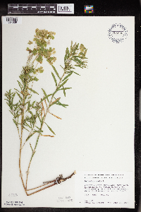 708996[1354539]Wheeler, Gerald 39841979-06-22 United States, Minnesota, Washington, William O'Brien State Park. William O'Brien State park; just N of Marine on St. Croix on Rte 95, rr embankment where tracks cross the ski trail, T32 William O'Brien State park; just N of Marine on St. Croix on Rte 95, rr embankment where tracks cross the ski trail, T32N, R19W, S31. 032N 19W 31, 45.2171528 -92.7641397 |
MIN:Plants | 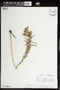 726308[1354512]Smith, Welby 24321980-06-11 United States, Minnesota, Otter Tail, T133N, R43W; SE1/4 SW1/4 NE1/4 S19; ca 1/4 mi due W of where Co Rd 116 crosses the Burlington Northern tracks;;133N;43W;19, 46.3185218 -96.1443156 |
MIN:Plants | 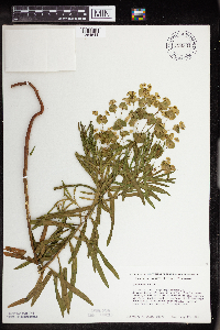 726344[1354544]Smith, Welby 33781980-08-17 United States, Minnesota, Wright, Wright Co. T119N, R25W, NW1/4 NE1/4 S15; between State hwy 55 and Soo Line RR tracks, ca 1/4 mi NW of the springs waysid Wright Co. T119N, R25W, NW1/4 NE1/4 S15; between State hwy 55 and Soo Line RR tracks, ca 1/4 mi NW of the springs wayside. 119N 25W 15, 45.1157732 -93.817185 |
MIN:Plants | 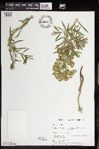 730879[1354564]Cross-Cella, J. 291980-06-02 United States, Minnesota, Clay, Audubon Prairie: 16.5 mi ESE of Moorhead, NW1/4 SW1/4 S32, T139N, R45W;Audubon Prairie, The Nature Conservancy;139N;45W;32, 46.8112046 -96.3982237 |
MIN:Plants | 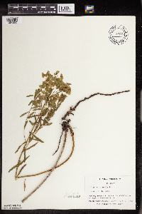 738702[1354552]Galatowitsch, S. 1571982-06-01 United States, Minnesota, Rice, Rice Co. Trout Lily Preserve: T110N, R20W, S1/2 NW1/4 SW1/4 of S20; part of NE1/4 SE1/4 S19;Cannon River Trout Lily Scientific Natural Area;110N;20W;, 44.3268919 -93.2219425 |
MIN:Plants |  739928[1354505]Converse, C. 8951982-05-29 United States, Minnesota, Douglas, Staffanson Prairie: T127N, R40W NW1/4 NE1/4 and NE1/4 NW1/4 S18;Staffanson Prairie, The Nature Conservancy;127N;40W;18, 45.810665 -95.7480052 |
MIN:Plants | 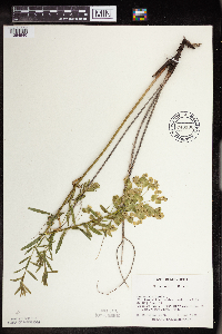 740196[1354540]Converse, C. 9261982-06-01 United States, Minnesota, Chippewa, Chippewa and Swift Cos. Chippewa Prairie: T119N, R43W, S12, W1/2 NE1/4;Chippewa Prairie, The Nature Conservancy;119N;43W;12, 45.1302134 -95.9905655 |
MIN:Plants | 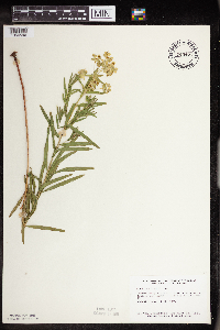 745477[1354546]Smith, Welby 45561981-06-28 United States, Minnesota, Wright, Wright County...Dickinson Springs State Wayside Park, about 5 mi SE of Buffalo on State hwy 55...NW1/4 NE1/4 Sec 15 T119N, R25W. 119N 25W 15, 45.1157732 -93.817185 |
MIN:Plants | 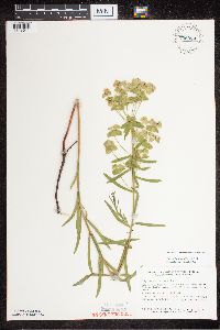 758089[1318611]Smith, Welby 66241982-07-03 United States, Minnesota, Renville, Renville Co.; between US Hwy 12 and the Chicago, Milwaukee, St. Paul and Pacific RR tracks, ca 2 1/2 mi W of Hector; NE1 Renville Co.; between US Hwy 12 and the Chicago, Milwaukee, St. Paul and Pacific RR tracks, ca 2 1/2 mi W of Hector; NE1/4 SW1/4 S24, T115N, R33W. 115N 33W 24, 44.7533404 -94.7622001 |
MIN:Plants | 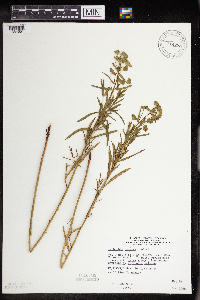 814753[1354551]Wheeler, Gerald 104311988-05-24 United States, Minnesota, Norman, ca 1 mi E of Twin Valley, Wild Rice River (N bank), near river, N1/2 SW1/4 S26, T144N, R44W (Wild Rice Twp);;144N;44W;26, 47.2598107 -96.2262021 |
MIN:Plants | 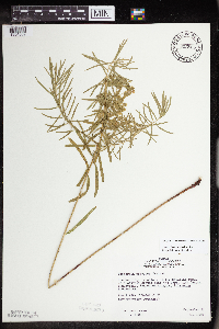 815865[1354509]Wheeler, Gerald 120271988-09-02 United States, Minnesota, Norman, Breckenridge (W side); Welles Memorial Park, near the park, NW1/4 S9, T132N, R47W (Breckenridge);;132N;47W;9, 46.2613098 -96.5847206 |
MIN:Plants | 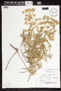 829396[1318614]Myhre, K. 23081992-06-22 United States, Minnesota, Cass, Cass Co. Located 1 mi SW of Turtle Lake; T141N R30W NW1/4 of NW1/4 of Sec 8;Chippewa National Forest / Leech Lake Indian Reservation;141N;30W;8, 47.0453276 -94.5026706 |
MIN:Plants | 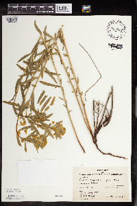 832418[1354534]Moyle, J. 37581941-05-14 United States, Minnesota, Hennepin, Hennepin Co. L. Minnetonka, Linwood;;N;;, 45.004579 -93.476877 |
MIN:Plants | 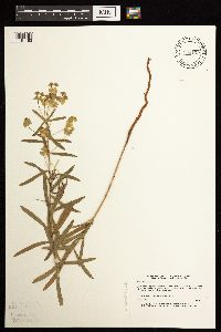 833109[1181163]Myhre, K. 24601992-06-29 United States, Minnesota, Cass, Cass Co. Located 1/2 mi NW of Hardy Lake; T133N R29W NW1/4 of NE1/4 of Sec.28;;133N;29W;28, 46.3039714 -94.3378993 |
MIN:Plants | 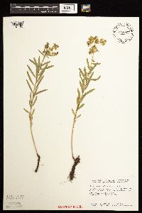 833735[1181165]Smith, Welby 141261988-05-30 United States, Minnesota, Lac Qui Parle, Lac Qui Parle County...About 5 mi W-NW of Montevideo; ravine that drains E into the Minnesota River. T117N R41W SW1/4 SE1/4 sec 5. 117N 41W 5, 44.9680556 -95.8305556 |
MIN:Plants | 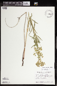 841008[1354507]Smith, Welby 127611987-05-23 United States, Minnesota, Dakota, Dakota Co. In the Minnesota Valley, about 1 mi E of Savage; NE1/4 SW1/4 sec.32, T27N R24W;;027N;24W;32, 44.7816658 -93.3174973 |
MIN:Plants | 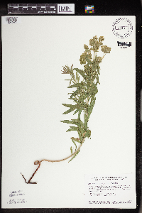 841322[1354545]Smith, Welby 144501988-07-01 United States, Minnesota, Nobles, Nobles County...About 1/2 mi E of Rushmore; right-of-way of the Chicago and Northwestern Railroad line...NW1/4 NE1/4 sec.29, T102N R41W. 102N 41W 29, 43.6155556 -95.7869444 |
MIN:Plants | 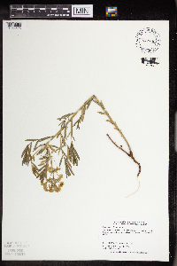 842786[1354523]Dahle, R. 940171994-05-19 United States, Minnesota, Nicollet, Swan Lake Wildlife Management Area. Nicollet Co. Swan Lake WMA (North Star Supplement), about 4 mi S of Nicollet. N of the gravel road and near the E bounda Nicollet Co. Swan Lake WMA (North Star Supplement), about 4 mi S of Nicollet. N of the gravel road and near the E boundary of the WMA. T109N R28W SE1/4 of SW1/4 of Sec 28.. 109N 28W 28, 44.2179992 -94.2001525 |
MIN:Plants | 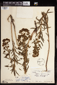 558264[1354553]Moore, John 236981958-05-25 United States, Minnesota, Blue Earth, Blue Earth County ... edge of sand pit 1 mile west of Cambria;;109N;29W;16, 44.2442134 -94.3238027 |
MIN:Plants | 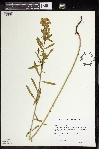 509741[1354521]Wheeler, Gerald 165151997-07-01 United States, Minnesota, Yellow Medicine, Yellow Medicine County ... Ca. 5 mi. NE of Echo; Swedes Forest SNA ... NE1/4 SW1/4 SE1/4 Sec. 12 T114N R38W;Swedes Forest Scientific Natural Area;114N;38W;12, 44.6940873 -95.3707359 |
MIN:Plants | 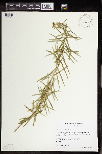 491063[1354520]Wheeler, Gerald 173351997-08-28 United States, Minnesota, Nicollet, Nicollet County ... Ca. 2.5 mi. NW of Courtland on Rte. 14, S of road ... N of quarry ... S1/2 NE1/4 SW1/4 Sec. 35 T110N R30W. 110N 30W 35, 44.2900788 -94.4018826 |
Google Map
Google Maps is a web mapping service provided by Google that features a map that users can pan (by dragging the mouse) and zoom (by using the mouse wheel). Collection points are displayed as colored markers that when clicked on, displays the full information for that collection. When multiple species are queried (separated by semi-colons), different colored markers denote each individual species.