University of Minnesota
http://www.umn.edu/
612-625-5000
http://www.umn.edu/
612-625-5000
Minnesota Biodiversity Atlas
Bell Museum
Dataset: MIN-Plants
Taxa: Fraxinus
Search Criteria: excluding cultivated/captive occurrences
Bell Museum plants | |
 MIN:Plants |  Fraxinus pennsylvanica Marshall 407289[1034001]Lakela, Olga 85831949-06-26 United States, Minnesota, Saint Louis, Terrace of White Iron Lake, E of Ely. St. Louis Co.;Superior National Forest;062N;12W;, 47.84605 -91.86099 |
MIN:Plants |  Fraxinus pennsylvanica Marshall 407375[1033792]Lakela, Olga 95191949-08-28 United States, Minnesota, Saint Louis, Lake Kabetogama near Park Point Resort. St. Louis Co.;Voyageurs National Park;;;, 48.48028 -93.055 |
MIN:Plants |  Fraxinus pennsylvanica Marshall 407586[1034002]Lakela, Olga 81921949-06-04 United States, Minnesota, Saint Louis, Prairie Lake, SW St. Louis Co.;;050N;20W;, 46.80928 -92.87068 |
MIN:Plants |  Fraxinus pennsylvanica Marshall 407635[1033769]Lakela, Olga 79831949-05-14 United States, Minnesota, Lake, Basswood Lake, The Hubachek Estate. Lake Co. [this was on Back Bay];Boundary Waters Canoe Area Wilderness / Superior National Forest;064N;10W;00, 48.075 -91.575 |
MIN:Plants |  Fraxinus pennsylvanica Marshall 412564[1033823]Moore, John; Moore, Marjorie 114241939-08-03 United States, Minnesota, Roseau, Roseau County ... On the S side of the Warroad River, Warroad;;163N;36W;, 48.90528 -95.31417 |
MIN:Plants |  Fraxinus pennsylvanica Marshall 416686[1034023]Lakela, Olga 85861949-06-26 United States, Minnesota, Saint Louis, Fall River, Winton. St. Louis Co.;Superior National Forest;063N;12W;, 47.93309 -91.86107 |
MIN:Plants |  Fraxinus pennsylvanica Marshall 419146[1033817]Ahlgren, Clifford 4741949-07-23 United States, Minnesota, Lake, Quetico-Superior Wilderness Research Center...Lake County ... Sec. 9 T64N R10W;Boundary Waters Canoe Area Wilderness / Superior National Forest;064N;10W;09, 48.03165 -91.61886 |
MIN:Plants |  Fraxinus pennsylvanica Marshall 420128[1033924]Lakela, Olga 117751950-08-25 United States, Minnesota, Saint Louis, St. Louis County ... Iron Lake, south of Crooked Lake;Boundary Waters Canoe Area Wilderness / Superior National Forest;066N;13W;00, 48.1945 -91.99516 |
MIN:Plants | 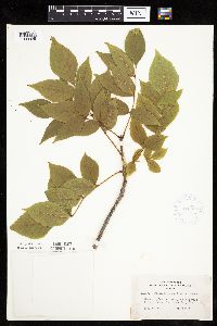 Fraxinus pennsylvanica Marshall 420891[1033925]Lakela, Olga 118081950-08-26 United States, Minnesota, Saint Louis, St. Louis County ... Lac La Croix, 8 miles west of Curtain Falls;Boundary Waters Canoe Area Wilderness / Superior National Forest;067N;13W;, 48.27662 -92.02661 |
MIN:Plants | 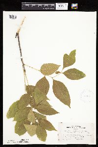 Fraxinus pennsylvanica Marshall 420965[1033997]Lakela, Olga 111821950-08-08 United States, Minnesota, Saint Louis, St. Louis County ... At the end of Savanna River Road, hwy 29, W of Floodwood;;051N;21W;, 46.89651 -92.99534 |
MIN:Plants | 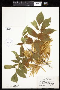 Fraxinus pennsylvanica Marshall 421043[1033906]Lakela, Olga 115431950-08-21 United States, Minnesota, Saint Louis, St. Louis County ... Crooked Lake, just above the Curtain Falls;Boundary Waters Canoe Area Wilderness / Superior National Forest;066N;12W;, 48.18679 -91.86997 |
MIN:Plants | 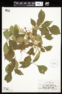 Fraxinus pennsylvanica Marshall 421085[1033998]Lakela, Olga 115441950-08-21 United States, Minnesota, Saint Louis, St. Louis County ... Crooked Lake, near Curtain Falls;Boundary Waters Canoe Area Wilderness / Superior National Forest;066N;12W;, 48.18679 -91.86997 |
MIN:Plants |  Fraxinus pennsylvanica Marshall 421142[1034042]Lakela, Olga 114031950-08-14 United States, Minnesota, Saint Louis, St. Louis County ... Park grounds at Fond du Lac;;048N;15W;, 46.65701 -92.25726 |
MIN:Plants |  Fraxinus pennsylvanica Marshall 421263[1033987]Lakela, Olga 120901950-09-06 United States, Minnesota, Saint Louis, St. Louis County ... Side Lake, at Sturgeon Lake, N of Hibbing;Sturgeon River State Forest;060N;21W;, 47.67592 -92.9968 |
MIN:Plants |  Fraxinus pennsylvanica Marshall 421665[1034025]Ahlgren, Clifford 11281950-08-22 United States, Minnesota, Saint Louis, St. Louis County ... Collected at Curtain Falls, Crooked Lake;Boundary Waters Canoe Area Wilderness / Superior National Forest;066N;12W;, 48.18679 -91.86997 |
MIN:Plants |  Fraxinus pennsylvanica Marshall 421666[1034005]Ahlgren, Clifford 11241950-08-22 United States, Minnesota, Saint Louis, St. Louis County ... Collected along portage trail 1/8 mi W of Curtain Falls, Crooked Lake;Boundary Waters Canoe Area Wilderness / Superior National Forest;066N;12W;, 48.18679 -91.86997 |
MIN:Plants | 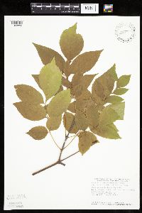 Fraxinus pennsylvanica Marshall 439409[1033856]Smith, Welby 164031989-09-06 United States, Minnesota, Benton, Benton County ... On the east bank of the Mississippi River in Rice ... NE1/4 NE1/4 sec.36, T38N R32W;;038N;32W;36, 45.748333 -94.2600021 |
MIN:Plants | 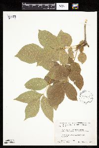 Fraxinus pennsylvanica Marshall 442236[1033904]Moore, John; Huff, N. 190901946-08-17 United States, Minnesota, Swift, in city park at Benson, Swift County;;121N;39W;, 45.28178 -95.56232 |
MIN:Plants | 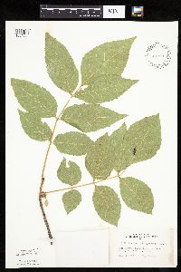 Fraxinus pennsylvanica Marshall 442385[1034056]Lakela, Olga 134021951-07-11 United States, Minnesota, Saint Louis, St. Louis County ... Rainy Lake, at Kettle Falls;Voyageurs National Park;070N;18W;, 48.49944 -92.63889 |
MIN:Plants | 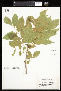 Fraxinus pennsylvanica Marshall 442456[1033910]Lakela, Olga 132311951-06-14 United States, Minnesota, Saint Louis, St. Louis County ... Rainy Lake at Kettle Falls;Voyageurs National Park;070N;18W;, 48.52144 -92.66536 |
MIN:Plants | 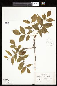 Fraxinus pennsylvanica Marshall 442717[1033911]Lakela, Olga 123931951-06-09 United States, Minnesota, Saint Louis, St. Louis County ... Floodwood River, 7 mi N of Floodwood;;052N;20W;, 46.98261 -92.86869 |
MIN:Plants | 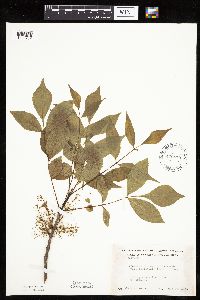 Fraxinus pennsylvanica Marshall 446070[1033767]Moore, John s.n.1945-06-16 United States, Minnesota, Kittson, Kittson County ... Along the river at Northcote;;162N;49W;, 48.84732 -96.99641 |
MIN:Plants | 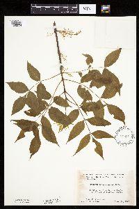 Fraxinus pennsylvanica Marshall 446181[1033774]Moore, John; et al. 173361945-06-20 United States, Minnesota, Red Lake, Red Lake County ... 1 mile east of Red Lake Falls;;151N;44W;, 47.8904077 -96.2881929 |
MIN:Plants | 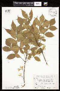 Fraxinus pennsylvanica Marshall 448461[1033912]Moore, John; Hall, Robert 164701944-06-11 United States, Minnesota, Lyon, Lyon County ... 1/2 mile west of Florence;;109N;43W;, 44.23993 -96.01826 |
MIN:Plants |  Fraxinus pennsylvanica Marshall 449011[1033851]Moore, John; Hall, Robert 167091944-08-01 United States, Minnesota, Aitkin, Aitkin County ... 1/2 mile east of Aitkin;;047N;27W;, 46.53305 -93.66791 |
MIN:Plants |  Fraxinus pennsylvanica Marshall 449128[1033766]Moore, John 169681945-05-30 United States, Minnesota, Watonwan, Watonwan County ... South fork of the Watonwan River, 5 miles east of St. James;;106N;31W;, 43.97858 -94.55427 |
MIN:Plants |  Fraxinus pennsylvanica Marshall 451240[1034049]Cotter, Shirley 6431948-08-00 United States, Minnesota, Clearwater, Itasca Park;Itasca State Park;143N;36W;, 47.19557 -95.2332161 |
MIN:Plants |  Fraxinus pennsylvanica Marshall 457939[1283384]Garrison, O. 139 United States, Minnesota, Upper Mississippi;;;;, 47.2181 -95.2072 |
MIN:Plants | 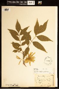 Fraxinus pennsylvanica Marshall 458034[1283386]Sandberg, John s.n.1890-06-00 United States, Minnesota, Chisago, [no further data];;;;, 45.5 -92.91 |
MIN:Plants | 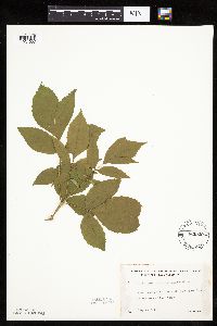 Fraxinus pennsylvanica Marshall 462920[1034057]Lakela, Olga 151901952-07-16 United States, Minnesota, Saint Louis, St. Louis County ... north shore of Kabetogama Lake, 3 miles west of Pine Island;Voyageurs National Park;070N;21W;, 48.53194 -93.0875 |
MIN:Plants | 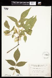 Fraxinus pennsylvanica Marshall 463412[1034027]Lakela, Olga 145501952-07-08 United States, Minnesota, Saint Louis, St. Louis County ... Shore of Fox Island, Rainy Lake, most northern part of the co.;Voyageurs National Park;071N;21W;, 48.625023 -92.960627 |
MIN:Plants | 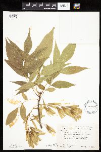 Fraxinus pennsylvanica Marshall 488734[1033831]Moore, John; Huff, N. 197651947-08-28 United States, Minnesota, Nicollet, Traverse Des Sioux State Historic Wayside Park, Nicollet Co.;;110N;26W;, 44.34861 -94.01722 |
MIN:Plants | 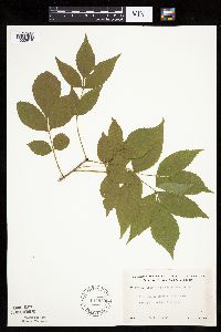 Fraxinus pennsylvanica Marshall 491879[1033818]Lakela, Olga 170561953-09-04 United States, Minnesota, Saint Louis, St. Louis County ... Trout River...at Trout Lake portage from Vermilion Lake;Boundary Waters Canoe Area Wilderness / Superior National Forest;063N;16W;24, 47.92435 -92.31937 |
MIN:Plants |  Fraxinus pennsylvanica Marshall 491882[1033975]Lakela, Olga 167181953-08-08 United States, Minnesota, Saint Louis, St. Louis County ... Lac La Croix E of Lac La Croix Resort;Boundary Waters Canoe Area Wilderness / Superior National Forest;;;, 48.34361 -92.12278 |
MIN:Plants |  Fraxinus pennsylvanica Marshall 500775[1033832]Moore, John 205011950-05-25 United States, Minnesota, Martin, Martin County ... Along the east shore of Big Twin Lake, 5 miles north of Sherburne;;103N;32W;, 43.72906 -94.7394 |
MIN:Plants |  Fraxinus pennsylvanica Marshall 524721[1033918]Larson, B. s.n.1929-10-01 United States, Minnesota, Hennepin, Hennepin County ... NE Minneapolis;;029N;24W;, 44.99193 -93.28815 |
MIN:Plants |  Fraxinus pennsylvanica Marshall 525911[1034061]Lakela, Olga 191731955-08-15 United States, Minnesota, Koochiching, Koochiching County ... Rainy Lake, Black Bay area;;071N;22W;, 48.56667 -93.15 |
MIN:Plants | 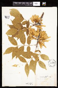 Fraxinus pennsylvanica Marshall 525956[1033862]Lakela, Olga 191851955-08-15 United States, Minnesota, Koochiching, Koochiching County ... Rainy Lake at Sha-Sha Resort;Voyageurs National Park;071N;22W;, 48.59639 -93.16028 |
MIN:Plants | 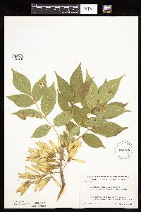 Fraxinus pennsylvanica Marshall 526402[1033919]Moore, John 212261951-08-07 United States, Minnesota, Wilkin, Wilkin County ... along the railroad 1 mile north of Doran;;132N;46W;, 46.23888 -96.44999 |
MIN:Plants | 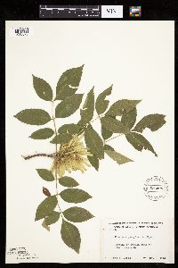 Fraxinus pennsylvanica Marshall 526426[1033870]Moore, John 212831951-08-09 United States, Minnesota, Douglas, Douglas County ... Lake Christina;;;;, 46.0925 -95.74389 |
MIN:Plants | 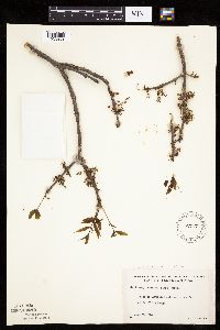 Fraxinus pennsylvanica Marshall 527171[1033869]Lakela, Olga 173261954-06-07 United States, Minnesota, Saint Louis, St. Louis County ... Vermilion Lake above the dam at Vermilion Lodge;Kabetogama State Forest;063N;17W;, 47.89167 -92.36667 |
MIN:Plants |  Fraxinus pennsylvanica Marshall 527439[1033844]Lakela, Olga 173921954-06-14 United States, Minnesota, Saint Louis, St. Louis County ... Floodwood River terrace, N of Floodwood, hwy 73;;052N;20W;, 46.92556 -92.90583 |
MIN:Plants |  Fraxinus pennsylvanica Marshall 532364[1033798]Lakela, Olga 199111956-06-19 United States, Minnesota, Saint Louis, St. Louis County ... Bank of St. Louis River below the bridge on Ox-Bow Road, west of Zim;;056N;18W;, 47.30694 -92.60306 |
MIN:Plants |  Fraxinus pennsylvanica Marshall 533078[1033927]Lakela, Olga 197761956-06-16 United States, Minnesota, Saint Louis, St. Louis County ... Seven Beaver Lake at the narrows;Superior National Forest;058N;12W;, 47.50124 -91.8543 |
MIN:Plants |  Fraxinus pennsylvanica Marshall 543597[1033889]Lakela, Olga 223521957-09-05 United States, Minnesota, Lake, Lake County ... White Iron Lake at Silver Rapids;Superior National Forest;063N;11W;32, 47.90389 -91.75528 |
MIN:Plants |  Fraxinus pennsylvanica Marshall 549800[1033860]Moore, John; et al. 222701954-09-22 United States, Minnesota, Lincoln, Lincoln County ... island at north-east end of Lake Benton;;110N;45W;25, 44.26111 -96.28722 |
MIN:Plants |  Fraxinus pennsylvanica Marshall 550763[1033814]Cotter, Shirley 20281951-07-20 United States, Minnesota, Ramsey, Knapp St. and Raymond Ave, St. Paul;;;;, 44.97451 -93.10089 |
MIN:Plants | 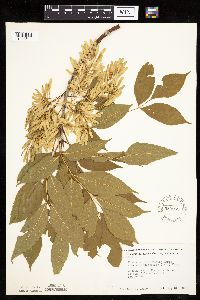 Fraxinus pennsylvanica Marshall 553962[1033841]Moore, John 224641955-05-31 United States, Minnesota, Sibley, Sibley County ... along the west shore of High Island Lake at New Auburn;;114N;28W;, 44.67361 -94.22944 |
MIN:Plants | 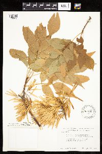 Fraxinus pennsylvanica Marshall 554206[1033915]Moore, John 230091956-09-13 United States, Minnesota, Clay, Clay County ... 3 miles east of Dilworth;;139N;47W;, 46.84796 -96.60971 |
MIN:Plants | 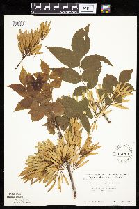 Fraxinus pennsylvanica Marshall 554268[1033887]Moore, John 232551957-06-17 United States, Minnesota, Martin, Martin County ... along the north shore of Iowa Lake;;101N;30W;, 43.50583 -94.46694 |
MIN:Plants |  Fraxinus pennsylvanica Marshall 554623[1034037]Moore, John 231301957-05-29 United States, Minnesota, Clay, Clay County ... in Barnesville;;137N;46W;00, 46.67411 -96.48376 |
MIN:Plants | 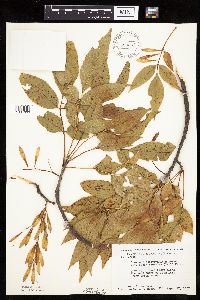 Fraxinus pennsylvanica Marshall 558367[1034063]Moore, John; Moore, Marjorie 235281957-09-17 United States, Minnesota, Anoka, Anoka County ... along the west shore of Fish Lake, Cedar Creek Forest;Cedar Creek National History Area;034N;23W;, 45.40424 -93.1723 |
MIN:Plants |  Fraxinus pennsylvanica Marshall 566523[1033807]Moore, John 239201958-06-14 United States, Minnesota, Kittson, Kittson County ... along the river at Hallock;;161N;49W;, 48.77444 -96.94611 |
MIN:Plants |  Fraxinus pennsylvanica Marshall 574397[1033922]Moore, John 245511959-06-03 United States, Minnesota, Blue Earth, Blue Earth County ... ravine 2 miles north of Mankato;;108N;26W;, 44.15257 -93.94876 |
MIN:Plants |  Fraxinus pennsylvanica Marshall 574561[1034010]Moore, John 246271959-06-16 United States, Minnesota, Pipestone, Pipestone County ... at Pipestone National Monument, 1 mile north of Pipestone.;Pipestone National Monument;106N;46W;, 43.97972 -96.36786 |
MIN:Plants |  Fraxinus pennsylvanica Marshall 583851[1033820]Gunderson, R. 4601961-07-18 United States, Minnesota, Washington, Washington County ... St. Croix River, 3 mi N of Stillwater, large island;Saint Croix National Riverway;030N;20W;, 45.09983 -92.80583 |
MIN:Plants | 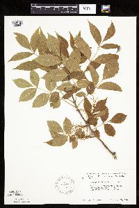 Fraxinus pennsylvanica Marshall 585304[1033941]Moore, John 259631962-05-29 United States, Minnesota, Pipestone, Pipestone County ... outcrop in north pasture at the Pipestone National Monument;Pipestone National Monument;106N;46W;, 43.97972 -96.36786 |
MIN:Plants | 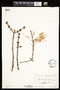 Fraxinus pennsylvanica Marshall 500752[1034065]Moore, John 204341950-05-11 United States, Minnesota, Big Stone, Big Stone County ... east shore of Lysing Lake;;;;, 45.41806 -96.42111 |
MIN:Plants | 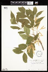 Fraxinus pennsylvanica Marshall 602207[1033893]Westkaemper, Remberta s.n.1965-05-00 United States, Minnesota, Stearns, Stearns County ... SBC [St. Benedict College] campus, St. Joseph;;124N;29W;, 45.55 -94.55 |
MIN:Plants | 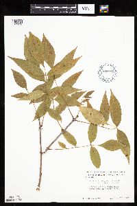 Fraxinus pennsylvanica Marshall 603751[1033836]Moore, John 270211966-10-13 United States, Minnesota, Houston, Houston County ... Mississippi River bank at Brownsville;Upper Mississippi National Wildlife Refuge;103N;04W;, 43.69417 -91.27972 |
MIN:Plants |  Fraxinus pennsylvanica Marshall 607235[1033964]Grafstrom, M. 941968-04-27 United States, Minnesota, Pine, Pine County. River edge ... T40N R18W NW1/4 Sec. 12;Saint Croix State Park;040N;18W;12, 45.97238 -92.54592 |
MIN:Plants |  Fraxinus pennsylvanica Marshall 616337[1033875]Moore, John; Moore, Marjorie 3701969-07-23 United States, Minnesota, Crow Wing, Crow Wing Natural History Area. Crow Wing County ... SW corner, NW1/4 Sec. 5, Garrison Twp.;Crow Wing Natural Area;044N;28W;5, 46.32316 -93.90458 |
MIN:Plants |  Fraxinus pennsylvanica Marshall 619124[1034021]Westkaemper, Remberta s.n.1970-06-00 United States, Minnesota, Stearns, Stearns County ... Meyer's Woods, St. Joseph;;124N;29W;, 45.54364 -94.32205 |
MIN:Plants |  Fraxinus pennsylvanica Marshall 631281[1033759]Richards, Donald; et al. 20871972-06-11 United States, Minnesota, Itasca, Itasca County...N shore of lake...Deer Lake, 18 mi NW of Grand Rapids;;057N;26W;00, 47.41644 -93.64325, 404m |
MIN:Plants |  Fraxinus pennsylvanica Marshall 670641[1033864]Heitlinger, M. 6501972-07-23 United States, Minnesota, McLeod, McLeod County ... Schaefer Prairie: SE1/4 Sec. 34, T115N, R29W ... NE edge of marshy depression in N-central prairie.;Schaefer Prairie, The Nature Conservancy;115N;29W;34, 44.72505 -94.30491 |
MIN:Plants |  Fraxinus pennsylvanica Marshall 670815[1033779]Heitlinger, M. 5751972-06-01 United States, Minnesota, McLeod, McLeod County ... Schaefer Prairie, along E bank of Buffalo Creek, W of cultivated fields ... SE1/4 Sec. 34 T115N R29W;Schaefer Prairie, The Nature Conservancy;115N;29W;34, 44.72505 -94.30491 |
MIN:Plants |  Fraxinus pennsylvanica Marshall 679011[1033816]Ownbey, Gerald 49011975-04-12 United States, Minnesota, Washington, Washington County ... Afton Hills Drive, 0.5 mi W of Afton Village;;028N;20W;, 44.90278 -92.79355 |
MIN:Plants |  Fraxinus pennsylvanica Marshall 680987[1033879]Swanson, Steven 4971975-06-13 United States, Minnesota, Winona, Mississippi River (Navigation Pool #8) ... Winona Co. Site 9 ... steep r.r. bank on W side of main channel.;Upper Mississippi National Wildlife Refuge;105N;04W;, 44.05 -91.63917 |
MIN:Plants | 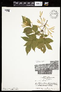 Fraxinus pennsylvanica Marshall 680999[1034038]Swanson, Steven 5471975-06-16 United States, Minnesota, Houston, Mississippi River (Navigation Pool #8) ... Houston County. Site 18, N end of forest;Upper Mississippi National Wildlife Refuge;;;, 43.65992 -91.34857 |
MIN:Plants | 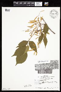 Fraxinus pennsylvanica Marshall 681103[1033876]Swanson, Steven 9231975-06-25 United States, Minnesota, Houston, Mississippi River (Navigation Pool #8) ... Houston County. Site 29.;Upper Mississippi National Wildlife Refuge;;;, 43.76316 -91.27441 |
MIN:Plants | 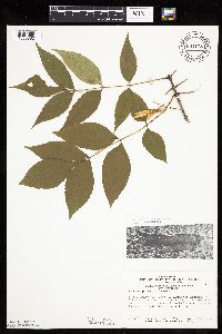 Fraxinus pennsylvanica Marshall 681178[1033882]Swanson, Steven 10231975-07-30 United States, Minnesota, Houston, Mississippi River Navigation Pool #8 ... Houston County. Site 71. N of forested island;Upper Mississippi National Wildlife Refuge;;;, 43.77109 -91.24695 |
MIN:Plants | 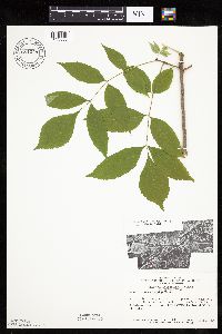 Fraxinus pennsylvanica Marshall 681248[1033880]Swanson, Steven 5291975-06-14 United States, Minnesota, Winona, Mississippi River (Navigation Pool #8) ... Winona Co. Site 11. A steep r.r. bank on W side of the main channel.;Upper Mississippi National Wildlife Refuge;105N;04W;, 43.87304 -91.33646 |
MIN:Plants |  Fraxinus pennsylvanica Marshall 681254[1033878]Swanson, Steven 8061975-06-23 United States, Minnesota, Houston, Mississippi River (Navigation Pool #8) ... Houston Co. Site 26, N tip of Pettibone Island disturbed by human habitation;Upper Mississippi National Wildlife Refuge;;;, 43.77903 -91.24146 |
MIN:Plants |  Fraxinus pennsylvanica Marshall 681416[1034040]Swanson, Steven 9991975-06-26 United States, Minnesota, Houston, Mississippi River (Navigation Pool #8) ... Houston Co. Site 37, along a dead-end slough in the delta of the Root River;Upper Mississippi National Wildlife Refuge;;;, 43.76194 -91.25167 |
MIN:Plants | 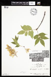 Fraxinus pennsylvanica Marshall 681424[1033877]Swanson, Steven 9521975-06-25 United States, Minnesota, Houston, Mississippi River (Navigation Pool #8) ... Houston Co, Site 30.;Upper Mississippi National Wildlife Refuge;;;, 43.77506 -91.24146 |
MIN:Plants |  Fraxinus pennsylvanica Marshall 681445[1034039]Swanson, Steven 8571975-06-23 United States, Minnesota, Houston, Mississippi River (Navigation Pool #8) ... Houston Co, Site 31, E side of forest bordered by a spit;Upper Mississippi National Wildlife Refuge;;;, 43.65794 -91.33209 |
MIN:Plants |  Fraxinus pennsylvanica Marshall 685195[1034041]Stassen, Carol 701977-06-14 United States, Minnesota, Lyon, Lyon County ... Camden State Park ... T110N R42W Sec. 5 NE1/4;Camden State Park;110N;42W;5, 44.36318 -95.92744 |
MIN:Plants | 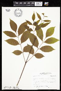 Fraxinus pennsylvanica Marshall 687208[1034000]Wheeler, Gerald; Glaser, Paul 16361977-06-06 United States, Minnesota, Itasca, Itasca County ... Coll. Site no. 35, ca. 11 mi SSW of Grand Rapids, situated between hwy 169 and the NW shore of Hennessey Lake; SE1/4 SW1/4 Sec. 13 T53N R26W. 053N 26W 13, 47.07836 -93.58174 |
MIN:Plants | 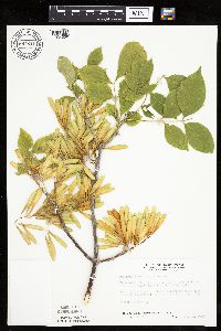 Fraxinus pennsylvanica Marshall 687811[1034036]Wheeler, Gerald; Glaser, Paul 22571977-07-24 United States, Minnesota, Itasca, Itasca County ...Coll. Site no. 144, ca. 4.5 mi NW of Grand Rapids, just N of hwy 6, close to the MP&L power plant NW1/4 SW1/4 Sec. 10 T55N R26W. 055N 26W 10, 47.26044 -93.6295 |
MIN:Plants | 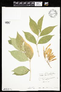 Fraxinus pennsylvanica Marshall 690636[1033785]Siemers, Ross 131977-06-13 United States, Minnesota, Stearns, Stearns County ... Rockville Tamarack Bog. Sec. 17, T123N, R29W.;Rockville Tamarack Bog;123N;29W;17, 45.46481 -94.35347 |
MIN:Plants | 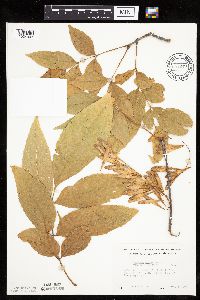 Fraxinus pennsylvanica Marshall 691249[1034003]Lightfoot, J. s.n.1977-09-24 United States, Minnesota, Pine, Pine County ... On the shore of Upper Pine Lake; SE1/4 NE1/4 Sec. 20 T43N R21W;;043N;21W;20, 46.19476 -93.0224 |
MIN:Plants |  Fraxinus pennsylvanica Marshall 696744[1034043]Smith, Welby 8271978-06-02 United States, Minnesota, Wright, Wright County ... between Clearwater Lake and state highway 24 ... T121N R27W SW1/4 Sec. 9;;121N;27W;9, 45.30094 -94.091601 |
MIN:Plants |  Fraxinus pennsylvanica Marshall 699749[1033867]Ziegler, S.; et al. 18451975-07-17 United States, Minnesota, Houston, Upper Mississippi National Wildlife Refuge. Houston County ... Island 23, Mississippi River mi. #700.7 ... T104N, R4W, Sec. 2. Large island on E side of main channel. 104N 04W 2, 43.83915 -91.28675, 197m |
MIN:Plants |  Fraxinus pennsylvanica Marshall 700848[1033885]Dorio, J. 2751977-06-20 United States, Minnesota, Morrison, Morrison County ... Lake Alexander, ca. 7 mi. N of Randall on Co. Rd. 6. T131N, R30W, Sec. 6.;Lake Alexander Preserve, The Nature Conservancy;131N;30W;6, 46.18707 -94.50623 |
MIN:Plants | 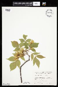 Fraxinus pennsylvanica Marshall 701391[1033883]Dorio, J. 4611977-07-07 United States, Minnesota, Morrison, Morrison County ... Sandhill Crane Meadow, 4.5 mi. W of Buckman on Hwy. 34. T39N, R31W, Sec. 3 & 4.;Crane Meadows National Wildlife Refuge;039N;31W;, 45.9044 -94.18858 |
MIN:Plants | 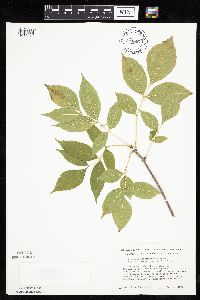 Fraxinus pennsylvanica Marshall 704667[1033916]Smith, Welby 17191979-08-16 United States, Minnesota, Wabasha, Wabasha County ... 400 meters due east of county road 84 ... T109N R9W SW1/4 NE1/4 Sec. 18;;109N;09W;18, 44.2436 -91.93911 |
MIN:Plants | 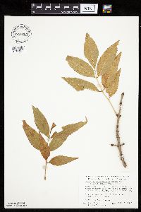 Fraxinus pennsylvanica Marshall 710017[1033764]Wheeler, Gerald 50471979-10-06 United States, Minnesota, Le Sueur, East Minnesota River Wildlife Management Area. Le Sueur County ... Approx. 1 mi SW of Kasota ... bluff overlooking the Minnesota River. High Lime Prairie. T109N, R26W, Sec. 6.. 109N 26W 6, 44.27458 -93.99847 |
MIN:Plants |  Fraxinus pennsylvanica Marshall 712120[1033974]Smith, Welby 18641979-08-25 United States, Minnesota, Wright, Wright County ... T122N, R26W, NE1/4 SW1/4 of Sec. 7. 0.2 mi. northeast of highway 75; 4 mi. southeast of its junction with Highway 24 in Clearwater. On the W bank of Fish Creek.. 122N 26W 7, 45.39473 -94.00784 |
MIN:Plants |  Fraxinus pennsylvanica Marshall 712144[1033973]Smith, Welby 18901979-09-13 United States, Minnesota, Wright, Lake Maria State Park. Wright County ... T 121N, R 26W, SE1/4 NE1/4 Sec. 10. Lake Marie [sic] State Park. About 1/4 mile northwest of the junction of county roads 111 and 39.. 121N 26W 10, 45.30396 -93.94289 |
MIN:Plants | 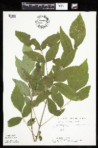 Fraxinus pennsylvanica Marshall 715675[1033888]Farrell, P. 1051979-07-12 United States, Minnesota, Beltrami, Beltrami County ... Pennington Orchid Bog SNA, 1 mi N of Pennington ... NW1/4 Sec. 3 T146N R30W;Leech Lake Indian Reservation / Pennington Bog Scientific Natural Area;146N;30W;3, 47.49162 -94.46904 |
MIN:Plants | 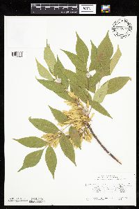 Fraxinus pennsylvanica Marshall 717091[1033940]Heitlinger, M. 7811975-07-23 United States, Minnesota, Anoka, Anoka Coynty ... Allison Savanna, collected in NE corner of tract ... N1/2 NE1/4 Sec. 2 T33N R23W;Helen Allison Savanna Scientific Natural Area;033N;23W;2, 45.3777 -93.17388 |
MIN:Plants | 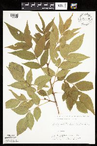 Fraxinus pennsylvanica Marshall 720143[1033929]Ottoson, S.; et al. 771979-07-03 United States, Minnesota, Agassiz Dunes Scientific Natural Area. Polk and Norman Counties...Agassiz Dunes...2 miles southwest of Fertile, Sec. 31,32, T149N [sic; should be T147], R44W; Sec. 5,6, T146N, R44W. , 47.5431 -96.25909 |
MIN:Plants | 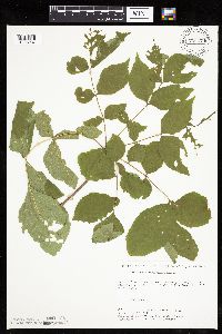 Fraxinus pennsylvanica Marshall 720174[1033937]Ottoson, S.; et al. 1051979-07-16 United States, Minnesota, Agassiz Dunes Scientific Natural Area. Polk and Norman Counties...Agassiz Dunes...2 miles southwest of Fertile, Sec. 31,32, T149N [sic; should be T147], R44W; Sec. 5,6, T146N, R44W. , 47.5431 -96.25909 |
MIN:Plants | 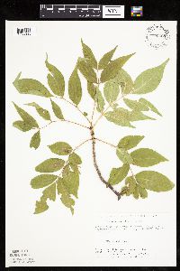 Fraxinus pennsylvanica Marshall 720208[1033935]Ottoson, S.; et al. 1041979-07-16 United States, Minnesota, Agassiz Dunes Scientific Natural Area. Polk and Norman Counties...Agassiz Dunes...2 miles southwest of Fertile, Sec. 31,32, T149N [sic; should be T147], R44W; Sec. 5,6, T146N, R44W., 47.5431 -96.25909 |
MIN:Plants | 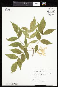 Fraxinus pennsylvanica Marshall 721230[1033936]Lustig, K. 5251979-06-25 United States, Minnesota, Sherburne, Clear Lake Scientific Natural Area. Sherburne County ... Clear Lake-Mississippi Scenic and Recreational River SNA, 12 mi SE of St. Cloud Sec. 14, 22, 23 T34N R30W. 034N 30W , 45.44634 -94.04378 |
MIN:Plants | 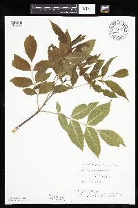 Fraxinus pennsylvanica Marshall 722802[1033855]Lustig, K. 4011979-06-06 United States, Minnesota, Anoka, Anoka County ... Boot Lake SNA: 18 mi. SE of Cambridge, Sec. 17, 18, 19, 20, T33N, R22W;Boot Lake Scientific Natural Area;033N;22W;00, 45.34797 -93.11302 |
MIN:Plants | 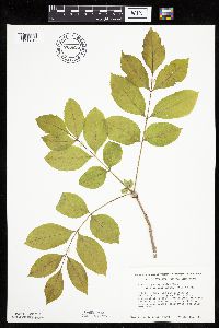 Fraxinus pennsylvanica Marshall 723695[1033819]Smith, Welby 20941980-05-12 United States, Minnesota, Wright, Wright County ... T118N, R26W, SE1/4 NE1/4 Sec. 24. South side of County Road 30 ... 4 miles southeast of Waverly.;;118N;26W;24, 45.01415 -93.90022 |
MIN:Plants | 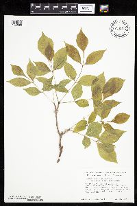 Fraxinus pennsylvanica Marshall 723937[1033892]Smith, Welby 21311980-05-12 United States, Minnesota, Wright, M Schmidt Crawford Woods Scientific Natural Area. Wright County ... near the southwest shore of Schmidt Lake, about 0.3 mi north of county highway 34, 4.5 mi east of its junction with state highway 55 near Buffalo ... T120N R25W NW1/4 SE1/4 Sec. 25. 120N 25W 25, 45.17276 -93.77599 |
MIN:Plants | 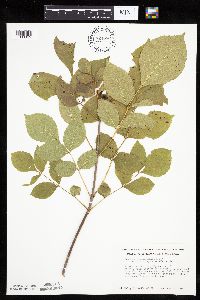 Fraxinus pennsylvanica Marshall 724086[1033965]Smith, Welby 32571980-08-10 United States, Minnesota, Wright, Wright County ... about 2 mi east of St. Michael, overlooking the Crow River ... T120N R23W NW1/4 NW1/4 Sec. 18;;120N;23W;18, 45.20686 -93.63196 |
MIN:Plants | 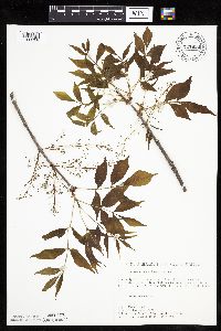 Fraxinus pennsylvanica Marshall 727656[1033768]Lustig, K. 3451979-05-31 United States, Minnesota, Sherburne, Mississippi River Islands Scientific Natural Area. Sherburne & Wright Cos. ...Mississippi Scenic and Recreational River Islands SNA, Mississippi River Islands between Monticello and Elk River. Sec. 2, 3, 4, T32N, R26, 27W; sec. 7. 9, 18, T121N, R23, 24W. 032N 26W 3, 45.29348 -93.55625 |
Google Map
Google Maps is a web mapping service provided by Google that features a map that users can pan (by dragging the mouse) and zoom (by using the mouse wheel). Collection points are displayed as colored markers that when clicked on, displays the full information for that collection. When multiple species are queried (separated by semi-colons), different colored markers denote each individual species.