University of Minnesota
http://www.umn.edu/
612-625-5000
http://www.umn.edu/
612-625-5000
Minnesota Biodiversity Atlas
Bell Museum
Dataset: MIN-Plants
Taxa: Fumariaceae
Search Criteria: excluding cultivated/captive occurrences
Bell Museum plants | |
 MIN:Plants | Corydalis micrantha var. micrantha (Engelmann ex A. Gray) A. Gray 116204[]Ainslie, G. 16761902-05-09 United States, Minnesota, Olmsted, Near mouth of Silver Creek, Rochester;;107N;14W;31, 44.0288458 -92.5484395 |
MIN:Plants | Corydalis micrantha var. micrantha (Engelmann ex A. Gray) A. Gray 116215[]Foote, Lewis s.n.1884-05-00 United States, Minnesota, Nobles, Worthington;;N;;, 43.619964 -95.596398 |
MIN:Plants | Corydalis micrantha var. micrantha (Engelmann ex A. Gray) A. Gray 116219[]Herrick, C. s.n.1878-04-00 United States, Minnesota, Hennepin, Minneapolis;;N;;, 44.97025 -93.263836 |
MIN:Plants | Corydalis micrantha var. micrantha (Engelmann ex A. Gray) A. Gray 116321[]Sheldon, Edmund S16031891-05-00 United States, Minnesota, Hennepin, Fort Snelling;Fort Snelling Military Reservation;028N;23W;, 44.888587 -93.194582 |
MIN:Plants | Corydalis micrantha var. micrantha (Engelmann ex A. Gray) A. Gray 116322[]Skinner, S. 2391902-00-00 United States, Minnesota, Murray, Lake Shetek; Heron Lake Region;;N;;, 44.118893 -95.690741 |
MIN:Plants | Corydalis micrantha var. micrantha (Engelmann ex A. Gray) A. Gray 116323[]Foote, Lewis s.n.1889-05-00 United States, Minnesota, Nobles, Worthington;;N;;, 43.619964 -95.596398 |
MIN:Plants | Corydalis micrantha var. micrantha (Engelmann ex A. Gray) A. Gray 116324[]Sheldon, Edmund S7941891-07-00 United States, Minnesota, Brown, Banks of the Cottonwood River, Sleepy Eye.;;110N;32W;, 44.282391 -94.687925 |
MIN:Plants | Corydalis micrantha var. micrantha (Engelmann ex A. Gray) A. Gray 116325[]Sheldon, Edmund s.n.1895-06-00 United States, Minnesota, Hennepin, Fort Snelling;Fort Snelling Military Reservation;028N;23W;, 44.888587 -93.194582 |
MIN:Plants | Corydalis micrantha var. micrantha (Engelmann ex A. Gray) A. Gray 116326[]Rosendahl, C.; Butters, F. 31931916-05-05 United States, Minnesota, Goodhue, Belle Creek Valley, near Vasa.;Dorer Memorial Hardwood State Forest;N;;, 44.511021 -92.738763 |
MIN:Plants | Corydalis micrantha var. micrantha (Engelmann ex A. Gray) A. Gray 263910[]Holzinger, John s.n.1901-06-00 United States, Minnesota, Winona, Winona Co.;;N;;, 43.98685 -91.779129 |
MIN:Plants | Corydalis micrantha var. micrantha (Engelmann ex A. Gray) A. Gray 349063[]Rosendahl, C.; et al. 30241935-05-19 United States, Minnesota, Pipestone, Roadside near 1st Huronian outcrop, Pipestone. Pipestone County;Pipestone National Monument;106N;46W;, 43.99969 -96.310335 |
MIN:Plants | Corydalis micrantha var. micrantha (Engelmann ex A. Gray) A. Gray 350604[]Lewis, Allison s.n.1937-05-15 United States, Minnesota, Goodhue, Welch;Dorer Memorial Hardwood State Forest;113N;16W;, 44.5683 -92.738532 |
MIN:Plants | Corydalis micrantha var. micrantha (Engelmann ex A. Gray) A. Gray 367539[]Moore, John; et al. 123721940-05-16 United States, Minnesota, Steele, N side of Owatonna. Steele Co.;;;;, 44.08389 -93.22583 |
MIN:Plants | Corydalis micrantha var. micrantha (Engelmann ex A. Gray) A. Gray 367637[]Moore, John; et al. 125061940-05-18 United States, Minnesota, Fillmore, Fillmore County...bluff of Iowa River, 2 mi NE of Granger.;;101N;11W;, 43.52267 -92.110534 |
MIN:Plants | Corydalis micrantha var. micrantha (Engelmann ex A. Gray) A. Gray 376221[]Dahl, A.; et al. s.n.1937-05-15 United States, Minnesota, Goodhue, Belle Creek Valley. Goodhue Co.;Dorer Memorial Hardwood State Forest;;;, 44.554192 -92.700527 |
MIN:Plants | Corydalis micrantha var. micrantha (Engelmann ex A. Gray) A. Gray 381199[]Moore, John; et al. 153341942-06-19 United States, Minnesota, Steele, Banks of the Straight River, bridge at N end of Medford, Medford Twp, NE1/4 Sec. 8. Steele Co.;;108N;20W;08, 44.1750581 -93.2566781 |
MIN:Plants | Corydalis micrantha var. micrantha (Engelmann ex A. Gray) A. Gray 507282[]Moore, John 207331950-06-22 United States, Minnesota, Faribault, Along the Blue Earth River at Blue Earth.;;N;;, 43.630202 -94.104859 |
MIN:Plants | Corydalis micrantha var. micrantha (Engelmann ex A. Gray) A. Gray 585551[]Moore, John; et al. 260301962-06-06 United States, Minnesota, Houston, Houston County...Along the r.r. at Reno.;Dorer Memorial Hardwood State Forest;;;, 43.601082 -91.275134 |
MIN:Plants | Corydalis micrantha var. micrantha (Engelmann ex A. Gray) A. Gray 602810[]Ownbey, Gerald 40301967-06-02 United States, Minnesota, Scott, Scott Co. Miriam Road, ca. 4 mi. S of Shakopee and ca. 2 mi. W of Rte. 169.;;115N;23W;, 44.743506 -93.599683 |
MIN:Plants | Corydalis micrantha var. micrantha (Engelmann ex A. Gray) A. Gray 603714[]Moore, John; et al. 268271966-05-29 United States, Minnesota, Blue Earth, Blue Earth County...Along the r.r, 3 mi. W of Mankato in Minneopa Creek Valley.;;;;, 44.149284 -94.086266 |
MIN:Plants | Corydalis micrantha var. micrantha (Engelmann ex A. Gray) A. Gray 603999[]Moore, John; Hsi, Yu-tseng [Eugene] 271951967-06-17 United States, Minnesota, Houston, Along the r.r. 1 1/2 mi. E of Houston.;;N;;, 43.763296 -91.538393 |
MIN:Plants | Corydalis micrantha var. micrantha (Engelmann ex A. Gray) A. Gray 611370[]Hsi, Yu-tseng [Eugene] 9921969-06-30 United States, Minnesota, Lyon, Along r.r. tracks, 3 1/2 mi. S of Marshall on Hwy. 59.;;N;;, 44.396214 -95.788354 |
MIN:Plants | Corydalis micrantha var. micrantha (Engelmann ex A. Gray) A. Gray 689615[]Lee, Grace Kwei 341967-05-20 United States, Minnesota, Scott, Ca. 4 mi. SW of Shakopee, W side of Rte. 169. Sec. 28, T115N, R23W.;;115N;23W;28, 44.7402167 -93.5923657 |
MIN:Plants | Corydalis micrantha var. micrantha (Engelmann ex A. Gray) A. Gray 729303[]Burrell, E.; et al. 15011981-05-23 United States, Minnesota, Renville, Renville County...1 1/2 mi. W of Morton. T113N, R35W, SW1/4 SE14 Sec. 26.;;113N;35W;26, 44.5634828 -95.0250514 |
MIN:Plants | Corydalis micrantha var. micrantha (Engelmann ex A. Gray) A. Gray 747544[]Nietering, E.; et al. 2291983-05-13 United States, Minnesota, Renville, Renville Co. Park #2, N of Delhi. NE1/4 SE1/4 Sec. 24, T114N, R37W. Just E of picnic shelter.;;114N;37W;24, 44.6616608 -95.2479996 |
MIN:Plants | Corydalis micrantha var. micrantha (Engelmann ex A. Gray) A. Gray 792842[]Converse, C. 23611983-06-10 United States, Minnesota, Dakota, Dakota Co. SE1/4 NW1/4 Sec. 11, T114N, R17W.;;114N;17W;11, 44.6949898 -92.8228357 |
MIN:Plants | 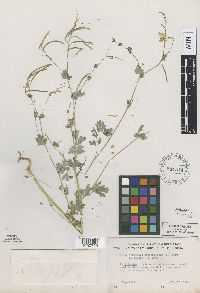 544574[1000723]Lakela, Olga 90221949-07-15 United States, Minnesota, Saint Louis, Rivard Road to Birch Lake, about 12 miles south of Ely, northeastern county;Superior National Forest;061N;12W;, 47.789558 -91.86434 |
MIN:Plants | 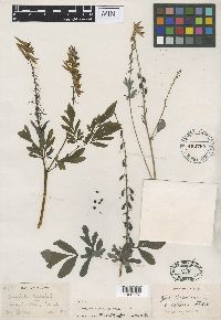 Corydalis allenii Fedde 452785[1000727]Allen, O.D. 1181855-06-00 United States, Washington, Cascade Mts. |
MIN:Plants | 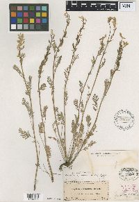 62885[1000726]Harvey, F.L. 1250000-00-00 United States, Arkansas, Northwest part |
MIN:Plants | 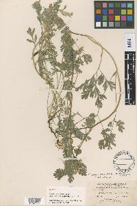 Corydalis macrorrhiza Fedde 116194[1000724]Baker, C.F. 3041898-07-03 United States, Colorado, Montezuma, West Mancos Canyon, 2743m |
MIN:Plants | 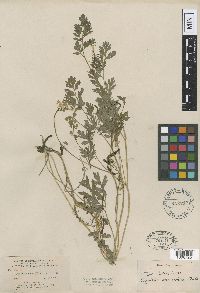 Corydalis macrorrhiza Fedde 452719[1000725]Baker, C.F. 3041898-07-03 United States, Colorado, Montezuma, West Mancos Canyon, 2743m |
MIN:Plants | 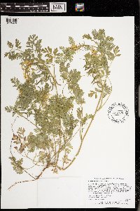 973375[1398928]Lee, Michael MDL58972012-06-14 United States, Minnesota, Lake, Rugged bedrock terrain north of the Fernberg Road, near the southwest end of Moose Lake, 15 miles east-southeast of Ely., 47.9742218154 -91.5297557868, 457m |
MIN:Plants | 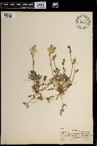 0968727[1391325]Hinds, R. s.n.1938-03-31 United States, Texas, College St. [Station] |
MIN:Plants | 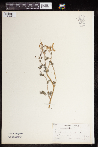 Capnoides sempervirens Borkh. 959744[1318048] 1858-00-00 United States, Massachusetts |
MIN:Plants | 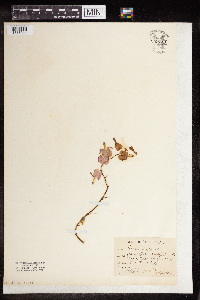 Dicentra spectabilis Lem. 959740[1318044] 1891-05-00 United States, Nebraska |
MIN:Plants | 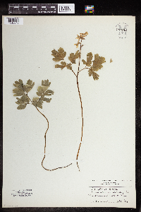 959742[1318046]Heimerl 1923-05-02 Austria |
MIN:Plants | 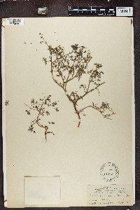 Fumaria parviflora Lam. 116697[1374860]Alice Carter Cook 1001897-02-00 Spain, Canary Islands: Guia |
MIN:Plants | 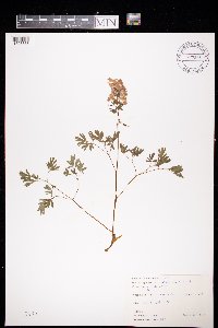 Corydalis solida (L.) Clairv. 972815[1398368]Janssens, J. 76/31976-04-09 Belgium, Hermeton-sur-Meuse |
Google Map
Google Maps is a web mapping service provided by Google that features a map that users can pan (by dragging the mouse) and zoom (by using the mouse wheel). Collection points are displayed as colored markers that when clicked on, displays the full information for that collection. When multiple species are queried (separated by semi-colons), different colored markers denote each individual species.