University of Minnesota
http://www.umn.edu/
612-625-5000
http://www.umn.edu/
612-625-5000
Minnesota Biodiversity Atlas
Bell Museum
Dataset: MIN-Plants
Taxa: Juncaceae
Search Criteria: excluding cultivated/captive occurrences
Bell Museum plants | |
 MIN:Plants |  Juncus NULL 390597[1186792] |
MIN:Plants |  Juncus NULL 355960[1186793] |
MIN:Plants |  Juncus NULL 588163[1186794] |
MIN:Plants |  Juncus NULL 540198[1186795] |
MIN:Plants | 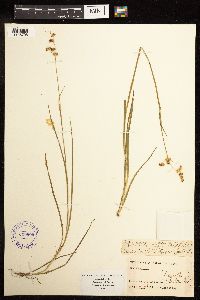 Juncus NULL 390600[1186796] |
MIN:Plants | 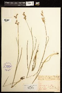 Juncus NULL 390601[1186797] |
MIN:Plants | 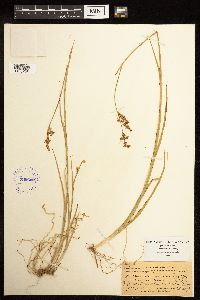 Juncus NULL 390602[1186798] |
MIN:Plants | 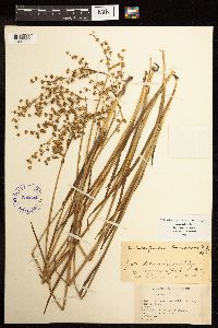 Juncus NULL 390604[1186799] |
MIN:Plants | 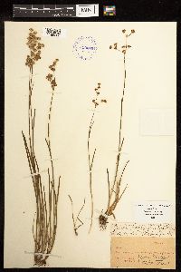 Juncus NULL 390603[1186800] |
MIN:Plants | 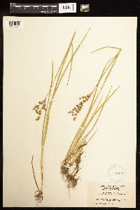 Juncus NULL 364669[1186801] |
MIN:Plants | 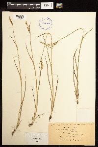 Juncus NULL 390598[1186802] |
MIN:Plants | 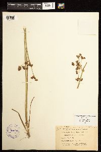 Juncus NULL 390599[1186803] |
MIN:Plants | 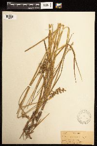 Juncus NULL 299224[1186804] |
MIN:Plants | 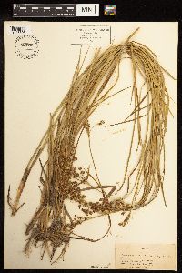 Juncus NULL 523746[1186805] |
MIN:Plants | 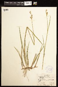 Juncus NULL 372956[1186806] |
MIN:Plants | 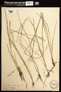 Juncus NULL 253960[1186807] |
MIN:Plants |  Juncus NULL 253961[1186808] |
MIN:Plants |  Juncus NULL 283128[1186809] |
MIN:Plants |  Juncus NULL 253955[1186810] |
MIN:Plants |  Juncus NULL 680551[1186812] |
MIN:Plants | 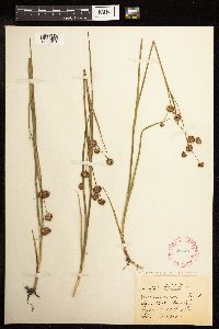 Juncus NULL 287487[1186813] |
MIN:Plants | 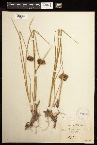 Juncus NULL 284814[1186814] |
MIN:Plants | 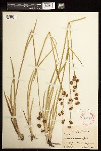 Juncus NULL 287825[1186815] |
MIN:Plants | 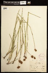 Juncus NULL 266258[1186816] |
MIN:Plants |  Juncus NULL 253956[1186817] |
MIN:Plants |  Juncus NULL 86331[1186818] |
MIN:Plants |  Juncus NULL 86332[1186819] |
MIN:Plants |  Juncus NULL 332727[1186820] |
MIN:Plants |  Juncus NULL 390590[1186821] |
MIN:Plants |  Juncus NULL 390592[1186822] |
MIN:Plants |  Juncus NULL 390591[1186823] |
MIN:Plants |  Juncus NULL 469421[1186824] |
MIN:Plants | 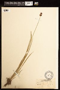 Juncus NULL 86751[1186825] |
MIN:Plants | 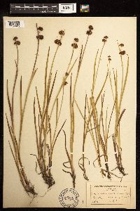 Juncus NULL 254059[1186826] |
MIN:Plants | 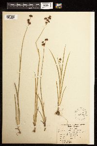 Juncus NULL 86746[1186827] |
MIN:Plants | 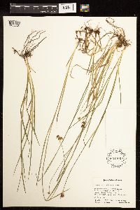 Juncus NULL 601400[1186828] |
MIN:Plants | 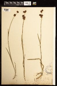 Juncus NULL 86756[1186829] |
MIN:Plants | 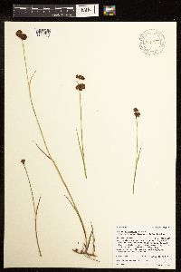 Juncus NULL 906536[1186830] |
MIN:Plants | 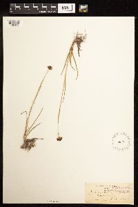 Juncus NULL 86039[1186856] |
MIN:Plants | 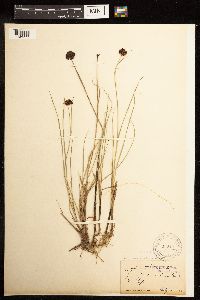 Juncus NULL 86046[1186857] |
MIN:Plants |  Juncus NULL 86045[1186858] |
MIN:Plants |  Juncus NULL 680354[1186859] |
MIN:Plants |  Juncus NULL 637657[1186860] |
MIN:Plants |  Juncus NULL 267134[1186925] |
MIN:Plants | 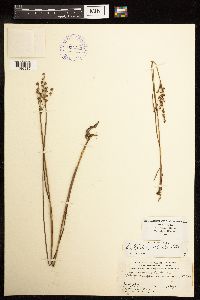 Juncus NULL 390743[1186985] |
MIN:Plants |  Juncus NULL 775440[1187042] |
MIN:Plants |  Juncus NULL 391226[1187043] |
MIN:Plants |  Juncus NULL 86713[1187044] |
MIN:Plants | 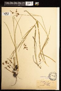 Juncus brunnescens NULL 85692[1186811]Metcalfe, O. B. 537 United States, New Mexico, Socorro |
MIN:Plants | 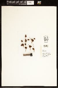 950320[1282966]Bright, R.C. 73-2911973-00-00 United States, Idaho, Franklin, Edge Creek, 1 mi south of divide to Frank Basin |
MIN:Plants | 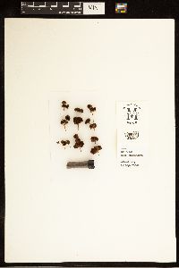 950319[1282964]Bright, R.C. 73-3041973-00-00 United States, Idaho, Franklin, Hillyard Spring |
MIN:Plants | 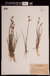 931838[1292105]Stork, H.E. s.n.1922-00-00 United States, Montana, Park, Yellowstone National Park |
MIN:Plants | 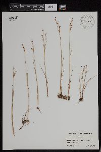 956352[1296222]Lawrence, D. B. s.n.1949-08-13 United States, Alaska, Glacier Bay National Monument. Station 49-3. [Glacier Bay National Park], 58.797428 -136.838127 |
MIN:Plants | 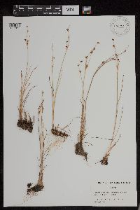 956284[1296158]Schoenike, R. 55-1051955-08-16 United States, Alaska, Glacier Bay National Monument. Cooper Station 26 [Glacier Bay National Park], 58.797428 -136.838127, 12m |
MIN:Plants | 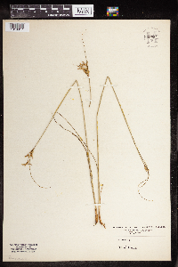 959994[1318317]Mowery, May 1928-07-03 United States, Massachusetts, Barnstable, Woods Hole and vicinity |
MIN:Plants | 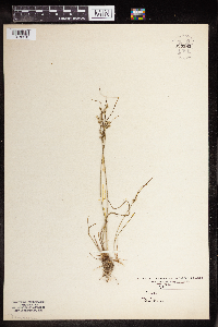 959993[1318318]Mowery, May 1928-07-03 United States, Massachusetts, woods hole and vicinity |
MIN:Plants |  0968677[1391262]Manhart, Warren 421938-07-00 United States, Wyoming, Yellowstone Park |
MIN:Plants |  0968749[1391347] s.n.1938-05-15 United States, Texas |
MIN:Plants |  968970[1391658]Walden, Jacob 01502020-09-01 United States, Minnesota, Lake, Superior National Forest. Approximately 11.1 km northwest of the intersection of Hwy 1 and New Tomahawk Rd and 2.8 km south of the intersection of Hwy 1 and Spruce Rd., 47.785608 -91.741008 |
MIN:Plants |  85478[1374748]Cook, Alice Carter 6291897-04-00 Spain, The Canary Islands. Gran Canaria: Aguiniguin |
MIN:Plants | 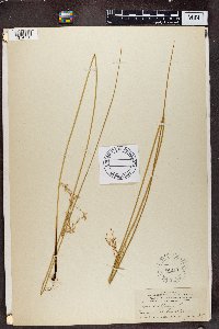 86010[1374750]Cook, Alice Carter 6401897-06-00 Spain, The Canary Islands. Gran Canaria: Los Laureles |
MIN:Plants | 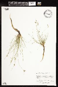 Juncus dudleyi Wiegand 453047[1138707]Lee, Michael MDL38662004-08-31 United States, Minnesota, Todd, Todd County...Along the Long Prairie River 1-1/2 miles south of Browerville...T130N R33W SE1/4 of SE1/4 of SE1/4 Sec. 17, NE1/4 of NE1/4 of NE1/4 Sec. [sic]. 130N 33W 17, 46.0704085 -94.865383 |
MIN:Plants | 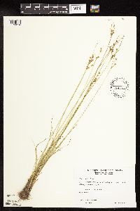 Juncus dudleyi Wiegand 509232[1138824]Wheeler, Gerald 194091998-06-24 United States, Minnesota, Sibley, Sibley County ... Ca. 2.1 mi. NNE of New Auburn; Schilling Lake ... SW1/4 Sec. 4 T114N R28W (New Auburn 4);;114N;28W;4, 44.7102738 -94.2032119 |
MIN:Plants | 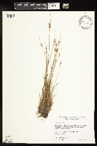 Juncus dudleyi Wiegand 509174[1138825]Wheeler, Gerald 189441998-06-06 United States, Minnesota, Redwood, Redwood County ... Ca. 4.5 mi. NE of Belview; 0.3 mi. E of jct. of Rte(s). 19 and 58 ... N1/2 NE1/4 NW1/4 Sec. 27 T114N R37W (Swedes Forest 27). 114N 37W 27 |
MIN:Plants | 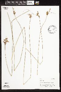 Juncus dudleyi Wiegand 499172[1106818]Mason, Harriet; Mason, Charles NSP98-901998-07-20 United States, Minnesota, Rice, North central of open area, north of western most electrical transformer. SW corner of section;Nerstrand Woods State Park;110N;19W;16, 44.334371 -93.1112031 |
MIN:Plants | 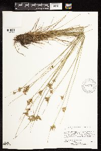 Juncus dudleyi Wiegand 911646[1138701]Lee, Michael MDL42512006-06-22 United States, Minnesota, Becker, White Earth Indian Reservation / White Earth State Forest. Becker County...6.5 miles north of Pine Point / Ponsford...eastern shore of Squaw (Wahbegon) Lake...T142N R37W NW1/4 of NE1/4 of SW1/4 Sec. 33...UTM: 5215784N 319625E. 142N 37W 33, 47.0716391 -95.371262 |
MIN:Plants | 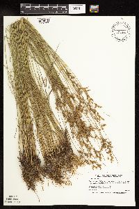 Juncus dudleyi Wiegand 477395[1138667]Smith, Welby 171141990-06-28 United States, Minnesota, Waseca, Waseca County ... at the north end of Buffalo Lake, about 3 miles south of Janesville ... T 107N R 24W NE1/4 of NE1/4 of Sec 20. 107N 24W 20, 44.0658333 -93.73 |
MIN:Plants | 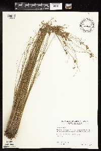 Juncus dudleyi Wiegand 426810[1138661]Wheeler, Gerald 204241999-08-21 United States, Minnesota, Carver, Ca. 2.5 mi. N of Waconia; N shore of Lake Waconia. S1/2 NE1/4 NW1/4 of section;;116N;25W;01, 44.8836705 -93.777773 |
MIN:Plants |  Juncus dudleyi Wiegand 499249[1106824]Mason, Harriet; Mason, Charles NSP98-951998-07-20 United States, Minnesota, Rice, Just south of the SW corner of former Lips tract. SW corner of section;Nerstrand Woods State Park;110N;19W;16, 44.334371 -93.1112031 |
MIN:Plants |  Juncus dudleyi Wiegand 489063[1138666]Gerdes, Lynden 37141999-08-03 United States, Minnesota, Cook, old Cook County gravel pit approximately .25 mile north of the northwestern corner of Aspen Lake. SESESE of sec.;Superior National Forest;064N;01E;03, 48.055437 -90.3068467 |
MIN:Plants |  Juncus dudleyi Wiegand 904391[1141773]Gerdes, Lynden 53322006-09-14 United States, Minnesota, Itasca, Bowstring State Forest. Sunken Lake, aproximately 6.51 miles SSE of Squaw Lake [town]. SESESE of secton;Chippewa National Forest / Leech Lake Indian Reservation;147N;27W;16, 47.5424966 -94.1064952 |
MIN:Plants |  Juncus dudleyi Wiegand 896949[1138662]Rowe, Erika ERR20060808042006-08-08 United States, Minnesota, Becker, Becker County...0.25 mile south of Cty Hwy 26; 0.5 miles west of Cty Hwy 27...east of Rice Lake...snowmobile trail... NWSW S09 T140N R40W. 140N 40W 9, 46.9544444 -95.7477778 |
MIN:Plants | Juncus dudleyi Wiegand 510775[]Wheeler, Gerald 173981997-08-29 United States, Minnesota, Renville, Birch Coulee State Memorial Park. Renville County ... Ca. 1.5 mi. NE of Morton, S of Rte. 2; Birch Coulee State Memorial Park; near bridge across creek ... NW1/4 NW1/4 Sec. 28 T113N R34W (Birch Cooley 28). 113N 34W 28, 44.5634035 -94.9442233 |
MIN:Plants | 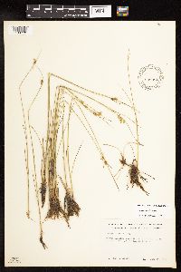 Juncus dudleyi Wiegand 539984[1138770]Tester, John s.n.1957-06-17 United States, Minnesota, Mahnomen, 3-4 miles w. and 1 mile s. of Waubun.;Waubun Prairie Wildlife Management Area / White Earth Indian Reservation;143N;42W;33, 47.1589041 -96.0074302 |
MIN:Plants | 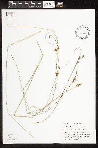 Juncus dudleyi Wiegand 425333[1106825]Mason, Harriet; Mason, Charles NSP98-1071998-07-28 United States, Minnesota, Rice, Releve N98-02. Just west of the SE most birdhouse. N of set of stakes and S of a slight draw draining to the NE. SW corner of section;Nerstrand Woods State Park;110N;19W;16, 44.334371 -93.1112031 |
MIN:Plants | 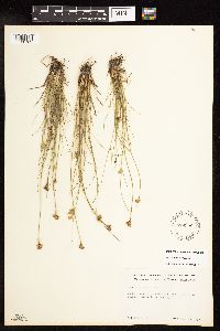 Juncus dudleyi Wiegand 539952[1138769]Tester, John s.n.1957-08-13 United States, Minnesota, Mahnomen, 3-4 miles w. and 1 mile s. of Waubun.;Waubun Prairie Wildlife Management Area / White Earth Indian Reservation;143N;42W;33, 47.1589041 -96.0074302 |
MIN:Plants | 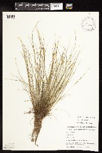 Juncus dudleyi Wiegand 491026[1138765]Capistrant, A. AMC11831998-05-11 United States, Minnesota, Ramsey, [no further data];;029N;22W;21, 44.9847716 -93.0559436 |
MIN:Plants |  Juncus dudleyi Wiegand 908363[1138823]Gerdes, Lynden 51712006-06-22 United States, Minnesota, Itasca, T53N R23W S32NWSESW. Itasca County, MN. Approximately 2.25 miles NW [actually NE] of Jacobson, MN on the north bank of the Mississippi River.. 053N 23W 32, 47.0342546 -93.2847728 |
MIN:Plants |  Juncus dudleyi Wiegand 909247[1138822]Gerdes, Lynden; et al. 56102008-07-25 United States, Minnesota, Saint Louis, T65N R12W S25 NESE St. Louis County ... Superior National Forest. Boundary Waters Canoe Area Wilderness. Fourtown Lake.;Boundary Waters Canoe Area Wilderness / Superior National Forest;065N;12W;25, 48.0836111 -91.8013889 |
MIN:Plants |  Juncus dudleyi Wiegand 491023[1138764]Capistrant, A. AMC13381998-05-11 United States, Minnesota, Ramsey, [no further data];;029N;22W;21, 44.9847716 -93.0559436 |
MIN:Plants |  Juncus dudleyi Wiegand 490526[1138717]Wheeler, Gerald 172631997-08-15 United States, Minnesota, Yellow Medicine, Yellow Medicine County...Ca. 7 mi. N of Echo on Rte. 67, 0.2 mi. E on Rte. A1...NE1/4 NW1/4 SW1/4 Sec. 34 T115N R38W (Sioux Agency 34 'N').. 115N 38W 34, 44.7230652 -95.411758 |
MIN:Plants | 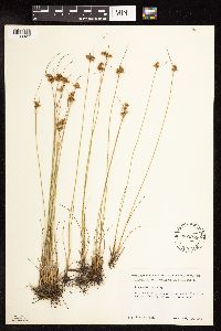 Juncus dudleyi Wiegand 552999[1138827]Tester, John s.n.1958-07-23 United States, Minnesota, Mahnomen, Mahnomen County...Waubun Prairie, 3-4 miles w. and 1 mile s. of Waubun. Sec. 33, T. 143N, R. 42W;Waubun Prairie Wildlife Management Area / White Earth Indian Reservation;143N;42W;33, 47.1589041 -96.0074302 |
MIN:Plants | 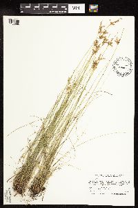 Juncus dudleyi Wiegand 480642[1138668]Smith, Welby 207311992-07-13 United States, Minnesota, Wadena, Wadena County ... Between Trunk Highway 10 and the Burlington Northern Railroad tracks, about one mile southeast of Verndale ... T 134N R 34W NW1/4 of SW1/4 of Sec 28. 134N 34W 28, 46.3869438 -94.9852753 |
MIN:Plants | 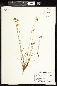 Juncus dudleyi Wiegand 432133[1138645]Myhre, K. 26661992-07-09 United States, Minnesota, Cass, Located on the southest shore of Moccasin Lake; NW1/4 of NW1/4 of sec;Chippewa National Forest;141N;29W;33, 46.9864071 -94.3557313 |
MIN:Plants | 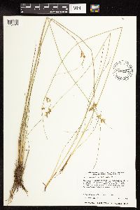 Juncus dudleyi Wiegand 433524[1138829]Harris, Fred 941391994-06-16 United States, Minnesota, Olmsted, Olmsted Co.; NE1/4 of SW1/4 of SW1/4 Sect. 7 T106N R11W;;106N;11W;7, 43.999079 -92.1891313 |
MIN:Plants |  Juncus dudleyi Wiegand 455334[1138663]Husveth, J. 95-39291995-09-07 United States, Minnesota, Houston, Houston Co. T104N R7W SW1/4 of the NE1/4 of S34; Root River;Dorer Memorial Hardwood State Forest;104N;07W;34, 43.7672852 -91.6606795 |
MIN:Plants |  Juncus dudleyi Wiegand 456682[1138772]Smith, Welby 209541992-07-15 United States, Minnesota, Marshall, Marshall Co.; In Old Mill State Park, about 11 miles east of Argyle; T 156N R 46W NW1/4 of SE1/4 of Sec 4;Old Mill State Park;156N;46W;4, 48.3602791 -96.5702744 |
MIN:Plants |  Juncus dudleyi Wiegand 456732[1138647]Smith, Welby 210171992-07-20 United States, Minnesota, Redwood, Redwood Co.; in the Minnesota River Valley, about 3 miles northest of Belview; T114N R37W NE1/4 of NW1/4 of Sec 27;;114N;37W;27, 44.6563873 -95.2977753 |
MIN:Plants |  Juncus dudleyi Wiegand 457087[1138654]Smith, Welby 189261991-06-25 United States, Minnesota, Todd, West Union Wildlife Management Area. Todd Co.; West Union State Wildlife Management Area, about 1.5 miles north-northwest of West Union (town); Todd Co.; West Union State Wildlife Management Area, about 1.5 miles north-northwest of West Union (town); T 127N R 35W NW1/4 of SW1/4 of Sec 9. 127N 35W 9, 45.8255539 -95.0955582 |
MIN:Plants | 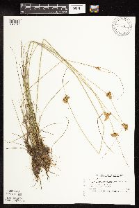 Juncus dudleyi Wiegand 473819[1138649]Smith, Welby 208301992-07-14 United States, Minnesota, Roseau, Roseau Co.; T 159N R 39W NW1/4 of NE1/4 of Sec 1;;159N;39W;1, 48.6236115 -95.6111145 |
MIN:Plants | 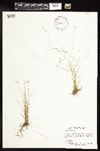 Juncus dudleyi Wiegand 475385[1138664]Delaney, B. 97125.11997-09-09 United States, Minnesota, Carlton, Carlton Co.; along the St. Louis River at the mouth of Crystal Creek; 1.5 miles north of Carlton.;;049N;16W;31, 46.6851199 -92.4175554 |
MIN:Plants | 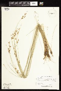 Juncus dudleyi Wiegand 476329[1138646]Lee, Michael MDL6441994-07-04 United States, Minnesota, Fillmore, Dorer Memorial Hardwood State Forest. Fillmore Co.; base of 150ft, southwest-facing bluff 2 1/3 miles north of Choice. Between township road and the bluff; T1 Fillmore Co.; base of 150ft, southwest-facing bluff 2 1/3 miles north of Choice. Between township road and the bluff; T103N R8W NESE 28. 103N 08W 28, 43.6953115 -91.8000012 |
MIN:Plants | 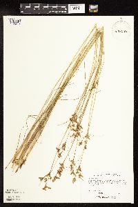 Juncus dudleyi Wiegand 476336[1138773]Lee, Michael MDL7461994-07-27 United States, Minnesota, Olmsted, Olmsted Co.; ditch along HWY 52 one mile north of Chatfield; T105N R11W SWSW 30;;105N;11W;30, 43.8687431 -92.1888796 |
MIN:Plants |  Juncus dudleyi Wiegand 477895[1138665]Husveth, J. 95-37171995-09-12 United States, Minnesota, Winona, Winona Co, T107N R10W SW1/4 of the SE1/4 of S6; North Fork of the Whitewater River;Whitewater Wildlife Management Area;107N;10W;6, 44.0995403 -92.0694287 |
MIN:Plants |  Juncus dudleyi Wiegand 519870[1138650]Smith, Welby 192991991-07-09 United States, Minnesota, Koochiching, Pine Island State Forest. Koochiching County...about 5 miles southwest of Big Falls. Along Hickes Ridge Road, about 0.5 mile north of US Highway 71. In an abandoned gravel pit...T 154N R 25W NE1/4 of SW1/4 of Sec 30. 154N 25W 30, 48.1272222 -93.8975 |
MIN:Plants |  Juncus dudleyi Wiegand 519991[1138653]Smith, Welby 170181990-06-25 United States, Minnesota, Steele, Aurora Wildlife Management Area. Steele County... Aurora State Wildlife Management Area. On the west side of U.S. Trunk Hwy 218, about 9 miles southeast of Owatonna...T 106N R 19W NE1/4 of NW1/4 of sec 28. 106N 19W 28, 43.9627778 -93.1175 |
MIN:Plants |  Juncus dudleyi Wiegand 787745[1138658]Smith, Welby 111381985-08-14 United States, Minnesota, Yellow Medicine, Sioux Nationalion Wildlife Management Area. Yellow Medicine Co.; Sioux Nation State Wildlife Management Area, about 8 miles west-southwest of Canby; NW1/4 SW1/4 sec Yellow Medicine Co.; Sioux Nation State Wildlife Management Area, about 8 miles west-southwest of Canby; NW1/4 SW1/4 section 17, T 114N R 46W. 114N 46W 17, 44.681835 -96.4295916 |
MIN:Plants |  Juncus dudleyi Wiegand 787750[1138657]Smith, Welby 111961985-08-15 United States, Minnesota, Cottonwood, Expandere Wildlife Management Area. Cottonwood Co.; Expandere State Wildlife Management Area, about 13 miles west-northwest of Windom; SE1/4 SW1/4 section 1 Cottonwood Co.; Expandere State Wildlife Management Area, about 13 miles west-northwest of Windom; SE1/4 SW1/4 section 1, T 105N R 38W. 105N 38W 1, 43.9275728 -95.3504697 |
MIN:Plants |  Juncus dudleyi Wiegand 829424[1138652]Delaney, B. 900561990-06-06 United States, Minnesota, Rice, Rice Co.; north shore of northeast island in Cedar Lake; SW 1/4 SW 1/4 sec. 25, T 110 N, R 22 W;;110N;22W;25, 44.294995 -93.43006 |
MIN:Plants |  Juncus dudleyi Wiegand 837344[1138670]Smith, Welby 175661990-07-31 United States, Minnesota, Morrison, Camp Ripley Military Reservation. Camp Ripley Miliatry Reservation. Morrison Co.; about 300 meters S-SW of Sylvan Dam; small lake; UTM: 393800E 5128300N T Camp Ripley Miliatry Reservation. Morrison Co.; about 300 meters S-SW of Sylvan Dam; small lake; UTM: 393800E 5128300N T 133N R 29W NE1/4 of SW1/4 of Sec 30. 133N 29W 30, 46.3011777 -94.3818202 |
Google Map
Google Maps is a web mapping service provided by Google that features a map that users can pan (by dragging the mouse) and zoom (by using the mouse wheel). Collection points are displayed as colored markers that when clicked on, displays the full information for that collection. When multiple species are queried (separated by semi-colons), different colored markers denote each individual species.