University of Minnesota
http://www.umn.edu/
612-625-5000
http://www.umn.edu/
612-625-5000
Minnesota Biodiversity Atlas
Bell Museum
Dataset: MIN-Plants
Taxa: Juncaginaceae
Search Criteria: excluding cultivated/captive occurrences
Bell Museum plants | |
 MIN:Plants | 818266[]Watson, W. 8641990-09-01 United States, Minnesota, Pope, Pope Co. T-124N R-39W SE1/4 SE1/4 Sec. 15;;124N;39W;15, 45.549458 -95.5519855 |
MIN:Plants | 828472[]Dana, R. 900681990-07-26 United States, Minnesota, Polk, Polk Co.; SW1/4 of NE1/4 Sec 22 T150N R39W;;150N;39W;22, 47.7989998 -95.6289978 |
MIN:Plants | 831684[]Harris, Fred 920811992-07-26 United States, Minnesota, Pennington, Pennington Co.; Glacial Lake Agassiz beach ridge; SE1/4 SE1/4 Sec 18 T153N R44W;;153N;44W;18, 48.071708 -96.3603171 |
MIN:Plants | 831693[]Harris, Fred 920931992-07-28 United States, Minnesota, Pennington, Pennington Co.; W-facing slope of Glacial Lake Agassiz beach ridge; NW1/4 NE1/4 Sec 7 T153N r44W;;153N;44W;7, 48.0863022 -96.3604327 |
MIN:Plants | 416134[]Spetzman, L. 41311950-07-17 United States, Alaska, Arctic North Slope...Noatak & Kugururok R.;Noatak National Preserve;;;, 67.9666667 -161.9166667, 152m |
MIN:Plants | 498932[]Whitfeld, T.J.S. 3672002-08-01 United States, Minnesota, Kandiyohi, Kandiyohi County ... 11 miles east of Willmar; 1 mile east of County Rd 4; 1/4 mile north of County Rd 23 ... T119N R33W SENESE21. 119N 33W 21, 45.121685 -94.817591 |
MIN:Plants | 479222[]Harris, Fred 961241996-07-10 United States, Minnesota, Le Sueur, Le Sueur Co.; 3.2 miles south of Ottawa; east side of Minnesota River Valley; T 110N R 26W NE1/4 of NE1/4 of Sec 14;;110N;26W;14, 44.3338469 -93.9190813 |
MIN:Plants | 483897[]Anderson, Craig 10202000-07-14 United States, Minnesota, Becker, Becker Co.; T142N R42W: 1/4 of NE1/4 of SE1/4 of Sect. 13 [sic];;142N;42W;13, 47.115314 -95.9444344 |
MIN:Plants | 910123[]Rowe, Erika ERR3132008-07-31 United States, Minnesota, Becker, Hubbard County...T140N R42W NWNW S36...1.75 miles west of State Hwy 59; 3.5 miles NE of Audubon and Hwy 10 [this location in Becker Co. not Hubbard]. 140N 42W 36, 46.905 -95.94 |
MIN:Plants | 459560[]Rowe, Erika ERR932005-07-06 United States, Minnesota, Becker, ~0.35 miles south of State Hwy 224; 1.35 miles SE of Ogema. 1/4 [sic] of SW /4 NW1/4 of section;Pederson Waterfowl Area / White Earth Indian Reservation;142N;41W;29, 47.085994 -95.9009975 |
MIN:Plants | 461255[]Wheeler, Gerald 189541998-06-06 United States, Minnesota, Redwood, Redwood Co.; Ca. 4.5 mi. NE of Belview, 0.3 mi. E of jct. of Rte. 19 and Rte. 58; N1/2 NE1/4 NW1/4 Sec. 27 T114N R37W (Swedes Forest 27). 114N 37W 27, 44.6505049 -95.2893316 |
MIN:Plants | 472662[]Lee, Michael MDL22191998-07-02 United States, Minnesota, Stearns, Stearns Co.; On west side of County Road 10 one mile north of Roscoe; T123N R32W S1/2 of NE1/4 of SE1/4 Sec. 24;;123N;32W;24, 45.4482855 -94.650389 |
MIN:Plants | 914298[]Lee, Michael MDL43482006-09-14 United States, Minnesota, Becker, Becker County...Along the Toad River nine miles northeast of Frazee...north and south of Dead Horse Creek...T138N R38W E1/2 of NW1/4 Sec. 7, W1/2 of NW1/4 of NE1/4 Sec. 18...UTM's: 5184052N 306698E; 5184469N 306589E; 5183214N 306831E. 138N 38W 0, 46.7673208 -95.5311561 |
MIN:Plants | 472652[]Lee, Michael; et al. MDL21861998-06-27 United States, Minnesota, Stearns, Stearns Co.; fen on the west side of State Hwy 4 along Stony Creek 1-3/4 miles north of Spring Hill; T124N R33W etc.;;124N;33W;16, 45.5499032 -94.8340586 |
MIN:Plants | 922901[]Rowe, Erika; et al. ERR4132008-07-17 United States, Minnesota, Mahnomen, Waubun Prairie Wildlife Management Area / White Earth Indian Reservation. T143N R41W SESE 30...Wauben WMA/Wauben WPA; 1 mile north of Becker Countyline; 1.8 miles east of State Hwy 59. 143N 41W 30, 47.1666667 -95.9158333 |
MIN:Plants | 922663[]et al.; Milburn, Scott SAM09-0052009-09-29 United States, Minnesota, Pennington, Easting 696,579 Northing 5,333,065. T 154N R 44W NE Sec 31 [this actually in Pennington Co.];;154N;44W;31, 48.1202778 -96.3583333 |
MIN:Plants | 922676[]et al.; Milburn, Scott SAM09-0062009-08-18 United States, Minnesota, Polk, Easting 747,523 Northing 5,298,117. T 150N R 39W NE Sec 30;;150N;39W;30, 47.786735 -95.693712 |
MIN:Plants | 929844[]Milburn, Scott SAM11-0182011-08-19 United States, Minnesota, Koochiching, Nine miles east of Upper Red Lake (140 meters east of the western section line). UTM: 402236E 5339148N. SWSW of section;Pine Island State Forest;155N;29W;36, 48.1980308 -94.3156442 |
MIN:Plants | 929483[]Milburn, Scott SAM10-0322010-08-01 United States, Minnesota, Polk, UTM(15): 297242E 5297378N. NWSW of section;;150N;39W;19, 47.7977611 -95.7076333 |
MIN:Plants | 132274[]Gockman, Otto 002002012-08-27 United States, Minnesota, Polk, (Main Unit). 2.3 miles northeast of Melvin. UTM: 248865E 5280968N. SW1/4 SW1/4 of section.;Burnham Wildlife Management Area;148N;45W;13, 47.6330556 -96.3430556 |
MIN:Plants | 936746[]Merchant, Steve 991691999-09-14 United States, Minnesota, Chippewa, Glacial River Warren Channel Bluff. NE1/4 of SE1/4 of SW1/4 of section;;117N;41W;02, 44.9711283 -95.7669927 |
MIN:Plants |  952921[1294957]Anderson, Derek S. 24692015-07-13 United States, Minnesota, Polk, 47.61 -96.35 |
MIN:Plants |  956229[1296058]Lawrence, D. B. s.n.1949-08-13 United States, Alaska, Glacier Bay National Monument. Station 49-3. [Glacier Bay National Park], 58.797428 -136.838127 |
MIN:Plants |  953226[1296001]Milburn, Scott A. SAM15-0062015-08-07 United States, Minnesota, Red Lake |
MIN:Plants |  943497[1296965]Smith, Welby R. 340572012-07-26 United States, Minnesota, Goodhue |
MIN:Plants | 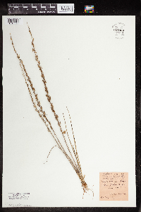 959986[1318325] 1939-10-12 United States, Wisconsin, Manitowac, Town, Two Rivers |
MIN:Plants | 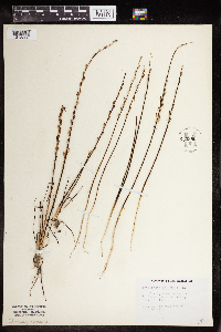 959985[1318326]Eyerdam, Walter 74441949-10-16 Air Field, Annette Island |
MIN:Plants | 960182[1318145]Anderson, Chel E. 24182017-07-02 United States, Minnesota, Koochiching, 10.5 mi east of Big Falls on CSAH 31. North 2.5 mi on Kooch Cty UT91 thru large peatland complex., 48.22 -93.59 |
MIN:Plants | 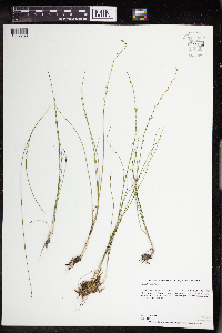 963623[1352238]Graham, Dustin R. DRJG1422018-06-21 United States, Minnesota, Big Stone, 1.5 miles south of Ortonville, MN., 45.27 -96.44, 982m |
MIN:Plants | 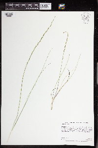 963606[1352221]Graham, Dustin R. DRJG872017-06-14 United States, Minnesota, Big Stone, Collection located ca. 8 km north-northwest of Ortonville, MN, on the northeast portion of Big Stone State Park., 45.38 -96.5, 1014m |
MIN:Plants |  973135[1398688]Lee, Michael MDL61612012-08-29 United States, Minnesota, Stearns, Rolling till plain along County Road 11, three miles north-northwest of St. Martin., 45.5437034397 -94.700378781, 363m |
MIN:Plants | Triglochin maritimum NULL 936295[]Smith, Welby R. 328622011-06-25 United States, Minnesota, Lake of the Woods, about 15 miles W-SW of Faunce. SW of NW of section;Red Lake State Wildlife Management Area;159N;36W;34, 48.5489667 -95.2725667 |
MIN:Plants |  949722[1297319]Smith, Welby R. 33585 United States, Minnesota, Goodhue |
MIN:Plants |  972930[1398483]Lee, Michael MDL55572011-06-08 United States, Minnesota, Clearwater, Red Lake Indian Reservation; Extensive wetland complex south of Fourth Lake - Butcher Knife Creek, nine miles north-northeast of Clearbrook., 47.80921633 -95.32711352, 364m |
MIN:Plants | Triglochin striata Ruiz & Pav. 296192[]Nash, A. 3099 United States, Wyoming, Park, Elk Park;Yellowstone National Park |
MIN:Plants | Triglochin striata Ruiz & Pav. 304808[]Nash, A. 3464 United States, Wyoming, Park, Elk Park;Yellowstone National Park |
MIN:Plants | Triglochin striata Ruiz & Pav. 337880[]Nash, A. 3465 United States, Wyoming, Park, Elk Park ;Yellowstone National Park |
MIN:Plants |  963808[1352716]Welby R Smith 354092015-09-06 United States, Minnesota, Redwood, In the Minnesota Valley, about 6.5 km (4 miles) NE of Belview. NE of NW of section, 44.65675 -95.2935278 |
MIN:Plants |  974297[1396661]Smith, Welby R WRS364782019-08-20 United States, Minnesota, Cottonwood, On the west side of Mountain Lake, about 330 meters from open water (and 3 m higher in elevation). In a calcareous fen on state/municipal property; pH averaging 7.4; specific conductivity 1300-1835., 43.948901 -94.963579 |
MIN:Plants |  974271[1396635]Smith, Welby R WRS364922019-08-20 United States, Minnesota, Cottonwood, Lake Augusta Waterfowl Production Area, about 6.5 km (4 miles) southwest of Jeffers at a heading of 215 degrees., 44.00921 -95.24225 |
MIN:Plants |  975896[1373449]Smith, Welby R WRS368742020-08-20 United States, Minnesota, Swift, About 6 km (3.7 miles) northwest of Sunburg., 45.39231 -95.28018 |
Google Map
Google Maps is a web mapping service provided by Google that features a map that users can pan (by dragging the mouse) and zoom (by using the mouse wheel). Collection points are displayed as colored markers that when clicked on, displays the full information for that collection. When multiple species are queried (separated by semi-colons), different colored markers denote each individual species.