University of Minnesota
http://www.umn.edu/
612-625-5000
http://www.umn.edu/
612-625-5000
Minnesota Biodiversity Atlas
Bell Museum
Dataset: MIN-Plants
Taxa: Lycopodiaceae
Search Criteria: excluding cultivated/captive occurrences
Bell Museum plants | |
 MIN:Plants |  Pseudolycopodiella caroliniana (L.) Holub 55111[1391882] United States, Florida |
MIN:Plants |  Pseudolycopodiella caroliniana (L.) Holub 55119[1391883] United States, New Jersey |
MIN:Plants |  Pseudolycopodiella caroliniana (L.) Holub 260888[1391884] United States, Georgia |
MIN:Plants |  Pseudolycopodiella caroliniana (L.) Holub 55118[1391885] United States, New Jersey |
MIN:Plants |  Pseudolycopodiella caroliniana (L.) Holub 388057[1391886] United States, New Jersey |
MIN:Plants |  Pseudolycopodiella caroliniana (L.) Holub 55115[1391887] United States, Alabama |
MIN:Plants |  Pseudolycopodiella caroliniana (L.) Holub 388056[1391888] United States, New Jersey |
MIN:Plants |  Pseudolycopodiella caroliniana (L.) Holub 680108[1391889] United States, Massachusetts |
MIN:Plants |  Pseudolycopodiella caroliniana (L.) Holub 759495[1391890] United States, Georgia |
MIN:Plants |  Pseudolycopodiella caroliniana (L.) Holub 55116[1391891] United States, Florida |
MIN:Plants |  Huperzia molongensis (Herter) Holub 476177[1338969]Franco, P. 1985-11-04 Colombia, Antioquia, Salgar, Cerro Plateau, 2700 - 3300m |
MIN:Plants |  Huperzia brongniartii (Spring) Trevis. 461447[1338970]Silverstone-Sopkin, Felipe A. 46511988-08-21 Colombia, Choco, San Jose del Palmar, Cerro del Torre, 2700 - 2800m |
MIN:Plants |  Huperzia phylicifolia (Desv.) Holub 902893[1338972]Lewis, Marko 397241991-09-03 Bolivia, Inquisivi, La Paz. Along a ravine joining the Rio Ocsalla, about 3 km down river from the Laguna Huara Huarani, 10 km N of Choquetanga., 3400 - 3600m |
MIN:Plants |  Huperzia phylicifolia (Desv.) Holub 928798[1338973]Killeen, T. 1992-06-06 Bolivia, Caballero, Santa Cruz, 15 to 25 km N of San Juan |
MIN:Plants |  Lycopodium crassum Humb. & Bonpl. ex Willd. 911959[1341607]Herrera, Gerardo 37201989-10-14 Costa Rica, Limon, Talamanca; Sabanas de Durika. Between the Rio Kuk and Cerro Karo, 9.436111 -83.319444, 2450m |
MIN:Plants |  Lycopodium fawcettii F.E. Lloyd & Underw. 521796[1341608]Shreve, Forrest s.n.1906-04-09 Jamaica, New Haven Gap, 18.111029 -77.301148 |
MIN:Plants |  Lycopodium tortum Sieber ex L.Underw. & F.Lloyd 619298[1341631]Burch, D. 13881969-06-01 Dominica, 1 mi E of Fresh Water Lake, 15.343183 -61.293131 |
MIN:Plants |  55098[1341672]Kindberg, N.C. s.n. Norway, Vårstien, 58.940162 5.68557 |
MIN:Plants |  354508[1341674]Lakela, Olga 33241939-08-19 Finland, Liinhamari on Arctic Ocean, 69.674219 31.333496 |
MIN:Plants |  341295[1341675]Montell, Ivstvs s.n.1916-08-30 Finland, Lappland, Kyrkahg[?], 67.683765 26.723307 |
MIN:Plants |  55100[1341676]Bagenholm, G. s.n.1896-08-00 Sweden, Hyectea and Langbro, 60.65 17.233333 |
MIN:Plants |  Lycopodium clavatum var. lagopus Laest. ex C. Hartm. 55194[1341703]Arrhenius, A. s.n.1880-08-21 Finland, Lappland, Petsikko, 69.433333 27.25 |
MIN:Plants |  Lycopodium clavatum var. lagopus Laest. ex C. Hartm. 55195[1341704]Wolf, Th. s.n.1906-08-25 Sweden, Joskmork, 62.455026 16.341057 |
MIN:Plants |  Lycopodium clavatum var. lagopus Laest. ex C. Hartm. 341293[1341705]Montell, Ivstvs s.n.1916-08-30 Finland, Nuonico[?], Kyrkaky, 64.470374 26.257813 |
MIN:Plants |  Lycopodium uliginosum Labill. 55456[1341788]Trail, J. s.n. United Kingdom, British Islands, 54.624567 -4.766472 |
MIN:Plants |  Lycopodium gnidioides L. f. 55251[1341794]MacOwan s.n.1876-02-00 South Africa, Boschberg, -31.967096 19.674986, 1494m |
MIN:Plants |  Lycopodium australianum Hert. 603282[1341802]Bogle, A.L. 4271962-02-10 Malaysia, North Borneo, Kambaranga. Mount Kinabalu, 6.05 116.533333 |
MIN:Plants |  Lycopodium billardieri Spring. 617214[1341803]Doore, L.A. 321.A1935-02-18 New Zealand, Stewart Island, Oban. One mile west of Oban, -47 168 |
MIN:Plants |  Lycopodium billardieri Spring. 571135[1341804]Willa, Eileen s.n.1958-11-00 New Zealand, Stewart Island; Halfmoon Bay, -47 168 |
MIN:Plants |  Lycopodium billardieri Spring. 617196[1341805]Doore, L.A. 2661935-01-27 New Zealand, Bay of Islands, 13 miles E of Russell on Whangarei road, 61m |
MIN:Plants |  Lycopodium billardieri Spring. 270591[1341806]Leland, B. 239B1910-01-00 New Zealand, Auckland, -36.75 174.583333 |
MIN:Plants |  Lycopodium billardieri Spring. 270590[1341807]Leland, B. 239B1910-01-00 New Zealand, Auckland, -36.75 174.583333 |
MIN:Plants |  Lycopodium billardieri Spring. 617230[1341808]Philson, P.J. 3371935-02-20 New Zealand, Stewart Island, 1.5 mi NW of Oban., -46.884643 168.110861 |
MIN:Plants |  Lycopodium densum Labill. 270509[1341843]Leland, B. 2061909-12-00 New Zealand, Auckland, -36.85 174.783333 |
MIN:Plants |  Lycopodium densum Labill. 270507[1341844]Leland, B. 2061909-12-00 New Zealand, Auckland, -36.85 174.783333 |
MIN:Plants |  Lycopodium densum Labill. 270327[1341845]Leland, B. 127B1909-11-00 New Zealand, Rotorua, -37.9035 176.204111 |
MIN:Plants |  Lycopodium densum Labill. 270508[1341846]Leland, B. 2061909-12-00 New Zealand, Auckland, -36.85 174.783333 |
MIN:Plants |  Lycopodium haeckelii Herter 289994[1341850]Grant, Martin L. 39101930-07-02 French Polynesia, Tahiti, Teahupoo District, Ronui, -17.846451 -149.266821 |
MIN:Plants |  Lycopodium haeckelii Herter 289995[1341851]Grant, Martin L. 37371930-06-05 French Polynesia, Tahiti, Mahina District, Aorai, 914m |
MIN:Plants |  Lycopodium haeckelii Herter 289993[1341852]Grant, Martin L. 41971930-09-21 French Polynesia, Tahiti, Papenoo District, Orofena, -17.583333 -149.433333, 686m |
MIN:Plants |  Lycopodium haeckelii Herter 289992[1341853]Grant, Martin L. 44111930-11-06 French Polynesia, Tahiti, Mahina District, Ahona, -17.5 -149.45, 1097m |
MIN:Plants |  Lycopodium hookeri Wall. ex Hook. & Grev. 220325[1341854]Lugger, Otto s.n.1879-07-16 Singapore |
MIN:Plants |  Lycopodium laterale R. Br. 617043[1341855]Nash, Arthur 2001934-01-00 Australia, New South Wales, Colloroy Beach outside of Sydney, -33.833 151.5 |
MIN:Plants |  Lycopodium pachystachyum Desv. ex Poir. 268052[1341856]Hapeman, H. s.n.1908-04-28 United States, Hawaii, Oahu, 21.4333 -157.9667 |
MIN:Plants |  Lycopodium phlegmarioides Gaudich. 289974[1341870]Grant, Martin L. 35511930-05-13 French Polynesia, Tahiti, Tahiti, Pare District. Diadem, -17.533333 -149.516667, 927m |
MIN:Plants |  Lycopodium phyllanthum Hook. & Arn. 417873[1341871]Forbes, C.N. s.n.1908-11-14 United States, Hawaii, K-[illegible] Mts between Punchem and Kaipanpan [?]; Oahu, 21.4333 -157.9667 |
MIN:Plants |  Lycopodium phyllanthum Hook. & Arn. 358340[1341872]Topping, D. L. 33451929-06-30 United States, Hawaii, Oahu, Waipio Ridge Trail, 610m |
MIN:Plants |  Lycopodium phyllanthum Hook. & Arn. 570359[1341873]Norris, R.E. s.n.1961-08-27 United States, Hawaii, Oahu, Poamoho Trail, 21.536667 -157.974167, 762m |
MIN:Plants |  Lycopodium phyllanthum Hook. & Arn. 55387[1341874]Heller, A.A. 21821895-07-18 United States, Hawaii, Kauai, between Hanapepe and Wahiawa Rivers, 21.964444 -159.521111 |
MIN:Plants |  Lycopodium phyllanthum Hook. & Arn. 368488[1341875]Topping, D. L. 261161923-05-20 United States, Hawaii, Oahu, Boroman Trail Ridge, 21.4333 -157.9667, 610m |
MIN:Plants |  Lycopodium polytrichoides Kaulf. 358341[1341876]Topping, D. L. 37481934-05-20 United States, Hawaii, Oahu, Kapalama, 21.4333 -157.9667 |
MIN:Plants |  Lycopodium polytrichoides Kaulf. 368491[1341877]Topping, D. L. 33601930-04-13 United States, Hawaii, Kamehameha[?], Oahu, 21.4333 -157.9667 |
MIN:Plants |  Lycopodium polytrichoides Kaulf. 417872[1341878]Forbes C.N. 2291912-07-00 United States, Hawaii, Molokai, Puie Kohkak[?], 21.1333 -157 |
MIN:Plants |  Lycopodium polytrichoides Kaulf. 376144[1341879]Bush, Will 38931938-09-16 United States, Hawaii, Puu Kukui, Maui, 20.8833 -156.5833 |
MIN:Plants |  Lycopodium ramulosum Kirk 576042[1341880]Willa, Eileen 561961-02-20 New Zealand, Stewart Island, 15m |
MIN:Plants |  Lycopodium ramulosum Kirk 617233[1341881]Doore, L.A. 3831935-02-28 New Zealand, Stewart Island, Half-moon Bay. Paterson Inlet on top of Pryse Peak, -46.933333 168, 350m |
MIN:Plants |  Lycopodium ribourtii Herter 289999[1341882]Grant, Martin L. 37121930-06-04 French Polynesia, Tahiti, Tahiti. Mahina District, Aorai, -17.55 -149.483333, 1216m |
MIN:Plants |  Lycopodium ribourtii Herter 290000[1341883]Grant, Martin L. 35521930-05-13 French Polynesia, Tahiti, Pare District, Diadem, -17.533333 -149.516667, 927m |
MIN:Plants |  Lycopodium ribourtii Herter 289998[1341884]Grant, Martin L. 39791930-08-05 French Polynesia, Tahiti, Tahiti, Teahupoo District. Vaiarava, -17.846451 -149.266821 |
MIN:Plants |  Lycopodium ribourtii Herter 289997[1341885]Grant, Martin L. 40631930-09-05 French Polynesia, Tahiti, Tahiti, Papenoo District. Farehape, -17.5 -149.416667, 251m |
MIN:Plants |  Lycopodium samoanum Herter 547187[1341886]Degener, Otto 139541941-01-02 Fiji, Uluinabathi Mt, Savu Savu. Vanua Levu, -19.1543 178.089882, 244m |
MIN:Plants |  Lycopodium samoanum Herter 386341[1341887]Degener, Otto 139591941-01-02 Fiji, Ulumabathi Mt, Savu Savu, Vanua Levu, 244m |
MIN:Plants |  Lycopodium squarrosum G. Forst. 289981[1341897]Grant, Martin L. 38661930-07-01 French Polynesia, Tahiti, Tahiti, Teahupoo District. Hututuna, -17.846451 -149.266821, 17m |
MIN:Plants |  Lycopodium squarrosum G. Forst. 289982[1341898]Grant, Martin L. 36711930-05-29 French Polynesia, Tahiti, Papara, Papara Valley, -17.831523 -149.479492, 472m |
MIN:Plants |  Lycopodium squarrosum G. Forst. 620703[1341899]Moore, John W. 5201927-01-11 French Polynesia, Society Islands, Raiatea, Raiatea, Avera Valley, -16.808914 -151.424481, 300m |
MIN:Plants |  Lycopodium varium R. Br. 270801[1341900]Leland, B. 3231910-02-00 New Zealand, Stewart Island, -47 167.833333 |
MIN:Plants |  Lycopodium varium R. Br. 270800[1341901]Leland, B. 3231910-02-00 New Zealand, Stewart Island, -47 167.833333 |
MIN:Plants |  Lycopodium volubile G. Forst. 603283[1341908]Kaul, Robert B. 20611962-02-12 Malaysia, Borneo, West Coastal Division, Paka Cave, Mount Kinabalu, 6.066667 116.55, 2880m |
MIN:Plants |  Lycopodium volubile G. Forst. 349128[1341909]Topping, D. L. 12081909-02-02 Philippines, Mt. Tonglon, Benguet, Luzon, 16.640743 121.918976 |
MIN:Plants |  Lycopodium volubile G. Forst. 290010[1341910]Grant, Martin L. 37701930-06-06 French Polynesia, Tahiti, Mahina District, Aorai, -17.55 -149.483333, 1461m |
MIN:Plants |  Lycopodium volubile G. Forst. 617182[1341911]T.T. Earle 3081935-02-16 New Zealand, Stewart Island, 1.5 mi NW of Oban. On "bush road" to Horseshoe Bay on S side of road, -46.884643 168.110861 |
MIN:Plants |  Lycopodium volubile G. Forst. 290011[1341912]Grant, Martin L. 37221930-06-04 French Polynesia, Tahiti, Mahina District, Aorai, -17.55 -149.483333, 953m |
MIN:Plants |  Lycopodium volubile G. Forst. 290009[1341913]Grant, Martin L. 37921930-06-07 French Polynesia, Tahiti, Mahina District, Aorai summit, -17.55 -149.483333, 2063m |
MIN:Plants |  Lycopodium volubile G. Forst. 521933[1341914]Armstrong, Mrs. C.C. s.n.1887-00-00 New Zealand, Vicinity of Dunedin, -45.866667 170.5 |
MIN:Plants |  Lycopodium volubile G. Forst. 270339[1341915]Leland, B. 1351909-11-00 New Zealand, Whakarewarewa, -38.166667 176.266667 |
MIN:Plants |  Lycopodium volubile G. Forst. 270338[1341916]Leland, B. 1351909-11-00 New Zealand, Whakarewarewa, -38.166667 176.266667 |
MIN:Plants | 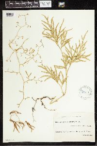 Lycopodium volubile G. Forst. 270341[1341917]Leland, B. 1351909-11-00 New Zealand, Whakarewarewa, -38.166667 176.266667 |
MIN:Plants | 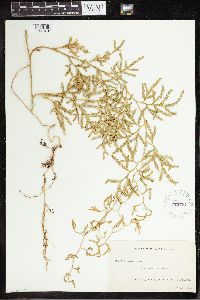 Lycopodium volubile G. Forst. 270774[1341918]Leland, B. 3121910-02-00 New Zealand, Stewart Island, -47 167.833333 |
MIN:Plants | 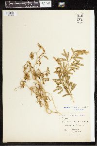 Lycopodium volubile G. Forst. 55459[1341919]Cockayne, L. 54371901-01-00 New Zealand, Chatham Island, -43.916667 -176.5 |
MIN:Plants | 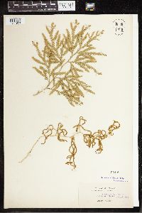 Lycopodium volubile G. Forst. 55460[1341920]Armstrong, Mrs. C.C. s.n.1887-00-00 New Zealand, Vicinity of Dunedin, -45.866667 170.5 |
MIN:Plants |  Lycopodium volubile G. Forst. 270340[1341921]Leland, B. 1351909-11-00 New Zealand, Whakarewarewa, -38.166667 176.266667 |
MIN:Plants |  Lycopodium volubile G. Forst. 270775[1341922]Leland, B. 3121910-02-00 New Zealand, Stewart Island, -47 167.833333 |
MIN:Plants |  Diphasiastrum angustiramosum (Alderw.) Holub 609271[1341842]Abbe, L.B. and E.C. 103181962-07-10 Papua New Guinea, Edie Creek, vicinity of Wau, -7.355706 146.656437, 1920m |
MIN:Plants |  Phylloglossum drummondii Kunze 55461[1378349] New Zealand |
MIN:Plants |  Dendrolycopodium obscurum (L.) A. Haines 968266[1368838]Meghan N. Hershkowitz 322017-09-29 United States, Rhode Island, Newport, Simmons Mill Wildlife Management Area, 250 meters east of intersecton of Colebrook Road and Long Hwy., 41.5392611111 -71.1528277778, 35m |
Google Map
Google Maps is a web mapping service provided by Google that features a map that users can pan (by dragging the mouse) and zoom (by using the mouse wheel). Collection points are displayed as colored markers that when clicked on, displays the full information for that collection. When multiple species are queried (separated by semi-colons), different colored markers denote each individual species.