University of Minnesota
http://www.umn.edu/
612-625-5000
http://www.umn.edu/
612-625-5000
Minnesota Biodiversity Atlas
Bell Museum
Dataset: MIN-Plants
Taxa: Potamogeton epihydrus
Search Criteria: excluding cultivated/captive occurrences
Bell Museum plants | |
 MIN:Plants | 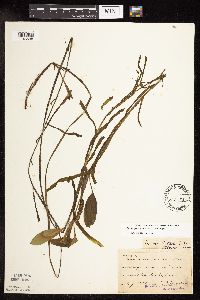 Potamogeton epihydrus Rafinesque 52198[1146538]Anderson, A. An6721893-08-00 United States, Minnesota, Cass, Gull Lake, Cass Co.;;N;;, 46.446379 -94.35099 |
MIN:Plants | 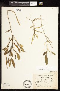 Potamogeton epihydrus Rafinesque 52396[1146649]Linderman, Ray s.n.1936-08-20 United States, Minnesota, Clearwater, Clearwater Co. Pool near hwy no. 71, Itasca Park;Itasca State Park;143N;36W;, 47.197458 -95.201964 |
MIN:Plants | 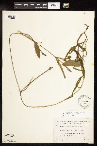 Potamogeton epihydrus Rafinesque 525684[1146593]Lakela, Olga 190101955-08-03 United States, Minnesota, Saint Louis, St. Louis Co.; Johnson's Lake at the sea plane base, S of Namakan Lake, R68W, T18N.;Voyageurs National Park;068N;18W;, 48.433517 -92.705646 |
MIN:Plants | 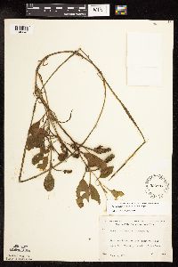 Potamogeton epihydrus Rafinesque 525907[1146643]Lakela, Olga 189081955-06-21 United States, Minnesota, Saint Louis, St. Louis Co. Vermilion River; Gold Mine Camp, S of Crane Lake;Kabetogama State Forest;N;;, 48.2833 -92.4667 |
MIN:Plants | 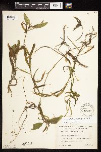 Potamogeton epihydrus Rafinesque 526890[1146547]Lakela, Olga 179001954-07-23 United States, Minnesota, Saint Louis, St. Louis Co.; Gun Lake. T65N, R12W, Sec. 14, about 4 mi S of Friday Bay on Crooked Lake.;Boundary Waters Canoe Area Wilderness / Superior National Forest;065N;12W;14, 48.203274 -91.857461 |
MIN:Plants | 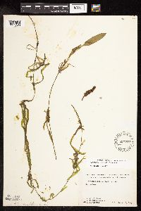 Potamogeton epihydrus Rafinesque 527949[1146529]Fallstad, R.; et al. s.n.1955-08-16 United States, Minnesota, Clearwater, Clearwater Co. Jeanne Lake;;;;, 47.187258 -95.184569 |
MIN:Plants | 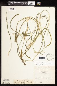 Potamogeton epihydrus Rafinesque 531869[1146545]Fassett, N. 290151953-07-30 United States, Minnesota, Clearwater, Clearwater Co.; at E end of Long Lake, NW of Lake Itasca;;N;;, 47.276488 -95.298664 |
MIN:Plants | 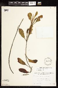 Potamogeton epihydrus Rafinesque 532375[1146577]Lakela, Olga 208151956-08-16 United States, Minnesota, Saint Louis, St. Louis Co.; Floodwood River near its mouth into Floodwood Lake.;;054N;21W;, 47.168272 -93.035201 |
MIN:Plants | 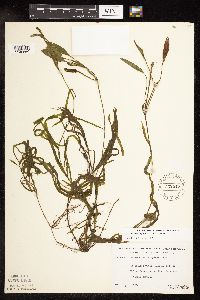 Potamogeton epihydrus Rafinesque 532515[1146660]Lakela, Olga; Elwell, M. 206741956-08-07 United States, Minnesota, Saint Louis, Narrows between Bullet Lakes, N of Ely;Boundary Waters Canoe Area Wilderness / Superior National Forest;065N;12W;12, 48.126307 -91.796631 |
MIN:Plants | 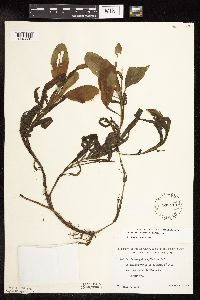 Potamogeton epihydrus Rafinesque 533113[1146591]Lakela, Olga 203351956-07-09 United States, Minnesota, Saint Louis, St. Louis Co.; Floodwood River, near the inlet to the lake, Hwy. 73.;;054N;21W;, 47.168272 -93.035201 |
MIN:Plants | 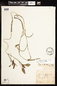 Potamogeton epihydrus Rafinesque 53355[1146537]Arthur, J.; et al. B4101886-07-25 United States, Minnesota, Saint Louis, Burntside L. Vermilion Lake;Superior National Forest;063N;12W;00, 47.891581 -92.366824 |
MIN:Plants | 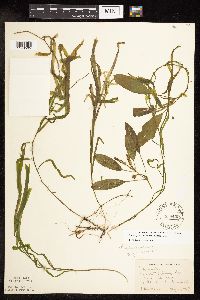 Potamogeton epihydrus Rafinesque 538409[1146565]Anderson, W. s.n.1947-08-13 United States, Minnesota, Hubbard, Pond E of Deming Lake. Itasca State Park. Hubbard Co.;Itasca State Park;143N;35W;, 47.19592 -95.107697 |
MIN:Plants | 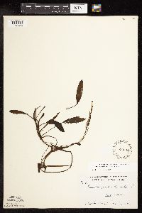 Potamogeton epihydrus Rafinesque 539594[1146525]U.S. Forest Service personnel 361937-07-12 United States, Minnesota, Cook, Devil's Track Lake;Superior National Forest;062N;01W;, 48.092486 -90.774657 |
MIN:Plants | 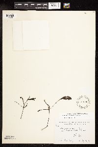 Potamogeton epihydrus Rafinesque 539595[1146551]U.S. Forest Service personnel s.n.1937-07-13 United States, Minnesota, Cook, Pike Lake;Superior National Forest;061N;02W;, 47.765692 -90.591554 |
MIN:Plants | 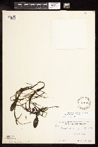 Potamogeton epihydrus Rafinesque 539604[1146659]Krefting, L. 61936-07-24 United States, Minnesota, Cook, Cook Co. Swamp Lake;;N;;, 47.726653 -90.386005 |
MIN:Plants | 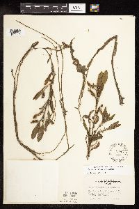 Potamogeton epihydrus Rafinesque 542915[1146636]Lakela, Olga 219821957-08-14 United States, Minnesota, Lake, Lake County...Greenwood Lake; hwy #2, N of Two Harbors, Lake Co.;Superior National Forest;058N;10W;18, 47.5 -91.6333 |
MIN:Plants | 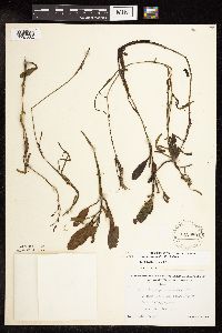 Potamogeton epihydrus Rafinesque 542980[1146562]Lakela, Olga 221801957-08-20 United States, Minnesota, Lake, Endless Waters Trail, in logging area;;;;, 47.878867 -91.113365 |
MIN:Plants | 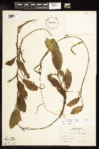 Potamogeton epihydrus Rafinesque 542982[1146638]Lakela, Olga 222401957-09-04 United States, Minnesota, Lake, Farm Lake 6 mi NE [actually straight E] of Ely;;N;;, 47.899367 -91.725322 |
MIN:Plants | 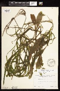 Potamogeton epihydrus Rafinesque 543067[1146586]Lakela, Olga 221281957-08-19 United States, Minnesota, Lake, Lake Co. South Kawishiwi River, Endless Waters Resort, S of Ely;Superior National Forest;N;;, 47.803947 -91.763654 |
MIN:Plants | 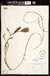 Potamogeton epihydrus Rafinesque 543477[1146564]Lakela, Olga 224941957-09-14 United States, Minnesota, Lake, Lake Co.; Snow Bank Lake, W side, the Lodge area;Boundary Waters Canoe Area Wilderness / Superior National Forest;N;;, 47.990254 -91.415684 |
MIN:Plants |  Potamogeton epihydrus Rafinesque 561090[1146561_1;1146561_2]Ownbey, Gerald 22181955-06-25 United States, Minnesota, Hubbard, Hubbard Co. About 2.5 mi SE of Itasca Park P.O.; Darling Pond.;;N;;, 47.260764 -95.069056 |
MIN:Plants |  Potamogeton epihydrus Rafinesque 561092[1146568]Ownbey, Gerald 22411955-07-04 United States, Minnesota, Hubbard, Hubbard Co. Itasca State Park. U.S. Hwy. 71, .3 mi S of its jct. with Minn. Hwy. 92; W side of road;Itasca State Park;143N;35W;, 47.19592 -95.107697 |
MIN:Plants |  Potamogeton epihydrus Rafinesque 566558[1149406]Grewe, A.; et al. s.n.1951-09-01 United States, Minnesota, Clearwater, Long Lake. About 4 mi NW of Lake Itasca village, along hwy 92;;144N;37W;, 47.276488 -95.298664 |
MIN:Plants |  Potamogeton epihydrus Rafinesque 57301[1146543]Butters, F. s.n.1919-08-00 United States, Minnesota, Saint Louis, N St. Louis Co.;;N;;, 48.026041 -92.445068 |
MIN:Plants | 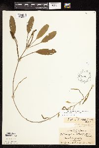 Potamogeton epihydrus Rafinesque 57993[1146633]MacMillan, C.; et al. 2031901-08-23 United States, Minnesota, Cook, Mud Lake, Cook Co.;Superior National Forest;061N;03W;, 48.1 -90.4167 |
MIN:Plants | 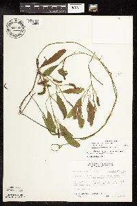 Potamogeton epihydrus Rafinesque 687733[1146554]Wheeler, Gerald; Glaser, Paul 21801977-07-21 United States, Minnesota, Itasca, Itasca Co. Coll. Site no. 132, SE1/4 NW1/4 Sec.1 T56N R26W, approx. 8.5 mi NNW of Grand Rapids; in bog lake, on far E s Itasca Co. Coll. Site no. 132, SE1/4 NW1/4 Sec.1 T56N R26W, approx. 8.5 mi NNW of Grand Rapids; in bog lake, on far E side. 056N 26W 1, 47.364471 -93.590051 |
MIN:Plants | 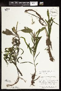 Potamogeton epihydrus Rafinesque 758992[1146558]Smith, Welby 74351982-08-20 United States, Minnesota, Mower, Cartney Wildlife Management Area. Mower Co. Cartney State Wildlife Management Area, ca. 5 mi. N-NW of LeRoy. West Branch Little Iowa River. NW1/4 NE1/4 Mower Co. Cartney State Wildlife Management Area, ca. 5 mi. N-NW of LeRoy. West Branch Little Iowa River. NW1/4 NE1/4 Sec. 5, T101N, R14W.. 101N 14W 5, 43.580049 -92.539234 |
MIN:Plants | 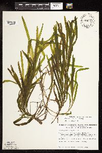 Potamogeton epihydrus Rafinesque 774211[1146655]Monson, Paul 5195a1982-07-28 United States, Minnesota, Saint Louis, Voyageurs National Park. St. Louis Co. R-21W, T-69N, SE1/4, S-2. Kabetogama Lake, Cutover Island;Voyageurs National Park;069N;21W;2, 48.470908 -93.008801 |
MIN:Plants | 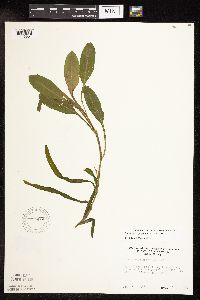 Potamogeton epihydrus Rafinesque 796479[1146557]Engels, A. s.n.1988-07-15 United States, Minnesota, Aitkin, Aitkin Co. Engels' (Sanford) Farm, hwy 69 ca. 2 mi SW of Palisade, in Mississippi River; T49N R25W Sec. 33 NW1/4;;049N;25W;33, 46.6921 -93.521461 |
MIN:Plants | 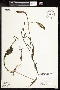 Potamogeton epihydrus Rafinesque 806891[1146615]Gessler, Walt s.n.1990-00-00 United States, Minnesota, Itasca, Itasca Co, Big Cow Horn Lake, T53N R25W Sec. 12 NE1/4 NW1/4;Golden Anniversary State Forest;053N;25W;12, 47.099308 -93.458058 |
MIN:Plants | 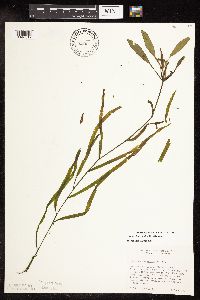 Potamogeton epihydrus Rafinesque 817647[1146617]Cholewa, A. 2011b1991-06-08 United States, Minnesota, Aitkin, Solana State Forest. Aitkin Co. Solano State Forest, Porupine Lake, ca 4 mi W of US hwy 65 on West White Pine Road; T45N, R24W, S13. 15 ft. f Aitkin Co. Solano State Forest, Porupine Lake, ca 4 mi W of US hwy 65 on West White Pine Road; T45N, R24W, S13. 15 ft. from shore.. 045N 24W 13, 46.383353 -93.316264 |
MIN:Plants | 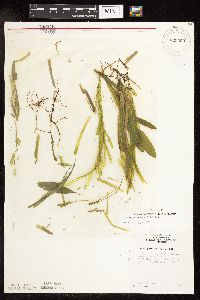 Potamogeton epihydrus Rafinesque 820303[1146635]Monson, Paul 44931961-06-28 United States, Minnesota, Clearwater, Clearwater Co. R-36 T-143 S-24. Itasca State Park. Pond on N side of Park Drive about 1 mi W of Mary Lake;Itasca State Park;143N;36W;24, 47.191898 -95.175349 |
MIN:Plants |  Potamogeton epihydrus Rafinesque 830999[1146555]Cholewa, A. 21071992-08-22 United States, Minnesota, Aitkin, Aitkin Co. Savanna State Forest, Camp Lakes, E lake, ca. 2 mi N of hwy.6 on co.rd.75. T49N R23W Sec.13 NW1/4.;Savanna State Forest;049N;23W;13, 46.734194 -93.207338 |
MIN:Plants |  Potamogeton epihydrus Rafinesque 831020[1146595]Cholewa, A. 21041992-08-22 United States, Minnesota, Aitkin, Aitkin Co. Savanna State Forest, Camp Lakes, W (main) lake, ca. 2 mi N of hwy.6 on co.rd.75. T49N R23W Sec.13 NW1/4.;Savanna State Forest;049N;23W;13, 46.734194 -93.207338 |
MIN:Plants |  Potamogeton epihydrus Rafinesque 831046[1146596]Cholewa, A. 20681992-07-00 United States, Minnesota, Aitkin, Aitkin Co. Hwy.169, ca. 1/2 mi S of Soo Line Trail. Abandoned peat mine. T50N R26W S15 NE1/4 SE1/4.;Hill River State Forest;050N;26W;15, 46.910193 -93.629979 |
MIN:Plants |  Potamogeton epihydrus Rafinesque 832343[1146588]Saari, H. s.n.1941-06-24 United States, Minnesota, Cook, Cook Co. Dyer's Lake;Finland State Forest / North Shore;058N;05W;, 47.726653 -90.386005 |
MIN:Plants |  Potamogeton epihydrus Rafinesque 833687[1146597]Monson, Paul 50371974-08-14 United States, Minnesota, Cook, Cook Co. R-1W, T-65N, S-2 Wampus Lake on Co. Rd. 66, 2 mi NE of Gunflint Trail. [this locale in T64];Superior National Forest;064N;01W;2, 48.076465 -90.493646 |
MIN:Plants |  Potamogeton epihydrus Rafinesque 833689[1146634]Monson, Paul 45871964-08-19 United States, Minnesota, Becker, Becker Co. R-36, T0142, NE1/4 S-10; pond about 1/4 mi W of Hwy 113, 2.8 mi W of jnc. with Hwy 71.;White Earth Indian Reservation / White Earth State Forest;142N;36W;10, 47.130926 -95.22254 |
MIN:Plants |  Potamogeton epihydrus Rafinesque 839225[1146514]Myhre, K. 44091993-08-08 United States, Minnesota, Pine, Pine Co. Located 6 mi NE of the town of Bruno; T44N R17W SW1/4 of SE1/4 of Sec 7.;;044N;17W;7, 46.309418 -92.541551 |
MIN:Plants |  Potamogeton epihydrus Rafinesque 455675[1146631]Gerdes, Lynden; Gerdes, D. Lawson 28031998-07-01 United States, Minnesota, Cook, Clearwater Lake, north side of lake. SENW of sec.;Boundary Waters Canoe Area Wilderness / Superior National Forest;065N;01E;27, 48.087449 -90.322587 |
MIN:Plants | 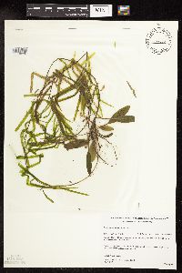 Potamogeton epihydrus Rafinesque 479792[1146630]Gerdes, Lynden; Gerdes, D. Lawson 31191998-08-10 United States, Minnesota, Cook, wetland just back of the bay at the far southeast end of Gunflint Lake. NESE of section;Superior National Forest;065N;02W;19, 48.09615 -90.694288 |
MIN:Plants | 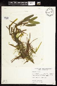 Potamogeton epihydrus Rafinesque 479794[1146629]Gerdes, Lynden; Gerdes, D. Lawson 31641998-08-14 United States, Minnesota, Cook, In pools of Arrow Creek along the "Long Portage", between Rose and Rat Lakes. (northwest portion); just north of portage. N1/2 of sec.;Boundary Waters Canoe Area Wilderness / Superior National Forest;065N;01W;24, 48.095999 -90.386208 |
MIN:Plants | 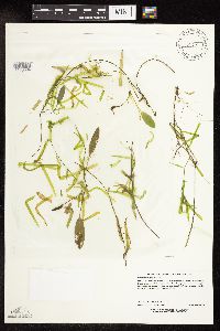 Potamogeton epihydrus Rafinesque 429681[1146594]Lee, Michael MDL24421998-09-10 United States, Minnesota, Mille Lacs, Mille Lacs Co.; Mille Lacs - Kathio State Park. 3-1/2 miles northwest of Onamia; T42N R27W SE1/4 of SE1/4 Sec. 14;Mille Lacs Kathio State Park;042N;27W;14, 46.119975 -93.71466 |
MIN:Plants | 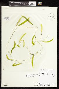 Potamogeton epihydrus Rafinesque 910427[1146607]Vacinek, Brent; Perleberg, D. 11242007-06-19 United States, Minnesota, Cass, Lake ID: 11014200. Long Lake. Near public access;Chippewa National Forest / Leech Lake Indian Reservation;141N;28W;13, 47.0154239 -94.1765669 |
MIN:Plants | 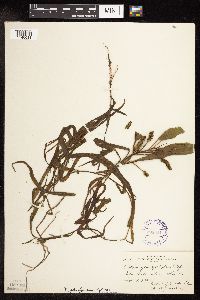 Potamogeton epihydrus Rafinesque 298021[1146611]Breckenridge, Walter 30981930-09-07 United States, Minnesota, Lake, Silver Island Lake [no known lake by this name] -- Lake Co.;;;;, 47.733268 -91.135248 |
MIN:Plants | 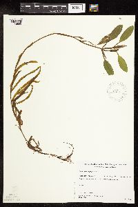 Potamogeton epihydrus Rafinesque 482451[1146520]Gerdes, Lynden; Gerdes, D. Lawson 27901998-07-01 United States, Minnesota, Cook, Clearwater Lake. NWNW of section;Boundary Waters Canoe Area Wilderness / Superior National Forest;065N;01E;26, 48.087449 -90.322587 |
MIN:Plants | 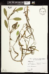 Potamogeton epihydrus Rafinesque 481002[1146618]Gerdes, Lynden 29261998-07-16 United States, Minnesota, Cook, T65N R03E S03SWNW. Cook County; Superior National Forest. West shore of Little John Lake.;Superior National Forest;065N;03E;3, 48.063612 -90.046985 |
MIN:Plants | 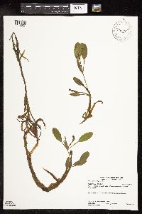 Potamogeton epihydrus Rafinesque 908394[1146627]Gerdes, Lynden; Smith, Welby R. 55982008-07-22 United States, Minnesota, Lake, Fourtown Lake. NENE of setion;Boundary Waters Canoe Area Wilderness / Superior National Forest;065N;11W;31, 48.0833 -91.7833 |
MIN:Plants |  Potamogeton epihydrus Rafinesque 491103[1146626]Gerdes, Lynden; VanderMeulen, David 36291999-07-25 United States, Minnesota, Cook, East Pike Lake. North shore towards the west end of the lake. SESE of setion;Boundary Waters Canoe Area Wilderness / Superior National Forest;065N;02E;26, 48.0667 -90.1 |
MIN:Plants | 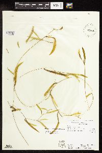 Potamogeton epihydrus Rafinesque 910426[1146608]Perleberg, D.; Vacinek, Brent 11232007-06-19 United States, Minnesota, Cass, Lake ID: 11014200, Long Lake. Near public access. [collector provided invalid lat/long];Chippewa National Forest / Leech Lake Indian Reservation;141N;28W;13, 47.0150639 -94.1765592 |
MIN:Plants | 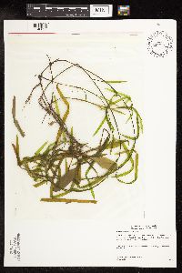 Potamogeton epihydrus Rafinesque 438834[1146625]Gerdes, Lynden; Carlson, Bruce 50292005-07-13 United States, Minnesota, Saint Louis, St. Louis River, south of Hoyt Lakes. Short distance NE of Norway Point landing. NW1/4 of NE1/4 of section;Superior National Forest;057N;14W;08, 47.589862 -92.461466 |
MIN:Plants | 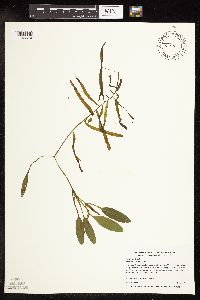 Potamogeton epihydrus Rafinesque 461116[1146610]Myhre, K. 68611997-07-08 United States, Minnesota, Carlton, Carlton Co.; Cole Lake. Located 2 miles southwest of the town of Wright. Plants occur along the northwest bays of lake; T 48N R 21W SE1/4 of NE1/4 of Sec 7. 048N 21W 7, 46.660929 -93.046471 |
MIN:Plants | 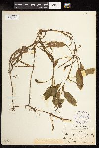 Potamogeton epihydrus Rafinesque 291991[1146609]Hotchkiss, N.; Jones, Percy 40821930-08-30 United States, Minnesota, Saint Louis, Long Lake;;;;, 47.95 -92.4667 |
MIN:Plants |  Potamogeton epihydrus Rafinesque 237867[1190882]Congdon, J. W. s.n.1894-08-15 United States, California, Tuolumne, Soda Springs.;Yosemite National Park |
MIN:Plants |  Potamogeton epihydrus Rafinesque 923138[1146603]Smith, Welby 160871989-08-11 United States, Minnesota, Cook, At the west end of Homer Lake, in the Boundary Waters Canoe Area...T 63N R 3W; SW1/4 NE1/4 sec 33;Boundary Waters Canoe Area Wilderness / Superior National Forest;063N;03W;33, 47.896805 -90.713034 |
MIN:Plants |  Potamogeton epihydrus Rafinesque 929668[1146606]Smith, Welby; Lee, Michael 313922009-08-26 United States, Minnesota, Cook, South side of Winchell Lake near the outlet of Tremble Lake. NE1/4 of NE1/4 of section;Boundary Waters Canoe Area Wilderness / Superior National Forest;064N;02W;32, 47.9883333 -90.6011111 |
MIN:Plants |  Potamogeton epihydrus Rafinesque 929667[1146605]Smith, Welby; Lee, Michael 314162009-08-28 United States, Minnesota, Cook, Between Wanihigan and Mulligan Lakes. NW1/4 of SE1/4 of section;Boundary Waters Canoe Area Wilderness / Superior National Forest;063N;03W;01, 47.9655556 -90.6427778 |
MIN:Plants |  Potamogeton epihydrus Rafinesque 449813[1158313]Garton, C.; Campbell, H. 12611950-08-15 Canada, Ontario, Thunder Bay, Red Pine Island, Saganaga Lake, Minnesota-Thunder Bay Boundary |
MIN:Plants | 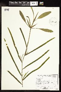 Potamogeton epihydrus Rafinesque 428530[1158314]Stratton, S.; Coulombe-Moore, M. 1121UM1996-06-28 United States, Wisconsin, Buffalo, Upper Mississippi River Corridor. Pool 4, River Mile 760.2. UTM E577336 N4915893. Along Nelson Dike road, on the upstream side, between the second and third boat landings after crossing the Wabash bridge;Upper Mississippi National Wildlife Refuge;;;, 44.65 -92.05 |
MIN:Plants | 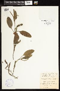 388287[1191077]Zenkert, C. A. s.n. United States, New York, Erie |
MIN:Plants | 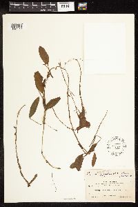 57191[1191078]Clark, J. A. 311 United States, Idaho, Ada |
MIN:Plants | 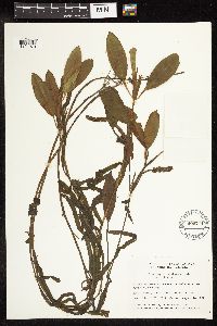 490771[1191079]Garton, C. E. 2144 Canada, Ontario, Thunder Bay |
MIN:Plants |  57292[1191080]Eglleston, W. W. s.n. United States, Vermont, Rutland |
MIN:Plants |  562428[1191081]Porter, C. L. 7950 United States, Wyoming, Carbon |
MIN:Plants |  598856[1191082]Tryon, R. M. 2653 United States, Indiana, LaPorte |
MIN:Plants |  562762[1191083]Radford, A. E. 28769 United States, North Carolina, Wayne |
MIN:Plants |  434042[1191084]Richards, C. D. 4036 United States, Michigan, Keweenaw |
MIN:Plants | 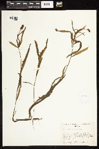 425560[1191085]Cronquist, A. 6037 United States, Idaho, Shoshone |
MIN:Plants | 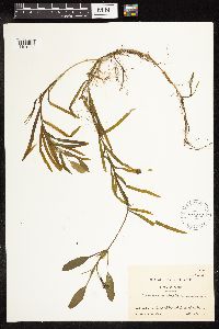 570866[1191086]Malte, M. O. 666/23 Canada, Quebec |
MIN:Plants | 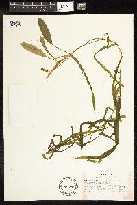 504052[1191087]Russell, N. H. 713549 United States, New York, Albany |
MIN:Plants | 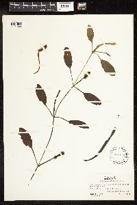 589712[1191088]Ogden, E. C. 1585 United States, New York, Jefferson |
MIN:Plants |  273074[1191089]Oosting, H. J. 262 United States, Michigan, Ottawa |
MIN:Plants |  291361[1191090]Muenscher, W. C. 1640 United States, New York, St. Lawrence |
MIN:Plants |  598855[1191091]Tryon, R. M. 2653 United States, Indiana, LaPorte |
MIN:Plants |  491928[1191092]Porter, C. L. 6315 United States, Colorado, Jackson |
MIN:Plants |  58422[1191093]Dodge, C. K. s.n. United States, Michigan, St. Clair |
MIN:Plants |  345727[1191094]Neal, O. M. 4544 United States, Maine, York |
MIN:Plants |  355294[1191095]Schuette, J. H. s.n. United States, Wisconsin, Brown |
MIN:Plants |  386423[1191096]Gilbert, F. A. 787 United States, West Virginia, Braxton |
MIN:Plants |  386515[1191097]Senn, H. A. 1866 Canada, Quebec, Gatineau |
MIN:Plants | 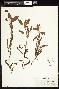 57382[1191098]anonymous s.n. United States |
MIN:Plants | 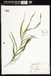 656352[1191099]Abair, C. s.n. United States, Washington, Thurston |
MIN:Plants | 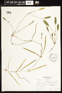 670841[1191100]Aiken, S. 505 Canada, Quebec, Pontiac |
MIN:Plants | 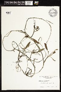 680118[1191101]Ahles, H. E. 77782 United States, Massachusetts, Franklin |
MIN:Plants |  686789[1191102]Wenstrom, B. s.n. United States, Wisconsin, Bayfield |
MIN:Plants |  738124[1191103]Monson, P. H. 4080 United States, Wisconsin, Douglas |
MIN:Plants |  933433[1191104]Halse, R. R. 8354 United States, Oregon, Linn |
MIN:Plants |  923936[1191105]Rose, R. K. 444 United States, Wisconsin, Florence |
MIN:Plants | 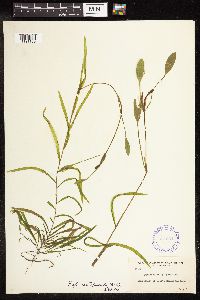 357551[1191106]Muenscher, W. C. 1156 United States, Washington, Whatcom |
MIN:Plants |  303478[1191109]Trudell, H. W. s.n. United States, New Jersey, [Camden] |
MIN:Plants | 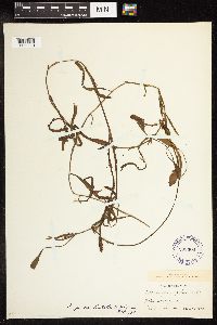 293300[1191110]Dobbin, F. 1110 United States, New York |
MIN:Plants |  486250[1191111]Moses, A. 6666 Canada, New Brunswick, Charlotte |
MIN:Plants |  486251[1191112]Forbes, F. F. s.n. United States, Massachusetts, Plymouth |
MIN:Plants |  273075[1191113]Oosting, H. J. 263 United States, Michigan, Ottawa |
MIN:Plants | 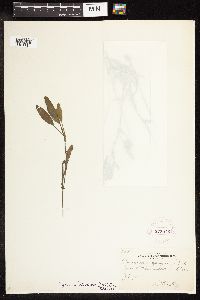 273076[1191114]Oosting, H. J. 264 United States, Michigan, Kalamazoo |
MIN:Plants | 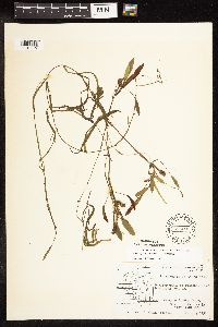 593201[1191115]Hartley, T. G. 4855 United States, Wisconsin, Jackson |
MIN:Plants | 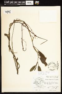 593266[1191116]Hartley, T. G. 8267 United States, Wisconsin, Juneau |
MIN:Plants | 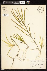 448006[1191117]Abbott, R. S. s.n. United States, New York, Nassau |
MIN:Plants | 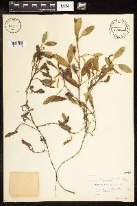 448007[1191118]Abbott, R. S. s.n. United States, Pennsylvania, Pike |
MIN:Plants | 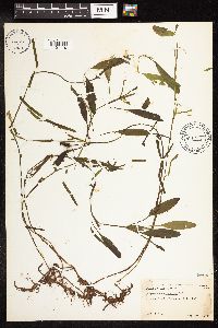 448038[1191119]Abbott, R. S. s.n. United States, New York, Nassau |
Google Map
Google Maps is a web mapping service provided by Google that features a map that users can pan (by dragging the mouse) and zoom (by using the mouse wheel). Collection points are displayed as colored markers that when clicked on, displays the full information for that collection. When multiple species are queried (separated by semi-colons), different colored markers denote each individual species.