University of Minnesota
http://www.umn.edu/
612-625-5000
http://www.umn.edu/
612-625-5000
Minnesota Biodiversity Atlas
Bell Museum
Dataset: MIN-Plants
Taxa: Rosaceae
Search Criteria: excluding cultivated/captive occurrences
Bell Museum plants | |
 MIN:Plants | 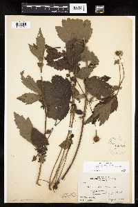 Geum aleppicum Jacquin 128014[1027284]Rosendahl, C.; Butters, F. 33651916-08-08 United States, Minnesota, Stearns, 15 mi. S of St. Cloud. Stearns Co.;;N;;, 45.332802 -94.15 |
MIN:Plants | 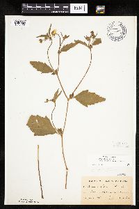 Geum aleppicum Jacquin 128015[1027312]Kassube, J. s.n.1878-06-00 United States, Minnesota, Hennepin, Minneapolis;;N;;, 44.979965 -93.263836 |
MIN:Plants | 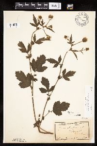 Geum aleppicum Jacquin 128016[1027337]Campbell, Jennie s.n.1897-07-00 United States, Minnesota, Otter Tail, Clitherall;;;;, 46.250427 -95.666589 |
MIN:Plants | 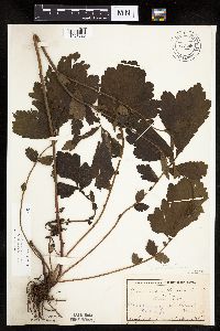 Geum aleppicum Jacquin 128018[1027225]Campbell, Jennie s.n.1895-07-00 United States, Minnesota, Stearns, Waite Park, St. Cloud;;124N;28W;, 45.557693 -94.1603 |
MIN:Plants |  Geum aleppicum Jacquin 128019[1027304]Skinner, S. 1691902-06-20 United States, Minnesota, Jackson, South String Lake, Heron Lake region;;N;;, 43.794959 -95.320276 |
MIN:Plants |  Geum aleppicum Jacquin 128020[1027226]Ballard, C. 25571900-08-00 United States, Minnesota, Kittson, St. Vincent;;163N;51W;, 48.9667 -97.2167 |
MIN:Plants |  Geum aleppicum Jacquin 128021[1027279]Ballard, C. B3691891-06-00 United States, Minnesota, Scott, Helena, Scott Co.;;113N;23W;, 44.608766 -93.55434 |
MIN:Plants |  Geum aleppicum Jacquin 128022[1027343]Taylor, B. T8451891-07-00 United States, Minnesota, Pope, Glenwood;;N;;, 45.648982 -95.401248 |
MIN:Plants |  Geum aleppicum Jacquin 128023[1284199]Aiton, George B. s.n.1891-08-00 United States, Minnesota, Douglas, [no further data], 46.044191 -95.289887 |
MIN:Plants |  Geum aleppicum Jacquin 128025[1027281]Sheldon, Edmund S6911891-07-00 United States, Minnesota, Waseca, Waseca;;N;;, 44.077741 -93.507443 |
MIN:Plants |  Geum aleppicum Jacquin 128026[1284211]Aiton, George B. s.n.1889-07-00 United States, Minnesota, Hennepin, [no further data], 45 -93.47 |
MIN:Plants |  Geum aleppicum Jacquin 128027[1027393]Lyon, H. 1951899-07-07 United States, Minnesota, Houston, Crooked Creek;Dorer Memorial Hardwood State Forest;N;;, 43.592621 -91.284352 |
MIN:Plants |  Geum aleppicum Jacquin 228288[1027319]Stork, H. 10721925-00-00 United States, Minnesota, Itasca, Bowstring;Chippewa National Forest;;;, 47.54306 -93.79639 |
MIN:Plants |  Geum aleppicum Jacquin 263973[1284212]Holzinger, J. s.n.1901-08-00 United States, Minnesota, Winona, [no further data], 44.0333 -91.6333 |
MIN:Plants |  Geum aleppicum Jacquin 265848[1284210]Flygare, L. E. s.n.1923-07-01 United States, Minnesota, Sherburne, Sherburne County[no further data], 45.443953 -93.774595 |
MIN:Plants |  Geum aleppicum Jacquin 270051[1027276]Wheeler, William 761893-07-12 United States, Minnesota, Houston, Winnebago Valley;Dorer Memorial Hardwood State Forest;N;;, 43.537379 -91.40119 |
MIN:Plants |  Geum aleppicum Jacquin 276084[1027240]Grant, Martin 27311929-07-10 United States, Minnesota, Clearwater, Itasca Park. Lodge road. NW1/4 NW1/4 Sec. 12, T143N, R36W.;Itasca State Park;143N;36W;12, 47.217691 -95.180249 |
MIN:Plants | 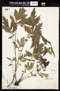 Geum aleppicum Jacquin 277193[1027331]Rosendahl, C. 58911929-07-08 United States, Minnesota, Clearwater, road to Bear Point, Itasca Park;Itasca State Park;143N;36W;, 47.195125 -95.225997 |
MIN:Plants | 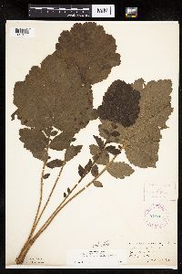 Geum aleppicum Jacquin 278104[1027375]Roberts, Thomas s.n.1889-08-02 United States, Minnesota, Hennepin, Minneapolis;;N;;, 44.979965 -93.263836 |
MIN:Plants | 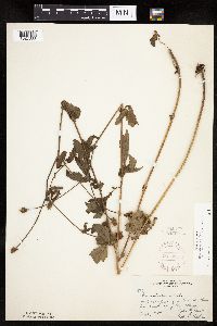 Geum aleppicum Jacquin 297838[1027333]Moyle, J.; et al. 18981934-08-21 United States, Minnesota, Saint Louis, 1/2 mi S of Bass lake, 8 mi NW of Ely;Superior National Forest;;;, 48.01268 -91.820829 |
MIN:Plants | 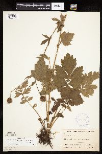 Geum aleppicum Jacquin 348377[1027320]Buell, Murray; Buell, Helen 6361933-07-31 United States, Minnesota, Anoka, Decodon pond;Cedar Creek National History Area;034N;23W;27, 45.407304 -93.193857 |
MIN:Plants | 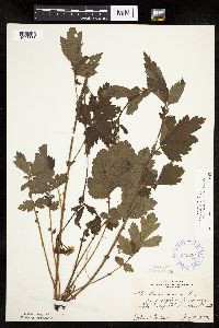 Geum aleppicum Jacquin 349284[1027338]Nielsen, E. 20941933-07-05 United States, Minnesota, Becker, near Lake Sally, Detroit Lakes;;138N;41W;, 46.817181 -95.845325 |
MIN:Plants | 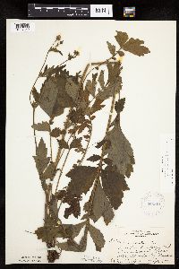 Geum aleppicum Jacquin 349801[1027350]Nielsen, E. 21121933-07-05 United States, Minnesota, Becker, Near fish hatchery, Lake Sally, Detroit Lakes.;;138N;41W;, 46.817181 -95.845325 |
MIN:Plants | 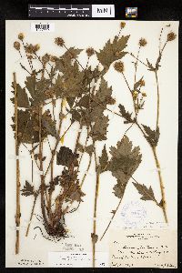 Geum aleppicum Jacquin 351564[1027339]Benner, F.; Benner, J. 5131929-07-27 United States, Minnesota, Cook, near McLean's cottage at Grand Portage;Grand Portage Indian Reservation / North Shore;063N;06E;, 47.9667 -89.7667 |
MIN:Plants | 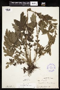 Geum aleppicum Jacquin 352364[1027277]Nielsen, E. 27051934-06-30 United States, Minnesota, Becker, Lake Munson, Detroit Lakes.;;138N;41W;, 46.817181 -95.845325 |
MIN:Plants |  Geum aleppicum Jacquin 352372[1027305]Nielsen, E. 27301934-07-03 United States, Minnesota, Becker, W arm, S end of Long Lake, Detroit Lakes;;N;;, 46.816986 -95.889435 |
MIN:Plants |  Geum aleppicum Jacquin 353881[1027351]Lakela, Olga 28311938-10-02 United States, Minnesota, Saint Louis, Bayside, Sec. 20, Duluth.;;N;;, 46.7833 -92.1 |
MIN:Plants |  Geum aleppicum Jacquin 356580[1027374]Rosendahl, C.; Dahlberg, R. s.n.1918-08-00 United States, Minnesota, Saint Louis, Duluth;;N;;, 46.7833 -92.1 |
MIN:Plants |  Geum aleppicum Jacquin 358692[1027329]Rosendahl, C. 5031902-06-14 United States, Minnesota, Houston, Spring Grove;;101N;07W;, 43.543165 -91.672028 |
MIN:Plants | 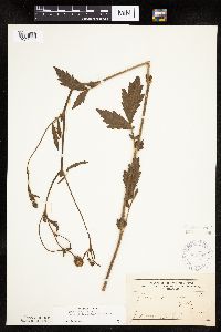 Geum aleppicum Jacquin 364088[1027335]Frost, W. s.n.1892-07-00 United States, Minnesota, Kandiyohi, Willmar;;119N;35W;, 45.12194 -95.04306 |
MIN:Plants | 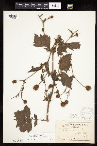 Geum aleppicum Jacquin 364090[1027336]Taylor, B. s.n.1892-08-00 United States, Minnesota, Chisago, Center City;;;;, 45.389814 -92.821151 |
MIN:Plants | 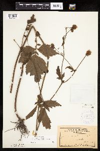 Geum aleppicum Jacquin 364132[1027334]Sheldon, Edmund s.n.1892-07-00 United States, Minnesota, Mille Lacs, Milaca;;;;, 45.755799 -93.654408 |
MIN:Plants | 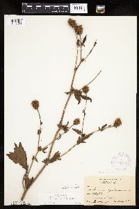 Geum aleppicum Jacquin 364738[1027380]Holzinger, John s.n.1901-08-00 United States, Minnesota, Winona, Winona Co.;;N;;, 43.98685 -91.779129 |
MIN:Plants | 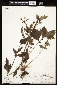 Geum aleppicum Jacquin 369296[1027232]Lakela, Olga 44161941-06-28 United States, Minnesota, Saint Louis, Bordering Forest Hill Cemetery, Duluth;;N;;, 46.7833 -92.1 |
MIN:Plants | 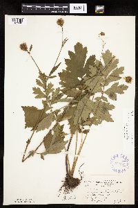 Geum aleppicum Jacquin 372537[1027248]Moore, John; et al. 147481941-07-06 United States, Minnesota, Otter Tail, Otter Tail County...W-facing slope of Inspiration Peak;Inspiration Peak Scenic Wayside Park;131N;39W;22, 46.136072 -95.573654 |
MIN:Plants | 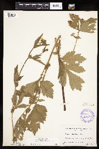 Geum aleppicum Jacquin 387217[1027332]Linnaean Club, U of M, 2521942-06-26 United States, Minnesota, Rice, Nerstrand Woods, Rice Co, along road, across from sheep farm;Nerstrand Woods State Park;110N;19W;, 44.341172 -93.111247 |
MIN:Plants | 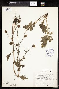 Geum aleppicum Jacquin 393204[1027266]Ownbey, Gerald; et al. 11421948-08-18 United States, Minnesota, Cook, Cook County...Around cabin, northern promentory of Susie Island, Susie Islands near Grand Portage;North Shore / Susie Islands, The Nature Conservancy;063N;07E;, 47.95 -89.6833 |
MIN:Plants |  Geum aleppicum Jacquin 400962[1027298]Brown, Spencer s.n.1935-00-00 United States, Minnesota, Cook, Grand Portage, T63N, R6E;Grand Portage Indian Reservation / North Shore;063N;06E;, 47.962387 -89.683423 |
MIN:Plants |  Geum aleppicum Jacquin 400963[1027296]Burns, G.; Hendrickson, M. 2951938-07-27 United States, Minnesota, Cook, S end of South Fowl Lake, T64N, R3E;Superior National Forest;064N;03E;, 48.075089 -90.022876 |
MIN:Plants |  Geum aleppicum Jacquin 400964[1027297]Burns, G.; Hendrickson, M. 2601938-07-25 United States, Minnesota, Cook, Cook Co.; portage trail on Lower Royal River, T64N, R3E;Superior National Forest;064N;03E;, 48.057803 -90.019427 |
MIN:Plants |  Geum aleppicum Jacquin 405808[1027322]Rosendahl, C. 78941948-08-14 United States, Minnesota, Cook, E of Grand Portage village;Grand Portage Indian Reservation / North Shore;063N;06E;, 47.9667 -89.7667 |
MIN:Plants |  Geum aleppicum Jacquin 407222[1027318]Lakela, Olga 85531949-06-26 United States, Minnesota, Saint Louis, Terrace of White Iron Lake, E of Ely;Superior National Forest;062N;18W;, 47.872629 -91.793624 |
MIN:Plants |  Geum aleppicum Jacquin 407825[1027215]Lakela, Olga 93501949-08-13 United States, Minnesota, Saint Louis, Prairie lake, SW St. Louis Co.;;050N;20W;, 46.79124 -92.904888 |
MIN:Plants |  Geum aleppicum Jacquin 412295[1027269]Moore, John; Moore, Marjorie 120801939-08-23 United States, Minnesota, Koochiching, Koochiching Co.; On the E bank of the Black River at Loman On the E bank of the Black River at Loman. 158N 25W , 48.501412 -93.794927 |
MIN:Plants |  Geum aleppicum Jacquin 412898[1027265]Moore, John; Moore, Marjorie 118961939-08-18 United States, Minnesota, Koochiching, Koochiching Co.; 1 mi E of Tilson Bay, Rainy Lake 1 mi E of Tilson Bay, Rainy Lake. 071N 22W , 48.607149 -93.198812 |
MIN:Plants | 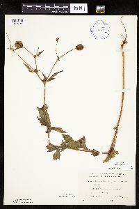 Geum aleppicum Jacquin 416709[1027365]Lakela, Olga 90621949-07-20 United States, Minnesota, Saint Louis, Prairie Lake terrace, SW part of the county.;;050N;20W;, 46.79124 -92.904888 |
MIN:Plants | 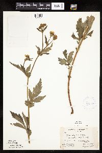 Geum aleppicum Jacquin 419230[1027261]Briggs, John De Q.; Briggs, Marjorie 821945-08-03 United States, Minnesota, Cook, Near Sawbill Lodge; T62N R4W;Boundary Waters Canoe Area Wilderness / Superior National Forest;062N;04W;, 47.88583 -90.87778 |
MIN:Plants | 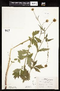 Geum aleppicum Jacquin 419359[1027366]Lakela, Olga 122311950-08-08 United States, Minnesota, Saint Louis, Savanna River bank at Floodwood.;;051N;29W;, 46.92911 -92.919648 |
MIN:Plants | 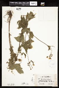 Geum aleppicum Jacquin 419689[1027367]Lakela, Olga 109821950-07-30 United States, Minnesota, Saint Louis, Floodwood Peat Processing Plant.;;N;;, 46.92911 -92.919648 |
MIN:Plants |  Geum aleppicum Jacquin 420570[1027262]Lakela, Olga 106971950-07-16 United States, Minnesota, Saint Louis, The new University [of Minnesota] Campus, Duluth;;050N;14W;14, 46.7833 -92.1 |
MIN:Plants |  Geum aleppicum Jacquin 420822[1027345]Lakela, Olga 108491950-07-26 United States, Minnesota, Saint Louis, Hwy. terrace at Stony Point, Lake Superior.;North Shore;051N;12W;02, 46.9167 -91.8167 |
MIN:Plants |  Geum aleppicum Jacquin 421237[1027373]Lakela, Olga 113951950-08-14 United States, Minnesota, Saint Louis, St. Louis River woods at Fond du Lac, Duluth.;;048N;15W;, 46.7833 -92.1 |
MIN:Plants |  Geum aleppicum Jacquin 422725[1027220]Lakela, Olga 75511948-06-20 United States, Minnesota, Saint Louis, On DMIR tracks on Kelsey-Payne Road;;N;;, 47.562304 -92.379883 |
MIN:Plants | 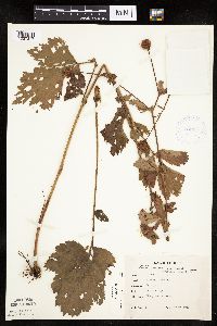 Geum aleppicum Jacquin 424017[1027317]Emanuel, J. 1371946-09-03 United States, Minnesota, Itasca, County: Itasca. Locality: Nashwauk Township;;057N;22W;00, 47.40917 -93.195 |
MIN:Plants | 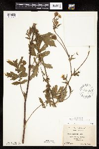 Geum aleppicum Jacquin 427720[1027372]Jones, George Neville 180111946-07-05 United States, Minnesota, Saint Louis, Armstrong Lake, near Ely.;;062N;14W;, 47.850158 -92.075839 |
MIN:Plants | 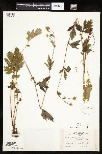 Geum aleppicum Jacquin 442578[1027272]Lakela, Olga 129911951-07-10 United States, Minnesota, Saint Louis, Namakan Lake, along trails Kettle Falls;Voyageurs National Park;070N;18W;, 48.49944 -92.63889 |
MIN:Plants | 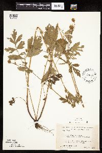 Geum aleppicum Jacquin 445804[1027263]Moore, John; Huff, N. 179371945-07-24 United States, Minnesota, Morrison, 1 mi S of Cushing;;N;;, 46.12521 -94.576956 |
MIN:Plants | 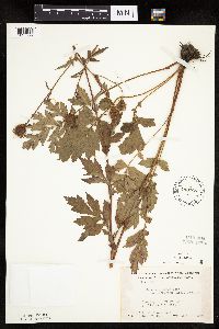 Geum aleppicum Jacquin 448768[1027292]Moore, John; Hall, Robert 166951944-08-01 United States, Minnesota, Aitkin, 1/2 mi E of Aitkin;;047N;27W;, 46.533131 -93.699212 |
MIN:Plants | 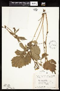 Geum aleppicum Jacquin 448839[1027264]Moore, John; et al. 177461945-07-11 United States, Minnesota, Goodhue, 3/4 mi SW of Kenyon;;;;, 44.264505 -92.996211 |
MIN:Plants | 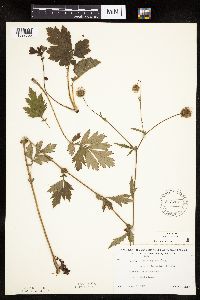 Geum aleppicum Jacquin 543227[1027363]Lakela, Olga 217601957-08-03 United States, Minnesota, Lake, Shore of Lake Superior, NE of Knife River.;;N;;, 46.946524 -91.794017 |
MIN:Plants | 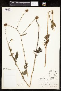 Geum aleppicum Jacquin 550801[1027300]Cotter Tucker, Shirley 38671956-08-09 United States, Minnesota, Roseau, near Badger;;N;;, 48.782478 -96.014448 |
MIN:Plants | 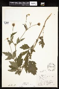 Geum aleppicum Jacquin 550802[1027330]Cotter, Shirley 7021948-07-27 United States, Minnesota, Clearwater, roadside to gravel pit, across from biol. station, Itasca Park;Itasca State Park;143N;36W;, 47.195125 -95.225997 |
MIN:Plants | 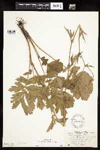 Geum aleppicum Jacquin 558120[1027349]Stevens, O. 21161959-07-14 United States, Minnesota, Clay, Moorhead.;;139N;48W;, 46.873852 -96.767581 |
MIN:Plants | 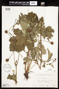 Geum aleppicum Jacquin 572904[1027268]Moore, John 256101961-07-18 United States, Minnesota, Isanti, 1/2 mi E of the NW corner of Cedar Creek Natural History Area;Cedar Creek National History Area;034N;23W;, 45.432885 -93.177951 |
MIN:Plants | 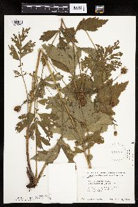 Geum aleppicum Jacquin 574785[1027362]Moore, John 247521959-07-30 United States, Minnesota, Kittson, Along creek in the woods, 3 1/2 mi. NW of Lake Bronson.;;N;;, 48.771337 -96.717126 |
MIN:Plants | 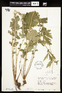 Geum aleppicum Jacquin 582427[1027246]Isaak, Daniel s.n.1958-00-00 United States, Minnesota, Clearwater, Itasca State Park, across the hwy. from the biological station.;Itasca State Park;143N;36W;, 47.197458 -95.201964 |
MIN:Plants | 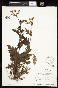 Geum aleppicum Jacquin 583296[1027299]Kellner, H. 941956-06-26 United States, Minnesota, Lake, Lake Co, Station 4, Lafayette Bluff [this is near mouth of Encampment River];North Shore;053N;10W;11, 47.170568 -91.647922 |
MIN:Plants | 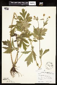 Geum aleppicum Jacquin 594114[1027286]Thorne, Robert 309271962-07-09 United States, Minnesota, Clearwater, N end Bear Paw Point, Itasca State Park; NE1/4 Sec. 11 T143N R36W;Itasca State Park;143N;36W;11, 47.218013 -95.200853 |
MIN:Plants | 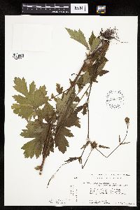 Geum aleppicum Jacquin 616670[1027360]Moore, John; Moore, Marjorie 2681969-07-11 United States, Minnesota, Crow Wing, Crow Wing Natural Area. Crow Wing Natural History Area, On the border of marsh, S end of Chandler Lake, S end of Chandler Lake, SW1/4, Sec. 22, Crow Wing Natural History Area, On the border of marsh, S end of Chandler Lake, S end of Chandler Lake, SW1/4, Sec. 22, Garrison Twp.. 044N 28W 22, 46.278961 -93.86289 |
MIN:Plants | 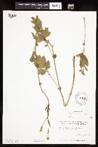 Geum aleppicum Jacquin 619129[1027347]Westkaemper, Remberta s.n.1970-06-00 United States, Minnesota, Stearns, Stearns Co. St. Joseph;;124N;29W;, 45.564772 -94.317966 |
MIN:Plants | 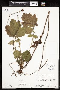 Geum aleppicum Jacquin 619812[1027359]Ownbey, Gerald 43901970-09-07 United States, Minnesota, Washington, Afton Hills, 1 mi. W of Afton. T28N, R20W, SW1/4 Sec. 15.;;028N;20W;15, 44.909023 -92.796752 |
MIN:Plants | 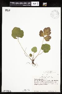 Geum aleppicum Jacquin 670720[1027346]Heitlinger, M. 4481971-10-10 United States, Minnesota, McLeod, Schaefer Prairie. SE1/4 of Sec. 34, T115N, R29W. NE corner of prairie.;Schaefer Prairie, The Nature Conservancy;115N;29W;34, 44.724106 -94.305158 |
MIN:Plants | 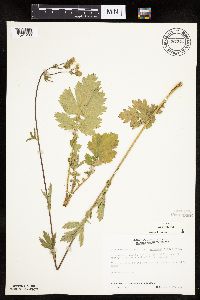 Geum aleppicum Jacquin 687273[1027293]Wheeler, Gerald; Glaser, Paul 17031977-06-20 United States, Minnesota, Itasca, Coll. site no. 39; SE1/4 SE1/4 S29, T57N, R25W; ca 10 mi N of Grand Rapids;;057N;25W;29, 47.381921 -93.530214 |
MIN:Plants |  Geum aleppicum Jacquin 687289[1027357]Wheeler, Gerald; Glaser, Paul 17181977-06-27 United States, Minnesota, Itasca, Leech Lake Indian Reservation. Itasca Co.; Site 60. NE1/4 SE1/4 Sec. 26, T145N, R25W; Deer River. In a roadside drainage ditch just adjacent to the D Itasca Co.; Site 60. NE1/4 SE1/4 Sec. 26, T145N, R25W; Deer River. In a roadside drainage ditch just adjacent to the Deer River Forestry Station.. 145N 25W 26, 47.344628 -93.797285 |
MIN:Plants |  Geum aleppicum Jacquin 687303[1027358]Wheeler, Gerald; Glaser, Paul 17321977-06-27 United States, Minnesota, Itasca, Site 63. NW1/4 NW1/4 Sec. 15, T56N, R27W; ca. 11.5 mi. NW of Grand Rapids. In a roadside drainage ditch adjacent to Hw Site 63. NW1/4 NW1/4 Sec. 15, T56N, R27W; ca. 11.5 mi. NW of Grand Rapids. In a roadside drainage ditch adjacent to Hwy. 169.. 056N 27W 15, 47.375883 -93.826519 |
MIN:Plants |  Geum aleppicum Jacquin 696735[1027353]Smith, Welby 6241978-07-04 United States, Minnesota, Wright, Wright Co.; T121N, R26W, NW1/4 Sec. 10. About 1/4 mi. N of state aid road 39.;Lake Maria State Park;121N;26W;10, 45.303961 -93.942893 |
MIN:Plants |  Geum aleppicum Jacquin 698668[1284205]Wheeler, Gerald 33991978-10-22 United States, Minnesota, Koochiching, Red Lake Peatland Scientific Natural Area. SW1/4 SE1/4 Sec. 3, T156N, R29W. On a beach ridge 16 mi. NNE of Waskish. SW1/4 SE1/4 Sec. 3, T156N, R29W. On a beach ridge 16 mi. NNE of Waskish., 48.360681 -94.349301 |
MIN:Plants | 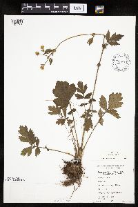 Geum aleppicum Jacquin 698814[1027361]Sather, Nancy; et al. 1991976-06-23 United States, Minnesota, Saint Louis, Skibo Mill. NW1/4 SW1/4 NW1/4 Sec. 36, T58N, R13W.;;058N;13W;36, 47.46683 -91.929834 |
MIN:Plants | 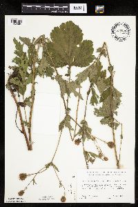 Geum aleppicum Jacquin 700725[1027364]Ownbey, Gerald 60441978-07-09 United States, Minnesota, Clearwater, T145N, R36W, SE1/4 Sec. 27. 6.6. mi. due N of Lake Itasca P.O, W side of roadway.;;145N;36W;27, 47.344295 -95.23162 |
MIN:Plants | 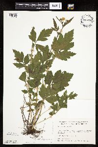 Geum aleppicum Jacquin 700870[1027212]Dorio, J. 2721977-06-20 United States, Minnesota, Morrison, Lake Alexander, ca. 7 mi. N of Randall on Co. Rd. 6. T131N, R30W, Sec. 6.;;131N;30W;6, 46.187068 -94.506234 |
MIN:Plants | 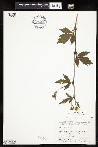 Geum aleppicum Jacquin 701055[1027288]Dorio, J. 3061977-06-21 United States, Minnesota, Morrison, Ripley Esker, ca. 3 mi. NE of Camp Ripley Jct. SW end of field. T42N, R31W, Sec. 19.;Ripley Esker Scientific Natural Area;042N;31W;19, 46.116667 -94.308333 |
MIN:Plants |  Geum aleppicum Jacquin 701180[1027352]Dorio, J. 2191977-06-14 United States, Minnesota, Stearns, Stearns Co. Partch woods, 4.5 mi. NW of St. Joseph on Co. Rd. 3. T125N, R29W, Sec. 19.;Partch Woods Scientific Natural Area;125N;29W;19, 45.622898 -94.377135 |
MIN:Plants |  Geum aleppicum Jacquin 701316[1027287]Dorio, J. 3311977-06-23 United States, Minnesota, Benton, Benton Co. Englund Ecotone, ca. 5 mi. SE of Rice. T37N, R31W, Sec. 13.;Englund Ecotone, The Nature Conservancy;037N;31W;13, 45.694726 -94.149118 |
MIN:Plants |  Geum aleppicum Jacquin 715654[1027270]Farrell, P. 751979-07-12 United States, Minnesota, Beltrami, Pennington Orchid Bog SNA, 1 mi N of Pennington; NW1/4 Sec. 3 T146N R30W;Leech Lake Indian Reservation / Pennington Bog Scientific Natural Area;146N;30W;3, 47.494806 -94.474276 |
MIN:Plants |  Geum aleppicum Jacquin 717373[1027241]Mathisen, Ron 1181979-07-11 United States, Minnesota, Hubbard, Spearhead Lake Reserve.;Spearhead Lake Preserve (Audubon);145N;34W;, 47.368324 -94.990759 |
MIN:Plants |  Geum aleppicum Jacquin 722645[1027237]Lustig, K. 6151979-07-03 United States, Minnesota, Anoka, 18 mi. SE of Cambridge;Boot Lake Scientific Natural Area;033N;22W;, 45.336687 -93.123956 |
MIN:Plants |  Geum aleppicum Jacquin 726453[1027382]Smith, Welby 27231980-07-09 United States, Minnesota, Saint Louis, T51N, R19W, NE1/4 NE1/4 NW1/4 Sec. 9. On the S side of Co. Rd. 8, ca. 7 1/2 mi. due E of Floodwood.;;051N;19W;9, 46.918403 -92.75393 |
MIN:Plants |  Geum aleppicum Jacquin 727602[1027378]Farrell, P. 1061979-07-10 United States, Minnesota, Polk, Pembina Trail Preserve Scientific Natural Area. Pembina Trail Preserve: (TNC) 6 1/2 mi. E of Harold, all sec. 36, frac. sec. 25, 30, 31, T149N, R45W, frac. sec. 1, 2, Pembina Trail Preserve: (TNC) 6 1/2 mi. E of Harold, all sec. 36, frac. sec. 25, 30, 31, T149N, R45W, frac. sec. 1, 2, T148N, R45W.. N , 47.666007 -96.334334 |
MIN:Plants |  Geum aleppicum Jacquin 727871[1027323]Lustig, K. 7151979-07-12 United States, Minnesota, Sherburne, Mississippi River Islands Scientific Natural Area. Sherburne & Wright Cos. ...Mississippi Scenic and Recreational River Islands SNA, Mississippi River Islands between Monticello and Elk River. Sec. 2, 3, 4, T32N, R26, 27W; sec. 7, 9, 18, T121N, R23, 24W. 032N 26W 3, 45.29348 -93.55625 |
MIN:Plants | 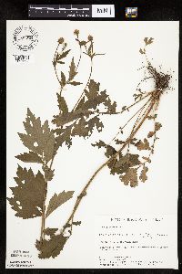 Geum aleppicum Jacquin 730318[1027324]Converse, C. 4201980-06-30 United States, Minnesota, Chisago, Goose Creek Natural Area, 5 mi SE of Rush City; NE1/4 NW1/4 Sec. 18 T36N R20W;Wild River State Park;036N;20W;18, 45.612945 -92.891839 |
MIN:Plants | 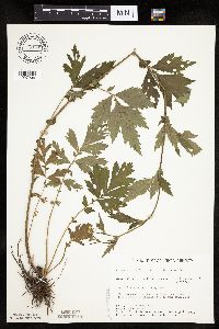 Geum aleppicum Jacquin 734349[1027206]Severson, M. 3821980-06-25 United States, Minnesota, Becker, Green Water Lake Natural Area, 5 mi W of Ponsford; NE1/4 SE1/4 Sec. 33 T141N R38W;Greenwater Lake Scientific Natural Area / White Earth Indian Reservation;141N;38W;33, 46.98243 -95.488945 |
MIN:Plants | 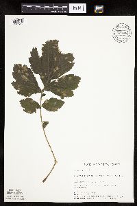 Geum aleppicum Jacquin 734682[1027325]Petron, T. 4271980-09-09 United States, Minnesota, Clay, Bluestem Prairie, 13 mi E of Moorhead; NE1/4 NE1/4 Sec. 15 T139N R46W;Bluestem Prairie Scientific Natural Area;139N;46W;15, 46.855337 -96.473419 |
MIN:Plants | 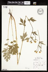 Geum aleppicum Jacquin 738167[1027387]Farrell, B. 471981-07-06 United States, Minnesota, Saint Louis, R14W, T51N, Sec. 25, SE1/4. UMD Res. Center. 5 mi. N of Duluth.;;051N;14W;25, 46.87282 -92.058608 |
MIN:Plants |  Geum aleppicum Jacquin 739338[1027379]Stackler, S. 15581976-06-17 United States, Minnesota, Pine, Along side of r.r. tracks, SW along Soo Line from Duesler crossing, ca. 7 1/2 mi. E of Barnum. T45N, R17W, S5.;;045N;17W;5, 46.410527 -92.519211 |
MIN:Plants |  Geum aleppicum Jacquin 741235[1027219]Converse, C. 14021982-06-30 United States, Minnesota, Pope, Moe Woods; SW1/4 SW1/4 Sec. 34 T123N R36W;Moe Woods, The Nature Conservancy;123N;36W;34, 45.41981 -95.183337 |
MIN:Plants |  Geum aleppicum Jacquin 744541[1027291]Converse, C. 15081982-07-07 United States, Minnesota, Pope, Ordway Prairie: T123N, R36W, SW1/4 SW1/4 S19;Ordway Prairie, The Nature Conservancy;123N;36W;19, 45.434262 -95.245019 |
MIN:Plants |  Geum aleppicum Jacquin 744632[1027295]Converse, C. 144441982-07-05 United States, Minnesota, Douglas, Staffanson Prairie: T127N, R40W NW1/4 NE1/4 and NE1/4 NW1/4 S18;Staffanson Prairie, The Nature Conservancy;127N;40W;18, 45.810665 -95.748006 |
MIN:Plants | 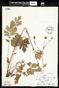 Geum aleppicum Jacquin 746641[1027218]Smith, Welby 45951981-06-30 United States, Minnesota, Steele, Between st. hwy 218 and the Chicago, Milwaukee, St. Paul and Pacific rr tracks in the town of Blooming Prairie; NW1/4 NE Between st. hwy 218 and the Chicago, Milwaukee, St. Paul and Pacific rr tracks in the town of Blooming Prairie; NW1/4 NE1/4 Sec. 25 T105N R19W. 105N 19W 25, 43.87425 -93.053651 |
MIN:Plants | 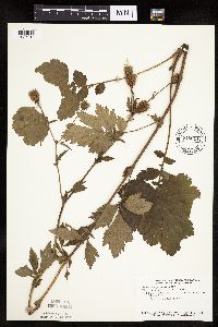 Geum aleppicum Jacquin 746644[1027217]Smith, Welby 49921981-07-21 United States, Minnesota, Mower, Wild Indigo Scientific and Natural Area, ca. 2.5 mi W of Dexter; SW1/4 NE1/4 Sec. 16 T103N R16W;Wild Indigo Scientific Natural Area;103N;16W;16, 43.724883 -92.759467 |
MIN:Plants | 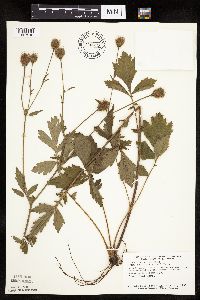 Geum aleppicum Jacquin 746679[1027216]Smith, Welby 48871981-07-18 United States, Minnesota, Wright, Suconnix Wildlife Management Area. Wright Co.; about 5 mi due south of the junction of Interstate hwy 94 and st. hwy 24 in Clearwater; NE1/4 NE1/4 Sec. 34 T122N R27W. 122N 27W 34, 45.338242 -94.058344 |
Google Map
Google Maps is a web mapping service provided by Google that features a map that users can pan (by dragging the mouse) and zoom (by using the mouse wheel). Collection points are displayed as colored markers that when clicked on, displays the full information for that collection. When multiple species are queried (separated by semi-colons), different colored markers denote each individual species.