University of Minnesota
http://www.umn.edu/
612-625-5000
http://www.umn.edu/
612-625-5000
Minnesota Biodiversity Atlas
Bell Museum
Dataset: MIN-Plants
Taxa: Ruscaceae
Search Criteria: excluding cultivated/captive occurrences
Bell Museum plants | |
 MIN:Plants | Maianthemum trifolium (L.) Sloboda 781792[]Smith, Welby 91171984-06-13 United States, Minnesota, Roseau, Pinecreek Peatland, about 12 mi NW of Roseau (town).;Pine Creek Peatland Scientific Natural Area;164N;41W;25, 48.996634 -95.887897 |
MIN:Plants | Maianthemum trifolium (L.) Sloboda 781807[]Smith, Welby 90141984-06-11 United States, Minnesota, Morrison, Pellager Peatland, about 4 mi SW of Pellager (town).;;T133N R31W S36, 46.289663 -94.527456 |
MIN:Plants | Maianthemum trifolium (L.) Sloboda 795448[]Cholewa, A.; Engels, A. 13961987-06-20 United States, Minnesota, Beltrami, Pennington Bog Preserve, ca 1 mi N of Pennington on hwy 10.;Leech Lake Indian Reservation / Pennington Bog Scientific Natural Area;146N;30W;3, 47.494806 -94.474276 |
MIN:Plants | Maianthemum trifolium (L.) Sloboda 795482[]Cholewa, A.; et al. 13691987-06-18 United States, Minnesota, Aitkin, Ca 10 airmiles ESE of Aitkin, ca 1 mi E of Dam Lake.;;047N;25W;36, 46.5169444 -93.4388889 |
MIN:Plants | Maianthemum trifolium (L.) Sloboda 795620[]Wheeler, Gerald 64131982-08-11 United States, Minnesota, Polk, Polk County...Approx. 0.9 mi N of Rte. 1 on an unmarked co. road...on the Nels Vedbraaten farm. T147N R39W sec 4;;147N;39W;04, 47.57911 -95.628954 |
MIN:Plants | Maianthemum trifolium (L.) Sloboda 795621[]Wheeler, Gerald 63621982-08-11 United States, Minnesota, Mahnomen, Mahnomen Co. Approx. 1.5 mi N of the jct of Rt. 113 and Rt. 4, swamp (W side of road on Rt. 4). T143NR 39W sec.19;White Earth Indian Reservation / White Earth State Forest;143N;39W;19, 47.186982 -95.66814 |
MIN:Plants | Maianthemum trifolium (L.) Sloboda 795622[]Wheeler, Gerald 62231982-08-10 United States, Minnesota, Mahnomen, Mahnomen Co. About 2.3 mi N of the jct. of Rt. 4 and an unmarked county road (runs just W of Lambert Lake); W of road.;White Earth Indian Reservation;146N;39W;34, 47.333293 -95.8333 |
MIN:Plants | Maianthemum trifolium (L.) Sloboda 805792[]Almendinger, J. s.n.1987-05-15 United States, Minnesota, Washington, MBS-#193; Forest Lake; T32N R21W NE1/4 NW1/4 of sec.11; .5 mi W Jamaca Ave; 3 mi of town;;032N;21W;11, 45.280025 -92.928778 |
MIN:Plants | Maianthemum trifolium (L.) Sloboda 816977[]Delaney, B. 893291989-09-05 United States, Minnesota, Sherburne, 2.2 mi E of Lake Fremont. SW1/4 NE1/4 sec12, T34N, R26W.;;034N;26W;12, 45.45306 -93.516983 |
MIN:Plants | Maianthemum trifolium (L.) Sloboda 817632[]Cholewa, A. 19911991-06-08 United States, Minnesota, Aitkin, Aitkin Co. Solano [sic] State Forest, 0.8 mi W of Hwy. 65 on West White Pine Road; T45N, R23W, Sec. 20.;Solana State Forest;045N;23W;20, 46.368583 -93.272202 |
MIN:Plants | Maianthemum trifolium (L.) Sloboda 825654[]Cholewa, A.; Engels, A. 19601991-06-01 United States, Minnesota, Aitkin, Savanna State Forest. Aitkin Co, Savanna State Forest, end of logging road ca. 3 mi W of co.hwy.10 (Great River Rd.), ca. 8 mi N of co. hwy.1 Aitkin Co, Savanna State Forest, end of logging road ca. 3 mi W of co.hwy.10 (Great River Rd.), ca. 8 mi N of co. hwy.18, T51N R24W S16.. 051N 24W 16, 46.90533 -93.389223 |
MIN:Plants | Maianthemum trifolium (L.) Sloboda 831346[]Engels, A.; et al. s.n.1992-06-13 United States, Minnesota, Aitkin, Aitkin Co. SE of Starvation Lake. T47N R23W, NE1/4 of SE1.4, Sec.16.;;047N;23W;16, 46.553342 -93.245019 |
MIN:Plants | Maianthemum trifolium (L.) Sloboda 835544[]Monson, Paul 53991983-06-17 United States, Minnesota, Saint Louis, Voyageur's National Park. St. Louis Co. R-19W, T-69N, S-34. Namakan Lake, Hoist Bay. W side;Voyageurs National Park;069N;19W;34, 48.433517 -92.705646 |
MIN:Plants | Maianthemum trifolium (L.) Sloboda 835650[]Cholewa, A.; Engels, A. 21881995-06-01 United States, Minnesota, Aitkin, Aitkin Co. Savanna Portage State Park, about 17 mi NE of McGregor, SW of Loon Lake, second bog, T50N R23W S12 SE1/4;Savanna Portage State Park;050N;23W;12, 46.827346 -93.193316 |
MIN:Plants | Maianthemum trifolium (L.) Sloboda 835664[]Cholewa, A.; et al. 22251995-06-22 United States, Minnesota, Aitkin, Aitkin Co. Savanna Portage State Park, about 17 mi NE of McGregor, sW end of Wolf Lake, T50N R22W S6 NE1/4;Savanna Portage State Park;050N;22W;06, 46.848872 -93.172213 |
MIN:Plants | Maianthemum trifolium (L.) Sloboda 836045[]Smith, Welby 173141990-07-17 United States, Minnesota, Morrison, Camp Ripley Military Reservation. Camp Ripley Military Reservation. Morrison Co.; on the S side of Argonne Road, about 0.5 km S of Ferrell Lake; UTM: 3907 Camp Ripley Military Reservation. Morrison Co.; on the S side of Argonne Road, about 0.5 km S of Ferrell Lake; UTM: 390700E 5106500N T130N R30W NE1/4 of NE1/4 of Sec 2. 130N 30W 2, 46.100229 -94.4217 |
MIN:Plants | Maianthemum trifolium (L.) Sloboda 89795[]Rosendahl, C. 21081909-06-17 United States, Minnesota, Hennepin, Purgatory Swamp;;N;;, 44.90005 -93.501232 |
MIN:Plants | Maianthemum trifolium (L.) Sloboda 89796[]Butters, F.; et al. 34631918-05-18 United States, Minnesota, Hennepin, Purgatory Swamp.;;117N;22W;00, 44.929685 -93.522455 |
MIN:Plants | Maianthemum trifolium (L.) Sloboda 89797[]Rosendahl, C. 24751910-05-30 United States, Minnesota, Hennepin, Ft. Snelling Reservation [old regional park spanning junction of Minnesota and Mississippi rivers], Deephaven Swamp;;028N;23W;, 44.890943 -93.184951 |
MIN:Plants | Maianthemum trifolium (L.) Sloboda 89798[]Bergman, H. 30021914-08-06 United States, Minnesota, Hubbard, Benedict;;143N;32W;35, 47.15729 -94.6957 |
MIN:Plants | Maianthemum trifolium (L.) Sloboda 89799[]Bergman, H. 30021914-08-06 United States, Minnesota, Hubbard, Benedict;;143N;32W;35, 47.15729 -94.6957 |
MIN:Plants | Maianthemum trifolium (L.) Sloboda 89800[]Sandberg, John 10331885-06-00 United States, Minnesota, Chisago, Chisago Lake;;N;;, 45.359099 -92.876532 |
MIN:Plants | Maianthemum trifolium (L.) Sloboda 89801[]Taylor, B. 12941892-06-00 United States, Minnesota, Chisago, Lindstrom;;N;;, 45.378075 -92.847305 |
MIN:Plants | Maianthemum trifolium (L.) Sloboda 89802[]Sheldon, Edmund S23021892-06-00 United States, Minnesota, Aitkin, Nichols;;044N;27W;04, 46.32387 -93.75721 |
MIN:Plants | Maianthemum trifolium (L.) Sloboda 89803[]Juni, B. s.n.1878-00-00 United States, Ohio, Put in Bay;;;;, 41.657593 -82.817228 |
MIN:Plants | Maianthemum trifolium (L.) Sloboda 89804[]Sheldon, Edmund S23431892-06-00 United States, Minnesota, Aitkin, Farm Island Lake;;N;;, 46.422051 -93.772021 |
MIN:Plants | Maianthemum trifolium (L.) Sloboda 89805[]Aiton, G. s.n.1890-05-00 United States, Minnesota, Hennepin, near city [=Minneapolis as per other collections];;029N;24W;25, 44.979965 -93.263836 |
MIN:Plants | Maianthemum trifolium (L.) Sloboda 89806[]Arthur, J.; et al. B2891886-07-23 United States, Minnesota, Saint Louis, Vermilion Lake;;;;, 47.891581 -92.366824 |
MIN:Plants | Maianthemum trifolium (L.) Sloboda 89807[]Cheney, L. s.n.1891-07-02 United States, Minnesota, Cook, Brule River;Judge Magney State Park / North Shore;062N;03E;, 47.816279 -90.050906 |
MIN:Plants | Maianthemum trifolium (L.) Sloboda 89808[]Sandberg, John s.n.1885-06-00 United States, Minnesota, Chisago, Chisago Lake;;N;;, 45.359099 -92.876532 |
MIN:Plants | Maianthemum trifolium (L.) Sloboda 89809[]Ballard, C. s.n.1893-06-00 United States, Minnesota, Cass, L. Kilpatrick;;135N;29W;, 47.003344 -94.454468 |
MIN:Plants | Maianthemum trifolium (L.) Sloboda 89810[]Sandberg, John s.n.1890-06-00 United States, Minnesota, Hennepin, [no further data];;;;, 45 -93.47 |
MIN:Plants | Maianthemum trifolium (L.) Sloboda 459544[]Carlson, Bruce Wypt 6232005-06-23 United States, Minnesota, Saint Louis, St. Louis County ... 7.1 km SSE of Hoyt Lakes, 3.8 km SW of Hush lake, 1.0 km east of USFS Road 346/Moose Line Road ... 10m above and 700m NW of the St. Louis River ... MN DNR Releve 3551 ... T57N R14W SENENE 5. 057N 14W 5, 47.460593 -92.102648 |
MIN:Plants | Maianthemum trifolium (L.) Sloboda 473318[]Lee, Michael MDL16631997-05-30 United States, Minnesota, Stearns, Stearns Co.; At the north end of sylvia Lake 5-3/4 miles north of Melrose; T127N R33W SE1/4 of NW1/4 of NE1/4 sec. 2;;127N;33W;2, 45.749957 -94.8 |
MIN:Plants | Maianthemum trifolium (L.) Sloboda 461219[]Gerdes, Lynden; et al. 24461998-05-21 United States, Minnesota, Cook, Boundary Waters Canoe Area Wilderness / Superior National Forest. T64N R03E S03NENE. Cook County; Superior National Forest, BWCAW. Royal River area, approx. .4 miles NW of Royal Lake On north side of the Royal River.. T064N R03E S3, 48.05743 -90.046129 |
MIN:Plants | Maianthemum trifolium (L.) Sloboda 916956[]Gerdes, Lynden; et al. 57522009-06-26 United States, Minnesota, Cook, Boundary Waters Canoe Area Wilderness / Superior National Forest. T64N R04W S35N1/2NWNW. Cook County, MN. Superior National Forest. Boundary Waters Canoe Area Wilderness. East of Frost Lake along eastern shore of small bog pond...NAD 83 / 663581 / 5317404. 064N 04W 35, 47.9888889 -90.8075 |
MIN:Plants | Maianthemum trifolium (L.) Sloboda 931770[]Smith, Welby R. 204571992-06-20 United States, Minnesota, Wadena, On the north side of a gravel road, about one mile west of Manahga SE of NE of section;;138N;35W;20, 46.7547222 -95.1216667 |
MIN:Plants | Maianthemum trifolium (L.) Sloboda 427908[]Smith, Welby R.; Gerdes, Lynden B. 317642010-06-24 United States, Minnesota, Cook, Just southwest of Sebeka Lake. NW of NE of section;Boundary Waters Canoe Area Wilderness / Superior National Forest;064N;03W;16, 48.0306406 -90.7041179 |
MIN:Plants |  Maianthemum trifolium (L.) Sloboda 960494[1318978]Stork, H.E. 1925-00-00 United States, Minnesota, Itasca |
MIN:Plants | Maianthemum trifolium (L.) Sloboda 515348[]Lee, Michael MDL36312004-07-16 United States, Minnesota, Becker, Two Inlets State Forest / White Earth Indian Reservation. BECKER COUNTY ... Two Inlets State Forest ... Straight River, 4 1/4 mi northeast of Ponsford ... T141N R37W SE1/4 of SW1/4 Sec.24. 141N 37W 24, 47.008105 -95.311489 |
MIN:Plants |  Maianthemum trifolium (L.) Sloboda 960493[1318979]Stork, H.E. 1925-00-00 United States, Minnesota, Itasca |
MIN:Plants |  Maianthemum trifolium (L.) Sloboda 0967464[1368043]T. J. S. Whitfeld 21282019-06-16 United States, Minnesota, Lake, Boundary Waters Canoe Area Wilderness, 0.2 miles from south shore of Insula Lake, in area burned in 2011 Pagami Creek Fire (although this peatland was not burned), 47.896417 -91.282611, 460m |
MIN:Plants |  Maianthemum trifolium (L.) Sloboda 965296[1375965]Lee, Michael MDL52332010-07-03 United States, Minnesota, Cook, 47.85588007 -90.6214729, 564m |
MIN:Plants | Maianthemum trifolium (L.) Sloboda []Bourdaghs, Michael 2022-06-22 United States, Minnesota, Cass, Land O'Lakes State Forest; Site ID: 16CASS276; Visit Number: 2635, 46.94537 -93.83228265 |
MIN:Plants | 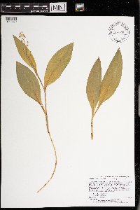 Maianthemum trifolium (L.) Sloboda 972926[1398479]Lee, Michael MDL55642011-06-09 United States, Minnesota, Clearwater, Very gently rolling sand plain north of the Clearwater River, five miles northeast of Bagley., 47.58284434 -95.33686085, 443m |
MIN:Plants | 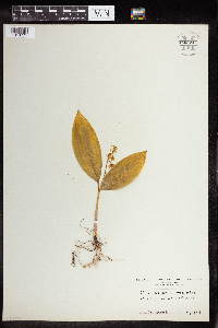 960224[1318771]Heimerl 1924-04-00 Austria |
MIN:Plants | Polygonatum pubescens (Willdenow) Pursh 432322[]Lee, Michael MDL27532000-06-22 United States, Minnesota, Lake, Superior National Forest. Lake County...in the Superior National Forest three miles northeast of Cramer...west of the Caribou River and northeast of Paccini Lake...T59N R6W W1/2 of SW1/4 of SW1/4 Sec. 26.. 059N 06W 26, 47.56738 -91.054497 |
MIN:Plants | Polygonatum pubescens (Willdenow) Pursh 461264[]Gerdes, Lynden; et al. 32481998-09-01 United States, Minnesota, Cook, Boundary Waters Canoe Area Wilderness / Superior National Forest. T64N R03E S08SWNW. Cook County; Superior National Forest, BWCAW. East facing cliff feature, just east of the far east end of Stump Lake..T064N R03E S8, 48.042022 -90.089892 |
MIN:Plants | Polygonatum pubescens (Willdenow) Pursh 487934[]Smith, Welby 168051990-06-12 United States, Minnesota, Lake, Lake County ... Tettegouche State Park, about 3 miles west of Illgen City ... T56N R7W SE1/4 of SE1/4 of Sec 8;North Shore / Tettegouche State Park;056N;07W;08, 47.3477778 -91.2458333 |
MIN:Plants | Polygonatum pubescens (Willdenow) Pursh 616325[]Juhnke, C. 216 CMJ FRO1999-05-13 United States, Minnesota, Goodhue, Frontenac State Park Goodhue County ... below In-Yan-Teopa... T112N R13W SW NE NE 3;Frontenac State Park;112N;13W;3, 44.534992 -92.358902 |
MIN:Plants | Polygonatum pubescens (Willdenow) Pursh 587628[]Jones, George Neville 325571961-06-11 United States, Tennessee, Sevier, along Little Pigeon River, north of Newfound Gap, Gt. Smoky Mts, Sevier Co.;Great Smoky Mountains National Park |
MIN:Plants | Polygonatum pubescens (Willdenow) Pursh 920637[]Smith, Welby 185191991-05-20 United States, Minnesota, Morrison, Camp Ripley Military Reservation. Camp Ripley Military Reservation. Morrison County...About 5.5 km east-southeast of Pillager, on the south side of Pusan Road...UTM: 392000E 512100N. T 133N R 30W SW1/4 of NW1/4 of Sec 23. 133N 30W 23, 46.3088889 -94.4025 |
MIN:Plants | Polygonatum pubescens (Willdenow) Pursh 906957[]Smith, Welby; et al. 309412008-06-18 United States, Minnesota, Cook, Boundary Waters Canoe Area Wilderness / Superior National Forest. Cook County...Eagle Mountain in the Boundary Waters Canoe Area Wilderness, Superior National Forest...T63N R2W NW1/4 of SE1/4 of Sec 34. 063N 02W 34, 47.895 -90.56 |
MIN:Plants | Polygonatum pubescens (Willdenow) Pursh 903381[]Lee, Michael MDL41372005-08-31 United States, Minnesota, Becker, Becker County...southeast of Juggler Lake, six miles southeast of the village of Elbow Lake...T142N R38W SE1/4 Sec. 14;Two Inlets State Forest / White Earth Indian Reservation;142N;38W;14, 47.112207 -95.451347 |
MIN:Plants | Polygonatum pubescens (Willdenow) Pursh 919593[]Smith, Welby 221861993-05-20 United States, Minnesota, Otter Tail, Inman Wildlife Management Area. Otter Tail County...Inman State Wildlife Management Area, about 7 miles south of Deer Creek (town)...T133N R37W SE1/4 of SE1/4 of Sec 33. 133N 37W 33, 46.2847222 -95.3463889 |
MIN:Plants | Polygonatum pubescens (Willdenow) Pursh 912877[]Smith, Welby 242001994-05-31 United States, Minnesota, Koochiching, Franz Jevne State Park. Koochiching County...Franz Jevne State Park. In the Rainy River Valley, about 2 miles northeast of Birchdale... T 160N R 27W SW1/4 of SW1/4 of Sec 26. 160N 27W 26, 48.6427778 -94.0783333 |
MIN:Plants | Polygonatum pubescens (Willdenow) Pursh 464351[]Smith, Michael 6851997-08-27 United States, Minnesota, Koochiching, Voyageurs National Park. Koochiching County...Tom Cod Bay SE;Voyageurs National Park;069N;22W;, 48.4775 -93.1369444 |
MIN:Plants | Polygonatum pubescens (Willdenow) Pursh 226904[]Rosendahl, C.; Butters, F. 45921924-07-05 United States, Minnesota, Cook, near Mineral Center, Cook County;Grand Portage Indian Reservation / North Shore;063N;05E;00, 47.947665 -89.780647 |
MIN:Plants | Polygonatum pubescens (Willdenow) Pursh 264366[]Holzinger, John s.n.1904-05-00 United States, Minnesota, Winona, Vic. of Winona.;;N;;, 44.0333 -91.6333 |
MIN:Plants | Polygonatum pubescens (Willdenow) Pursh 275994[]Grant, Martin 29701929-07-30 United States, Minnesota, Itasca, Schoolcraft Island, Itasca State Park.;Itasca State Park;143N;36W;11, 47.523137 -93.608706 |
MIN:Plants | Polygonatum pubescens (Willdenow) Pursh 351529[]Seashore, Mauritz s.n.1932-05-14 United States, Minnesota, Goodhue, Red Wing.;;113N;14W;, 44.562468 -92.533801 |
MIN:Plants | Polygonatum pubescens (Willdenow) Pursh 354244[]Lakela, Olga 2501a1938-06-26 United States, Minnesota, Saint Louis, On hwy. 4, E of the Gun Club. Duluth.;;N;;, 46.7833 -92.1 |
MIN:Plants | Polygonatum pubescens (Willdenow) Pursh 356657[]Lakela, Olga 28981939-05-31 United States, Minnesota, Saint Louis, Near the Gun Club, on hwy. 4. Duluth.;;N;;, 46.7833 -92.1 |
MIN:Plants | Polygonatum pubescens (Willdenow) Pursh 360391[]Lakela, Olga 35241940-06-12 United States, Minnesota, Carlton, Duquette.;;N;;, 46.369667 -92.553251 |
MIN:Plants | Polygonatum pubescens (Willdenow) Pursh 369427[]Moore, John; et al. 146891941-07-06 United States, Minnesota, Douglas, Douglas County...1 mi. S of Garfield.;;;;, 45.926316 -95.491987 |
MIN:Plants | Polygonatum pubescens (Willdenow) Pursh 380210[]Lakela, Olga 54171943-08-17 United States, Minnesota, Saint Louis, S-facing slope of Hunter's Hill, Duluth.;;N;;, 46.7833 -92.1 |
MIN:Plants | Polygonatum pubescens (Willdenow) Pursh 381142[]Moore, John; Moore, Marjorie 152731942-06-11 United States, Minnesota, Isanti, [no further data];;;;, 45.566613 -93.289917 |
MIN:Plants | Polygonatum pubescens (Willdenow) Pursh 394601[]Butters, F.; Abbe, E. 1911936-06-30 United States, Minnesota, Cook, 2 mi. W of the hwy. from Mineral Center to the border. Cook Co.;Grand Portage Indian Reservation / North Shore;063N;05E;, 47.947321 -89.789505 |
MIN:Plants | Polygonatum pubescens (Willdenow) Pursh 405377[]Lakela, Olga 80461949-05-21 United States, Minnesota, Saint Louis, Prairie Lake.;;N;;, 46.79124 -92.904888 |
MIN:Plants | Polygonatum pubescens (Willdenow) Pursh 407240[]Lakela, Olga 81571949-05-29 United States, Minnesota, Saint Louis, On the Laurentian Divide N of Aurora.;;N;;, 47.5667 -92.5667 |
MIN:Plants | Polygonatum pubescens (Willdenow) Pursh 407437[]Lakela, Olga 96051949-09-01 United States, Minnesota, Saint Louis, Voyageurs State Park. On a small island in Lake Kabetogama.;Voyageurs National Park;N;;, 48.470908 -93.008801 |
MIN:Plants | Polygonatum pubescens (Willdenow) Pursh 419921[]Lakela, Olga 102591950-06-11 United States, Minnesota, Saint Louis, Kabetogama State Forest, Lake Kabetogama.;Kabetogama State Forest;N;;, 48.470908 -93.008801 |
MIN:Plants | Polygonatum pubescens (Willdenow) Pursh 424081[]Emanuel, J. 321946-06-13 United States, Minnesota, Itasca, County: Itasca. Locality: Nashwauk Township - 2 mi. NW of Nashwauk.;;057N;23W;00, 47.414479 -93.26409 |
MIN:Plants | Polygonatum pubescens (Willdenow) Pursh 429852[]Smith, Welby 153101989-06-05 United States, Minnesota, Chisago, Chisago Co.; St. Croix Wild River State Park, about 9 miles N-NW of Taylors Falls; SE1/4 NW1/4 section 17, T 35N R 19W;Wild River State Park;035N;19W;17, 45.522341 -92.746403 |
MIN:Plants | Polygonatum pubescens (Willdenow) Pursh 437363[]Moore, John; Moore, Marjorie 121631939-08-27 United States, Minnesota, Lake of the Woods, Rocky Point, Lake of the Woods.;;163N;34W;, 48.960269 -95.068008 |
MIN:Plants | Polygonatum pubescens (Willdenow) Pursh 441958[]Moore, John; et al. 184551946-05-27 United States, Minnesota, Winona, Garvin Heights. Winona Co.;;;;, 44.029222 -91.666729 |
MIN:Plants | Polygonatum pubescens (Willdenow) Pursh 443494[]Boe, J.; et al. 960605011996-06-05 United States, Minnesota, Aitkin, North of Savanna Lake. SW1/4 of SW1/4 of section;Savanna Portage State Park;051N;22W;31, 46.855586 -93.185702 |
MIN:Plants | Polygonatum pubescens (Willdenow) Pursh 445092[]Moore, John; Huff, N. 194381947-06-03 United States, Minnesota, Beltrami, Red Lake Peninsula, 4 mi. W of Ponemah.;Red Lake Indian Reservation;N;;, 48.102263 -95.056105 |
MIN:Plants | Polygonatum pubescens (Willdenow) Pursh 445636[]Myhre, K. 54371995-05-25 United States, Minnesota, Mahnomen, Mahnomen Co.; Located 1.5 miles northwest of Tulaby Lake; T 143N R 39W NW1/4 of SW1/4 of sec 28;White Earth Indian Reservation / White Earth State Forest;143N;39W;28, 47.172943 -95.625747 |
MIN:Plants | Polygonatum pubescens (Willdenow) Pursh 446251[]Moore, John; Huff, N. 188841946-08-01 United States, Minnesota, Benton, 2 mi. SW of Foley.;;036N;29W;, 45.644208 -93.939002 |
MIN:Plants | Polygonatum pubescens (Willdenow) Pursh 446808[]Moore, John; Huff, N. 191631946-08-30 United States, Minnesota, Beltrami, 4 mi. NW of Ponemah.;Red Lake Indian Reservation;N;;, 48.102263 -95.056105 |
MIN:Plants | Polygonatum pubescens (Willdenow) Pursh 456873[]Myhre, K. 47911994-05-20 United States, Minnesota, Itasca, Itasca County; located one half mile south of Caribou Lake; T 58N R 26W NE1/4 of NW1/4 of Sec 15;Chippewa National Forest;058N;26W;15, 47.513851 -93.632661 |
MIN:Plants | Polygonatum pubescens (Willdenow) Pursh 456879[]Myhre, K. 48571994-05-27 United States, Minnesota, Itasca, Itasca Co.; located on the island in Rice Lake; T 148N R 27W NW1/4 of SW1/4 of Sec 1;Chippewa National Forest / Leech Lake Indian Reservation;148N;27W;1, 47.663567 -94.053697 |
MIN:Plants | Polygonatum pubescens (Willdenow) Pursh 462841[]Lakela, Olga 144661952-06-30 United States, Minnesota, Saint Louis, Midway Road, near Nopeming.;;N;;, 47.491038 -92.525739 |
MIN:Plants | Polygonatum pubescens (Willdenow) Pursh 463157[]Lakela, Olga 140401952-05-30 United States, Minnesota, Saint Louis, Nopeming.;;N;;, 46.706549 -92.27435 |
MIN:Plants | Polygonatum pubescens (Willdenow) Pursh 466688[]Kruse, K. 009 KMK1994-05-20 United States, Minnesota, Goodhue, Frontenac State Park. Goodhue Co.; T: 112N R: 13W Sec: 2 Quarter Sec: N 1/2;Frontenac State Park;112N;13W;2, 44.534004 -92.339261 |
MIN:Plants | Polygonatum pubescens (Willdenow) Pursh 475362[]Smith, Welby 151491989-05-26 United States, Minnesota, Benton, Benlacs Wildlife Management Area. Benton County...Benlacs State Wildlife Management Area, about 7 miles southeast of Foley; SE1/4 SE1/4 section 12, T 36N R 28W. 036N 28W 12, 45.6208333 -93.7630556 |
MIN:Plants | Polygonatum pubescens (Willdenow) Pursh 482525[]Lee, Michael MDL13121996-06-26 United States, Minnesota, Kanabec, Kanabec Co.; Vasaloppett Ski Area 1.5 miles west of Warman; T41N R24W NE1/4 SE1/4 Sec. 1;;041N;24W;1, 46.062796 -93.316573 |
MIN:Plants | Polygonatum pubescens (Willdenow) Pursh 504862[]Smith, Welby 187851991-06-11 United States, Minnesota, Aitkin, Aitkin County...on the N shore of Mille Lacs Lake, about 12 mi S of Aitken [sic]...T45N R27W NE1/4 of SW1/4 of Sec 26;Wealthwood State Forest;045N;27W;26, 46.3508333 -93.7152778 |
MIN:Plants | Polygonatum pubescens (Willdenow) Pursh 514423[]Smith, Welby 186071991-05-23 United States, Minnesota, Cass, Cass Co.; about 5 mi NE of Pillager, in Pillsbury State Forest; T134N R30W SW1/4 of NE1/4 of Sec 26;Pillsbury State Forest;134N;30W;26, 46.391065 -94.423196 |
MIN:Plants | Polygonatum pubescens (Willdenow) Pursh 519840[]Smith, Welby 185611991-05-21 United States, Minnesota, Todd, Todd Co.; Staples State Wildlife Management Area, about 4 miles S of Staples (town); T133N R33W SW1/4 of NE1/4 of Sec 36;Staples Wildlife Management Area;133N;33W;36, 46.2936096 -94.7861099 |
MIN:Plants | Polygonatum pubescens (Willdenow) Pursh 525908[]Lakela, Olga 188931955-07-20 United States, Minnesota, Saint Louis, Vermillon River woods, at Gold Mine camp, S of Crane Lake.;;N;;, 48.2833 -92.4667 |
MIN:Plants | Polygonatum pubescens (Willdenow) Pursh 560815[]Ownbey, Gerald; Anderson, Henry 26951959-06-21 United States, Minnesota, Clearwater, Just W of Itasca State Park. Low place adjacent to forest access road.;;143N;37W;, 47.192326 -95.357833 |
MIN:Plants | Polygonatum pubescens (Willdenow) Pursh 572556[]Moore, John 257121961-08-07 United States, Minnesota, Anoka, N side of Cedar Creek Bog, Cedar Creek Natural History Area.;Cedar Creek National History Area;034N;23W;, 45.40217 -93.199397 |
MIN:Plants |  Polygonatum pubescens (Willdenow) Pursh 592381[]Westkaemper, Remberta s.n.1964-05-00 United States, Minnesota, Stearns, Stearns Co. St. Benedict's [College] woods, St. Joseph.;;124N;29W;, 45.564772 -94.317966 |
MIN:Plants | Polygonatum pubescens (Willdenow) Pursh 607198[]Grafstrom, M. 511968-06-14 United States, Minnesota, Pine, Pine Co. T41N R17W NW1/4 sec.29;Saint Croix State Park;041N;17W;29, 46.004959 -92.519295 |
MIN:Plants | Polygonatum pubescens (Willdenow) Pursh 616479[]Moore, John; Moore, Marjorie 561969-05-23 United States, Minnesota, Crow Wing, Along a short trail to Mallard Lake, off circle trail.;Crow Wing Natural Area;044N;28W;22, 46.493111 -94.193193 |
MIN:Plants | Polygonatum pubescens (Willdenow) Pursh 670779[]Heitlinger, M. 5661972-06-01 United States, Minnesota, McLeod, In woods along the E bank of Buffalo Creek.;Schaefer Prairie, The Nature Conservancy; T115N R29W S34, 44.724106 -94.305158 |
MIN:Plants | Polygonatum pubescens (Willdenow) Pursh 686859[]Wheeler, Gerald; Glaser, Paul 12851977-05-15 United States, Minnesota, Itasca, Ca. 6 mi. SW of Grand Rapids.;;055N;26W;32, 47.116565 -93.672261 |
MIN:Plants | Polygonatum pubescens (Willdenow) Pursh 708320[]Ownbey, Gerald 63731979-08-11 United States, Minnesota, Houston, Dorer Memorial Hardwood State Forest. Houston Co. Minnesota Memorial Hardwood State Forest. Rte. 76, 5.5 mi. S of its jct. with hwy. 16, 1 mi. E of Houston. Houston Co. Minnesota Memorial Hardwood State Forest. Rte. 76, 5.5 mi. S of its jct. with hwy. 16, 1 mi. E of Houston. N-facing bluffs of Badger Creek.. 103N 06W 27, 43.692516 -91.546296 |
Google Map
Google Maps is a web mapping service provided by Google that features a map that users can pan (by dragging the mouse) and zoom (by using the mouse wheel). Collection points are displayed as colored markers that when clicked on, displays the full information for that collection. When multiple species are queried (separated by semi-colons), different colored markers denote each individual species.