University of Minnesota
http://www.umn.edu/
612-625-5000
http://www.umn.edu/
612-625-5000
Minnesota Biodiversity Atlas
Bell Museum
Dataset: MIN-Plants
Taxa: Sarraceniaceae
Search Criteria: excluding cultivated/captive occurrences
Bell Museum plants | |
 MIN:Plants | []Timothy J. S. Whitfeld 34612022-07-20 United States, Minnesota, Saint louis, Sax-Zim Bog area, Alborn Fen off Tremblay Road, 47.012487 -92.572451, 412m |
MIN:Plants | []Timothy J. S. Whitfeld 36212023-07-06 United States, Minnesota, Marshall, Agassiz National Wildlife Refuge, Agassiz Wilderness Area, along south shore of Whiskey Lake, 4.8 miles north of main administration building, 48.3717 -95.9653, 347m |
MIN:Plants | 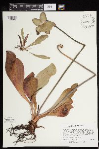 472934[1293496]Lee, Michael MDL17881997-07-01 United States, Minnesota, Stearns, Stearns Co.; Six miles south of St. Augusta; on the south side of a shallow, marly lake; T122N R28W SE1/4 of SE1/4 of SE1/4 Sec. 12. 122N 28W 12, 45.390121 -94.151578 |
MIN:Plants |  431901[1329922]Smith, Welby 168021990-06-12 United States, Minnesota, Lake, North Shore / Tettegouche State Park. Lake County...Tetagouch [sic] State Park; at the southeast end of Tetagouch [sic] Lake, about 4 miles west of Illgen City...T 56N R 7W SE1/4 of SE1/4 of Sec 7. 056N 07W 7, 47.3438889 -91.2638889 |
MIN:Plants | 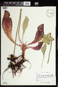 907808[1349435]Lee, Michael MDL37352004-07-21 United States, Minnesota, Becker, Becker County...Two Inlets State Forest, four mi south of Two Inlets...One Acre Lake...T141N R36W SE1/4 of SW1/4 Sec 26;Two Inlets State Forest;141N;36W;26, 46.994142 -95.205425 |
MIN:Plants | 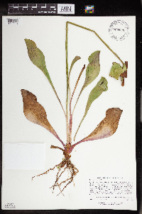 920870[1349446]Lee, Michael MDL35082003-07-28 United States, Minnesota, Todd, Todd County...between Beck and Buckhorn Lakes, 4.5 miles southwest of Lincoln, nine miles northeast of Browerville... T131N R32W SW1/4 of SW1/4 of NW1/4 Sec. 15, NW1/4 of NW1/4 of SW1/4 Sec. 15. 131N 32W 15, 46.158138 -94.700035 |
MIN:Plants | 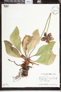 453844[1329920]Smith, Welby 158291989-07-20 United States, Minnesota, Mille Lacs, Mille Lacs Kathio State Park. Mille Lacs County...Mille Lacs Kathio State Park, about 5 miles northwest of Onamia...NE1/4 SE1/4 sec. 10, T 42N R 27. Wof Minn. Rte. 200, 8.2 miles E of its jct. with U.S. Rte. 59 at Mahnomen.. 042N 27W 10, 46.1372223 -93.7272186 |
MIN:Plants | 778135[1349586]Coffin, Barbara; et al. 81-451981-08-10 United States, Wisconsin, Ashland, Ashland County...T51N, R2W; NW 1/4, Sec. 35. Bog Lake, Madeline Island;Apostle Islands National Lakeshore;T051N R02W S35, 46.85 -90.5833 |
MIN:Plants | 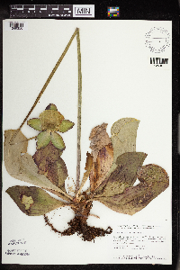 459345[1349356]Smith, Welby 143281988-06-25 United States, Minnesota, Aitkin, Long Lake Conservation Center, about 7.5 mi W-NW of McGregor. N of Long Lake. SW1/4 NW1/4 of section;<No data>;048N;25W;13, 46.6477778 -93.46 |
MIN:Plants | 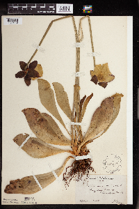 121878[1349445]Rosendahl, C. 21991909-07-01 United States, Minnesota, Hennepin, Purgatory Swamp;;117N;22W;, 44.90005 -93.501232 |
MIN:Plants | 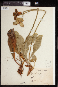 121879[1349433]Bergman, H. 30461914-08-14 United States, Minnesota, Hubbard, Benedict;Paul Bunyan State Forest;143N;32W;35, 47.15729 -94.6957 |
MIN:Plants | 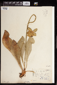 121880[1349408]Aiton, G. s.n.1889-08-00 United States, Minnesota, Hennepin, [no further data];;;;, 45 -93.47 |
MIN:Plants | 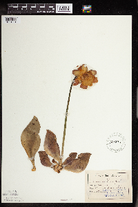 121881[1351001]Aiton, G. s.n.1878-05-00 United States, Minnesota, Hennepin, [no further data];;;;, 45 -93.47 |
MIN:Plants | 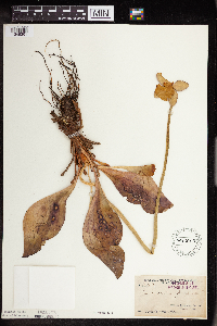 121882[1349361]Arthur, J.; et al. B2881886-07-23 United States, Minnesota, Saint Louis, Vermilion Lake;;;;, 47.891581 -92.366824 |
MIN:Plants | 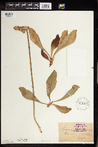 121883[1349443]Oestlund, O. 58-11886-07-13 United States, Minnesota, Ramsey, Ramsey Co.;;;;, 45.016016 -93.090884 |
MIN:Plants | 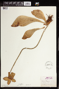 121884[1349432]Herrick, C. s.n.1876-07-00 United States, Minnesota, Hennepin, Minneapolis;;N;;, 44.979965 -93.263836 |
MIN:Plants | 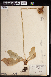 121885[1349439]Taylor, B. 711891-08-00 United States, Minnesota, Pope, Glenwood;;N;;, 45.648982 -95.401248 |
MIN:Plants | 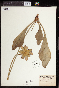 121886[1349396]Burglehaus, F. s.n.1892-07-00 United States, Minnesota, Hennepin, Minneapolis;;N;;, 44.979965 -93.263836 |
MIN:Plants | 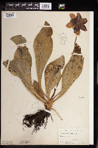 121887[1349444]Moyer, Lycurgus; Aiton, G. s.n.1897-06-25 United States, Minnesota, Ramsey, New Brighton;;030N;23W;, 45.065521 -93.201891 |
MIN:Plants | 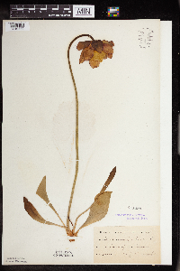 121888[1349440]Kassube, J. s.n.1878-06-00 United States, Minnesota, Hennepin, Minneapolis;;N;;, 44.979965 -93.263836 |
MIN:Plants | 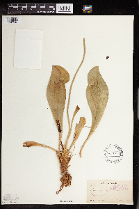 121889[1349343]Sandberg, John 3191891-06-00 United States, Minnesota, Hennepin, Minneapolis;;N;;, 44.979965 -93.263836 |
MIN:Plants | 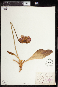 121890[1349360]Sandberg, John s.n.1886-06-00 United States, Minnesota, Chisago, Centre City;;034N;20W;, 45.389814 -92.821151 |
MIN:Plants | 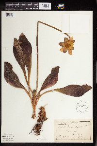 121891[1349402]Ballard, C. B12761893-06-00 United States, Minnesota, Cass, Gull Lake;;N;;, 46.446379 -94.35099 |
MIN:Plants | 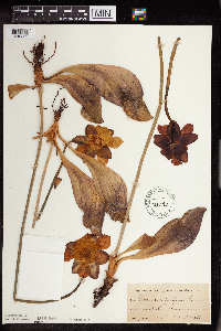 121892[1349362]Roberts, Thomas s.n.1878-06-00 United States, Minnesota, Saint Louis, Duluth;;N;;, 46.7833 -92.1 |
MIN:Plants | 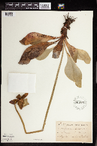 121893[1349369]Taylor, B. T11161891-08-00 United States, Minnesota, Pope, Glenwood;;N;;, 45.648982 -95.401248 |
MIN:Plants | 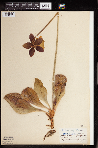 121894[1349373]Aiton, G. s.n.1891-07-00 United States, Minnesota, Clearwater, Lake Itasca;Itasca State Park;143N;36W;, 47.197458 -95.201964 |
MIN:Plants | 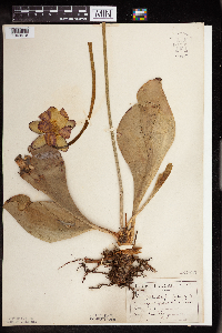 121895[1349416]Sandberg, John s.n1890-06-00 United States, Minnesota, Hennepin, [no further data];;;;, 45 -93.47 |
MIN:Plants | 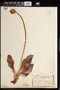 121896[1349418]Sheldon, Edmund S23381892-06-00 United States, Minnesota, Aitkin, Farm Island Lake.;;N;;, 46.422051 -93.772021 |
MIN:Plants |  265599[1349385]Stevenson, J. 1101912-07-01 United States, Minnesota, Beltrami, Bemidji;;N;;, 47.536341 -94.82277 |
MIN:Plants |  265600[1349386]Stevenson, J. 1101912-07-01 United States, Minnesota, Beltrami, Bemidji;;N;;, 47.536341 -94.82277 |
MIN:Plants |  276138[1349370]Grant, Martin 28041929-07-17 United States, Minnesota, Clearwater, Itasca Park; Iron Springs; NW-NE33 T144 R36.;Iron Springs Bog Scientific Natural Area;144N;36W;33, 47.246103 -95.244665 |
MIN:Plants |  276900[1349377]Huff, N. 1551914-07-14 United States, Minnesota, Lake, South Kawishiwi R.;Superior National Forest;N;;, 47.824084 -91.725158 |
MIN:Plants | 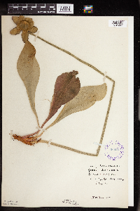 288406[1349417]Johnson, R. s.n.1914-07-03 United States, Minnesota, Hennepin, Purgatory Swamp.;;N;;, 44.90005 -93.501232 |
MIN:Plants | 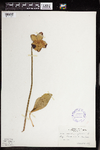 306864[1349378]Cottrell, R. s.n.1935-06-20 United States, Minnesota, Cass, Hackensack;;140N;30W;, 46.930792 -94.520552 |
MIN:Plants | 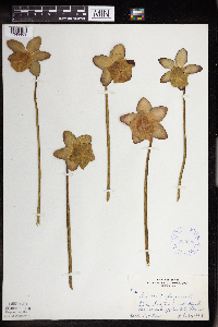 333628[1349403]Orr, L. 261929-07-30 United States, Minnesota, Cook, SE1/4 S12 T64 2W [this locality just sw of Poplar Lake];Superior National Forest;064N;02W;12, 48.046734 -90.508674 |
MIN:Plants | 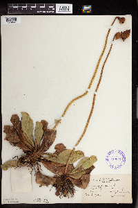 349062[1349441]Nielsen, E. 23591933-09-14 United States, Minnesota, Scott, 1 mi. W of Savage.;;N;;, 44.765236 -93.374591 |
MIN:Plants | 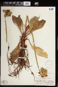 354573[1349426]Lakela, Olga 26421938-07-30 United States, Minnesota, Saint Louis, on hwy 4, about 5 mi s of Biwabik;;N;;, 47.460607 -92.340179 |
MIN:Plants | 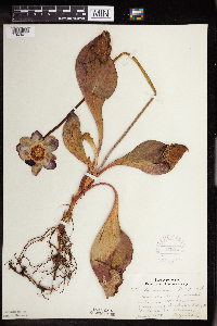 356263[1349411]Lakela, Olga 29831939-06-18 United States, Minnesota, Saint Louis, 18 mi. N of Duluth, Hwy. 53.;;N;;, 47.041046 -92.473248 |
MIN:Plants | 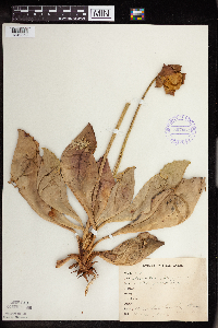 357062[1349359]Anonymous 871912-08-11 United States, Minnesota, Saint Louis, Meadowlands;;N;;, 47.071884 -92.732416 |
MIN:Plants | 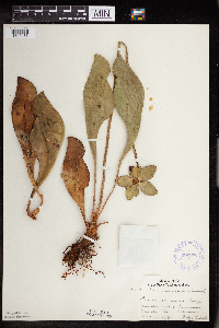 360700[1349436]Lakela, Olga 41091940-08-13 United States, Minnesota, Carlton, SE of Barnum;;N;;, 46.503001 -92.688531 |
MIN:Plants | 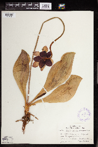 362734[1349401]Lakela, Olga 36981940-07-05 United States, Minnesota, Cook, at the Maya's Place, Sea Gull Lake;Boundary Waters Canoe Area Wilderness / Superior National Forest;063N;03W;, 48.1333 -90.9333 |
MIN:Plants | 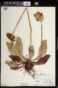 367053[1349434]Moore, John; Moore, Marjorie 103521938-08-27 United States, Minnesota, Saint Louis, N shore of the NW arm of Auto Lake.;Superior National Forest;N;;, 48.270719 -92.216797 |
MIN:Plants | 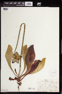 368839[1349419]Lakela, Olga 44251941-06-29 United States, Minnesota, Saint Louis, Normanna Twp, ca. 14 mi. N of Duluth.;;N;;, 46.985947 -92.106579 |
MIN:Plants | 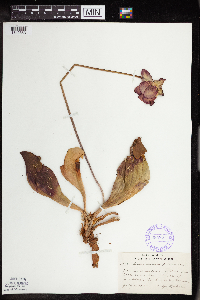 385821[1349363]Lakela, Olga 55781944-07-02 United States, Minnesota, Saint Louis, Swamp bordering Sturgeon Lake, 25 mi n of Hibbing.;George Washington State Forest;N;;, 47.789032 -92.937689 |
MIN:Plants | 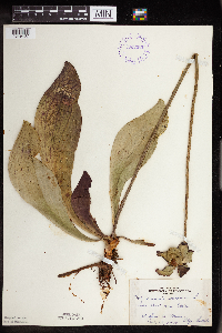 393350[1349407]Lakela, Olga 70491947-07-29 United States, Minnesota, Saint Louis, Near Skibo.;;;;, 47.485479 -91.994337 |
MIN:Plants | 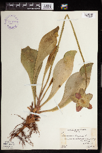 401130[1349437]Butters, F.; Abbe, E.; Abbe, L. 2951937-07-05 United States, Minnesota, Cook, near second small lake e of outlet of Mountain Lake, T65N R2E.;Boundary Waters Canoe Area Wilderness / Superior National Forest;065N;02E;, 48.10737 -90.224172 |
MIN:Plants | 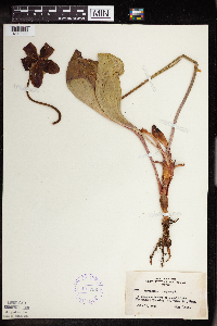 407838[1349330]Lakela, Olga 87081949-07-13 United States, Minnesota, Saint Louis, Fredenburg Twp;;052N;15W;, 46.987037 -92.191099 |
MIN:Plants | 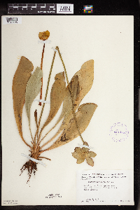 412475[1349406]Moore, John; Moore, Marjorie 112241939-07-28 United States, Minnesota, Lake of the Woods, Near the source of Pine Creek, Angle Inlet.;Northwest Angle;168N;34W;, 49.353711 -95.002845 |
MIN:Plants | 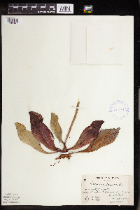 419311[1349428]Briggs, John De Q.; Briggs, Marjorie 861945-08-07 United States, Minnesota, Cook, small pond 3 mi s of Sawbill Lake and e of Sawbill Trail; T62N R4W.;Superior National Forest;062N;04W;, 47.849549 -90.876181 |
MIN:Plants | 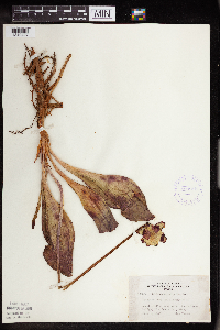 420915[1349427]Lakela, Olga 105821950-07-01 United States, Minnesota, Saint Louis, about 1 mi e of St. Louis River bridge;;N;;, 47.583298 -92.478541 |
MIN:Plants | 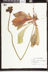 441291[1329921]Smith, Welby 194411991-07-15 United States, Minnesota, Aitkin, Savanna Portage State Park. Aitkin Co.; Savanna Portage State Park, along path around the north side of Loon Lake; Aitkin Co.; Savanna Portage State Park, along path around the north side of Loon Lake; T 50N R 23W SE1/4 of SE1/4 of Sec 12. 050N 23W 12, 46.8280563 -93.191391 |
MIN:Plants | 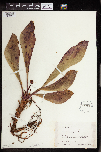 445080[1349387]Moore, John 193971947-05-28 United States, Minnesota, Pine, 3 mi. SE of Hinckley.;;N;;, 45.980618 -92.900147 |
MIN:Plants |  445217[1349389]Moore, John 175021945-06-29 United States, Minnesota, Kanabec, 7 mi. SE of Mora.;;N;;, 45.805189 -93.190895 |
MIN:Plants |  445796[1349346]Moore, John; Huff, N. 183261945-10-05 United States, Minnesota, Pine, 3 mi w of Pine City;;039N;22W;, 45.82605 -93.030877 |
MIN:Plants |  445901[1349420]Moore, John; Huff, N. 179271945-07-24 United States, Minnesota, Morrison, 1 mi. S of Cushing.;;N;;, 46.12521 -94.576956 |
MIN:Plants |  446524[1349352]Moore, John; Huff, N. 185861946-06-12 United States, Minnesota, Itasca, on the n boundary, 1/2 mi from camp on lookout tower trail, Scenic State Park.;Scenic State Park;N;;, 47.715773 -93.56297 |
MIN:Plants | 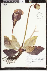 447090[1329923]Gerdes, Lynden 29631998-07-17 United States, Minnesota, Cook, Boundary Waters Canoe Area Wilderness / Superior National Forest. T64N R03E S02SWSW. Cook Co.; Superior National Forest, BWCAW. West of Royal Lake and south of the Royal River; boggy dra T64N R03E S02SWSW. Cook Co.; Superior National Forest, BWCAW. West of Royal Lake and south of the Royal River; boggy drainage inlet.. T064N R03E S2, 48.05632 -90.023108 |
MIN:Plants | 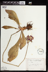 481120[1349364]Lakela, Olga 163171953-06-28 United States, Minnesota, Saint Louis, S28-T50-R21, Prairie Lake area.;;050N;21W;28, 46.79124 -92.904888 |
MIN:Plants | 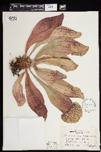 494465[1293495]Huff, N. s.n.1941-08-18 United States, Minnesota, Beltrami, Big Bog - Upper Red Lake;Red Lake Indian Reservation;N;;, 48.13107 -94.766637 |
MIN:Plants | 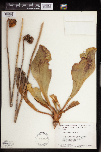 507082[1349348]Moore, John; et al. 209871951-06-07 United States, Minnesota, Itasca, Itasca County...n of cabins along the observation tower road, Scenic State Park.;Scenic State Park;;;, 47.715773 -93.56297 |
MIN:Plants |  514430[1349350]Smith, Welby 162571989-08-29 United States, Minnesota, Chisago, Chisago Co.; about 3 mi N of Almelund; SW1/4 NE1/4 sec.12, T35N R20W;;035N;20W;12, 45.5347214 -92.7791672 |
MIN:Plants |  520843[1349423]Myhre, K. 5164A1994-07-05 United States, Minnesota, Itasca, Itasca Co.; located 2.7 miles southwest of the town of Bigfork; small bog lake; T 60N R 26W SW1/4 of SW1/4 of Sec 5;Chippewa National Forest;060N;26W;5, 47.704615 -93.681578 |
MIN:Plants |  524431[1349442]Benner, J. s.n.1931-07-08 United States, Minnesota, Itasca, S of Grand Rapids;;N;;, 47.2349 -93.564359 |
MIN:Plants |  525704[1349438]Lakela, Olga 182461954-08-14 United States, Minnesota, Saint Louis, Turtle River S of Friday Bay.;Boundary Waters Canoe Area Wilderness / Superior National Forest;N;;, 48.187674 -91.797627 |
MIN:Plants | 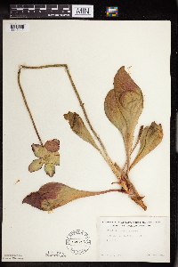 526786[1349412]Lakela, Olga 177451954-07-03 United States, Minnesota, Saint Louis, Dark Lake, S of Iron Lake.;Boundary Waters Canoe Area Wilderness / Superior National Forest;066N;13W;11, 48.219513 -91.957793 |
MIN:Plants | 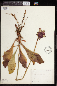 526807[1349404]Lakela, Olga 176121954-06-24 United States, Minnesota, Saint Louis, Tamarack River w end of Burntside Lake;Superior National Forest;063N;14W;36, 47.9357 -91.982299 |
MIN:Plants | 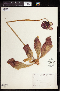 526808[1349400]Lakela, Olga 155691954-06-23 United States, Minnesota, Saint Louis, Second Lake, Echo Trail, nw of Ely.;Superior National Forest;N;;, 47.9 -91.8667 |
MIN:Plants | 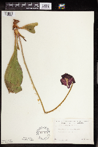 527079[1349413]Lakela, Olga 175381954-06-22 United States, Minnesota, Saint Louis, St. Louis County...Echo Trail near the Portage River, N of Ely;Superior National Forest;065N;14W;24, 47.9 -91.8667 |
MIN:Plants |  527096[1349414]Lakela, Olga 177161954-06-30 United States, Minnesota, Saint Louis, Finberg Lake, N of Floodwood Lake.;;N;;, 47.168272 -93.035201 |
MIN:Plants |  527521[1349375]Lakela, Olga 182461954-08-14 United States, Minnesota, Saint Louis, on Turtle River s of Friday Bay;;N;;, 48.1833 -91.7833 |
MIN:Plants |  529138[1349410]Lakela, Olga 194971955-09-12 United States, Minnesota, Saint Louis, Sand Lake n of Virginia;Superior National Forest;060N;18W;, 48.483546 -92.838098 |
MIN:Plants |  533005[1349344]Lakela, Olga; Elwell, M. 205941956-07-26 United States, Minnesota, Saint Louis, s of Ash River Jnc. on hwy 53.;Kabetogama State Forest;N;;, 48.41713 -92.789044 |
MIN:Plants |  533164[1349336]Lakela, Olga; Elwell, M. 200111956-06-24 United States, Minnesota, Saint Louis, off hwy 24, Pelican Lake, Orr;Kabetogama State Forest;N;;, 48.07265 -92.934264 |
MIN:Plants |  551514[1349334]Cotter, Shirley 7771948-07-08 United States, Minnesota, Clearwater, Garrison Point Bog, Itasca Park;Itasca State Park;143N;36W;, 47.197458 -95.201964 |
MIN:Plants |  586463[1349333]Moore, John; et al. 265321963-09-06 United States, Minnesota, Isanti, along the n end of Beckman Lake, Cedar Creek Natural History Area.;Cedar Creek National History Area;034N;23W;, 45.42632 -93.184371 |
MIN:Plants |  607523[1349388]Westkaemper, Remberta s.n.1967-07-00 United States, Minnesota, Stearns, Stearns Co. Rockville;;124N;29W;, 45.475278 -94.334722 |
MIN:Plants |  607678[1349429]Westkaemper, Remberta s.n.1968-06-00 United States, Minnesota, Stearns, Stearns Co. Rockville;;124N;29W;, 45.475278 -94.334722 |
MIN:Plants | 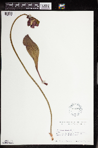 611483[1349374]Lammers, Roberta s.n.1967-06-11 United States, Minnesota, Isanti, sw of Beckman Lake, Cedar Creek Natural History Area.;Cedar Creek National History Area;034N;23W;, 45.418006 -93.195185 |
MIN:Plants | 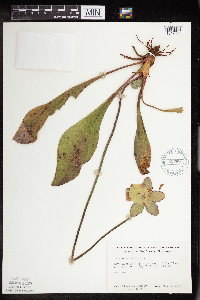 627686[1349391]Ownbey, Gerald 45451972-07-09 United States, Minnesota, Cass, Cass Co. Boy River Bog, 3 mi E of Boy River. N1/2 NE1/4 Sec.23 T143N R27W.;Chippewa National Forest;143N;27W;23, 47.101979 -94.06127 |
MIN:Plants | 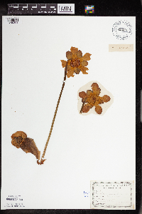 655203[1349353]Gage Jr., Addison 121876-06-08 United States, Minnesota, Hennepin, Minneapolis;;N;;, 44.979965 -93.263836 |
MIN:Plants | 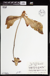 669810[1349431]Wheeler, Gerald s.n.1975-07-07 United States, Minnesota, Saint Louis, 3 mi. SE of the jct. of the main road to Dunka Mine (Erie Mining Co.) and the Reserve Mining Co, r.r. tracks; near Babb 3 mi. SE of the jct. of the main road to Dunka Mine (Erie Mining Co.) and the Reserve Mining Co, r.r. tracks; near Babbitt.. N, 47.708528 -91.944602 |
MIN:Plants |  673646[1349354]Borchard, Alma s.n.1939-07-04 United States, Minnesota, Itasca, Deer River; about 10 mi n of the city.;;N;;, 47.334197 -93.787874 |
MIN:Plants |  676657[1349349]Malone, Virginia Lee 281946-07-06 United States, Minnesota, Anoka, 8 mi e of Bethel at Cedar Creek Bog.;Cedar Creek National History Area;034N;23W;, 45.404652 -93.100988 |
MIN:Plants |  686972[1349447]Wheeler, Gerald; Glaser, Paul 13971977-05-22 United States, Minnesota, Itasca, Site 18. NE1/4 Sec. 7, T56N, R26W; ca. 10.5 mi. NW of Grand Rapids.;;056N;26W;7, 47.3476 -93.692122 |
MIN:Plants |  687068[1329919]Wheeler, Gerald; Glaser, Paul 14941977-05-29 United States, Minnesota, Itasca, Site 10. NW1/4 NW1/4 Sec. 21, T55N, R26W; ca. 5 mi. W of Grand Rapids.;;055N;26W;21, 47.232383 -93.649481 |
MIN:Plants | 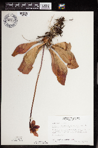 687269[1349340]Wheeler, Gerald; Glaser, Paul 16971977-06-20 United States, Minnesota, Itasca, Itasca County...Coll. Site 39...SE1/4 SE1/4 Sec. 29, T57N, R25W; approx. 10 mi. north of Grand Rapids.;;057N;25W;29, 47.381921 -93.530214 |
MIN:Plants | 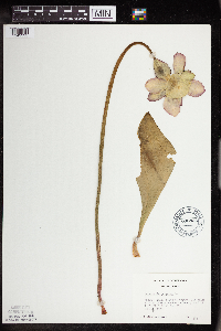 695834[1349335]Clemants, Steven 13251978-06-20 United States, Minnesota, Crow Wing, About 3 mi n of Cuyuna, 1.5 mi e of co. rd. 6 on co. rd. 11. T136N R26W Sec.26.;;136N;26W;26, 46.56499 -93.921425 |
MIN:Plants | 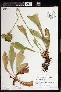 696936[1349384]Siemers, Ross 421977-07-12 United States, Minnesota, Stearns, Stearns Co. Rockville Tamarack Bog, near Cold Spring. T123N, R29W, Sec. 17.;Rockville Tamarack Bog;123N;29W;17, 45.469043 -94.355202 |
MIN:Plants | 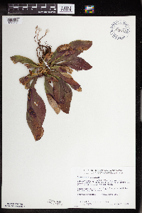 698120[1349393]Wheeler, Gerald; Glaser, Paul 29301978-06-08 United States, Minnesota, Beltrami, SW14 NW1/4 Sec. 14, T156N, R31W; ca. 12 mi. N of the Waskish Airport on Rte. 72, ca. 2 mi. W of the road.;Red Lake Peatland Scientific Natural Area;156N;31W;14, 48.277335 -94.5536 |
MIN:Plants |  698208[1349405]Wheeler, Gerald; Glaser, Paul 30081978-06-21 United States, Minnesota, Beltrami, Red Lake Peatland Scientific Natural Area. Red Lake Peatland. SW1/4 NW1/4 Sec. 25, T156N, R32W; ca. 12.5 mi. NW of the Waskish Airport. Ovoid Islands area; ca. 1 Red Lake Peatland. SW1/4 NW1/4 Sec. 25, T156N, R32W; ca. 12.5 mi. NW of the Waskish Airport. Ovoid Islands area; ca. 1 1/4 mi. SW of Camp No. I.. 156N 32W 25, 48.287244 -94.82516 |
MIN:Plants |  698607[1349395]Wheeler, Gerald; Glaser, Paul 33381978-08-31 United States, Minnesota, Beltrami, Red Lake Peatland Scientific Natural Area. Red Lake Peatland SNA; ca. 12.5 mi. NW of the Waskish Airport. Ovoid Islands Area; ca. 1 1/4 mi. SW of Camp No. I. Sit Red Lake Peatland SNA; ca. 12.5 mi. NW of the Waskish Airport. Ovoid Islands Area; ca. 1 1/4 mi. SW of Camp No. I. Site 21.. 156N 32W 36, 48.287244 -94.82516 |
MIN:Plants |  698640[1349394]Wheeler, Gerald; Glaser, Paul 33711978-08-31 United States, Minnesota, Koochiching, Red Lake Peatland Scientific Natural Area. Koochiching Co.; Site 86. NW1/4 NW1/4 Sec. 16, T156N, R29W; ca. 8.5 mi. E of Rte. 72 and 10.5 mi. NNE of the Waskish Airport. Koochiching Area.. 156N 29W 16, 48.33103 -94.37074 |
MIN:Plants |  698997[1349372]Sather, Nancy; et al. 1141976-06-21 United States, Minnesota, Lake, Lake Co, Phenology plot 1; SE1/4 S36 T61N R11W;Superior National Forest;061N;11W;36, 47.725837 -91.672181 |
MIN:Plants | 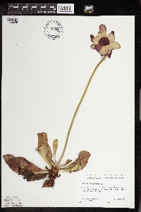 700531[1349345]Ownbey, Gerald 58641978-06-14 United States, Minnesota, Clearwater, Along co. rt. 5, 5.5 mi n of Clearbrook. T150N R37W SE1/4 Sec.30.;;150N;37W;30, 47.782628 -95.441272 |
MIN:Plants | 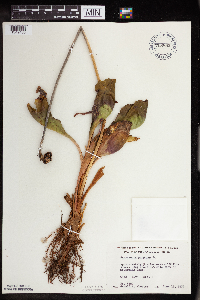 708892[1349430]Wheeler, Gerald 38801979-06-13 United States, Minnesota, Pine, Pine Co. Approx. 3 mi E of Willow River. About 0.5 mi E of McCormick Lake. T44N, R19W, Sec. 8.;;044N;19W;8, 46.309787 -92.772203 |
MIN:Plants | 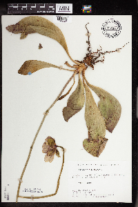 715331[1349328]Farrell, P. 441979-06-28 United States, Minnesota, Beltrami, Lake Bemidji Bog SNA: 1 mi nw of Lake Bemidji, N1/2 of NW1/4 of sec.24, T147N R33W.;Lake Bemidji State Park;147N;33W;24, 47.536135 -94.815118 |
MIN:Plants | 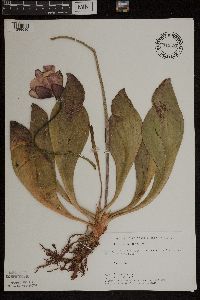 715587[1299690]Keller, C. 371979-06-28 United States, Minnesota, Beltrami, Pennington Orchid Bog SNA: 1 mi n of Pennington, NW1/4 sec.3 T146N R30W.;Leech Lake Indian Reservation / Pennington Bog Scientific Natural Area;146N;30W;3, 47.494806 -94.474276 |
MIN:Plants | 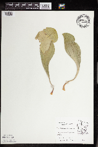 717784[1349376]Thompson, J. s.n.1979-08-05 United States, Minnesota, Hubbard, e of Lake Alice;;N;;, 47.195358 -95.10652 |
MIN:Plants | 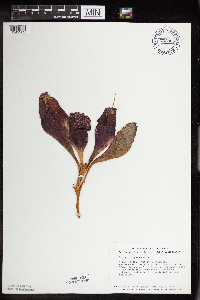 723955[1349382]Smith, Welby 22211980-05-24 United States, Minnesota, Saint Louis, T51N, R19W, NW1/4 NW1/4 Sec. 12. Arlberg Bog. 1/4 mi. S of Co. Rd. 8; 10.5 mi. E of its jct. with Co. Rd. 73 in Floodw T51N, R19W, NW1/4 NW1/4 Sec. 12. Arlberg Bog. 1/4 mi. S of Co. Rd. 8; 10.5 mi. E of its jct. with Co. Rd. 73 in Floodwood.. 051N 19W 12, 46.920172 -92.69032 |
MIN:Plants | 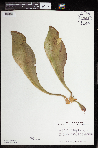 724082[1349383]Smith, Welby 21801980-05-24 United States, Minnesota, Saint Louis, T52N, R21W, SE1/4 Sec. 21. On the S side of Hwy. 2, ca. 5 mi. NW of its jct. with Hwy. 53 in Floodwood.;;052N;21W;21, 46.97618 -93.005586 |
Google Map
Google Maps is a web mapping service provided by Google that features a map that users can pan (by dragging the mouse) and zoom (by using the mouse wheel). Collection points are displayed as colored markers that when clicked on, displays the full information for that collection. When multiple species are queried (separated by semi-colons), different colored markers denote each individual species.