University of Minnesota
http://www.umn.edu/
612-625-5000
http://www.umn.edu/
612-625-5000
Minnesota Biodiversity Atlas
Bell Museum
Dataset: MIN-Plants
Taxa: Triadenum
Search Criteria: excluding cultivated/captive occurrences
Bell Museum plants | |
 MIN:Plants | Triadenum fraseri (Spach) Gleason 585296[]Ownbey, Gerald 35801963-07-27 United States, Minnesota, Hubbard, Darling Pond, E shore; T143N R35W NW1/4 Sec. 6;Itasca State Park;143N;35W;6, 47.232454 -95.161387 |
MIN:Plants | Triadenum fraseri (Spach) Gleason 586522[]Moore, John; et al. 265291963-09-06 United States, Minnesota, Isanti, Along the W side of Beckman Lake, Cedar Creek Natural History Area;Cedar Creek National History Area;034N;23W;, 45.424031 -93.186345 |
MIN:Plants | Triadenum fraseri (Spach) Gleason 607459[]Ownbey, Gerald; Hsi, Yu-tseng [Eugene] 42081968-08-19 United States, Minnesota, Aitkin, Aitkin Co. 1 mi W of McGregor;;048N;24W;, 46.615904 -93.307319 |
MIN:Plants | Triadenum fraseri (Spach) Gleason 611488[]Lammers, Roberta s.n.1967-07-21 United States, Minnesota, Isanti, S of Beckman Lake, Cedar Creek Natural History Area;Cedar Creek National History Area;034N;23W;, 45.418127 -93.184886 |
MIN:Plants | Triadenum fraseri (Spach) Gleason 616436[]Moore, John; Moore, Marjorie 4071969-08-07 United States, Minnesota, Crow Wing, Crow Wing Natural History Area, E shore of Chandler Lake, SW1/4 S22, Garrison Twp;Crow Wing Natural Area;044N;28W;22, 46.278961 -93.86289 |
MIN:Plants | Triadenum fraseri (Spach) Gleason 670240[]Hansen, B.; Hansen, JoAnn 36311975-08-27 United States, Minnesota, Cook, 12 mi N of Lutsen at the W-most end of Tait Lake; T62N R3W Sec. 28;Superior National Forest;062N;03W;28, 47.702831 -90.680212 |
MIN:Plants | Triadenum fraseri (Spach) Gleason 687527[]Wheeler, Gerald; Glaser, Paul 19691977-07-09 United States, Minnesota, Itasca, Collection Site no. 41, ca. 11 mi NNE of Grand Rapids; SW1/4 SW1/4 Sec. 22 T57N R25W;;057N;25W;22, 47.40128 -93.511758 |
MIN:Plants | Triadenum fraseri (Spach) Gleason 687618[]Wheeler, Gerald; Glaser, Paul 20631977-07-13 United States, Minnesota, Itasca, Collection Site no. 42, near Releve' 10, ca. 12.5 mi NNW of Grand Rapids; SW1/4 SE1/4 Sec. 18 T57N R25W;Chippewa National Forest;057N;25W;18, 47.416629 -93.575713 |
MIN:Plants | Triadenum fraseri (Spach) Gleason 687721[]Wheeler, Gerald; Glaser, Paul 21671977-07-20 United States, Minnesota, Itasca, Collection Site no. 130, ca. 8.5 mi NNW of Grand Rapids; NW1/4 NW1/4 Sec. 1 T56N R26W;;056N;26W;1, 47.369412 -93.595716 |
MIN:Plants | Triadenum fraseri (Spach) Gleason 697780[]Ownbey, Gerald 52451976-08-06 United States, Minnesota, Clearwater, Itasca State Park, Mink Lake; T143N R36W SE1/4 Sec. 7;Itasca State Park;143N;36W;7, 47.216898 -95.286535 |
MIN:Plants | Triadenum fraseri (Spach) Gleason 698290[]Wheeler, Gerald; Glaser, Paul 30901978-06-30 United States, Minnesota, Beltrami, Coll. Site no. 36, ca. 13 mi N of the Waskish Airport on rte 72, ca. 0.25 mi E of the road.;Red Lake Peatland Scientific Natural Area;156N;30W;7, 48.258248 -94.54324 |
MIN:Plants | Triadenum fraseri (Spach) Gleason 698508[]Wheeler, Gerald; Glaser, Paul 33121978-08-30 United States, Minnesota, Beltrami, Coll. Site no. 1, ca. 14.5 mi N of the Waskish Airport on rte 72, ca. 0.5 mi W of the road.;Red Lake Peatland Scientific Natural Area;156N;31W;1, 48.359967 -94.564698 |
MIN:Plants | Triadenum fraseri (Spach) Gleason 698684[]Sather, Nancy; et al. 4411977-06-30 United States, Minnesota, Saint Louis, Plot G18, St. Louis Co. NW1/4 NW1/4 Sec. 8 T57N R13W;Superior National Forest;057N;13W;08, 47.43677 -92.144224 |
MIN:Plants | Triadenum fraseri (Spach) Gleason 698977[]Sather, Nancy; et al. 2721976-07-19 United States, Minnesota, Saint Louis, St. Louis Co. Plot T22; SW1/4 SW1/4 Sec. 5 T57N R13W;Superior National Forest;057N;13W;05, 47.451822 -92.015855 |
MIN:Plants | Triadenum fraseri (Spach) Gleason 698978[]Sather, Nancy; et al. 4861977-08-15 United States, Minnesota, Saint Louis, St. Louis Co. Plot G18...NW1/4 NW1/4 Sec. 8 T57N R13W;Superior National Forest;057N;13W;08, 47.437099 -92.015849 |
MIN:Plants | Triadenum fraseri (Spach) Gleason 701411[]Dorio, J. 8441977-09-01 United States, Minnesota, Morrison, Co.: Morrison ... Sandhill Crane Meadow, 4.5 mi W of Buckman on hwy 34 ... T39N R31W Sec. 3 and 4;Crane Meadows National Wildlife Refuge;039N;31W;, 45.904403 -94.188579 |
MIN:Plants | Triadenum fraseri (Spach) Gleason 704587[]Smith, Welby 16381979-08-16 United States, Minnesota, Wabasha, 150 meters due W of co. rd 84, along N end of pond; T109N R9W NW1/4 NW1/4 Sec. 18;;109N;09W;18, 44.243599 -91.939111 |
MIN:Plants | Triadenum fraseri (Spach) Gleason 704588[]Smith, Welby 16391979-08-16 United States, Minnesota, Wabasha, 100 meters due W of co. rd 84; T109N R9W SE1/4 NW1/4 Sec. 18;;109N;09W;18, 44.243599 -91.939111 |
MIN:Plants | Triadenum fraseri (Spach) Gleason 712088[]Smith, Welby 18301979-08-14 United States, Minnesota, Wright, N side of st. hwy 55, 2.0 mi E of its jnc with co. rd 8 in Maple Lake; T120N R26W NE1/4 NW1/4 Sec. 9;;120N;26W;9, 45.222449 -93.962996 |
MIN:Plants | Triadenum fraseri (Spach) Gleason 717890[]Lustig, K. 311977-08-09 United States, Minnesota, Anoka, Anoka Co. Carlos Avery Wildlife Area, 3/4 mi N of hwy 18 on Zodiac Road; T33N R22W Sec. 4;Carlos Avery Wildlife Management Area;033N;22W;4, 45.377243 -93.090642 |
MIN:Plants | Triadenum fraseri (Spach) Gleason 717891[]Lustig, K. 1071978-06-24 United States, Minnesota, Cook, Eagle Mountain, along trail to mountain; T63N R2W Sec. 34;Boundary Waters Canoe Area Wilderness / Superior National Forest;063N;02W;34, 47.897568 -90.564383 |
MIN:Plants | Triadenum fraseri (Spach) Gleason 717901[]Lustig, K. 101977-07-08 United States, Minnesota, Cook, Along shore of Two Island Lake; T62N R1W Sec. 4;Superior National Forest;062N;01W;4, 47.881853 -90.457966 |
MIN:Plants | Triadenum fraseri (Spach) Gleason 722504[]Lustig, K. 10001979-08-23 United States, Minnesota, Anoka, Anoka County...Boot Lake SNA, 18 mi SE of Cambridge; Sec. 17, 18, 19, 20 T33N R22W;Boot Lake Scientific Natural Area;033N;22W;00, 45.34066 -93.08146 |
MIN:Plants | Triadenum fraseri (Spach) Gleason 724496[]Smith, Welby 30591980-07-28 United States, Minnesota, Saint Louis, St. Louis County...On the E side of Purvis Lake...T62N R13W NW1/4 SW1/4 NW1/4 Sec. 28;Purvis Lake-Ober Foundation Scientific Natural Area;062N;13W;28, 47.823966 -91.996687 |
MIN:Plants | Triadenum fraseri (Spach) Gleason 724943[]Smith, Welby 27221980-07-09 United States, Minnesota, Saint Louis, On the S side of co. rd 8, ca. 7.5 mi due E of Floodwood; T51N R19W NW1/4 SW1/4 NE1/4 Sec. 9;;051N;19W;9, 46.928999 -92.760661 |
MIN:Plants | Triadenum fraseri (Spach) Gleason 728877[]Wheeler, Gerald 53531980-07-18 United States, Minnesota, Ramsey, Ramsey Co.; Roseville, Little Lake Josephine [between Lake Josephine and Lake Owasso], on the E side of the lake; T29N R Ramsey Co.; Roseville, Little Lake Josephine [between Lake Josephine and Lake Owasso], on the E side of the lake; T29N R23W Sec. 2. 029N 23W 2, 45.034228 -93.14839 |
MIN:Plants | Triadenum fraseri (Spach) Gleason 729515[]Phelps, V. 2061980-08-05 United States, Minnesota, Pine, Pine Co. St. Croix Natural Area, 21 mi E of Hinckley; NW1/4 NE1/4 NE1/4 Sec. 32 T41N R17W;Saint Croix State Park;041N;17W;32, 45.990677 -92.51917 |
MIN:Plants | Triadenum fraseri (Spach) Gleason 729579[]Converse, C. 5991980-08-13 United States, Minnesota, Pine, Pine Co. St. Croix Natural Area, 21 mi E of Hinckley; SE1/4 NE1/4 Sec. 5 T40N R17W;Saint Croix State Park;040N;17W;5, 45.980424 -92.496049 |
MIN:Plants | Triadenum fraseri (Spach) Gleason 729932[]Converse, C. 6791980-07-28 United States, Minnesota, Pine, Pine Co. Kettle River Natural Area, 5.5 mi E of Hinckley; NW1/4 NW1/4 Sec. 23 T41N R20W;Kettle River Scientific Natural Area / Sandstone National Wildlife Refuge;041N;20W;23, 46.013408 -92.841832 |
MIN:Plants | Triadenum fraseri (Spach) Gleason 730272[]Phelps, V. 1461980-08-25 United States, Minnesota, Chisago, Goose Creek Natural Area, 5 mi SE of Rush City; NE1/4 NW1/4 Sec. 18 T36N R20W;Wild River State Park;036N;20W;18, 45.612945 -92.891839 |
MIN:Plants | Triadenum fraseri (Spach) Gleason 745161[]Smith, Welby 53871981-08-11 United States, Minnesota, Carlton, Ca. 2.5 mi S of Wright; Sec. 22 T48N R21W;;048N;21W;22, 46.629294 -92.989599 |
MIN:Plants | Triadenum fraseri (Spach) Gleason 747290[]Galatowitsch, S. 7301982-09-06 United States, Minnesota, Wabasha, [no further data];Kellogg-Weaver Dunes Scientific Natural Area / Kellogg-Weaver Dunes, The Nature Conservancy;109N;09W;, 44.2331079 -91.9172451 |
MIN:Plants | Triadenum fraseri (Spach) Gleason 758990[]Smith, Welby 74071982-08-20 United States, Minnesota, Mower, Cartney Wildlife Management Area. Cartney State Wildlife Management Area, ca. 5 mi NNW of Le Roy, adjacent to the West Branch Little Iowa River; NW1/4 NE1 Cartney State Wildlife Management Area, ca. 5 mi NNW of Le Roy, adjacent to the West Branch Little Iowa River; NW1/4 NE1/4 Sec. 5 T101N R14W. 101N 14W 5, 43.580049 -92.539234 |
MIN:Plants | Triadenum fraseri (Spach) Gleason 759155[]Smith, Welby 70031982-07-30 United States, Minnesota, Mower, Brandt-Larson State Wildlife Management Area, ca. 4 mi NE of Lyle, along Otter Creek; NE1/4 SW1/4 Sec. 16 T101N R17W;Brandt-Larson Wildlife Management Area;101N;17W;16, 43.55122 -92.879061 |
MIN:Plants | Triadenum fraseri (Spach) Gleason 759184[]Smith, Welby 70331982-07-31 United States, Minnesota, Wright, Ca. 6 mi SSE of Clearwater; NW1/4 NW1/4 Sec. 31 T122N R26W;;122N;26W;31, 45.338371 -94.011425 |
MIN:Plants | Triadenum fraseri (Spach) Gleason 772860[]Boe, J. 17561980-08-15 United States, Minnesota, Lake of the Woods, Cecil's Landing on Roosevelt Road, NE1/4 S4, T35W, T160N;Beltrami Island State Forest;160N;35W;4, 48.8 -95.0833 |
MIN:Plants | Triadenum fraseri (Spach) Gleason 774142[]Monson, Paul 52521982-08-11 United States, Minnesota, Saint Louis, Voyageurs National Park, R19W, T69N, NE1/4 S18, Agnes Lake, Kabetogama peninsula, SW end of lake;Voyageurs National Park;069N;19W;18, 48.470908 -93.008801 |
MIN:Plants | Triadenum fraseri (Spach) Gleason 774483[]Monson, Paul 56911983-07-30 United States, Minnesota, Saint Louis, Voyageurs National Park, R18W, T68N, SW1/4 S4, Net Lake;Voyageurs National Park;068N;18W;4, 48.404611 -92.661405 |
MIN:Plants | Triadenum fraseri (Spach) Gleason 780377[]Ownbey, Gerald 70451985-07-18 United States, Minnesota, Aitkin, Aitkin Co. T47N, R25W, S36, NW1/4 of the NE1/4, just NE of Dam Lake, Kimberly Twp, elev. 1225 ft.;;047N;25W;36, 46.516963 -93.441167 |
MIN:Plants | Triadenum fraseri (Spach) Gleason 780467[]Ownbey, Gerald 69271984-07-07 United States, Minnesota, Clearwater, T144N, R38W, on line between sections 5 & 6, S side of MN Rte 200, 1.2 mi SE of its jnc with Co Rte 7 in the town of Roy T144N, R38W, on line between sections 5 & 6, S side of MN Rte 200, 1.2 mi SE of its jnc with Co Rte 7 in the town of Roy Lake. 144N 38W , 47.312952 -95.533572 |
MIN:Plants | Triadenum fraseri (Spach) Gleason 787115[]Maxson, George-Ann s.n.1981-07-25 United States, Minnesota, Itasca, Pug Hole Bog on the S end of Pug Hole Lake; E1/2 SW1/4 Sec. 24 T57N R26W;;057N;26W;24, 47.407462 -93.588795 |
MIN:Plants | Triadenum fraseri (Spach) Gleason 789707[]Smith, Welby 103531985-05-31 United States, Minnesota, Jackson, Ca. 1 mi SE of Petersburg, bluff in the Des Moines River Valley; NW1/4 SE1/4 Sec. 27 T101N R34W;;101N;34W;27, 43.522695 -94.904434 |
MIN:Plants | Triadenum fraseri (Spach) Gleason 795624[]Wheeler, Gerald 62751982-08-10 United States, Minnesota, Mahnomen, Mahnomen Co. Approx. 2.5 mi NE of Island Lake, at jnc of rt 15 and rt 24; T146N R39W Sec. 3-4;White Earth Indian Reservation;146N;39W;, 47.491766 -95.604842 |
MIN:Plants | Triadenum fraseri (Spach) Gleason 816706[]Welling, C. 90-1011990-08-28 United States, Minnesota, Ramsey, Immediately N of MN State Hwy 96 and 0.6 km E of Hwy 61, S12, White Bear Twp. Ramsey Co.;;030N;22W;12, 45.095973 -92.997347 |
MIN:Plants | Triadenum fraseri (Spach) Gleason 828432[]Dana, R. 901091990-08-16 United States, Minnesota, Kittson, Kittson Co.; SE1/4 NE1/4 Sec.34 T162N R45W;;162N;45W;34, 48.8129997 -96.4550018 |
MIN:Plants | Triadenum fraseri (Spach) Gleason 831035[]Cholewa, A. 20861992-08-22 United States, Minnesota, Aitkin, Aitkin Co. Savanna State Forest, Camp Lakes, W (main) lake, ca. 2 mi N of hwy.6 on co.rd.75. T49N R23W Sec.13 NW1/4.;Savanna State Forest;049N;23W;13, 46.734194 -93.207338 |
MIN:Plants | Triadenum fraseri (Spach) Gleason 831672[]Harris, Fred 921761992-08-16 United States, Minnesota, Pennington, Pennington Co. Interbeach zone of Glacial Lake Agassiz; NW1/4 SW1/4 Sec.21 T153N R44W;;153N;44W;21, 48.057073 -96.316862 |
MIN:Plants | Triadenum fraseri (Spach) Gleason 831737[]Harris, Fred 922151992-08-18 United States, Minnesota, Red Lake, Red Lake Co. Crane WMA; NE1/4 SW1/4 Sec 13 T151N R40W;Crane Wildlife Management Area (Red Lake County);151N;40W;13, 47.899226 -95.720288 |
MIN:Plants | Triadenum fraseri (Spach) Gleason 832305[]Morley, T. 17461992-10-03 United States, Minnesota, Dakota, Dakota Co.; old pastureland S of home and barn at 24090 Northfield Blvd, S side of Hampton; SW1/4 sec.17, T113N, R18W;;113N;18W;17, 44.590521 -93.009892 |
MIN:Plants | Triadenum fraseri (Spach) Gleason 833695[]Loope, W. 1311983-08-11 United States, Minnesota, Cook, Grand Portage National Monument. Cook Co, R-5E, T-64N, SW1/4, S-21, The Cascades of the Pigeon River.;Grand Portage National Monument / North Shore;064N;05E;21, 47.999682 -89.760688 |
MIN:Plants | Triadenum fraseri (Spach) Gleason 834325[]Monson, Paul 56911983-07-30 United States, Minnesota, Saint Louis, Voyageur's National Park. St. Louis Co. R-18W, T-68N, SW1/4, S-4. Net Lake. Beaver dam; at N end;Voyageurs National Park;T068N R18W S4, 48.404611 -92.661405 |
MIN:Plants | Triadenum fraseri (Spach) Gleason 834326[]Monson, Paul 52521982-08-11 United States, Minnesota, Saint Louis, Voyageur's National Park. St. Louis Co. R-19W, T-69N, NE1/4, S-18. Agnes Lake, Kabetogama peninsula; SW end of lake;Voyageurs National Park;069N;19W;18, 48.470908 -93.008801 |
MIN:Plants | Triadenum fraseri (Spach) Gleason 836237[]Cholewa, A. 24231995-08-11 United States, Minnesota, Aitkin, Aitkin Co. Savanna Portage State Park, about 17 mi NE of McGregor, Wolf Lake along N shore, T51N R22W S32 SW1/4 of SW1/4;Savanna Portage State Park;051N;22W;32, 46.857397 -93.158715 |
MIN:Plants | Triadenum fraseri (Spach) Gleason 839205[]Boe, J. 930820021993-08-20 United States, Minnesota, Cass, Cass Co.; releve 93-44; T140N R28W SE1/4 of SW1/4 of Sec 35.;;140N;28W;35, 46.893007 -94.187764 |
MIN:Plants | Triadenum fraseri (Spach) Gleason 840403[]Smith, Welby 135381987-07-22 United States, Minnesota, Washington, Washington Co. About 5 mi NE of Hugo; SE1/4 NE1/4 sec.12, T31N R21W;;031N;21W;12, 45.1880569 -92.9024963 |
MIN:Plants | Triadenum fraseri (Spach) Gleason 841125[]Smith, Welby 134521987-07-10 United States, Minnesota, Washington, Washington Co. Corries Swamp, about 8 mi W of Marine on St. Croix; NE1/4 SE1/4 sec.34, T32N R21W;;032N;21W;34, 45.205555 -92.9397202 |
MIN:Plants | Triadenum fraseri (Spach) Gleason 841770[]Smith, Welby 137261987-08-05 United States, Minnesota, Washington, About 5 mi W of Marine on St. Croix. NE1/4 NW1/4 of section;;031N;20W;08, 45.188378 -92.8653681 |
MIN:Plants | Triadenum fraseri (Spach) Gleason 493470[]Lee, Michael MDL30942001-08-15 United States, Minnesota, Lake, Superior National Forest. Lake County ... Superior National Forest, south of U.S. Forest Service Road #358 and west of Crooked Lake, six miles north of Cramer ... lake which forms the headwaters of small stream draining into Thunderbird Lake ... T59N R6W NE1/4 of SW1/4 of NE1/4 Sec.8. 059N 06W 8, 47.608974 -91.118243 |
MIN:Plants | Triadenum fraseri (Spach) Gleason 440608[]Gerdes, Lynden 29831998-07-18 United States, Minnesota, Cook, Boundary Waters Canoe Area Wilderness / Superior National Forest. T64N R03E S03NESE. Cook County ... Superior National Forest, BWCAW. West of Royal Lake, just north and adjacent to the Royal River.. T064N R03E S3, 48.057476 -90.046009 |
MIN:Plants | Triadenum virginicum Rafinesque 510877[]US Nat. Arboretum staff s.n.1981-00-00 United States, New Jersey, Ocean, Ocean Co. |
MIN:Plants | Triadenum fraseri (Spach) Gleason 510908[]Gerdes, Lynden; et al. 28001998-07-01 United States, Minnesota, Cook, T65N R01E S27NENW. Cook County ... Superior National Forest, BWCAW. Shores of Clearwater Lake; north side of lake.;Boundary Waters Canoe Area Wilderness / Superior National Forest;065N;01E;27, 48.083795 -90.312959 |
MIN:Plants | Triadenum fraseri (Spach) Gleason 510907[]Gerdes, Lynden 29831998-07-18 United States, Minnesota, Cook, Boundary Waters Canoe Area Wilderness / Superior National Forest. T64N R03E S03NESE. Cook County ... Superior National Forest, BWCAW. West of Royal Lake, just north and adjacent to the Royal River..T064N R03E S3, 48.057476 -90.046009 |
MIN:Plants | Triadenum fraseri (Spach) Gleason 920291[]Smith, Welby 182831990-08-31 United States, Minnesota, Morrison, Camp Ripley Military Reservation. Camp Ripley Military Reservation. Morrison County...On the E side of Luzon Road...Goose Pond...UTM: 389600E 5108500N T 131N R 30W NW1/4 of NW1/4 of Sec 35. 131N 30W 35, 46.1230556 -94.4288889 |
MIN:Plants | Triadenum fraseri (Spach) Gleason 454622[]Myhre, K. 71881997-08-13 United States, Minnesota, Kanabec, Kanabec County ... White Lily Lake. Located 17 miles northeast of the town of Mora ... T 42N R 22W NW1/4 of NE1/4 of Sec 34. 042N 22W 34, 46.078648 -93.107176 |
MIN:Plants | Triadenum fraseri (Spach) Gleason 477235[]Harris, Fred 991691999-07-20 United States, Minnesota, Nicollet, Nicollet County ... T111N R27W, SW1/4 of NE1/4 of NW1/4 Sec. 20;;111N;27W;20, 44.406211 -94.099739 |
MIN:Plants | Triadenum fraseri (Spach) Gleason 909718[]Lee, Michael MDL45222007-08-10 United States, Minnesota, Wadena, Wadena County...2.5 miles west-southwest of Oylen...T136N R33W S1/2 of SW1/4 of NE1/4 Sec. 28...UTM: 5158533N 358102E;;T136N R33W S28, 46.564794 -94.853432 |
MIN:Plants | Triadenum fraseri (Spach) Gleason 906927[]Smith, Welby; et al. 310952008-08-06 United States, Minnesota, Saint Louis, Boundary Waters Canoe Area Wilderness / Superior National Forest. St. Louis County ... Along the shore of Meat Lake in the Boundary Waters Canoe Area Wilderness, Superior National Forest ... T63N R14W SE1/4 of SE1/4 of Sec 22.. 063N 14W 22, 47.9197222 -92.0980556 |
MIN:Plants | Triadenum fraseri (Spach) Gleason 480918[]Lee, Michael MDL22441998-07-08 United States, Minnesota, Carver, Carver County ... Marsh Lake Hunting Club 2-1/2 miles south of Victoria ... T116N R24W SE1/4 of SE1/4 Sec. 26;;116N;24W;26, 44.82698 -93.67245 |
MIN:Plants | Triadenum fraseri (Spach) Gleason 924720[]Smith, Welby 212231992-08-04 United States, Minnesota, Hennepin, About 1.5 miles southeast of Chanhassen. NW1/4 of NE1/4 of section.;;116N;22W;19, 44.8463889 -93.5077778 |
MIN:Plants | Triadenum fraseri (Spach) Gleason 931155[]Gerdes, Lynden B. 62202010-09-14 United States, Minnesota, Cook, Approximately 6.84 miles NNW of Grand Marais, MN along the western shore of Binagami Lake. NESENWNE of section;Superior National Forest;062N;01E;19, 47.8475 -90.3663889 |
MIN:Plants | Triadenum fraseri (Spach) Gleason 935339[]Smith, Welby R. 333572011-08-16 United States, Minnesota, Beltrami, About 16 air miles northwest of Waskish. SE of SE of section;Red Lake Peatland Scientific Natural Area;156N;32W;12, 48.3407333 -94.6895667 |
MIN:Plants | Triadenum fraseri (Spach) Gleason 937042[]Smith, Welby R. 322272010-09-03 United States, Minnesota, Saint Louis, Along the Whiteface River about 6 miles east of Cotton. NE of NE of section;;054N;16W;10, 47.1808761 -92.348627 |
MIN:Plants | Triadenum fraseri (Spach) Gleason 937110[]Smith, Welby R. 322972010-09-05 United States, Minnesota, Lake, Along County Road 7 (Cramer Road) about 1.5 miles west of the Cook County Line. SW of SE of section [collector provided invalid longitude; estimated instead];Superior National Forest;061N;06W;02, 47.7919444 -91.0499972 |
MIN:Plants | Triadenum fraseri (Spach) Gleason 429353[]Smith, Welby R.; Lee, Michael D. 320342010-08-07 United States, Minnesota, Cook, On the north side of Tote Lake. NW of NW of section;Boundary Waters Canoe Area Wilderness / Superior National Forest;063N;02W;13, 47.9441647 -90.5307146 |
MIN:Plants | Triadenum fraseri (Spach) Gleason 473280[]Smith, Welby R. 318912010-07-27 United States, Minnesota, Dakota, Along the Vermillion River about 7 miles southeast of Hastings. SE of NE of section;;114N;16W;21, 44.6682304 -92.7360854 |
MIN:Plants | 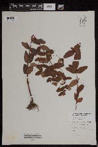 Triadenum virginicum Rafinesque 953745[1294835]anonymous s.n.1896-08-01 United States, Massachusetts, Essex, Marblehead Neck |
MIN:Plants | 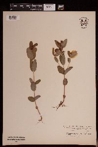 Triadenum fraseri (Spach) Gleason 953320[1292717]Stork, H. E. s.n.1925-00-00 United States, Minnesota, Itasca |
MIN:Plants | 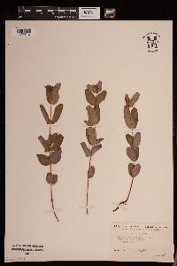 Triadenum fraseri (Spach) Gleason 953319[1292716]KenKnight, Glenn s.n.1932-00-00 United States, Minnesota, Clearwater |
MIN:Plants | 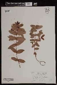 Triadenum virginicum Rafinesque 953763[1294722]Putnam, Mary P. s.n.1905-00-00 United States, Massachusetts, [no further data] |
MIN:Plants | 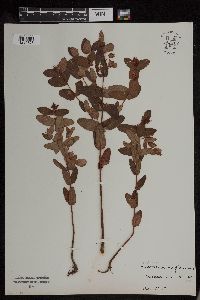 Triadenum virginicum Rafinesque 953762[1294723]M. M. s.n. United States, Massachusetts, Barnstable |
MIN:Plants | 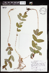 Triadenum fraseri (Spach) Gleason 965453[1356317]Lee, Michael MDL53952010-08-26 United States, Minnesota, Cook, 48.03602093 -90.51814836, 578m |
MIN:Plants | 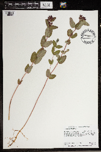 Triadenum fraseri (Spach) Gleason 966828[1359489]Anderson, Derek S. 28092018-08-23 United States, Minnesota, Roseau, Roseau River WMA. About 16 km south-southeast of Caribou. North side of Cty. Rd. 7, approximately 4 km east of the Kittson/Roseau County Line., 48.85 -96.35 |
MIN:Plants | 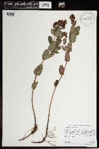 Triadenum fraseri (Spach) Gleason 967151[1359810]Rowe, Erika R. ERR6182009-08-21 United States, Minnesota, Beltrami, 130 meters east of Beltrami County Hwy 39; 3.3 miles south of Pennington., 47.44 -94.48, 399m |
MIN:Plants | Triadenum fraseri (Spach) Gleason MPCA_Dummy11[]Mark Gernes 2021-07-29 United States, Minnesota, Cass, Remer State Forest & Chippewa National Forest, Collected as part of the US Environmental Protection Agency National Wetland Condition Assessment (EPA siteID NWC21-MN-10002) and MN Pollution Control Agency MN Wetland Condition Assessment (MPCA siteID 16CASS212), 47.11343731 -93.84047667 |
MIN:Plants | Triadenum fraseri (Spach) Gleason MPCA_Dummy43[]Michael Bourdaghs 2021-08-05 United States, Minnesota, Douglas, Collected as part of the US Environmental Protection Agency National Wetland Condition Assessment (EPA siteID NWC21-MN-10018) and MN Pollution Control Agency MN Wetland Condition Assessment (MPCA siteID 21DOUG018), 45.95555926 -95.35094798 |
MIN:Plants | Triadenum fraseri (Spach) Gleason MPCA_Dummy14[]Mark Gernes 2021-08-11 United States, Minnesota, Roseau, Roseau River WMA, Collected as part of the US Environmental Protection Agency National Wetland Condition Assessment (EPA siteID NWC21-MN-10023) and MN Pollution Control Agency MN Wetland Condition Assessment (MPCA siteID 21ROSE023), 48.85966274 -96.30735407 |
MIN:Plants |  Triadenum virginicum Rafinesque 968207[1368831]Timothy J. S. Whitfeld 16412017-08-16 United States, Rhode Island, Washington, Frying Pan Pond, Wood River, 0.75 miles north-northwest of dam on Arcadia Road., 41.54914 -71.70397 |
MIN:Plants |  Triadenum fraseri (Spach) Gleason 969825[1371413]J. Vigness-Pint 36-02 B2002-08-07 United States, Minnesota, Ramsey, Drainage Area: CL-21, 44.923248 -92.989629 |
MIN:Plants | Triadenum fraseri (Spach) Gleason []Timothy J. S. Whitfeld 34562022-07-20 United States, Minnesota, Saint louis, Sax-Zim Bog area, McDavitt Township Recreation Area, 0.6 m north of the intersection of County Road 312 (Norway Ridge Road and Township Road 6818, southeast of the skating rink, 47.335393 -92.648508, 408m |
MIN:Plants |  Triadenum fraseri (Spach) Gleason 973572[1397126]Lee, Michael MDL57312011-08-30 United States, Minnesota, Lake, Boundary Waters Canoe Area Wilderness; Rugged bedrock terrain along the Canadian border, 34 miles east-northeast of Ely, on the ridge between the North and South Arms of Knife Lake., 48.1071382 -91.18476413, 436m |
MIN:Plants |  Triadenum fraseri (Spach) Gleason 976136[1373689]Smith, Welby R WRS368352020-08-17 United States, Minnesota, Anoka, Wollan Park in Lino Lakes. In a very diverse wet meadow community., 45.2062 -93.09985 |
Google Map
Google Maps is a web mapping service provided by Google that features a map that users can pan (by dragging the mouse) and zoom (by using the mouse wheel). Collection points are displayed as colored markers that when clicked on, displays the full information for that collection. When multiple species are queried (separated by semi-colons), different colored markers denote each individual species.