University of Minnesota
http://www.umn.edu/
612-625-5000
http://www.umn.edu/
612-625-5000
Minnesota Biodiversity Atlas
Bell Museum
Dataset: MIN-Plants
Taxa: Trifolium
Search Criteria: excluding cultivated/captive occurrences
Bell Museum plants | |
 MIN:Plants | 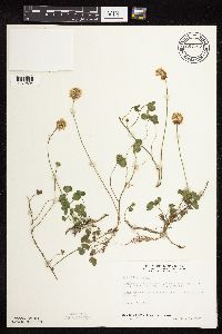 687187[1079504]Wheeler, Gerald; Glaser, Paul 16151977-07-05 United States, Minnesota, Itasca, Site 47. SW14 SW14 Sec. 36, T57N, R27W; ca. 12.5 mi. NW of Grand Rapids.;;;;, 47.3785881 -93.719761 |
MIN:Plants | 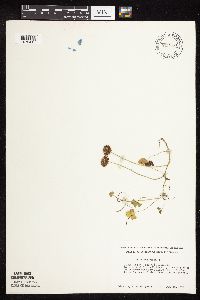 712169[1079415]Smith, Welby 19131979-06-18 United States, Minnesota, Wright, 0.2 mi N of co. hwy 75, 5.5 mi NW of its jnc with st. hwy 25 in Monticello; T122N R25W SE1/4 NW1/4 Sec. 30;;122N;25W;30, 45.3459891 -93.8840265 |
MIN:Plants | 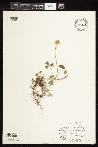 717480[1079395]Mathisen, Ron 761979-06-22 United States, Minnesota, Hubbard, Spearhead Lake [Preserve];Spearhead Lake Preserve (Audubon);145N;34W;, 47.372044 -94.95883 |
MIN:Plants | 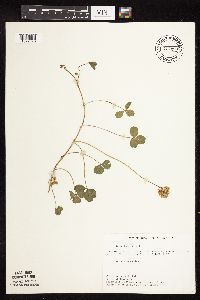 717593[1079396]Farrell, P. 4571979-06-25 United States, Minnesota, Norman, Frenchman's Bluff, 2.5 mi N of Flom; Sec. 18 T143N R43W;Frenchmans Bluff Scientific Natural Area;143N;43W;18, 47.2019677 -96.1838932 |
MIN:Plants | 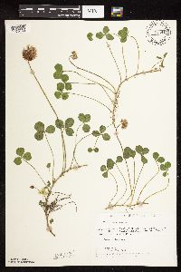 721341[1079480]Lustig, K. 4541979-06-13 United States, Minnesota, Sherburne, Clear Lake - Mississippi Scenic and Recreational River, SNA: 12 mi. SE of St. Cloud, Sec. 14, 22, 23, T34N, R30W.;Clear Lake Scientific Natural Area;034N;30W;, 45.4362154 -94.0372393 |
MIN:Plants | 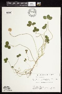 722716[1079419]Lustig, K. 7641979-07-18 United States, Minnesota, Anoka, Anoka County...Boot Lake SNA, 18 mi SE of Cambridge; Sec. 17, 18, 19, 20 T33N R22W;Boot Lake Scientific Natural Area;033N;22W;00, 45.34066 -93.08146 |
MIN:Plants | 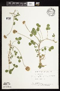 722814[1079420]Lustig, K. 4871979-06-14 United States, Minnesota, Anoka, Anoka County...Boot Lake SNA, 18 mi SE of Cambridge; Sec. 17, 18, 19, 20 T33N R22W;Boot Lake Scientific Natural Area;033N;22W;00, 45.34066 -93.08146 |
MIN:Plants | 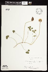 727404[1079424]Ottoson, S. 841979-07-18 United States, Minnesota, Clay, Clay County Bicentennial Prairie, 4 mi SE of Felton; SW1/4 Sec. 5 T141N R45W;Felton Prairie-Bicentennial Prairie Scientific Natural Area;141N;45W;5, 47.0567136 -96.4173556 |
MIN:Plants | 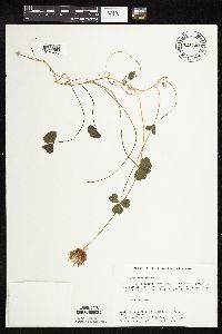 727440[1079423]Severson, M.; Farrell, P. 1721979-07-24 United States, Minnesota, Polk, 6.5 mi E of Harold;Pembina Trail Preserve Scientific Natural Area;;;, 47.690091 -96.355014 |
MIN:Plants | 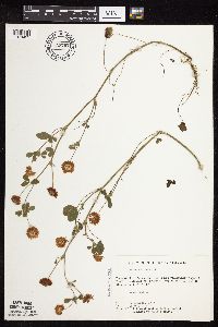 727767[1079435]Severson, M. 1001979-07-25 United States, Minnesota, Polk, Pankratz Prairie South, 7 mi SE of Crookston; SE1/4 Sec. 17, NE1/4 Sec. 20 T149N R45W;Pankratz Memorial Prairie, The Nature Conservancy;149N;45W;, 47.7094164 -96.4489856 |
MIN:Plants | 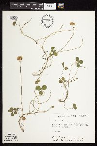 729184[1079422]Berlin, N. 901979-06-27 United States, Minnesota, Goodhue, Wacouta Pond Natural Area, 5 mi SE of Red Wing;Wacouta Pond Natural Area, The Nature Conservancy;;;, 44.5351457 -92.4198697 |
MIN:Plants | 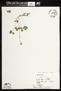 729984[1079421]Converse, C. 3021980-06-16 United States, Minnesota, Pine, Pine Co. Kettle River Natural Area, 5.5 mi E of Hinckley; NW1/4 SW1/4 Sec. 23 T41N R20W;Kettle River Scientific Natural Area / Sandstone National Wildlife Refuge;041N;20W;23, 46.01861 -92.8358 |
MIN:Plants | 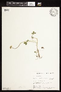 734878[1079496]Cross-Cella, J. 601980-06-05 United States, Minnesota, Becker, Green Water Lake Natural Area: 5 mi. W of Ponsford. SE1/4 Sec. 34, T141N, R38W.;Greenwater Lake Scientific Natural Area / White Earth Indian Reservation;141N;38W;34, 46.9840759 -95.4765612 |
MIN:Plants | 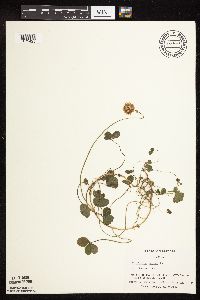 738376[1079425]Galatowitsch, S. 2861982-06-22 United States, Minnesota, Rice, Rice Co. Trout Lily Preserve; T110N R20W;Cannon River Trout Lily Scientific Natural Area;110N;20W;, 44.381274 -93.211815 |
MIN:Plants | 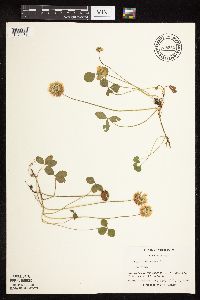 738519[1079483]Galatowitsch, S. 3671982-07-01 United States, Minnesota, Wabasha, Wabasha County...Weaver Dunes; T109N R9W SE1/4 and E1/2 NE1/4 of Sec. 7; NW1/4 and W1/2 NE1/4 of Sec. 8;Kellogg-Weaver Dunes Scientific Natural Area / Kellogg-Weaver Dunes, The Nature Conservancy;109N;09W;00, 44.2581065 -91.9389097 |
MIN:Plants | 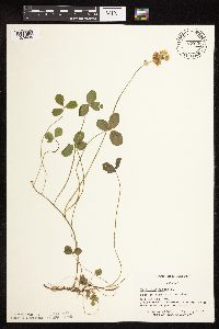 739748[1079485]Converse, C. 15831982-07-12 United States, Minnesota, Pope, Ordway Prairie: T123N, R36W, SE1/4 NE1/4 Sec. 30.;Ordway Prairie, The Nature Conservancy;123N;36W;30, 45.4342616 -95.2450181 |
MIN:Plants | 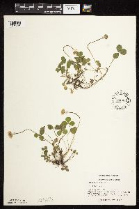 741302[1079446]Converse, C. 10911982-06-11 United States, Minnesota, Chippewa, Chippewa and Swift Cos.; SE1/4 SW1/4 Sec.12. Chippewa Prairie: T119N R43W;Chippewa Prairie, The Nature Conservancy;119N;43W;12, 45.1302134 -95.9905655 |
MIN:Plants | 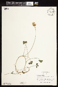 741411[1079490]Converse, C. 16921982-07-20 United States, Minnesota, Otter Tail, Otter Tail Preserve: T131N, R44W, E1/2 Sec. 17.;Ottertail Prairie Scientific Natural Area;131N;44W;17, 46.1592444 -96.2353633 |
MIN:Plants | 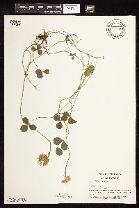 741550[1079486]Converse, C. 13761982-06-30 United States, Minnesota, Pope, Moe Woods: T123N, R36W, SW1/4 SW1/4 Sec. 34;Moe Woods, The Nature Conservancy;123N;36W;34, 45.4198101 -95.1833376 |
MIN:Plants | 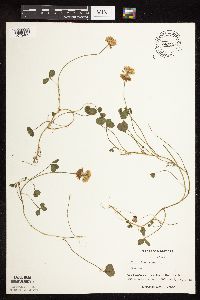 747121[1079482]Galatowitsch, S. 4011982-07-14 United States, Minnesota, Houston, Caledonia Oaks; T102N R5W E1/2 SW1/4 Sec. 24;Caledonia Oaks, The Nature Conservancy;102N;05W;24, 43.6231026 -91.3824233 |
MIN:Plants |  750518[1079489]Almendinger, J. 33101981-08-18 United States, Minnesota, Beltrami, 3 1/2 mi. NE of Wilton, NW of SW Sec. 11, T147N, R34W.;;147N;34W;11, 47.5634272 -94.9598888 |
MIN:Plants |  753103[1079488]Boe, J. 19711983-07-06 United States, Minnesota, Kittson, Norway Dunes: SE1/4 SE1/4 Sec. 10, T160N, R46W.;Norway Dunes, The Nature Conservancy;160N;46W;10, 48.6957357 -96.5727704 |
MIN:Plants |  773122[1079487]Boe, J. 1071979-06-12 United States, Minnesota, Lake of the Woods, Brown's Lake. T159N, R35W, Sec. 11.;Beltrami Island State Forest;159N;35W;11, 48.6052662 -95.1157807 |
MIN:Plants |  773893[1079491]Boe, J. 4421979-06-28 United States, Minnesota, Lake of the Woods, Near jct. of Hwy. 11, near Pitt. NE1/4 of section;;160N;32W;02, 48.7067634 -94.7252901 |
MIN:Plants | 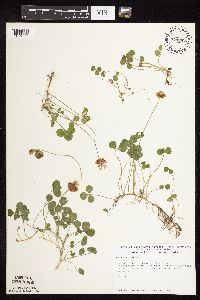 774287[1079502]Monson, Paul 56571983-07-26 United States, Minnesota, Saint Louis, Voyageurs National Park, Kabetogama Narrows Ranger Station, gas depot area; T69N R20W Sec. 25;Voyageurs National Park;069N;20W;25, 48.43325 -92.8423223 |
MIN:Plants | 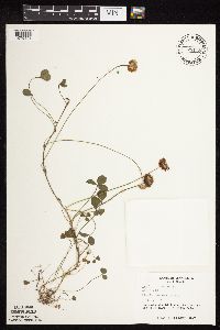 778118[1079448]Duxbury, Alexis 14421983-07-02 United States, Minnesota, Lincoln, Hole-in-the-Mountain Prairie; S1/2 Sec. 19 and SW1/4 Sec. 20 T109N R45W;Hole-in-the-Mountain Prairie, The Nature Conservancy;109N;45W;, 44.2337348 -96.291139 |
MIN:Plants | 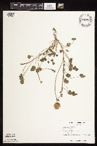 778297[1079447]Duxbury, Alexis 12181983-06-16 United States, Minnesota, Murray, Lundblad Prairie; W1/2 NW1/4 Sec. 1 T105N R41W;Lundblad Prairie Scientific Natural Area;105N;41W;1, 43.9278165 -95.7133858 |
MIN:Plants | 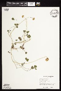 778299[1079449]Duxbury, Alexis 15971983-07-13 United States, Minnesota, Lincoln, Hole-in-the-Mountain Prairie; S1/2 Sec. 19 and SW1/4 Sec. 20 T109N R45W;Hole-in-the-Mountain Prairie, The Nature Conservancy;109N;45W;, 44.2337348 -96.291139 |
MIN:Plants |  778300[1079450]Duxbury, Alexis 12661983-06-19 United States, Minnesota, Nobles, Compass Prairie; SE1/4 SW1/4 Sec. 3 T101N R41W;Compass Prairie Scientific Natural Area;101N;41W;3, 43.5801077 -95.7438528 |
MIN:Plants |  813030[1079385]Wheeler, Gerald 115191988-07-27 United States, Minnesota, Lac Qui Parle, Ca. 6 mi NNE of Bellingham, Lac Qui Parle WMA, S of rock outcrops; N1/2 Sec. 12 T120N R45W (Agassiz Twp.);Lac Qui Parle Wildlife Management Area;120N;45W;12, 45.2146823 -96.2367095 |
MIN:Plants |  813053[1079384]Wheeler, Gerald 115831988-07-28 United States, Minnesota, Big Stone, Ca. 10.5 mi N of Correll, SW of rte 10, between lake and road; NE1/4 Sec. 14 T122N R44W (Artichoke Twp.);;122N;44W;14, 45.3771471 -96.1481275 |
MIN:Plants |  816198[1079501]Bender, J. s.n.1986-06-03 United States, Minnesota, Washington, Belwin Outdoor Education Laboratory; T28N R20W;Belwin Outdoor Education Laboratory;028N;20W;, 44.9271878 -92.7918522 |
MIN:Plants |  825645[1079445]Marion, J. 971982-00-00 United States, Minnesota, Cook, North Shore of Lake Superior, ca. 200 ft. from lakeshore.;North Shore;;;, 47.46396 -91.02551 |
MIN:Plants |  829202[1079515]Myhre, K. 22821992-06-18 United States, Minnesota, Cass, Cass Co. Located 1 mi E of Wabedo Lake; T140N R28W NW1/4 of SW1/4 of Sec 25;;140N;28W;25, 46.9127922 -94.1639891 |
MIN:Plants |  834130[1079433]Smith, Welby 187671991-06-11 United States, Minnesota, Aitkin, Aitkin Co. Hill River State Forest; about 5 mi E of Hill City; T052N R25W SWNE Sec 23.;Hill River State Forest;052N;25W;23, 46.9805565 -93.4805527 |
MIN:Plants |  834297[1079484]Monson, Paul 60201984-08-02 United States, Minnesota, Cook, Grand Portage National Monument. Cook Co. R-5E, T-64N, S-25, Logging road 4 mi NW of visitor center.;Grand Portage National Monument / North Shore;064N;05E;25, 47.9981442 -89.7482849 |
MIN:Plants |  837202[1079513]Smith, Welby 172771990-07-17 United States, Minnesota, Morrison, Camp Ripley Military Reservation. Camp Ripley Military Reservation. Morrison Co. Along East Boundary Road, about 2.5 km N of the airfield. UTM: 394700E 51 Camp Ripley Military Reservation. Morrison Co. Along East Boundary Road, about 2.5 km N of the airfield. UTM: 394700E 510700N T131N R30W SE1/4 of NW1/4 of Sec 32. 131N 30W 32, 46.1145839 -94.4846274 |
MIN:Plants |  510449[1122844]Bright, R. 72-51972-00-00 United States, Idaho, Bannock, [no further data] |
MIN:Plants |  912534[1079095]Smith, Welby 229271993-07-14 United States, Minnesota, Sibley, Sibley County ... Between TH 19 and the adjacent railroad tracks, about 4 miles west of Gaylord ... T112N R29W NE1/4 of NE1/4 of Sec 4. 112N 29W 4, 44.5427778 -94.3116667 |
MIN:Plants |  913613[1079478]Smith, Welby 227261993-07-02 United States, Minnesota, Becker, Becker County...About 2.5 miles east of White Earth...T 142N R 40W NW1/4 of NW1/4 of Sec 29;Two Inlets State Forest / White Earth Indian Reservation;142N;40W;29, 47.0897222 -95.7816667 |
MIN:Plants |  Trifolium wormskioldii Lehmann 236083[1079526]Congdon, J. s.n.1885-06-29 United States, California, Mariposa, Big Tree Grove, Mariposa County;Yosemite National Park;;;, 37.51 -119.60111 |
MIN:Plants |  456496[1079147]Nation, R. 94-1431994-06-21 United States, Minnesota, Mower, Lake Louise State Park. Mower Co.; Tract #22A. T101N R14W NE1/4 of Sec. 21;Lake Louise State Park;101N;14W;21, 43.5365784 -92.5190432 |
MIN:Plants |  477069[1079381]Gerdes, Lynden; et al. 28911998-07-09 United States, Minnesota, Cook, Boundary Waters Canoe Area Wilderness / Superior National Forest. T65N R03E S29SESE. Cook County ... Superior National Forest, BWCAW. Near the NW end of the East Pike Lake and John Lake portage.. 065N 03E 29, 48.086768 -90.089693 |
MIN:Plants |  913506[1079389]Smith, Welby 243261994-06-10 United States, Minnesota, Dakota, Dakota County... Labanon Hills Regional Park in Eagan... T27N R23W NE1/4 of SE1/4 of Sec 32;Lebanon Hills County Park;027N;23W;32, 44.7808333 -93.19 |
MIN:Plants |  505660[1079321]Gerdes, Lynden; et al. 28891998-07-09 United States, Minnesota, Cook, Boundary Waters Canoe Area Wilderness / Superior National Forest. T65N R03E S29SESE.. Cook County ... Superior National Forest, BWCAW. Near the NW end of the East Pike Lake and John Lake portage.. 065N 03E 29, 48.086768 -90.089693 |
MIN:Plants |  432206[1078967]Gerdes, Lynden 38101999-08-13 United States, Minnesota, Cook, Superior National Forest. T65N R04W S26NESE. Cook County...Superior National Forest. Gravel/sand pit approximately .25 mile south east of the Gunflint Trail (Cty.12) and Cross River intersection. Pit is on the south side of the Gunflint Trail.. 065N 04W 26, 48.0844972 -90.8037529 |
MIN:Plants |  456497[1079300]Nation, R. 94-1461994-06-21 United States, Minnesota, Mower, Lake Louise State Park. Mower Co.; Tract #22A. T101N R14W NE1/4 Sec. 21;Lake Louise State Park;101N;14W;21, 43.5365784 -92.5190432 |
MIN:Plants |  429016[1079259]Wheeler, Gerald 171131997-08-11 United States, Minnesota, Chippewa, Chippewa County ... Ca. 2.2 mi. SE of Granite Falls, E of Pete's Pt. Rd. SE ... W1/2 SE1/4 SW1/4 Sec. 12 T115N R39W;Gneiss Outcrops Scientific Natural Area;115N;39W;12, 44.7815206 -95.4926834 |
MIN:Plants |  920664[1079274]Smith, Welby 116191986-06-03 United States, Minnesota, Mower, Brandt-Larson Wildlife Management Area. Mower County...Brandt-Larson State Wildlife Management Area, about four miles northeast of Lyle...along Otter Creek ...NE1/4 SW1/4 section 16, T 101N R 17W. 101N 17W 16, 43.5469444 -92.8813889 |
MIN:Plants | 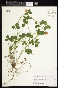 477073[1079150]Gerdes, Lynden; et al. 28901998-07-09 United States, Minnesota, Cook, Boundary Waters Canoe Area Wilderness / Superior National Forest. T65N R03E S29SESE. Cook County ... Superior National Forest, BWCAW. Near the NW end of the East Pike Lake and John Lake portage.. 065N 03E 29, 48.086768 -90.089693 |
MIN:Plants | 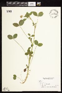 435645[1079172]Nation, R. 94-2401994-07-05 United States, Minnesota, Mower, Lake Louise State Park. Mower Co.; Tract 6. T101N R14W SW1/4 of NE1/4 of Sec. 29;Lake Louise State Park;101N;14W;29, 43.5220732 -92.5388826 |
MIN:Plants | 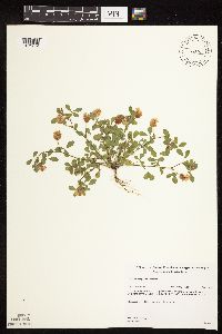 Trifolium campestre Schreber 432192[1079054]Gerdes, Lynden 35501999-07-10 United States, Minnesota, Cook, Superior National Forest. T65N R04W S26. Cook County...Superior National Forest. Old gravel pit/slash burning area; approximately .25 mile north of the Gunflint Trail (Cty. 12) & FR1347 junction; east off FR1347.. 065N 04W 26, 48.0844972 -90.8037529 |
MIN:Plants | 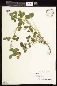 435619[1079120]Nation, R. 94-0781994-06-08 United States, Minnesota, Mower, Lake Louise State Park. Mower Co.; Tract #3A. T101N R14W NW1/4 of SW1/4 of Sec. 21;Lake Louise State Park;101N;14W;21, 43.53658 -92.51904 |
MIN:Plants | 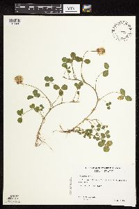 507931[1079439]Wheeler, Gerald 200161999-06-12 United States, Minnesota, Nicollet, Nicollet County ... Ca. 2.5 mi. SW of St. Peter on Rte. 169, W of road ... SW1/4 Sec. 31 T110N R26W;;110N;26W;31, 44.2873683 -93.9920788 |
MIN:Plants | 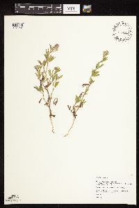 477143[1078964]Hammer, W. s.n.2002-07-08 United States, Minnesota, Ramsey, Arden Hills. Twin Cities Army Ammunition Plant-Arden Hills Army Training Site. Grass management unit 19. E side of NE1/4 NW1/4 of section;;030N;23W;15, 45.0864512 -93.1575501 |
MIN:Plants | 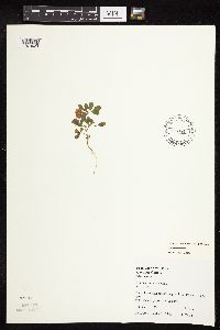 Trifolium campestre Schreber 459595[1079429]Juhnke, C. 389 CMJ FRO1999-06-26 United States, Minnesota, Goodhue, On trail ... along walk-in campsite parking area. SE1/4 SE1/4 NW 1/4of section;Frontenac State Park;112N;13W;02, 44.5350723 -92.3391578 |
MIN:Plants | 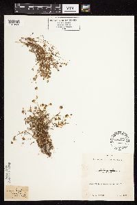 Trifolium variegatum Nuttall 236062[1079525]Congdon, J. s.n.1884-06-00 United States, California, Mariposa, Snow Creek;Yosemite National Park |
MIN:Plants |  461658[1079481]Schik, K. 95-641995-08-17 United States, Minnesota, Polk, Polk Co, T149N R43W NW1/4 of the NE1/4 of S16; Mentor Wildlife Management Area.;Mentor Wildlife Management Area;149N;43W;16, 47.7233128 -96.169862 |
MIN:Plants |  Trifolium campestre Schreber 478266[1079048]Gerdes, Lynden; et al. 30921998-08-06 United States, Minnesota, Cook, Superior National Forest. T65N R04W S26NWSW. Cook County ... Superior National Forest. Roadside; SE of the Gunflint Trail (Hwy. 12) & Cty. 47 (Round Lake road) junction.. 065N 04W 26 |
MIN:Plants |  Trifolium breweri S. Watson 236918[1079029]Congdon, J. s.n.1883-09-16 United States, California, Mariposa, Wawona;Yosemite National Park;;;, 37.53694 -119.65528 |
MIN:Plants |  510260[1079322]Wheeler, Gerald 204021999-08-20 United States, Minnesota, Renville, Renville County ... Ca. 1.8 mi. W of Bird Island on rte. 212; 0.5 mi W of the jct. of Rte 69 and RR tracks ... W1/2 NW1/4 NE1/4 Sec. 16 T115N R34W. 115N 34W 16, 44.7672879 -94.9458201 |
MIN:Plants | 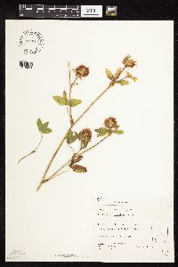 794910[1079201]Schaaf, J. 1841982-08-01 United States, Nevada, Carson City, Carson City Co. ... Kings Canyon, West Eagle Valley, 1494m |
MIN:Plants | 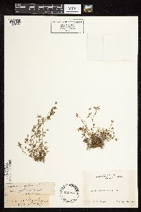 Trifolium variegatum Nuttall 236088[1079522]Congdon, J. s.n.1883-09-16 United States, California, Mariposa, Wawona;Yosemite National Park;;;, 37.53694 -119.65528 |
MIN:Plants | 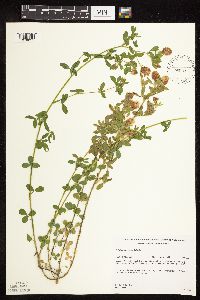 Trifolium campestre Schreber 432198[1079055]Gerdes, Lynden 35541999-07-10 United States, Minnesota, Cook, Superior National Forest. T65N R04W S26. Cook County...Superior National Forest. Old gravel pit/slash burning area; approximately .25 mile north of the Gunflint Trail (Cty. 12) & FR1347 junction; east off FR1347.. 065N 04W 26, 48.0844972 -90.8037529 |
MIN:Plants | 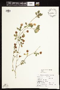 Trifolium campestre Schreber 479271[1079047]DeMink, L. 3841999-09-18 United States, Minnesota, Morrison, Crane Meadows National Wildlife Refuge; NWNE 15-T40N-R31W;Crane Meadows National Wildlife Refuge;040N;31W;15, 45.9628911 -94.1875279 |
MIN:Plants | 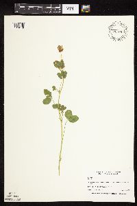 456477[1079148]Nation, R. 94-1801994-06-30 United States, Minnesota, Mower, Lake Louise State Park. Lake Louise State Park. Mower Co.; Tract #1A, south of the Old Minnesota Highway 56 road bed. T101N R14W E1/2 SW1/4 of Sec. 21. 101N 14W 21, 43.5365784 -92.5190432 |
MIN:Plants | 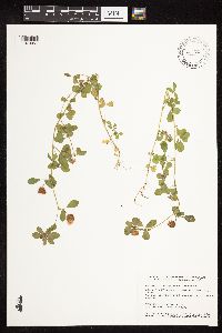 Trifolium campestre Schreber 462248[1079057]Smith, Welby 156581989-07-11 United States, Minnesota, Kanabec, about 9 miles northwest of Mora. SW1/4 SW1/4 of sction;Mille Lacs Wildlife Management Area;040N;25W;16, 45.9511111 -93.4711111 |
MIN:Plants | 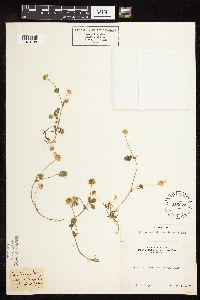 Trifolium microcephalum Pursh 235623[1079198]Congdon, J. s.n.1887-06-06 United States, California, Mariposa, Footman Mt.;Yosemite National Park;;;, 37.54549 -119.82489 |
MIN:Plants | 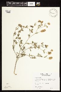 491028[1078966]Wheeler, Gerald 167221997-07-22 United States, Minnesota, Stearns, Stearns County ... Ca. 3.9 mi. S of St. Stephen ... NE1/4 SE1/4 SE1/4 Sec. 12 T125N R29W (St. Wendel 12);;125N;29W;12, 45.6519648 -94.2740664 |
MIN:Plants | 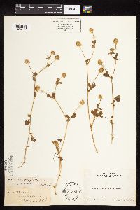 Trifolium microcephalum Pursh 236489[1079199]Congdon, J. s.n.1891-07-22 United States, California, Mariposa, Wawona;Yosemite National Park;;;, 37.53694 -119.65528 |
MIN:Plants | 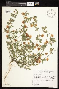 Trifolium campestre Schreber 432190[1079040]Gerdes, Lynden 37021999-08-03 United States, Minnesota, Cook, Superior National Forest. T65N R04W S26SWNE. Cook County...Superior National Forest, Gunflint Trail area. Cross River gravel/sand pit ~ 0.2 mile north of the Gunflint Trail (Cty.12) and FR 1347 junction. Wet, western edge of west pit.. 065N 04W 26, 48.0844972 -90.8037529 |
MIN:Plants | 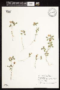 Trifolium campestre Schreber 910943[1079058]Smith, Welby 246351994-07-12 United States, Minnesota, Saint Louis, St. Louis County...About 0.5 mile south of Zim...T 56N R 18W SE1/4 of SE1/4 of Sec 27;;056N;18W;27, 47.3013889 -92.6002778 |
MIN:Plants | 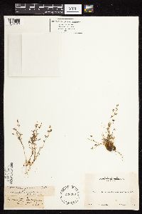 Trifolium variegatum Nuttall 236063[1079523]Congdon, J. s.n.1885-07-03 United States, California, Mariposa, Yosemite Turnpike, Mariposa County;Yosemite National Park;;;, 37.55 -119.9 |
MIN:Plants |  911292[1079388]Smith, Welby 218831992-09-03 United States, Minnesota, Watonwan, Watonwan County...At the public access on the north side of Fedji Lake, about 2 miles northeast of Madelia...T 107N R 30W SW1/4 of SW1/4 of Sec 12. 107N 30W 12, 44.0816667 -94.3880556 |
MIN:Plants |  478289[1078963]Gerdes, Lynden 32581998-09-09 United States, Minnesota, Cook, Superior National Forest. T65N R04W S26NWSW. Cook County ... Superior National Forest. Road edge along the Gunflint Trail (Hwy 12); approx. .25 mile southeast of the Round Lake Road (Cty 47) junction.. 065N 04W 26 |
MIN:Plants |  509300[1079301]Roitsch, C. 4951999-09-18 United States, Minnesota, Morrison, [no further data];Crane Meadows National Wildlife Refuge;;;, 45.9667 -94.3667 |
MIN:Plants |  Trifolium aureum Pollich 432188[1079006]Gerdes, Lynden; et al. 35161999-06-26 United States, Minnesota, Cook, Superior National Forest. T65N R02W S16NE. Cook County...Superior National Forest, North Lake. The eastern shores of the most northern, northeastern oriented peninisula in North Lake, U.S.A.. 065N 02W 16, 48.1076689 -90.1958933 |
MIN:Plants |  910900[1079096]Smith, Welby 244641994-06-21 United States, Minnesota, Isanti, Lyndon Cedarglade County Park. Isanti County...Lyndon Cedarglade Park, about 1.75 miles north of the Anoka-Isanti County line...T 34N R 25W SW1/4 of NE1/4 of Sec 13. 034N 25W 13, 45.4372222 -93.3958333 |
MIN:Plants |  920675[1079345]Smith, Welby 109331985-07-24 United States, Minnesota, Cottonwood, Expandere Wildlife Management Area. Cottonwood County...Expandere State Wildlife Management Area, about 13 miles west-northwest of Windom...SE1/4 SW1/4 section 1, T 105N R 38W. 105N 38W 1, 43.9225 -95.3519444 |
MIN:Plants |  Trifolium breweri S. Watson 236931[1079030]Congdon, J. s.n.1883-06-03 United States, California, Mariposa, Yosemite Turnpike, Mariposa County;Yosemite National Park;;;, 37.55 -119.9 |
MIN:Plants |  915014[1079392]Smith, Welby 226401993-07-01 United States, Minnesota, Otter Tail, Inspiration Peak Scenic Wayside Park. Otter Tail County ... Inspiration Peak State Wayside Park, about 12 miles west of Parkers Prairie ... T131N R39W SE1/4 of SW1/4 of Sec 22. 131N 39W 22, 46.1383333 -95.5736111 |
MIN:Plants |  539934[1079268]Tester, John s.n.1957-06-24 United States, Minnesota, Mahnomen, 3-4 miles W and 1 mile S of Waubun;Waubun Prairie Wildlife Management Area / White Earth Indian Reservation;143N;42W;33, 47.1589 -96.00743 |
MIN:Plants | 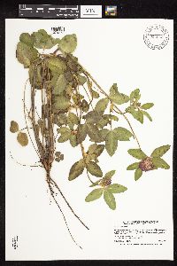 914652[1079273]Smith, Welby 226311993-07-01 United States, Minnesota, Otter Tail, Inspiration Peak Scenic Wayside Park. Otter Tail County ... Inspiration Peak State Wayside Park, about 12 miles west of Parkers Prairie ... T131N R39W SE1/4 of SW1/4 of Sec 22. 131N 39W 22, 46.1383333 -95.5736111 |
MIN:Plants | 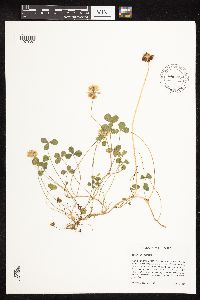 896884[1079387]Haferman, J. 2601996-07-10 United States, Minnesota, Scott, Approximately 0.1 miles north-northeast of intersection of State Highway 13 and County Road 44, north side of highway. SW of SW of section;;115N;22W;36, 44.7245862 -93.4090306 |
MIN:Plants | 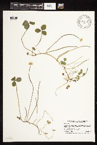 914667[1079391]Smith, Welby 226261993-06-29 United States, Minnesota, Swift, Swift County...Lake Monson State Park, about 17 miles northwest of Wilmar [sic]...T 121N R 37W SW1/4 of NW1/4 of Sec 1;Monson Lake State Park;121N;37W;01, 45.3236111 -95.2688889 |
MIN:Plants | 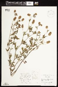 927188[1078970]Fevold, Brick 321994-08-08 United States, Minnesota, Roseau, Hogsback Forest Rd, 1 mi. E of Wildwood Cemetery;Beltrami Island State Forest;159N;34W;, 48.643743 -95.421504 |
MIN:Plants |  923982[1079276]Smith, Welby 216311992-08-26 United States, Minnesota, Nicollet, About 7 miles north of Mankato; bank of Seven Mile Creek. NW1/4 of NE1/4 of section.;Seven Mile Creek County Park;109N;27W;11, 44.2680556 -94.0344444 |
MIN:Plants |  924002[1079275]Smith, Welby 215861992-08-18 United States, Minnesota, Pine, About 1 mile SSW of Willow River (town); adjacent to Willard Munger State Trail. SW1/4 of SE1/4 of section.;;044N;20W;10, 46.3030556 -92.9758333 |
MIN:Plants |  922611[1122824]Smith, Welby 249541994-07-26 United States, Minnesota, Aitkin, Rabbit Lake Wildlife Management Area. Rabbit Lake State Wildlife Management Area; about 2.5 miles northwest of the town of Glen...T 46N R 25W NW1/4 of NW1/4 of Sec 30. 046N 25W 30, 46.4452778 -93.5555556 |
MIN:Plants |  922654[1122828]Smith, Welby 234871993-08-10 United States, Minnesota, Cottonwood, About 6 miles north-northwest of Storden. SW1/4 of NE1/4 of Sec.;;108N;38W;36, 44.1194444 -95.3513889 |
MIN:Plants |  Trifolium campestre Schreber 922626[1122816]Smith, Welby 249621994-07-27 United States, Minnesota, Crow Wing, Crow Wing State Park, about 4 miles southwest of Barrows...T 44N R 32W NW1/4 of SE1/4 of Sec 23;Crow Wing State Park;044N;32W;23, 46.2772222 -94.3391667 |
MIN:Plants |  920166[1122809]Smith, Welby 249851994-07-27 United States, Minnesota, Crow Wing, Crow Wing State Park, about 4 miles southwest of Barrows...T 44N R 32W NW1/4 of SE1/4 of Sec 23;Crow Wing State Park;044N;32W;23, 46.2772222 -94.3391667 |
MIN:Plants |  922213[1122810]Smith, Welby 235821993-08-11 United States, Minnesota, Isanti, About 8 miles northwest of Cambridge. SW1/4 of NW1/4 of section;;037N;24W;26, 45.6658333 -93.3072222 |
MIN:Plants |  921231[1122826]Smith, Welby 257141995-07-03 United States, Minnesota, Scott, Minnesota Valley National Wildlife Refuge. Louisville Swamp Area of the Minnesota Valley National Wildlife Refuge ...T115N R23W SW1/4 of SW1/4 of Sec 28. 115N 23W 28, 44.7355556 -93.5988889 |
MIN:Plants |  928666[1122811]Smith, Welby 158371989-07-20 United States, Minnesota, Mille Lacs, At the public access on the SW end of Shokopee Lake. NW of SE of section;Mille Lacs Kathio State Park;042N;27W;22, 46.1061911 -93.7352976 |
MIN:Plants |  929719[1122817]Smith, Welby 161581989-08-23 United States, Minnesota, Nobles, About 4 miles northwest of Worthington. NW1/4 of NW1/4 of section;Herlein-Boote Wildlife Management Area;102N;40W;07, 43.6588889 -95.6919444 |
MIN:Plants |  930037[1122812]Smith, Welby 159941989-07-31 United States, Minnesota, Kanabec, About 4 miles north of Ogilvie. NW1/4 of SW1/4 of section;Ann Lake Wildlife Management Area;039N;25W;02, 45.8944444 -93.4308333 |
MIN:Plants |  930093[1122813]Smith, Welby 160641989-08-03 United States, Minnesota, Benton, About 5.5 miles SE of Foley. SW1/4 of NW1/4 of section;Bibles Wildlife Management Area;036N;28W;15, 45.6125 -93.8208333 |
MIN:Plants |  933508[1122827]Smith, Welby R. 205211992-06-24 United States, Minnesota, Brown, On the south side of New Ulm in the Cottonwood River Valley NW of SE of section;Flandrau State Park;110N;30W;32, 44.2875 -94.4608333 |
MIN:Plants |  Trifolium wormskioldii Lehmann 143357[1079527]Sheldon, Edmund S 112191902-08-20 United States, Oregon, Clatsop, John Day |
Google Map
Google Maps is a web mapping service provided by Google that features a map that users can pan (by dragging the mouse) and zoom (by using the mouse wheel). Collection points are displayed as colored markers that when clicked on, displays the full information for that collection. When multiple species are queried (separated by semi-colons), different colored markers denote each individual species.