University of Minnesota
http://www.umn.edu/
612-625-5000
http://www.umn.edu/
612-625-5000
Minnesota Biodiversity Atlas
Bell Museum
Dataset: MIN-Plants
Taxa: Typhaceae
Search Criteria: excluding cultivated/captive occurrences
Bell Museum plants | |
 MIN:Plants |  570340[1154584]Morley, T. 9861962-07-01 United States, Minnesota, Hennepin, NE side of Cedar Lake in Minneapolis;;N;;, 44.962599 -93.319969 |
MIN:Plants |  574695[1154534]Moore, John 247751959-07-31 United States, Minnesota, Kittson, 8 1/2 mi. NE of Lancaster.;;N;;, 48.945218 -96.672012 |
MIN:Plants |  582109[1154511]Breckenridge, Walter s.n.1963-07-06 United States, Minnesota, Wilkin, 6 mi NW of Rothsay;;N;;, 46.536348 -96.369809 |
MIN:Plants |  584487[1154558]Ownbey, Gerald 35971963-07-29 United States, Minnesota, Clearwater, 4.5 mi W, 4 mi S of Zerkel, on Height O'Land Truck Trail, E side of Wapatus Lake; T144N R38W NW1/4 Sec. 28;;144N;38W;28, 47.263727 -95.503935 |
MIN:Plants |  590438[1154554]Ownbey, Gerald 37891965-07-30 United States, Minnesota, Hubbard, Twin Lakes; just N of the fill between the lakes, E side. W1/2 of section;Itasca State Park;143N;35W;30, 47.173999 -95.161385 |
MIN:Plants |  607468[1154561]Ownbey, Gerald; Hsi, Yu-tseng [Eugene] 42011968-08-18 United States, Minnesota, Aitkin, McGregor;;;;, 46.606615 -93.313842 |
MIN:Plants |  619257[1154550]Westkaemper, Remberta s.n.1970-07-00 United States, Minnesota, Stearns, Stearns Co. Roscoe. Roadside ditch near Conservancy area.;Roscoe Prairie Scientific Natural Area;123N;29W;17, 45.433611 -94.640278 |
MIN:Plants |  643805[1154513]Olyphant Jr., Murray s.n.1973-08-04 United States, Minnesota, Washington, At the marsh owned by Agassiz Chapter of IWLA: Grant Township; T30N R21W Sec. 6;;030N;21W;6, 45.115974 -92.97518 |
MIN:Plants |  662460[1154492]Ownbey, Gerald; Ownbey, Findley 22691955-07-11 United States, Minnesota, Norman, 10.4 mi W and 1.6 mi S of Mahnomen.;;;;, 47.291864 -96.190707 |
MIN:Plants |  687288[1154531]Wheeler, Gerald; Glaser, Paul 17171977-06-27 United States, Minnesota, Itasca, Itasca Co.; NE1/4 SE1/4 Sec. 26, T145N, R25W; Deer River. Just adjacent to the Deer River Forestry Station.;Leech Lake Indian Reservation;145N;25W;26, 47.34457 -93.797456 |
MIN:Plants |  709711[1154542]Wheeler, Gerald 47201979-08-03 United States, Minnesota, Lac Qui Parle, Salt Lake. Approximately 3.5 mi SW of Marietta; near the shore of the lake.;;117N;46W;05, 44.972372 -96.44368 |
MIN:Plants |  727595[1154562]Herman, J.; Ottoson, S. 1071979-07-17 United States, Minnesota, Norman, 5 mi W of Syre. NW1/4 and E1/2 of SW 1/4 of section;Twin Valley Prairie Scientific Natural Area;143N;45W;23, 47.187129 -96.3544 |
MIN:Plants |  730134[1154545]Converse, C. 3541980-06-23 United States, Minnesota, Chisago, Rush Lake Island Natural Area, 7 mi WSW of Rush City; SE1/4 SW1/4 Sec. 21 T37N R22W;Rush Lake Island Scientific Natural Area;037N;22W;21, 45.673966 -93.094318 |
MIN:Plants |  730621[1154496]Petron, T. 1831980-07-01 United States, Minnesota, Wilkin, Western Prairie South, 6.5 mi NW of Rothsay; NW1/4 SW1/4 Sec. 12 T135N R46W;Western Prairie South Scientific Natural Area;135N;46W;12, 46.536348 -96.369809 |
MIN:Plants |  735857[1154500;1154501]Benson, Douglas 4241981-08-21 United States, Minnesota, Wilkin, Near SE corner of NE1/4 ;Anna Gronseth Prairie, The Nature Conservancy;T134N R45W S08, 46.434833 -96.375181 |
MIN:Plants |  735881[1154537;1154538]Benson, Douglas 3931981-08-18 United States, Minnesota, Wilkin, Town Hall Prairie, drainage ditch along W edge of NW1/4 SW1/4 Sec. 15 T134N R45W;Town Hall Prairie, The Nature Conservancy;134N;45W;15, 46.420333 -96.333183 |
MIN:Plants |  746075[1154572]Smith, Welby 49251981-07-20 United States, Minnesota, Dakota, About 1 mi S of Black Dog Lake, in the Minnesota Valley. NW1/4 NE1/4 of section;Black Dog Preserve Scientific Natural Area;027N;24W;34, 44.788568 -93.276451 |
MIN:Plants |  746134[1154579]Smith, Welby 47981981-07-11 United States, Minnesota, Martin, On the N side of co. hwy 50, ca. 2 1/2 mi W of its jnc with st. hwy 15 in Truman; SW1/4 SE1/4 Sec. 7 T104N R30W;;104N;30W;7, 43.825466 -94.48011 |
MIN:Plants |  749559[1154533]Bonnewell, V.; et al. s.n.1978-07-26 United States, Minnesota, Sherburne, Sherburne County...Sherburne National Wildlife Refuge. T35N, R27W, Sec. 7, SE1/4.;Sherburne National Wildlife Refuge;035N;27W;07, 45.537782 -93.748057 |
MIN:Plants |  749560[1154489]Bonnewell, V.; Glass, A. s.n.1978-08-05 United States, Minnesota, Faribault, SE1/4 of section;Walnut Lake Wildlife Management Area;102N;25W;02, 43.679538 -93.803582 |
MIN:Plants |  749570[1154532]Bonnewell, V.; et al. s.n.1978-08-03 United States, Minnesota, McLeod, McLeod County...Eagle Lake Wildlife Management Area. T115N, R30W, Sec. 4, NW1/4.;Eagle Lake Wildlife Management Area;115N;30W;04, 44.797736 -94.447253 |
MIN:Plants |  753384[1154577]Duxbury, Alexis 18401983-07-23 United States, Minnesota, Murray, Lundblad Prairie; W1/2 NW1/4 Sec. 1 T105N R41W;Lundblad Prairie Scientific Natural Area;105N;41W;1, 43.927817 -95.713386 |
MIN:Plants |  758069[1154502;1154503]Smith, Welby 66001982-07-03 United States, Minnesota, Renville, About 2 mi E of Danube, between U.S. Highway 212 and the Chicago, Milwaukee, St. Paul and Pacific rr tracks. NE1/4 NE1/4 of section;;115N;35W;09, 44.791898 -95.056412 |
MIN:Plants |  758559[1154557]Smith, Welby 73161982-08-19 United States, Minnesota, Nicollet, In the Minnesota Valley. On the E side of U.S. Highway 169, about 2 1/2 mi. SSW of LeSueur. NE1/4 NE1/4 of section;;T111N R26W S16, 44.420539 -93.95977 |
MIN:Plants |  759049[1154527]Smith, Welby 75731982-09-08 United States, Minnesota, Mower, Racine Prairie Scientific Natural Area. Racine Prairie State Scientific and Natural Area, adjacent to the E side of U.S. Trunk hwy 63, ca. 2 mi N of Racine; NE1 Racine Prairie State Scientific and Natural Area, adjacent to the E side of U.S. Trunk hwy 63, ca. 2 mi N of Racine; NE1/4 NE1/4 Sec. 22 T104N R14W. 104N 14W 22, 43.797643 -92.499266 |
MIN:Plants |  759171[1154528_1;1154528_2]Smith, Welby 73031982-08-15 United States, Minnesota, Wright, On the S side of U.S. hwy 12, ca. 1 mi E of Howard Lake; NW1/4 NW1/4 Sec. 2 T118N R27W;;118N;27W;2, 45.063489 -94.050296 |
MIN:Plants |  759219[1154526]Smith, Welby 68991982-07-28 United States, Minnesota, Mower, Racine Prairie Scientific Natural Area. Racine Prairie State Scientific And Natural Area, adjacent to the E side of U.S. Trunk hwy 63, ca. 2 mi N of Racine; NE1 Racine Prairie State Scientific And Natural Area, adjacent to the E side of U.S. Trunk hwy 63, ca. 2 mi N of Racine; NE1/4 NE1/4 Sec. 22 T104N R14W. 104N 14W 22, 43.797643 -92.499266 |
MIN:Plants |  759286[1154525]Smith, Welby 67411982-07-17 United States, Minnesota, Dakota, Dakota Co. Fort Snelling State Park, in the Minnesota Valley 1/2 mi E of Gun Club Lake; SE1/4 NW1/4 Sec. 4 T27N R23W;Fort Snelling State Park;027N;23W;4, 44.856868 -93.180783 |
MIN:Plants |  759352[1154486]Smith, Welby 65011982-06-29 United States, Minnesota, Le Sueur, On the west side of County Highway 23, about 2 miles northeast of St. Peter, in the Minnesota Valley;;110N;26W;11, 44.348192 -93.919173 |
MIN:Plants |  769971[1154580]Smith, Welby 88171983-09-07 United States, Minnesota, Cottonwood, Expandere State Wildlife Management Area, ca. 13 mi WNW of Windom; SE1/4 SW1/4 Sec. 1 T105N R38W;Expandere Wildlife Management Area;105N;38W;1, 43.922133 -95.35356 |
MIN:Plants |  787579[1154553]Smith, Welby 105511985-06-29 United States, Minnesota, Dodge, Dodoge Co. Iron Horse Prairie State Scientific and Natural Area, ca. 1 1/2 mi S of Hayfield; NW1/4 SE1/4 Sec. 27 T105N R;Iron Horse Prairie Scientific Natural Area;105N;17W;27, 43.8675003 -92.8486099 |
MIN:Plants |  801228[1154552]Smith, Welby 119441986-06-28 United States, Minnesota, Anoka, Anoka County...Lamprey Pass State Wildlife Management Area, about 2 mi SW of Forest lake (town)...SW1/4 NE1/4 etc.;Lamprey Pass Wildlife Management Area;032N;22W;13, 45.262643 -93.02753 |
MIN:Plants |  807659[1154508]Dorio, J. 2801977-06-20 United States, Minnesota, Morrison, Morrison Co. Lake Alexander.;;N;;, 46.2 -94.5333 |
MIN:Plants | 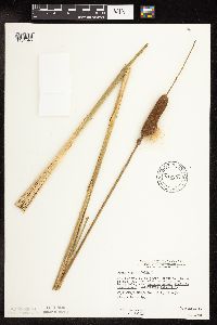 812297[1154546]Wheeler, Gerald 122011988-09-11 United States, Minnesota, Big Stone, Barry Lake Wildlife Management Area. Big Stone Co.; Ca. 1.2 mi NW of Barry, ca. 0.7 mi E of rte 57, margin of Barry Lake; W1/2 SE1/4 NE1/4 Sec. 8 T124N R47W (Tonqua Twp.). 124N 47W 8, 45.567133 -96.579895 |
MIN:Plants | 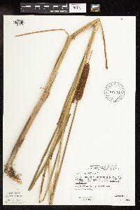 812581[1154576]Wheeler, Gerald 122461988-09-20 United States, Minnesota, Traverse, Ca. 4.5 mi SW of Wheaton, N of rte 27, near Mustinka River (S bank); NW1/4 NE1/4 Sec. 33 T127N R47W (Lake Twp.);;127N;47W;33, 45.780462 -96.565753 |
MIN:Plants | 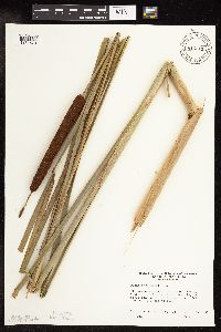 816611[1154578]Ownbey, Gerald 73871990-09-17 United States, Minnesota, Ramsey, Maplewood Nature Center. Ramsey co.; Jim McKee Prairie of Maplewood Nature Center. T 29N, R 22W, Sec 24, at about the center of the section. E en Ramsey co.; Jim McKee Prairie of Maplewood Nature Center. T 29N, R 22W, Sec 24, at about the center of the section. E end of pond.. 029N 22W 24, 44.986499 -92.9922 |
MIN:Plants | 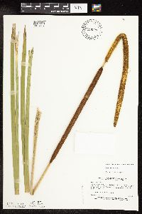 829207[1154487]Myhre, K. 26821992-07-13 United States, Minnesota, Cass, South bank of the Shingobee River. NW1/4 of SW1/4 of section;Chippewa National Forest;141N;31W;15, 47.03013 -94.594706 |
MIN:Plants | 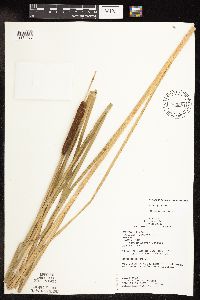 833384[1154485]Juhnke, C. 1741991-07-15 United States, Minnesota, Fillmore, Next to road N of contact station. NW SW SW of section;Forestville State Park;102N;12W;13, 43.637448 -92.219236 |
MIN:Plants | 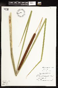 834089[1154555]Smith, Welby 197221991-07-18 United States, Minnesota, Roseau, About 4 mi N of Warroad. Sand bar in Lake of the Woods (Muskeg Bay). NE1/4 of SE1/4 of section;;163N;36W;05, 48.9661102 -95.3161087 |
MIN:Plants | 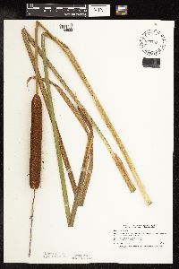 834155[1154522]Smith, Welby 198911991-07-31 United States, Minnesota, Todd, Todd Co. About 2 mi S of Grey Eagle; public access at the NW end of Big Birch Lake. Todd Co. About 2 mi S of Grey Eagle; public access at the NW end of Big Birch Lake; T127N R32W NE1/4 of SE1/4 of Sec 19. 127N 32W 19, 45.7952766 -94.7508316 |
MIN:Plants | 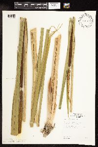 835552[1154495]Monson, Paul 44671960-07-04 United States, Minnesota, Becker, Becker Co, Lake Park Two. 5 mi S of Lake Park;;139N;43W;, 46.813966 -96.0945 |
MIN:Plants |  838315[1154574]Smith, Welby 177821990-08-07 United States, Minnesota, Red Lake, Marcoux Wildlife Management Area. Red Lake Co. In Marcoux Stae Wildlife Management Area, about 5 mi W-SW of Terrebonne; Red Lake Co. In Marcoux Stae Wildlife Management Area, about 5 mi W-SW of Terrebonne; T150N R44W SE1/4 of NE1/4 of Sec 24.. 150N 44W 24, 47.793335 -96.2258301 |
MIN:Plants |  838364[1154575]Smith, Welby 178931990-08-08 United States, Minnesota, Pennington, Pennington Co. At the SE end of the town of St. Hilaire; T152N R43W SE1/4 of SE1/4 of Sec 6;;152N;43W;6, 48.0077782 -96.2050018 |
MIN:Plants |  816586[1154516]Welling, C. CW90-051A1990-07-19 United States, Minnesota, Ramsey, N of Minnesota state highway 96 and 0.6 km E of highway 61;;030N;23W;, 45.094407 -92.998974 |
MIN:Plants |  816591[1154517]Welling, C. CW90-055A1990-07-27 United States, Minnesota, Ramsey, E of Victoria St. and 0.6 km S of County Rd. B. Roseville.;;029N;23W;14, 45.000802 -93.133694 |
MIN:Plants |  461113[1154560]Husveth, J. 96-3071996-09-05 United States, Minnesota, Dakota, 1/4 of the 1/4 of S;;027N;22W;07, 44.84094 -93.096035 |
MIN:Plants |  484725[1154536]Abbott, Robinson s.n.1983-07-04 United States, Minnesota, Pope, Pope County; W. end of Lake Minnawaska, Starbuck.;;125N;39W;, 45.615852 -95.450782 |
MIN:Plants |  906925[1154530]Smith, Welby 311542008-08-19 United States, Minnesota, Beltrami, Big Bog State Park. Beltrami County...Big Bog State Recreation Area, about 9 miles north of Waskish on Highway 72...old gravel pit... T 156N R 31W NE1/4 of SW1/4 of Sec 36. 156N 31W 36, 48.2844444 -94.5683333 |
MIN:Plants |  454924[1154529]Smith, Welby 206911992-07-08 United States, Minnesota, Goodhue, Goodhue County ... About 3 miles west of Red Wing ... in the Cannon River Valley ... T113N R15W SW1/4 of SE1/4 of Sec 21;Dorer Memorial Hardwood State Forest;113N;15W;21, 44.5738907 -92.6194458 |
MIN:Plants |  428156[1154535]Husveth, J. 96-0881996-06-19 United States, Minnesota, Wright, Wright Co. T119N R25W SE1/4 of the NE1/4 of S2;;T119N R25W S2, 45.144089 -93.796362 |
MIN:Plants |  917044[1154568]Lee, Michael MDL42902006-07-18 United States, Minnesota, Becker, Along State Highway 113 ... 6.5 miles northwest of Two Inlets ... Twin Island Lake. S1/2 of SE1/4 of SE1/4 ;Itasca State Park;142N;36W;06, 47.139422 -95.277979 |
MIN:Plants |  925096[1154505]Cholewa, A. 28372011-08-26 United States, Minnesota, Ramsey, Falcon Heights Community Park, corner of Roselawn and Cleveland avenues. West side of park along west edge of open-water pond.;;029N;23W;16, 44.9969444 -93.1869444 |
MIN:Plants |  924693[1154497]Cholewa, A. 28232011-07-08 United States, Minnesota, Anoka, Linwood Lake, boat launch.;Martin-Island-Linwood Lakes County Park;033N;22W;09, 45.3575 -93.0972222 |
MIN:Plants |  921806[1154566]Smith, Welby 250231994-08-02 United States, Minnesota, Wadena, About 2 miles east of the town of Huntersville. NW1/4 of NW1/4 of section;Huntersville State Forest / Wildlife Management Area;138N;33W;15, 46.7752778 -94.8491667 |
MIN:Plants |  921440[1154512]Smith, Welby 248711994-07-20 United States, Minnesota, Lincoln, On the west side of Lake Benton ... T109N R45W NE1/4 of NE1/4 of Sec 4;;109N;45W;04, 44.2844444 -96.2647222 |
MIN:Plants |  923045[1154564]Smith, Welby 238861993-09-09 United States, Minnesota, Meeker, About 3/4 mile west of Cosmos...right-of-way of the C & NW Railroad (abandoned)...T 117N R 32W SW1/4 of SW1/4 of Sec 16. 117N 32W 16, 44.9369444 -94.7138889 |
MIN:Plants |  921929[1154565]Smith, Welby 257611995-07-18 United States, Minnesota, Pipestone, Split Rock Creek State Park. Split Rock Creek State Park, about 7 miles south-southwest of Pipestone...Split Rock Creek... T 105N R 46W NW1/4 of SW1/4 of Sec 15. 105N 46W 15, 43.8986111 -96.3638889 |
MIN:Plants |  931029[1154582]Smith, Welby R. 158451989-07-20 United States, Minnesota, Mille Lacs, Public access on SW end of Shokopee Lake; about 4 miles NW of Onamia. Sandy Lake. NW1/4 of SE1/4 of section;Mille Lacs Kathio State Park;042N;27W;22, 46.105 -93.7311111 |
MIN:Plants |  935426[1154509]Smith, Welby R. 332102011-08-03 United States, Minnesota, Koochiching, About 26 miles northwest of Big Falls along an unnamed forest road. SW1/4 of SW1/4 of section;Pine Island State Forest;157N;28W;23, 48.3966667 -94.2091667 |
MIN:Plants |  937666[1154510]Gerdes, Lynden B.; Gerdes, D. Lawson 66262012-07-14 United States, Minnesota, Lake, Bald Eagle Lake. Approximately 16.74 miles NW of Isabella, MN and 1.32 miles SW of Pagami Lake.;Boundary Waters Canoe Area Wilderness / Superior National Forest;062N;09W;25, 47.823889 -91.538889 |
MIN:Plants |  447811[1154506]Smith, Welby R. 320712010-08-27 United States, Minnesota, Lake, Forest Hwy 11, about 5 miles northwest of Silver Bay. SE of NE of section;;056N;08W;21, 47.3236809 -91.3485343 |
MIN:Plants |  447769[1154594]Ruby, Janeen 202012-06-25 United States, Minnesota, Jackson, About 10 mi S of Lakefield on State Hwy 86. State property at corner of Cty Hwy 4 and Hwy 86. About 275 m east of parking lot near NW corner of WMA. SW NW of sec;Sangl Wildlife Management Area;101N;36W;21, 43.539001 -95.171042 |
MIN:Plants |  269210[1189757]Fassett, N. C. 5633 United States, Indiana, Lake |
MIN:Plants |  291371[1189758]Muenscher, W. C. 1539 United States, New York, Jefferson |
MIN:Plants |  364662[1189759]Hayden, A. 9327 United States, Iowa, Clay |
MIN:Plants |  266039[1189760]Harris, J. A. C28392 United States, Utah, Millard |
MIN:Plants |  280954[1189761]Harris, J. A. C26102 United States, Utah, Juab |
MIN:Plants |  280958[1189762]Harris, J. A. C29389 United States, Utah, [Iron] |
MIN:Plants |  424425[1189763]Hayden, A. 8739 United States, Iowa, Clay |
MIN:Plants |  56886[1189764]Fisher, G. L. 6 United States, Texas, Harris |
MIN:Plants |  386486[1189765]Senn, H. A. 1942 Canada, Quebec, Gatineau |
MIN:Plants |  424424[1189766]Hayden, A. 8604 United States, Iowa, Clay |
MIN:Plants |  565338[1189767]Grevatt, J. G. 54 Canada, Ontario, Grey |
MIN:Plants |  591350[1189768]Swayne, J. R. 1096 United States, Illinois, Williamson |
MIN:Plants |  56893[1189769]Stevens, G. W. 1610 United States, Oklahoma, Woods |
MIN:Plants |  266471[1189770]Harris, J. A. C28357 United States, Utah, Juab |
MIN:Plants |  603446[1189771]Harrison, D. E. 542 United States, North Carolina, New Hanover |
MIN:Plants | 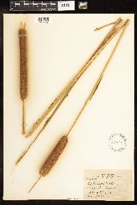 62570[1189772]Harris, J. A. N29272 United States, Nevada, Clark |
MIN:Plants | 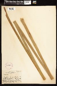 245249[1189773]Harris, J. A. C16133 United States, Florida, Miami-Dade |
MIN:Plants | 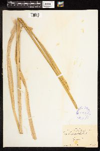 334915[1189774]Harris, J. A. C28722 United States, Utah, Millard |
MIN:Plants | 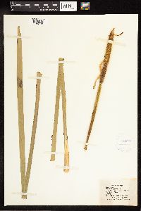 422059[1189775]Horr, W. H. E408 United States, Kansas, Douglas |
MIN:Plants |  418673[1189776]Bossenmaier, E. F. 5 Canada, Manitoba |
MIN:Plants |  56898[1189777]Tyler, A. A. s.n. United States, New York, Richmond |
MIN:Plants |  364792[1189778]Hayden, A. 772 United States, Iowa, Palo Alto |
MIN:Plants |  388243[1189779]Hanes, C. R. s.n. United States, Michigan, Kalamazoo |
MIN:Plants |  62569[1189780]Manning, S. M. s.n. United States, Massachusetts, Norfolk |
MIN:Plants |  58301[1189781]Durand, E. J. s.n. United States, New York, Tompkins |
MIN:Plants |  59738[1189782]Small, J. K. s.n. United States, New York, Richmond |
MIN:Plants |  265121[1189783]Moore, John W. 4611922-07-00 United States, South Dakota, Brookings, 44.311357 -96.798388 |
MIN:Plants |  280956[1189784]Harris, J. A. C29333 United States, Utah |
MIN:Plants |  245248[1189785]Harris, J. A. C16192 United States, Florida, Dade |
MIN:Plants |  245247[1189786]Harris, J. A. C17174 United States, Florida, Collier |
MIN:Plants |  263134[1189787]Harris, J. A. C19260 United States |
MIN:Plants |  505165[1189788]Harris, J. A. C23904 United States, Utah, Juab |
MIN:Plants |  56897[1189789]Umbach, L.M. s.n. United States, Indiana, Porter |
MIN:Plants |  56899[1189790]Steele, E. S. s.n. United States, District of Columbia |
MIN:Plants |  56896[1189791]Umbach, L.M. s.n. United States, Indiana, Porter |
MIN:Plants | 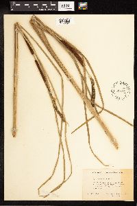 535890[1189792]Radford, A. E. 1180 United States, North Carolina, Carteret |
MIN:Plants | 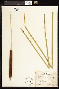 60780[1189793]Bossenmaier, E. F. 206 Canada, Manitoba |
MIN:Plants | 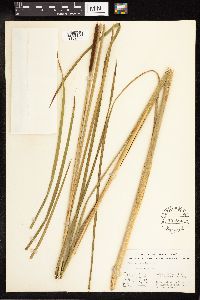 551884[1189794]Stevens, O. A. 1959 United States, North Dakota, Clay |
Google Map
Google Maps is a web mapping service provided by Google that features a map that users can pan (by dragging the mouse) and zoom (by using the mouse wheel). Collection points are displayed as colored markers that when clicked on, displays the full information for that collection. When multiple species are queried (separated by semi-colons), different colored markers denote each individual species.