University of Minnesota
http://www.umn.edu/
612-625-5000
http://www.umn.edu/
612-625-5000
Minnesota Biodiversity Atlas
Bell Museum
Dataset: MIN-Plants
Taxa: Viburnum
Search Criteria: excluding cultivated/captive occurrences
Bell Museum plants | |
 MIN:Plants | 358154[]Stevenson, J. 491912-06-22 United States, Minnesota, Beltrami, Bemidji;;N;;, 47.473563 -94.880277 |
MIN:Plants | 360382[]Lakela, Olga 41011940-08-18 United States, Minnesota, Pine, Pine Co.; at Duquette;;N;;, 46.369667 -92.553251 |
MIN:Plants |  361438[]Lakela, Olga 35831940-06-22 United States, Minnesota, Saint Louis, St. Louis River, about 4 mi S of Gilbert;;N;;, 47.430916 -92.464905 |
MIN:Plants | 363088[]Bergman, H. 29231913-08-03 United States, Minnesota, Itasca, Deer River;;N;;, 47.334197 -93.787874 |
MIN:Plants | 363957[]Gilbert, H. 1871963-06-14 United States, Minnesota, Saint Louis, Duluth;;N;;, 46.783273 -92.106579 |
MIN:Plants | 364689[]Moyle, J. 34941940-06-25 United States, Minnesota, Lake, Along banks of Knife R.;;N;;, 47.042702 -91.793434 |
MIN:Plants | 366954[]Moore, John; Butters, F. 134641940-09-03 United States, Minnesota, Carlton, Valley of little stream, 3 mi S of Black Hoof;;047N;17W;, 46.5479145 -92.4889708 |
MIN:Plants | 369238[]Lakela, Olga 43811941-06-21 United States, Minnesota, Saint Louis, Stony Point; on Lake Superior;North Shore;051N;12W;02, 46.932236 -91.8253612 |
MIN:Plants | 370302[]Moore, John; et al. 144961941-06-15 United States, Minnesota, Pennington, Beside Hwy. 59; 1 mi. SE of Thief River Falls. Pennington Co.;;;;, 48.099144 -96.149989 |
MIN:Plants | 370320[]Moore, John; et al. 144791941-06-15 United States, Minnesota, Marshall, Thief River, SW1/4 Sec.7 Agder Twp. Marshall Co.;;155N;42W;07, 48.2579206 -96.0989322 |
MIN:Plants | 371971[]Moore, John; et al. 147831941-07-07 United States, Minnesota, Becker, Becker County...SE shore of Cotton Lake, Erie Twp.;;139N;40W;12, 46.8684858 -95.6779656 |
MIN:Plants | 375160[]Lakela, Olga 49411942-06-07 United States, Minnesota, Carlton, near Holyoke;;N;;, 46.467443 -92.388528 |
MIN:Plants | 381424[]Moore, John; et al. 156901942-09-24 United States, Minnesota, Olmsted, Pleasant Grove Twp, Sec.20, Olmsted Co.;Dorer Memorial Hardwood State Forest;105N;13W;20, 43.8842917 -92.4083713 |
MIN:Plants | 392823[]Lakela, Olga 70021947-07-29 United States, Minnesota, Saint Louis, St. Louis River bank on Moose line Rd. White T.;;058N;15W;, 47.5018815 -92.2403542 |
MIN:Plants | 393054[]Lakela, Olga 73721947-09-11 United States, Minnesota, Saint Louis, Hellwig Creek on hwy 53.;;052N;17W;, 46.9822835 -92.49158 |
MIN:Plants | 393951[]Butters, F.; Abbe, E.; Burns, G. 7121940-07-03 United States, Minnesota, Cook, Head of lower portage on the Royal River. T64N, R3E. Cook Co.;Superior National Forest;064N;03E;, 48.0187918 -90.0555267 |
MIN:Plants | 407588[]Lakela, Olga 81781949-06-04 United States, Minnesota, Saint Louis, Terrace of Prairie Lake. SW St. Louis Co.;;050N;20W;, 46.809279 -92.8706753 |
MIN:Plants | 412228[]Moore, John; Moore, Marjorie 110631939-07-21 United States, Minnesota, Lake of the Woods, W side of Pine Creek, Angle Inlet, 1/2 mi. from the mouth of creek.;Northwest Angle;168N;34W;, 49.3446208 -95.0288931 |
MIN:Plants | 412559[]Moore, John; Moore, Marjorie 120841939-08-23 United States, Minnesota, Koochiching, Koochiching County ... 4 mi. east of Birchdale;;;;, 48.626872 -94.014268 |
MIN:Plants | 419804[]Lakela, Olga 104111950-06-17 United States, Minnesota, Saint Louis, Sucker River, at Pioneer Rd. bridge;;N;;, 46.968428 -92.203258 |
MIN:Plants | 419939[]Lakela, Olga 105291950-06-24 United States, Minnesota, Saint Louis, St. Louis River woods, near the bridge at hwy #4, S of Biwabik;;N;;, 47.532981 -92.340179 |
MIN:Plants | 420000[]Lakela, Olga 105521950-06-24 United States, Minnesota, Saint Louis, N of Floodwood on hwy 73;;N;;, 46.92911 -92.919648 |
MIN:Plants | 420015[]Lakela, Olga 111791950-08-08 United States, Minnesota, Saint Louis, Savanna River, W of Floodwood, hwy 29;Savanna State Forest;N;;, 46.92911 -92.919648 |
MIN:Plants | 420941[]Lakela, Olga 119211950-09-01 United States, Minnesota, Saint Louis, Floodwood River, hwy 73, about 10 mi N of Floodwood.;;N;;, 47.073873 -92.919648 |
MIN:Plants | 421136[]Lakela, Olga 108191950-07-24 United States, Minnesota, Saint Louis, Pequaywan Lake Rd, S of Rollins;;N;;, 47.154469 -91.910925 |
MIN:Plants | 422629[]Lakela, Olga 78341948-09-18 United States, Minnesota, Carlton, Nemadji River, S of Fond du Lac;;N;;, 46.500421 -92.457456 |
MIN:Plants | 424095[]Emanuel, J. 461946-07-05 United States, Minnesota, Itasca, County: Itasca. Locality: Nashwauk Township;;057N;22W;00, 47.40917 -93.195 |
MIN:Plants | 437230[]Moore, John; Moore, Marjorie 121601939-08-27 United States, Minnesota, Lake of the Woods, at Rocky Point, Lake of the Woods;;163N;34W;, 48.9305062 -95.0257583 |
MIN:Plants | 438533[]Moore, John; et al. 198201947-09-25 United States, Minnesota, Rice, Nerstrand Woods State Park;Nerstrand Woods State Park;110N;19W;09, 44.34887 -93.11108 |
MIN:Plants | 439664[]Kukachka, B. 3161937-06-06 United States, Minnesota, Ramsey, Battle Creek Park;Battle Creek County Park;028N;22W;, 44.93606 -93.013698 |
MIN:Plants | 441989[]Moore, John; et al. 182131945-09-05 United States, Minnesota, Lake of the Woods, Lake of the Woods County...Growing on Rocky Point on Lake of the Woods.;;163N;34W;, 48.9305062 -95.0257583 |
MIN:Plants | 442305[]Lakela, Olga 137851951-09-14 United States, Minnesota, Saint Louis, Shorewoods of Crane Lake, the Congdon Resort;Superior National Forest;N;;, 48.266572 -92.488491 |
MIN:Plants | 442687[]Lakela, Olga 126371951-06-24 United States, Minnesota, Saint Louis, Bear Island River bank at hwy #1 SE of Ely;;062N;12W;23, 47.8386999 -91.8318253 |
MIN:Plants | 444539[]Sather, Nancy s.n.1995-08-18 United States, Minnesota, Mahnomen, Mahnomen Co.; east of Jessie Lake; T143 R40 NE of Sec 27;White Earth Indian Reservation / White Earth State Forest;143N;40W;27, 47.1723024 -95.7317048 |
MIN:Plants | 444822[]Moore, John; Huff, N. 195771947-06-14 United States, Minnesota, Itasca, 12 mi. S of Grand Rapids;;N;;, 47.063459 -93.530214 |
MIN:Plants | 446167[]Moore, John; et al. 173261945-06-20 United States, Minnesota, Red Lake, Red Lake County...2 1/2 mi SW of Red Lake Falls;;;;, 47.856597 -96.312366 |
MIN:Plants | 446215[]Moore, John; Huff, N. 191921946-08-31 United States, Minnesota, Morrison, 1 mi. S of the Snow School House, Parker Twp.;;N;;, 46.07517 -94.534862 |
MIN:Plants | 446531[]Moore, John; Huff, N. 185761946-06-11 United States, Minnesota, Itasca, 1 mi SE of Big Fork;Chippewa National Forest;N;;, 47.759244 -93.893186 |
MIN:Plants | 455810[]Dunevitz, H. 8081990-10-24 United States, Minnesota, Goodhue, Goodhue Co.; Lake Pepin, in Hok-Si-La park; T 112N R 12W SW1/4 of SW1/4 of Sec 29;;112N;12W;29, 44.4738021 -92.2829935 |
MIN:Plants | 455951[]Myhre, K. 52771994-08-22 United States, Minnesota, Itasca, Itasca Co.; located one half mile northeast of Batson Lake; Rice River; T 60N R 26W NW1/4 of SE1/4 of Sec 26;Chippewa National Forest;060N;26W;26, 47.6531037 -93.609286 |
MIN:Plants | 456285[]Zager, S. 930712-71993-07-12 United States, Minnesota, Houston, Houston Co.; MCBS# 131; SW1/4 SW1/4 NW1/4 Sec 27 T102N R05W;Dorer Memorial Hardwood State Forest;102N;05W;27, 43.6088533 -91.4220772 |
MIN:Plants | 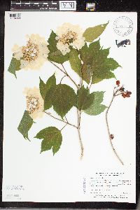 459148[1334368]Myhre, K. 49611994-06-12 United States, Minnesota, Itasca, Itasca Co.; located directly SW of Spring Lake; T148N R25W SW1/4 of SE1/4 of Sec 8;Chippewa National Forest;148N;25W;8, 47.6496802 -93.8686938 |
MIN:Plants | 459169[]Smith, Welby 130141987-06-18 United States, Minnesota, Pine, Pine Co.; in the St. Croix River Valley, about 7 miles SE of Pine City; about 70 feet above the floodplain; SW1/4 NE1/4 Pine Co.; in the St. Croix River Valley, about 7 miles SE of Pine City; about 70 feet above the floodplain; SW1/4 NE1/4 sec.21, T38N R20W. 038N 20W 21, 45.7666664 -92.8475037 |
MIN:Plants | 491716[]Lakela, Olga 168741953-08-25 United States, Minnesota, Saint Louis, White Face River terrace, S of Meadowlands;;N;;, 47.071884 -92.732416 |
MIN:Plants | 508482[]Lee, Michael; et al. MDL9091995-05-19 United States, Minnesota, Fillmore, Fillmore Co.; N-facing slope along the South Branch Root River 2 mi NE of Cherry Grove; T102N R12W NENW 27;;102N;12W;27, 43.6090427 -92.2587654 |
MIN:Plants | 508621[]Lee, Michael; et al. MDL8931995-05-17 United States, Minnesota, Fillmore, Forestville State Park. Fillmore Co. Forestville State Park; N-facing slope in tributary ravine of Canfield Creek 1 1/2 mi S of the Forestville Fillmore Co. Forestville State Park; N-facing slope in tributary ravine of Canfield Creek 1 1/2 mi S of the Forestville townsite; T102N R12W SWSWNE 25. 102N 12W 25, 43.60901 -92.21913 |
MIN:Plants | 514401[]Smith, Welby 193701991-07-10 United States, Minnesota, Koochiching, Grand Mound Historical Site. Koochiching County...Grand Mound Historic Site, about 18 miles W of International Falls; floodplain of the Rainy River...T70N R26W NW1/4 of NE1/4 of Sec 32. 070N 26W 32, 48.5158333 -93.7083333 |
MIN:Plants | 515803[]Scott, P. 7721994-07-06 United States, Minnesota, Cook, Cook Co.; by North Brule River approx. 1/2 mile W of road 1378, Superior N.F. T64N R1W sec.23.;Superior National Forest;064N;01W;23, 48.0118477 -90.4157931 |
MIN:Plants | 520232[]Smith, Welby 129561987-06-16 United States, Minnesota, Washington, Washington County...On the E side of Highway 4, about 1/2 mi NW of Marine on St. Croix...about 150 feet above the floodplain of the St. Croix River...SW1/4 NE1/4 sec.1, T31N R20W. 031N 20W 1, 45.2061111 -92.7797222 |
MIN:Plants | 525897[]Lakela, Olga 186651955-06-04 United States, Minnesota, Saint Louis, Sturgeon River Valley at the hwy bridge, #73;;N;;, 47.77659 -92.868791 |
MIN:Plants | 527122[]Lakela, Olga 174771954-06-16 United States, Minnesota, Saint Louis, Ash River bank; 3 mi N of Ash Lake, hwy 53;;N;;, 48.262224 -92.915998 |
MIN:Plants | 532307[]Lakela, Olga 199631956-06-22 United States, Minnesota, Saint Louis, In a glen off the Little Swan River, Hwy. 5, N of Toivola;;N;;, 47.166882 -92.811028 |
MIN:Plants | 532817[]Lakela, Olga 198801956-06-00 United States, Minnesota, Saint Louis, St. Louis River bank, N of Oxbow Rd. W of Zim;;N;;, 47.304665 -92.659034 |
MIN:Plants | 532965[]Lakela, Olga 199351956-06-21 United States, Minnesota, Saint Louis, W of Toimi;;N;;, 47.400477 -91.767669 |
MIN:Plants | 542506[]Lawrence, Donald; et al. 216301952-05-25 United States, Minnesota, Anoka, Anoka County...SE1/4 Sec. 28, Athens Twp. "49 D";Cedar Creek National History Area;034N;23W;28, 45.4066924 -93.2143595 |
MIN:Plants | 543157[]Lakela, Olga 213421957-06-08 United States, Minnesota, Lake, Portage to Pipestone Bay from Back Bay of Basswood Lake;Boundary Waters Canoe Area Wilderness / Superior National Forest;064N;10W;06, 48.0522686 -91.6606513 |
MIN:Plants | 552558[]Partch, M. s.n.1958-08-03 United States, Minnesota, Mahnomen, Mahnomen Co. N of Tulaby Lake;White Earth Indian Reservation / White Earth State Forest;143N;39W;, 47.1942573 -95.614866 |
MIN:Plants | 554302[]Moore, John 231091957-05-28 United States, Minnesota, Clay, Ulen;;N;;, 47.07885 -96.258949 |
MIN:Plants | 558257[]Moore, John 238391958-06-11 United States, Minnesota, Kittson, 1 mi. SW of Lake Bronson;;N;;, 48.7253 -96.678337 |
MIN:Plants | 566418[]Moore, John; Heig, V. 240501958-09-09 United States, Minnesota, Kittson, river at Northcote;;N;;, 48.845261 -97.001169 |
MIN:Plants | 566477[]Moore, John 238941958-06-13 United States, Minnesota, Kittson, 3 mi NW of Lake Bronson;;N;;, 48.766224 -96.709369 |
MIN:Plants | 568645[]Moore, John; Ferguson, A. 249521960-06-07 United States, Minnesota, Blue Earth, Minnesota River bluffs 3 mi W of Mankato;;N;;, 44.160657 -94.067139 |
MIN:Plants | 572671[]Moore, John 257281961-08-09 United States, Minnesota, Anoka, W of the laboratory, Cedar Creek Natural History Area.;Cedar Creek National History Area;034N;23W;, 45.4280632 -93.2039968 |
MIN:Plants | 590122[]Meierotto, R. s.n.1963-07-26 United States, Minnesota, Clearwater, Sec. 12, T143N, R36W.;Itasca State Park;143N;36W;, 47.19557 -95.2332161 |
MIN:Plants | 592473[]Westkaemper, Remberta s.n.1964-06-00 United States, Minnesota, Stearns, Stearns Co. St. Joseph. Meyer's woods.;;124N;29W;, 45.543642 -94.322053 |
MIN:Plants | 616741[]Moore, John; Moore, Marjorie 1631969-06-17 United States, Minnesota, Crow Wing, Crow Wing Natural History Area. SE of Chandler Lake, SW1/4 Sec. 22, Garrison Twp.;Crow Wing Natural Area;144N;28W;22, 46.2789902 -93.8633363 |
MIN:Plants | 628164[]Ownbey, Gerald 46221972-07-28 United States, Minnesota, Clearwater, Clearwater County...Itasca State Park. On Bear Paw Point, E side of Lake Itasca.;Itasca State Park;143N;36W;11, 47.2175215 -95.2014955 |
MIN:Plants | 655169[]Gage Jr., Addison 431900-06-07 United States, Minnesota, Hennepin, Minneapolis;;N;;, 44.98 -93.26361 |
MIN:Plants | 680755[]Clemants, Steven 6701977-05-21 United States, Minnesota, Chisago, Goose Creek. Along line between secs. 14 and 23. T36N R21W. W side of line.;Wild River State Park;036N;21W;, 45.6006319 -92.9603668 |
MIN:Plants | 686924[]Wheeler, Gerald; Glaser, Paul 13501977-05-21 United States, Minnesota, Itasca, Coll. Site #13. NE1/4 SW1/4 Sec.1 T55N R27W; approx. 8 mi NW of Grand Rapids.;;055N;27W;1, 47.2751716 -93.7132977 |
MIN:Plants | 691019[]Sperling, C. 1701976-05-29 United States, Minnesota, Douglas, 1 1/4 mi. S of Spruce Center. On the E side of Spruce Creek.;;N;;, 46.070556 -95.223611 |
MIN:Plants | 698475[]Wheeler, Gerald; Glaser, Paul 32761978-07-16 United States, Minnesota, Beltrami, NW1/4 NE1/4 Sec.10 T156N R32W; approx. 17 mi NW of the Waskish Airport. Western edge of Ovoid Islands Area; about 1 1/4 NW1/4 NE1/4 Sec.10 T156N R32W; approx. 17 mi NW of the Waskish Airport. Western edge of Ovoid Islands Area; about 1 1/4 mi N-NW of Camp No.II.. 156N 32W 10, 48.3464577 -94.7422572 |
MIN:Plants | 698891[]Sather, Nancy; et al. 2501976-07-15 United States, Minnesota, Saint Louis, Along the road at benchmark, unnumbered road W of USFS130. SE1/4 SE1/4 SE1/4 Sec. 18, T57N, R14W.;Superior National Forest;057N;14W;18, 47.4224476 -92.1659529 |
MIN:Plants | 698894[]Sather, Nancy; et al. 3811977-06-14 United States, Minnesota, Lake, Lake Co. NE1/4 SW1/4 Sec. 33, T63N, R11W;Superior National Forest;062N;11W;33, 47.8127561 -91.7364723 |
MIN:Plants | 715567[]Keller, C. 1211979-07-31 United States, Minnesota, Beltrami, Pennington Orchid Bog SNA: 1 mi. N of Pennington, NW1/4 Sec. 3, T146N, R30W.;Leech Lake Indian Reservation / Pennington Bog Scientific Natural Area;146N;30W;3, 47.491615 -94.4690408 |
MIN:Plants | 715638[]Keller, C. 481979-06-28 United States, Minnesota, Beltrami, Pennington Orchid Bog SNA: 1 mi. N of Pennington, NW1/4 Sec. 3, T146N, R30W.;Leech Lake Indian Reservation / Pennington Bog Scientific Natural Area;146N;30W;3, 47.491615 -94.4690408 |
MIN:Plants | 717562[]Grimmelbein, G. 741979-06-23 United States, Minnesota, Hubbard, Spearhead Lake Preserve;Spearhead Lake Preserve (Audubon);145N;34W;, 47.3680989 -94.9909661 |
MIN:Plants | 727642[]Lustig, K. 10951979-09-05 United States, Minnesota, Sherburne, Mississippi River Islands between Monticello and Elk River;Mississippi River Islands Scientific Natural Area;032N;26W;, 45.2773139 -93.5324937 |
MIN:Plants | 729052[]Converse, C. 771980-06-02 United States, Minnesota, Chisago, Goose Creek Natural Area: 5 mi SE of Rush City. NW1/4 SW1/4 sec.6 T36N R20W.;Wild River State Park;036N;20W;6, 45.6366816 -92.8932544 |
MIN:Plants | 729145[]Converse, C. 291980-06-02 United States, Minnesota, Chisago, Goose Creek Natural Area: 5 mi SE of Rush City. NW1/4 NE1/4 Sec.13 T36N R21W.;Wild River State Park;036N;21W;13, 45.6079851 -92.9089182 |
MIN:Plants | 729883[]Converse, C. 2111980-06-09 United States, Minnesota, Pine, Pine Co. Kettle River Natural Area: 5.5 mi E of Hinckley. SW1/4 NW1/4 Sec.23 T41N R20W. Mouth of spring near swamp.;Kettle River Scientific Natural Area / Sandstone National Wildlife Refuge;041N;20W;23, 46.0186087 -92.8357974 |
MIN:Plants | 739317[]Koch, R. 102361976-06-09 United States, Minnesota, Carlton, Ca. 6 mi. E, 1/2 mi. S, 1/2 mi. E Barnum (T45N, R17W, Sec. 6);;045N;17W;6, 46.4107361 -92.5413746 |
MIN:Plants | 739318[]Stackler, S. 17271976-07-02 United States, Minnesota, Carlton, Woods below abandoned farm, ca. 10 mi. E, 1/2 mi. N of Barnum (T46N, R17W, Sec. 35);;046N;17W;35, 46.4250223 -92.4564787 |
MIN:Plants | 744935[]Smith, Welby 41071981-06-06 United States, Minnesota, Wright, At the NE end of a small unnamed lake in Hanover. NW1/4 SE1/4 sec.35 T120N R24W.;;120N;24W;35, 45.1533533 -93.6683201 |
MIN:Plants | 745434[]Smith, Welby 37771981-05-10 United States, Minnesota, Wright, About 1 3/4 mi SE of Silver Creek, and S of co. hwy 39. NW1/4 NW1/4 sec.15 T121N R26W.;;121N;26W;15, 45.2894056 -93.9432038 |
MIN:Plants | 746743[]Englebretson, E. 10381982-05-29 United States, Minnesota, Hennepin, Along southern border near road. Hardscrabble Woods: T117N R24W in Sec.26.;Hardscrabble Woods, The Nature Conservancy;117N;24W;26, 44.9131703 -93.6760053 |
MIN:Plants | 758486[]Smith, Welby 68231982-07-19 United States, Minnesota, Kittson, about 3 mi NE of Halma. W1/2 SE1/4 sec.10 T160N R46W.;;160N;46W;10, 48.6957357 -96.5727704 |
MIN:Plants | 758832[]Smith, Welby 61171982-06-03 United States, Minnesota, Fillmore, Dorer Memorial Hardwood State Forest. Fillmore Co. In the valley of the South Branch Root River, about 2 1/2 mi N of Cherry Grove. N-facing talus slope. SW1/4 Fillmore Co. In the valley of the South Branch Root River, about 2 1/2 mi N of Cherry Grove. N-facing talus slope. SW1/4 NE1/4 sec.21 T102N R12W.. 102N 12W 21, 43.6235548 -92.27871838 |
MIN:Plants | 759020[]Smith, Welby 76241982-10-08 United States, Minnesota, Wright, Harry Larson County Park, about 1/4 mi E of co. rd. 111.;Harry Larson County Forest;122N;26W;35, 45.3332335 -93.9215048 |
MIN:Plants | 762892[]Gilbert, H. 1871923-06-14 United States, Minnesota, Saint Louis, Duluth;;N;;, 46.783273 -92.106579 |
MIN:Plants | 770529[]Smith, Welby 85451983-08-03 United States, Minnesota, Mower, Ca. 3 mi. NE of Lyle. NW1/4 NE1/4 Sec. 29, T101N, R17W.;;101N;17W;29, 43.5215013 -92.8985294 |
MIN:Plants | 773829[]Boe, J. 3061979-06-21 United States, Minnesota, Lake of the Woods, 7 Mile Corner, W of Norris Camp. T159N, R36W, SE1/4 Sec. 18, and NE1/4 Sec. 19.;;159N;36W;, 48.5762814 -95.3316242 |
MIN:Plants | 773839[]Boe, J. 1701A1979-08-14 United States, Minnesota, Lake of the Woods, Lady Slipper Rest, roadside rest in Williams. NE1/4 of section;<No data>;161N;24W;13, 48.768314 -94.95522 |
MIN:Plants | 773840[]Boe, J. 3371979-06-22 United States, Minnesota, Lake of the Woods, Near Hwy. 1 N of Carp. On a bank of the Baudette River. NW1/4 Sec. 4, R31W, T1569N.;;159N;31W;4, 48.6205515 -94.6372407 |
MIN:Plants | 773842[]Boe, J. 4451979-06-28 United States, Minnesota, Lake of the Woods, S of Roosevelt. Near powerline clearing. W1/2 Sec. 18, R34W, T161N.;;161N;34W;18, 48.7638026 -95.0792643 |
MIN:Plants | 774161[]Monson, Paul 53761984-06-16 United States, Minnesota, Saint Louis, Voyageur's National Park. R-21W T-70N S-34. Kabetogama peninsula, E of Camel Back Is.;Voyageurs National Park;070N;21W;34, 48.5071336 -93.0152068 |
MIN:Plants | 774237[]Monson, Paul 54841983-06-20 United States, Minnesota, Saint Louis, Voyageur's National Park. R-21W T-69N S-19. Kabetogama Rd, 4 mi N of hwy 53. W side of road.;Voyageurs National Park;069N;21W;19, 48.4505163 -93.0809868 |
MIN:Plants | 781707[]Smith, Welby 89841984-06-11 United States, Minnesota, Morrison, Pellager Peatland, ca. 4 mi. SW of Pellager. NW1/4 NW1/4 Sec. 36, T133N, R31W.;;133N;31W;36, 46.2896628 -94.5274558 |
MIN:Plants | 782646[]Bolin, Kathy KEB51982-05-18 United States, Minnesota, Fillmore, Forestville State Park. Fillmore Co. T102N R12W Sec.24 NE1/4 SW1/4 NE1/4. S of pines, E of river, steep W facing slope.;Forestville State Park;102N;12W;24, 43.6234111 -92.2191515 |
MIN:Plants | 795639[]Wheeler, Gerald 63451982-08-11 United States, Minnesota, Mahnomen, Mahnomen Co. Approx. 1.5 mi N of the jct. of Rt. 113 and Rt. 4 (W side of Rte. 4). T143N, R39W, Sec. 19.;White Earth Indian Reservation / White Earth State Forest;143N;39W;19, 47.1869818 -95.6681393 |
Google Map
Google Maps is a web mapping service provided by Google that features a map that users can pan (by dragging the mouse) and zoom (by using the mouse wheel). Collection points are displayed as colored markers that when clicked on, displays the full information for that collection. When multiple species are queried (separated by semi-colons), different colored markers denote each individual species.