University of Minnesota
http://www.umn.edu/
612-625-5000
http://www.umn.edu/
612-625-5000
Minnesota Biodiversity Atlas
Bell Museum
Dataset: MIN-Plants
Taxa: Alyssum
Search Criteria: excluding cultivated/captive occurrences
1
Page 1, records 1-12 of 12
Bell Museum plants | |
 MIN:Plants | Alyssum alyssoides (L.) L. 116949[]Manning, Sara s.n.1883-05-06 United States, Minnesota, Wabasha, Lake City;;111N;12;04, 44.447017 -92.258983 |
MIN:Plants | Alyssum alyssoides (L.) L. 116950[]Herrick, C. s.n.1878-05-00 United States, Minnesota, Minneapolis;;029N;24W;00, 44.9919261 -93.2881533 |
MIN:Plants | Alyssum alyssoides (L.) L. 277785[]Roberts, Thomas s.n.1878-04-27 United States, Minnesota, Hennepin, Minneapolis;;029N;24W;25, 44.969959 -93.237021 |
MIN:Plants | Alyssum alyssoides (L.) L. 282496[]Lakela, Olga 5531933-05-01 United States, Minnesota, Hennepin, Long Meadow Gun Club;;;;, 44.84092 -93.22878 |
MIN:Plants | 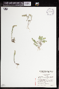 Alyssum desertorum Stapf 923907[1352087]Cholewa, A. 27882011-05-12 United States, Minnesota, Freeborn, White Fox Campground.;Myre Big Island State Park;102N;21W;13, 43.6338889 -93.3 |
MIN:Plants | Alyssum alyssoides (L.) L. 116948[]Kassube, J. s.n.1878-05-00 United States, Minnesota, Ramsey, Agricultural College [Univ. of Minn. St. Paul campus];;029n;23W;, 44.992077 -93.166387 |
MIN:Plants | Alyssum alyssoides (L.) L. 931753[]Smith, Welby R. 203751992-06-09 United States, Minnesota, Roseau, About 100 meters south of the international border (Manitoba-Minnesota) NE of SE of section;;164N;40W;30, 48.9994444 -95.8580556 |
MIN:Plants | Alyssum desertorum Stapf 944931[]Dziuk, Peter M. PMD15-0192015-05-06 United States, Minnesota, Saint Louis, Indian Point Campground. Camp site #44., 46.721547 -92.182903 |
MIN:Plants | 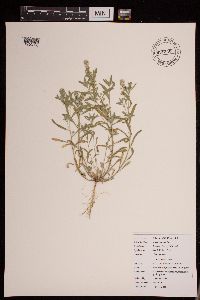 Alyssum alyssoides (L.) L. 951340[1290226]Dziuk, Peter M. PMD16-0152016-04-20 United States, Minnesota, Marshall, Old Mill State Park. Campground. T156N R46W sec 4, 48.365081 -96.568956 |
MIN:Plants | 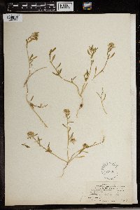 117008[1369661]Cook, Alice Carter 5921897-02-00 Spain, Gran Canaria |
MIN:Plants | 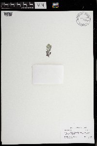 Alyssum alyssoides (L.) L. 0971207[1394680]Bolduan, Brad 2142021-05-22 United States, Minnesota, Yellow Medicine, Mound Spring Prairie Scientific and Natural Area, 44.7407 -96.4258 |
MIN:Plants | Alyssum parviflorum Fisch. ex M. Bieb. []Tripp, J. GW24882005-06-29 United States, Colorado, Delta, Private property, along Rotcap Creek, Pitkin Mesa, 38.870528 -107.638472, 1808m |
1
Page 1, records 1-12 of 12
Google Map
Google Maps is a web mapping service provided by Google that features a map that users can pan (by dragging the mouse) and zoom (by using the mouse wheel). Collection points are displayed as colored markers that when clicked on, displays the full information for that collection. When multiple species are queried (separated by semi-colons), different colored markers denote each individual species.