University of Minnesota
http://www.umn.edu/
612-625-5000
http://www.umn.edu/
612-625-5000
Minnesota Biodiversity Atlas
Bell Museum
Dataset: MIN-Plants
Taxa: Antiaris
Search Criteria: excluding cultivated/captive occurrences
1
Page 1, records 1-11 of 11
Bell Museum plants | |
 MIN:Plants | 903458[] GW27452006-10-30 Australia, Queensland, CSIRO Atheron Arboretum tree #44 ex Hyland 2927 (Pin Pin, Cape York Peninsula, Australia), -13.2 143.25 |
MIN:Plants | Antiaris toxicaria Lesch. 431542[]Weiblen, G.D. GW11152000-05-21 Papua New Guinea, Madang, Kau Wildlife Area, Baitabag village nr. Madang, -5.133333 145.766667, 50m |
MIN:Plants |  Antiaris toxicaria subsp. macrophylla (R. Br.) C.C. Berg 892252[]Isua, Brus GW26902005-11-03 Papua New Guinea, Morobe, Lae Botanic Garden, Lae, -6.716667 146.983333, 20m |
MIN:Plants | Antiaris toxicaria Lesch. 903142[] GW27282006-09-24 Papua New Guinea, Madang, Wanang village, Middle Ramu, -5.25 145.266667, 115m |
MIN:Plants |  Antiaris toxicaria Lesch. 903502[]Weiblen, G.D. GW22202004-10-19 Papua New Guinea, East Sepik, Yelwule river, near Wamangu village, -3.787167 143.652, 100m |
MIN:Plants | Antiaris toxicaria Lesch. 903978[]Isua, Brus GW26942005-11-06 Papua New Guinea, East Sepik, near Wamangu village, -3.787167 143.652, 100m |
MIN:Plants | Antiaris toxicaria Lesch. 903979[]Isua, Brus GW26952005-11-06 Papua New Guinea, East Sepik, near Wamangu village, -3.787167 143.652, 100m |
MIN:Plants |  Antiaris toxicaria subsp. macrophylla (R. Br.) C.C. Berg 903986[]Isua, Brus GW26872005-11-06 Papua New Guinea, East Sepik, near Wamangu village, -3.787167 143.652, 100m |
MIN:Plants | 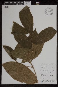 Antiaris toxicaria Lesch. 906437[1297855]Clement, W. WC2262002-09-26 Papua New Guinea, Madang, Wannang village, -5.25 145.266667, 115m |
MIN:Plants | Antiaris toxicaria Lesch. 903165[]G. D. Weiblen GW26902005-11-03 Papua New Guinea, Morobe, Lae Botanic Garden, 6.716667 -146.983333, 20m |
MIN:Plants | Antiaris toxicaria Lesch. 892251[]G. D. Weiblen GW26952005-11-06 Papua New Guinea, East Sepik, near Wamangu village, 3.787167 -143.652, 100m |
1
Page 1, records 1-11 of 11
Google Map
Google Maps is a web mapping service provided by Google that features a map that users can pan (by dragging the mouse) and zoom (by using the mouse wheel). Collection points are displayed as colored markers that when clicked on, displays the full information for that collection. When multiple species are queried (separated by semi-colons), different colored markers denote each individual species.