University of Minnesota
http://www.umn.edu/
612-625-5000
http://www.umn.edu/
612-625-5000
Minnesota Biodiversity Atlas
Bell Museum
Dataset: MIN-Plants
Taxa: Arabidopsis
Search Criteria: excluding cultivated/captive occurrences
Bell Museum plants | |
 MIN:Plants | 505409[]Smith, Welby 274881998-08-04 United States, Minnesota, Cook, Cook County...On the north side of Big Susie Island in Lake Superior...T 64N R 7E SE1/4 of SE1/4 of Sec 32;North Shore / Susie Islands, The Nature Conservancy;064N;07E;32, 47.9783333 -89.5741667 |
MIN:Plants | Arabidopsis lyrata (L.) O 599383[]Tryon, R. 25131936-04-25 United States, Indiana, Porter, Indiana Dunes State Park;Indiana Dunes National Lakeshore;;;, 41.66306 -87.03694 |
MIN:Plants | 225497[]Cooper, William 2501909-08-29 United States, Michigan, Keweenaw, Raspberry Island, Isle Royale;Isle Royale National Park |
MIN:Plants | Arabidopsis lyrata subsp. kamchatica (Fischer ex de Candolle) O’Kane & Al-Shehbaz 548471[]Spetzman, L. 38931951-07-15 United States, Alaska, Arctic North Slope...Canning R. & Ignek Cr.;Arctic National Wildlife Refuge;;;, 69.5833333 -146.25, 305m |
MIN:Plants | 414357[]Russell, N. s.n.1948-05-02 United States, Wisconsin, Saint Croix, Apple River...St. Croix Co. ...lower end of canyon...+/- 2 miles upstream from St. Croix R.;;;;, 45.15639 -92.707613 |
MIN:Plants | Arabidopsis lyrata (L.) O 599729[]Cooper, William 1381929-07-10 United States, Alaska, Glacier Bay, Station 27.;Glacier Bay National Park;;;, 58.797428 -136.838127 |
MIN:Plants | Arabidopsis lyrata subsp. kamchatica (Fischer ex de Candolle) O’Kane & Al-Shehbaz 529990[]Hardy, Robert 1901945-07-12 United States, Alaska, Aleutians...Attu Is. ...Boone Creek, Sidden's Valley;Aleutian Islands Wilderness;;;, 52.9 172.9, 274m |
MIN:Plants | Arabidopsis lyrata subsp. kamchatica (Fischer ex de Candolle) O’Kane & Al-Shehbaz 690121[]Glaser, Paul 7751975-06-18 United States, Alaska, Mt. McKinley National Park...NW1/4Sec.4 T14S R9W, vicinity of Morino Grave;Denali National Park, 549m |
MIN:Plants | 117507[]Steele, E.; et al. 311901-08-13 United States, Virginia, Page, Stony Man Mountain and vicinity in the Blue Ridge, near Luray;Shenandoah National Park, 1229m |
MIN:Plants | 904365[]Gerdes, Lynden 53762007-06-05 United States, Minnesota, Itasca, Chippewa National Forest / Leech Lake Indian Reservation. T146N R29W S29 SESE Itasca County ... Leech Lake Reservation. Chippewa National Forest. Approximately 4.7 miles NNE of Schley, MN on the banks of the Mississippi River ... NAD 83 / 396407 / 5254037. 146N 29W 29, 47.4316667 -94.3736111 |
MIN:Plants | Arabidopsis lyrata subsp. kamchatica (Fischer ex de Candolle) O’Kane & Al-Shehbaz 690122[]Glaser, Paul 2471972-07-21 United States, Alaska, Mt. McKinley National Park...N1/2Sec.3 T17S R14W, Bergh Lake, Highway Pass;Denali National Park, 1067m |
MIN:Plants | 117113[]Hollinshead, C. 3 United States, Minnesota, Hennepin, [no further data];;;;, 45.012622 -93.46588 |
MIN:Plants | 117521[]Butters, F.; et al. 37951919-05-11 United States, Minnesota, Goodhue, 3 1/2 mi. below Red Wing.;;113N;14W;, 44.555216 -92.495543 |
MIN:Plants | 117522[]Manning, Sara s.n.1892-06-09 United States, Minnesota, Wabasha, Lake City;;N;;, 44.44402 -92.273367 |
MIN:Plants | 117523[]Manning, Sara s.n.1883-06-25 United States, Minnesota, Wabasha, Near Lake City;;;;, 44.441667 -92.271667 |
MIN:Plants | 117524[]Sandberg, John s.n.1886-05-00 United States, Minnesota, Goodhue, Red Wing;;113N;14W;, 44.555216 -92.495543 |
MIN:Plants | 117525[]Rosendahl, C.; Butters, F. 36091918-07-09 United States, Minnesota, Crow Wing, Along the Mississippi [River] at Brainerd.;;N;;, 46.36162 -94.21171 |
MIN:Plants | 117526[]Sandberg, John s.n.1891-08-00 United States, Minnesota, Itasca, Itasca Co.;;;;, 47.509526 -93.632007 |
MIN:Plants | 117527[]Holzinger, John s.n.1886-06-00 United States, Minnesota, Winona, [no further data];;;;, 44.0479 -91.6404 |
MIN:Plants | 117528[]Sheldon, Edmund s.n.1892-06-00 United States, Minnesota, Crow Wing, Brainerd;;N;;, 46.358022 -94.200829 |
MIN:Plants | 117529[]Aiton, G. s.n.1891-05-00 United States, Minnesota, Hennepin, Near Minneapolis;;N;;, 44.979965 -93.263836 |
MIN:Plants | 117530[]Ballard, A. AB111893-05-00 United States, Minnesota, Goodhue, Zumbrota;;109N;16W;, 44.23928 -92.731129 |
MIN:Plants | 117531[]Sheldon, Edmund S26841892-06-00 United States, Minnesota, Crow Wing, Brainerd;;N;;, 46.358022 -94.200829 |
MIN:Plants | 117532[]Anderson, A. An8861894-05-00 United States, Minnesota, Washington, Stillwater;;030N;20W;, 45.084979 -92.817348 |
MIN:Plants | 117533[]Holzinger, John 1521883-06-00 United States, Minnesota, Winona, [no further data];;;;, 44.0479 -91.6404 |
MIN:Plants | 117534[]Sheldon, Edmund s.n.1892-07-00 United States, Minnesota, Mille Lacs, Princeton;;036N;26W;, 45.602777 -93.573848 |
MIN:Plants | 117535[]Sandberg, John 7491891-08-07 United States, Minnesota, Itasca, Itasca Co.;;;;, 47.509526 -93.632007 |
MIN:Plants | 117536[]Sheldon, Edmund S20371892-06-00 United States, Minnesota, Crow Wing, Brainerd;;N;;, 46.358022 -94.200829 |
MIN:Plants | 263913[]Holzinger, John s.n.1901-05-00 United States, Minnesota, Winona, Winona Co.;;N;;, 43.926613 -91.67387 |
MIN:Plants | 274896[]Rosendahl, C. 55281928-05-13 United States, Minnesota, Wabasha, Near the mouth of the Zumbro River.;;N;;, 44.305159 -91.952392 |
MIN:Plants | 281426[]Roberts, Thomas s.n.1884-08-01 United States, Minnesota, Chisago, Taylor Falls;;034N;19W;, 45.426028 -92.716274 |
MIN:Plants | 282310[]Rosendahl, C. 61811930-05-25 United States, Minnesota, Isanti, On the Anoka - Isanti Co. line. 1 1/2 mi. from Hwy. 5. N of Minneapolis.;;N;;, 45.460551 -93.224443 |
MIN:Plants | 295915[]Lakela, Olga 10901935-05-11 United States, Minnesota, Wabasha, High bluffs S of Lake City.;;N;;, 44.426879 -92.269193 |
MIN:Plants | 301920[]Himebaugh, W. s.n.1928-05-00 United States, Minnesota, Chisago, Taylors Falls;;034N;19W;, 45.426028 -92.716274 |
MIN:Plants | 305643[]Moyle, J. s.n.1953-05-31 United States, Minnesota, Todd, 2 mi. W of Motley.;;N;;, 46.336624 -94.688064 |
MIN:Plants | 337899[]Moyle, J. 21171936-06-28 United States, Minnesota, Crow Wing, Near Brainerd.;;N;;, 46.358022 -94.200829 |
MIN:Plants | 351257[]Noyes, E.; et al. 19921933-06-04 United States, Minnesota, Washington, Stillwater;;030N;20W;, 45.084979 -92.817348 |
MIN:Plants | 352607[]Nielsen, E. 19821933-05-30 United States, Minnesota, Cass, 7 mi. W of Brainerd on Hwy. 2. Cass Co.;;N;;, 46.357928 -94.347673 |
MIN:Plants | 361829[]Lakela, Olga 35371940-06-12 United States, Minnesota, Pine, Shore of Sturgeon Lake; Pine Co.;;045N;19W;, 46.374946 -92.7409 |
MIN:Plants | 367197[]Koelnau, L. s.n.1938-05-14 United States, Minnesota, Washington, Washington Co.; Grey Cloud Island;;;;, 44.808611 -92.994444 |
MIN:Plants | 367815[]Moore, John; et al. 125311940-05-21 United States, Minnesota, Goodhue, Goodhue County...Along the r.r, 1/2 mi. below Welch.;Dorer Memorial Hardwood State Forest;;;, 44.561059 -92.738532 |
MIN:Plants | 369721[]Moore, John; et al. 139451941-05-11 United States, Minnesota, Fillmore, Bank above the road and the Root River; 4 mi SW of Peterson. Fillmore Co.;Dorer Memorial Hardwood State Forest;104N;09W;, 43.803609 -91.909948 |
MIN:Plants | 378172[]Thatcher, E. 211942-05-23 United States, Minnesota, Crow Wing, Roadside. Sec. 25, NW1/4. Mission Twp.;;N;;, 46.56777 -94.025801 |
MIN:Plants | 381512[]Moore, John; et al. 142631942-05-01 United States, Minnesota, Houston, Houston County...Sec. 35, Jefferson Twp.;Dorer Memorial Hardwood State Forest;101N;04W;35, 43.508062 -91.282871 |
MIN:Plants | 393291[]Ownbey, Gerald; et al. 10561948-08-14 United States, Minnesota, Cook, Cook County...Easternmost tip of Porcupine Island, Susie Islands near Grand Portage.;North Shore / Susie Islands, The Nature Conservancy;064N;07E;, 47.994009 -89.575112 |
MIN:Plants | 394134[]Abbe, E.; Abbe, L. 5821937-08-20 United States, Minnesota, Cook, Extreme E end of Porcupine Island. T64N, R7E.;North Shore / Susie Islands, The Nature Conservancy;064N;07E;, 47.994009 -89.575112 |
MIN:Plants | 394135[]Butters, F.; Abbe, E.; Abbe, L. 3731930-06-11 United States, Minnesota, Cook, S side of Lucille Island, S of Pigeon Point, Lake Superior.;North Shore / Susie Islands, The Nature Conservancy;063N;07E;, 47.973776 -89.578978 |
MIN:Plants | 413046[]Moore, John 106891939-05-14 United States, Minnesota, Winona, Along the N side of Gwinn's Bluff, 4 mi. below Lamoille. Winona Co.;Great River Bluffs State Park;106N;05W;, 43.963328 -91.43962 |
MIN:Plants | 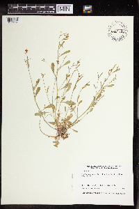 432972[1352094]Harris, Fred 940211994-05-17 United States, Minnesota, Olmsted, Olmsted Co.; cliff on S side of Root river valley. SE1/4 of NE1/4 of sW1/4 Sect. 18 T105N R12W;Dorer Memorial Hardwood State Forest;105N;12W;18, 43.898548 -92.308447 |
MIN:Plants | 437333[]Moore, John; et al. 162081944-05-26 United States, Minnesota, Dakota, Dakota County...Chimney Rock;;114N;17W;31, 44.637214 -92.903724 |
MIN:Plants | 445025[]Moore, John; Huff, N. 195191947-06-11 United States, Minnesota, Itasca, 1 mi. E of Grand Rapids.;;N;;, 47.237164 -93.508894 |
MIN:Plants | 448685[]Moore, John; Huff, N. 193251946-09-26 United States, Minnesota, Saint Louis, Sturgeon Lake.;George Washington State Forest;N;;, 47.67945 -93.04802 |
MIN:Plants | 458051[]Manning, Sara s.n.1884-06-08 United States, Minnesota, Goodhue, Central Point [pioneer town on Sand Point, Lake Pepin];Frontenac State Park;112N;13W;12, 44.519822 -92.319123 |
MIN:Plants | 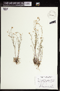 460804[1352097]Myhre, K. 18411992-05-18 United States, Minnesota, Cass, Cass Co.; Located 1 mile west of the Gull River; between the railroad tracks and highway 210; T 133N R 29W NE1/4 of NW1/ Cass Co.; Located 1 mile west of the Gull River; between the railroad tracks and highway 210; T 133N R 29W NE1/4 of NW1/4 of Sec 18. 133N 29W 18, 46.333217 -94.380017 |
MIN:Plants | 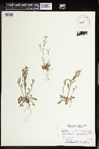 460812[1352098]Myhre, K. 16441992-05-04 United States, Minnesota, Cass, Cass Co.; Located 1 mile west of the Gull River; between the railroad tracks and highway 210; T 133N R 29W NE1/4 of NW1/ Cass Co.; Located 1 mile west of the Gull River; between the railroad tracks and highway 210; T 133N R 29W NE1/4 of NW1/4 of Sec 18. 133N 29W 18, 46.333217 -94.380017 |
MIN:Plants | 460816[]Myhre, K. 21601992-06-08 United States, Minnesota, Cass, Cass Co.; Located 1 mile west of the Gull River; between the railroad tracks and highway 210; T 133N R 29W NE1/4 of NW1/ Cass Co.; Located 1 mile west of the Gull River; between the railroad tracks and highway 210; T 133N R 29W NE1/4 of NW1/4 of Sec 18. 133N 29W 18, 46.333217 -94.380017 |
MIN:Plants | 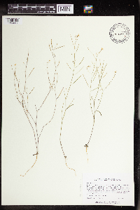 464348[1352091]Lee, Michael MDL13011996-06-21 United States, Minnesota, Fillmore, Fillmore Co.; 300ft. bluffs in the city limits of Rushford; T104N R8W SW1/4 SE1/4 SW1/4 Sec. 12;;104N;08W;12, 43.824788 -91.740421 |
MIN:Plants |  473813[1352095]Smith, Welby 207881992-07-13 United States, Minnesota, Wadena, Dry Sand Lake Wildlife Management Area. Wadena Co.; In Dry Sand Lake State Wildlife Management Area, on the west side of CSAH 30, about 2.5 miles south of Oylen Wadena Co.; In Dry Sand Lake State Wildlife Management Area, on the west side of CSAH 30, about 2.5 miles south of Oylen; T 135N R 33W NW1/4 of SW1/4 of sec 1. T135N R33W S1, 46.535518 -94.79 |
MIN:Plants |  475908[1352093]Myhre, K. 25471992-07-06 United States, Minnesota, Cass, Cass Co.; Located directly southeast of Harlan Lake; T 133N R 30W SW1/4 of NE1/4 of Sec 6;;133N;30W;6, 46.361961 -94.507142 |
MIN:Plants | 487830[]Sheldon, Edmund 17721892-07-00 United States, Minnesota, Crow Wing, Brainerd;;N;;, 46.358022 -94.200829 |
MIN:Plants |  514524[1352096]Myhre, K. 20311992-06-01 United States, Minnesota, Cass, Cass Co.; located 1.5 mi NE of the town of Pillager; T133N R30W NE1/4 of NE1/4 of Sec 9;;133N;30W;9, 46.347718 -94.464151 |
MIN:Plants | 463634[]Lee, Michael MDL16441997-05-26 United States, Minnesota, Wabasha, Dorer Memorial Hardwood State Forest. Wabasha Co.; Along the zumbro River at Rattlesnake Point, 1/4 mile north of the Olmsted County line; dolomite outcrops; Wabasha Co.; Along the zumbro River at Rattlesnake Point, 1/4 mile north of the Olmsted County line; dolomite outcrops; bluff prairie overlooking Lake Zumbro; T109N R14W NW1/4 of SW1/4 of sE1/4 Sec. 34. 109N 14W 34, 44.201874 -92.481055 |
MIN:Plants | 568953[]Moore, John; et al. 251641960-07-15 United States, Minnesota, Anoka, Anoka County...Along the S shore of Fish Lake.;Cedar Creek National History Area;034N;23W;, 45.428063 -93.203997 |
MIN:Plants | 583907[]Gunderson, R. 1201961-05-20 United States, Minnesota, Washington, Washington County ... St. Croix River, 3 mi. N of Stillwater.;Saint Croix National Riverway;030N;20W;, 45.09437 -92.76993 |
MIN:Plants | 585239[]Moore, John 258921962-05-08 United States, Minnesota, Houston, 8 mi. W of Houston;Dorer Memorial Hardwood State Forest;N;;, 43.763187 -91.728923 |
MIN:Plants | 680740[]Clemants, Steven 6551977-05-08 United States, Minnesota, Fillmore, Fillmore Co. North Branch Root River; T104N, R10W, Sec. 28, SE1/4 and Sec. 33 NE1/4.;Dorer Memorial Hardwood State Forest;104N;10W;, 43.803711 -92.029358 |
MIN:Plants | 680782[]Wheeler, Gerald 10011977-04-21 United States, Minnesota, Washington, Saint Croix National Riverway. Washington County ... Ca. 3 mi. NE of Stillwater of Hwy. 95. Adjacent to the St. Croix River. T30N, R19W [should be R20W], Sec. 11.. 030N 20W 11, 45.101186 -92.772117 |
MIN:Plants | 680871[]Wheeler, Gerald 10291977-04-26 United States, Minnesota, Chisago, Chisago Co. Approx. 1/2 mi E of the jct. of hwy 243 and hwy 95 on hwy 243. T33N R19W Sec.28.;;033N;19W;28, 45.318889 -92.724307 |
MIN:Plants | 689569[]Marshall, John s.n.1966-06-13 United States, Minnesota, Washington, Point Douglas.;;026N;20W;, 44.762233 -92.834041 |
MIN:Plants | 690907[]Wheeler, Gerald 25061978-05-13 United States, Minnesota, Goodhue, Goodhue Co. On the large bluff bordering the Mississippi River at Red Wing.;;N;;, 44.562468 -92.533801 |
MIN:Plants | 691466[]Clemants, Steven 11791978-06-09 United States, Minnesota, Chisago, Chisago County...Goose Creek, about 3 mi. NE of Harris...T36N, R21W, intersection of Sec. 13, 14, 23, 24.;;036N;21W;00, 45.600632 -92.960367 |
MIN:Plants | 695818[]Clemants, Steven 12861978-06-20 United States, Minnesota, Crow Wing, 1/2 mi. N of the town of Crow Wing. T144N, R31W, intersection of Sec. 16, 17, 19, 20.;;144N;31W;, 46.287206 -94.2925 |
MIN:Plants | 711399[]Smith, Welby 9751979-06-12 United States, Minnesota, Wabasha, Dorer Memorial Hardwood State Forest. T111N, R11W; SW1/4 Sec. 17. On a N-facing bluff overlooking Hwy. 61, ca. 6 mi. WNW of it's jct. with Hwy. 10 in Wabasha T111N, R11W; SW1/4 Sec. 17. On a N-facing bluff overlooking Hwy. 61, ca. 6 mi. WNW of it's jct. with Hwy. 10 in Wabasha.. 111N 11W 17, 44.410497 -92.158159 |
MIN:Plants | 722854[]Lustig, K. 2721979-05-20 United States, Minnesota, Anoka, Anoka County...Boot Lake SNA: 18 mi SE of Cambridge, sec.17, 18, 19, 20 T33N R22W.;Boot Lake Scientific Natural Area;033N;22W;00, 45.340658 -93.081463 |
MIN:Plants |  723835[1352092]Smith, Welby; et al. 25611980-06-20 United States, Minnesota, Cook, The southeast corner of Little Brick Island, in the Susie Island system, Lake Superior.;North Shore / Susie Islands, The Nature Conservancy;063N;07E;04, 47.9736111 -89.5677778 |
MIN:Plants | 724163[]Smith, Welby 20901980-05-10 United States, Minnesota, Wabasha, T109N, R09W, NW1/4 Sec. 8. Ca. 1 mi. E of Hwy. 84.;;109N;09W;8, 44.258009 -91.918671 |
MIN:Plants | 724393[]Smith, Welby 20691980-05-10 United States, Minnesota, Winona, T108N, R10W, NE1/4 SW1/4 Sec. 14. 0.15 mi. NE of the jct. of Co. Rd. 30 and 74, near the town of Beaver.;Whitewater Wildlife Management Area;108N;10W;14, 44.15652 -91.990286 |
MIN:Plants | 729187[]Berlin, N. 191979-05-16 United States, Minnesota, Goodhue, Wacouta Pond Natural Area, The Nature Conservancy. Goodhue Co. Wacouta Pond Natural Area: 5 mi SE of Red Wing. Portions of Sec.6, T112N, R13W and Sec.31,32, T113N, r13W. P Goodhue Co. Wacouta Pond Natural Area: 5 mi SE of Red Wing. Portions of Sec.6, T112N, R13W and Sec.31,32, T113N, r13W. Powerline right-of-way.. , 44.535146 -92.41987 |
MIN:Plants | 729200[]Berlin, N. 191979-05-16 United States, Minnesota, Goodhue, Wacouta Pond Natural Area, The Nature Conservancy. Goodhue Co. Wacouta Pond Natural Area: 5 mi SE of Red Wing. Portions of Sec.6, T112N, R13W and Sec.31, 32, T113N, R13W. Goodhue Co. Wacouta Pond Natural Area: 5 mi SE of Red Wing. Portions of Sec.6, T112N, R13W and Sec.31, 32, T113N, R13W. Powerline right of way. N , 44.535146 -92.41987 |
MIN:Plants | 738681[]Galatowitsch, S. 41982-04-24 United States, Minnesota, Wabasha, Wabasha County...Weaver Dunes: T109N R9W SE1/4 and E1/2 NE1/4 of Sec.7, NW1/4 and W1/2 NE1/4 of Sec.8;Kellogg-Weaver Dunes Scientific Natural Area / Kellogg-Weaver Dunes, The Nature Conservancy;109N;09W;00, 44.233108 -91.917245 |
MIN:Plants | 743906[]Ownbey, Gerald 66571980-09-20 United States, Minnesota, Houston, Houston Co. Twin Bluffs, 1.8 mi N of Iowa line at New Albin; on W side of rt. 26. T101N R4W Sec.26 NW1/4.;Dorer Memorial Hardwood State Forest;101N;04W;26, 43.522538 -91.282841 |
MIN:Plants | 749062[]Wheeler, Gerald 54031981-04-20 United States, Minnesota, Washington, Washington County ... Hwy 95, ca 1.5 mi N of Stillwater on Rte. 95 ... St. Croix River. T30N R20W sec. 14;Saint Croix National Riverway;030N;20W;14, 45.090515 -92.777311 |
MIN:Plants | 750204[]Almendinger, J. 22121980-09-20 United States, Minnesota, Crow Wing, Crow Wing Co.; 1/2 mi SE of St. Hwy 371, just S of Brainerd, NE of NE of S11 T44N R31W.;;044N;31W;11, 46.308709 -94.220169 |
MIN:Plants | 763772[]Hart, H. s.n. United States, Minnesota, Hennepin, Below Biology Building.;;N;;, 44.97441 -93.233002 |
MIN:Plants | 764429[]Hart, H. s.n.1922-05-30 United States, Minnesota, Hennepin, Near the foot of Bedford St.;;N;;, 44.9669 -93.20893 |
MIN:Plants | 770311[]Smith, Welby 76631983-05-18 United States, Minnesota, Wabasha, Kellogg-Weaver Dunes Scientific Natural Area / Kellogg-Weaver Dunes, The Nature Conservancy. Kellogg-Weaver Dunes State Scientific and Natural Area. Ca. 4 mi. SE of Kellogg, on the E side of Co. Rd. 84. NW1/4 NE Kellogg-Weaver Dunes State Scientific and Natural Area. Ca. 4 mi. SE of Kellogg, on the E side of Co. Rd. 84. NW1/4 NE1/4 Sec. 6, T109N, R09W.. 109N 09W 6, 44.272608 -91.938983 |
MIN:Plants | 777651[]Coffin, Barbara; Engstrom, D. 821051982-06-17 United States, Minnesota, Cook, Cook Co. T64N, R5E, SW, SW, Sec.25. Red Rock Bay; along Lake Superior;Grand Portage Indian Reservation / North Shore;063N;05E;25, 47.914337 -89.751755 |
MIN:Plants | 780439[]Ownbey, Gerald 69711985-06-02 United States, Minnesota, Washington, Buff across from Afton Alps ski area.;Afton State Park;027N;20W;02, 44.854763 -92.775046 |
MIN:Plants | 800197[]Cholewa, A. 15791989-05-05 United States, Minnesota, Washington, North Ravine, ca. 2 mi. W of railroad trail, slope adjacent to footbridge.;Carpenter Nature Center;026N;20W;04, 44.7699889 -92.8101917 |
MIN:Plants | 821079[]Berlin, N. 3051980-07-00 United States, Minnesota, Cook, Cook Co.; Susie Island Archipelago.;North Shore / Susie Islands, The Nature Conservancy;063N;07E;, 47.973776 -89.578978 |
MIN:Plants | 826174[]Bender, J. s.n.1986-05-02 United States, Minnesota, Washington, Washington Co, Belwin Outdoor Education Laboratory, T28N R20W, Afton twp.;Belwin Outdoor Education Laboratory;028N;20W;, 44.92523 -92.79982 |
MIN:Plants | 829689[]Nation, R. 10561993-06-17 United States, Minnesota, Winona, Winona Co. 3 mi S and 1/4 mi W of Weaver; T108N R09W NW1/4 of SW1/4 of Sec.8;Dorer Memorial Hardwood State Forest;108N;09W;8, 44.171422 -91.929435 |
MIN:Plants | 832399[]Moyle, J. 37391941-05-14 United States, Minnesota, Cass, Cass Co, near Hackensack;;140N;30W;, 46.936305 -94.469695 |
MIN:Plants | 833965[]Smith, Welby 139821988-05-03 United States, Minnesota, Washington, Saint Croix National Riverway. Washington County ... About 4 miles northeast of Stillwater ... St. Croix River. SE1/4 SW1/4 sec. 1 T 30N R 20W. 030N 20W 1, 45.115579 -92.751922 |
MIN:Plants |  836168[1352090]Smith, Welby 172881990-07-17 United States, Minnesota, Morrison, Camp Ripley Military Reservation. Camp Ripley Military Reservation Morrison Co. Along East Boundary Road, about 2.5 km N of the airfield. UTM: 394700E 510 Camp Ripley Military Reservation Morrison Co. Along East Boundary Road, about 2.5 km N of the airfield. UTM: 394700E 5107700N T131N R30W SE1/4 of NW1/4 of Sec 32. 131N 30W 32, 46.114584 -94.484628 |
MIN:Plants | 840469[]Boe, J. 930527111993-05-27 United States, Minnesota, Cass, Cass Co. Near Dry Sand Lake Wildlife Management Area; T135N R32W NE1/4 of NE1/4 of Sec 8.;;135N;32W;8, 46.520859 -94.749431 |
MIN:Plants |  841021[1352089]Smith, Welby 127091987-05-16 United States, Minnesota, Goodhue, Goodhue County...Hay Creek Recreation Area, about 2 mi S of Red Wing...SW1/4 NW1/4 sec.7, T112N R14W;Dorer Memorial Hardwood State Forest;112N;14W;07, 44.523613 -92.5458298 |
MIN:Plants | Arabidopsis lyrata subsp. kamchatica (Fischer ex de Candolle) O’Kane & Al-Shehbaz 487863[]Went, F. s.n.1951-09-18 United States, California, Alameda, Livermore, Alameda Co. |
MIN:Plants | Arabidopsis lyrata subsp. kamchatica (Fischer ex de Candolle) O’Kane & Al-Shehbaz 657005[]Noble, Mark; et al. 4801974-08-05 United States, Alaska, Muir Point; from site deglaciated ca. 1880.;Glacier Bay National Park;;;, 58.82694 -136.07722 |
MIN:Plants | 225500[]Cooper, William 661909-07-08 United States, Michigan, Keweenaw, Rock Harbor, Isle Royale;Isle Royale National Park;;;, 48.12083 -88.53333 |
Google Map
Google Maps is a web mapping service provided by Google that features a map that users can pan (by dragging the mouse) and zoom (by using the mouse wheel). Collection points are displayed as colored markers that when clicked on, displays the full information for that collection. When multiple species are queried (separated by semi-colons), different colored markers denote each individual species.