University of Minnesota
http://www.umn.edu/
612-625-5000
http://www.umn.edu/
612-625-5000
Minnesota Biodiversity Atlas
Bell Museum
Dataset: MIN-Plants
Taxa: Archidendron
Search Criteria: excluding cultivated/captive occurrences
1
Page 1, records 1-14 of 14
Bell Museum plants | |
 MIN:Plants | 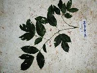 Archidendron glabrum K.Schum. & Lauterb. 923596[]Whitfeld, T.J.S. SA1E00702008-07-14 Papua New Guinea, Madang, Wanang Village, -5.238167 145.170983, 73m |
MIN:Plants | 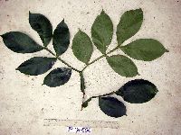 Archidendron ptenopum Verdc. 913427[]Weiblen, G.D. & Binatang Research Center WP3A05562007-07-17 Papua New Guinea, Madang, Wanang Village, -5.2373 145.177183, 115m |
MIN:Plants | 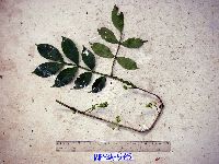 Archidendron ptenopum Verdc. 913425[]Weiblen, G.D. & Binatang Research Center WP3A05752007-07-06 Papua New Guinea, Madang, Wanang Village, -5.2373 145.177183, 115m |
MIN:Plants | 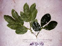 Archidendron ptenopum Verdc. 913429[]Weiblen, G.D. & Binatang Research Center WP3D07512007-02-14 Papua New Guinea, Madang, Wanang Village, -5.2373 145.177183, 115m |
MIN:Plants | 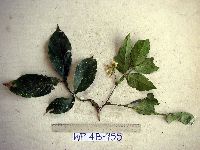 Archidendron ptenopum Verdc. 913426[]Weiblen, G.D. & Binatang Research Center WP4B09552007-08-15 Papua New Guinea, Madang, Wanang Village, -5.2373 145.177183, 115m |
MIN:Plants | 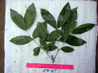 Archidendron lucyi F.Muell. 913440[]Weiblen, G.D. & Binatang Research Center WP4E08272006-10-27 Papua New Guinea, Madang, Wanang Village, -5.2373 145.177183, 115m |
MIN:Plants | 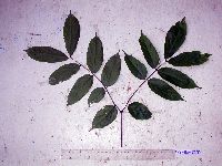 Archidendron glabrum K.Schum. & Lauterb. 913439[]Weiblen, G.D. & Binatang Research Center WS3A20782006-04-08 Papua New Guinea, Madang, Wanang Village, -5.229583 145.178467, 115m |
MIN:Plants | 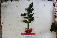 Archidendron aruense (Warb.) de Wit 923001[]Ctvrtecka, R. 40952009-02-17 Papua New Guinea, Madang, Mis Village, -5.15 145.783, 10m |
MIN:Plants | 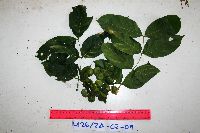 Archidendron glabrum K.Schum. & Lauterb. 923027[]Ctvrtecka, R. 42682009-02-24 Papua New Guinea, Madang, Mis Village, -5.15 145.783, 10m |
MIN:Plants | 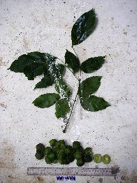 Archidendron lucyi F.Muell. 923000[]Ctvrtecka, R. 31082008-11-05 Papua New Guinea, Madang, Wanang Village, -5.23088 145.182, 115m |
MIN:Plants | 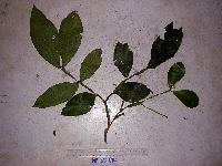 Archidendron ptenopum Verdc. 913424[]Weiblen, G. D. & Binatang Research Center WP3B0614 Papua New Guinea, Madang, Wanang Village, -5.2373 145.177183, 115m |
MIN:Plants | Archidendron glabrum K.Schum. & Lauterb. 923610[]T. J. S. Whitfeld 7512008-07-16 Papua New Guinea, Madang, -5.25 145.266667, 115m |
MIN:Plants | 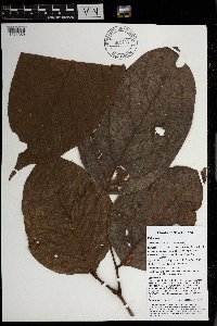 Archidendron aruense (Warb.) de Wit 969763[1371359]Weiblen, G. D. & Binatang Research Center NP1A00692013-05-24 Papua New Guinea, Madang, Numba, -5.7222 145.2714, 1200m |
MIN:Plants |  Archidendron aruense (Warb.) de Wit 969771[1371351]Weiblen, G. D. & Binatang Research Center NP2A00792013-06-14 Papua New Guinea, Madang, Numba, -5.7222 145.2714, 1200m |
1
Page 1, records 1-14 of 14
Google Map
Google Maps is a web mapping service provided by Google that features a map that users can pan (by dragging the mouse) and zoom (by using the mouse wheel). Collection points are displayed as colored markers that when clicked on, displays the full information for that collection. When multiple species are queried (separated by semi-colons), different colored markers denote each individual species.