University of Minnesota
http://www.umn.edu/
612-625-5000
http://www.umn.edu/
612-625-5000
Minnesota Biodiversity Atlas
Bell Museum
Dataset: MIN-Plants
Taxa: Armoracia
Search Criteria: excluding cultivated/captive occurrences
1
Page 1, records 1-21 of 21
Bell Museum plants | |
 MIN:Plants | Armoracia rusticana P. Gaertner, B. Meyer & Scherbius 568676[]Moore, John 249741960-06-14 United States, Minnesota, Kittson, Kittson County...rail road right of way 1 mile east of Noyes;;;;, 48.997485 -97.18245 |
MIN:Plants | Armoracia rusticana P. Gaertner, B. Meyer & Scherbius 622058[]Stevens, O. 32861971-06-06 United States, North Dakota, Cass, Cass County...Fargo |
MIN:Plants | Armoracia rusticana P. Gaertner, B. Meyer & Scherbius 120351[]Hollinshead, C. 652000-05-00 United States, Minnesota, [no further data];;;;, 46 -94 |
MIN:Plants | Armoracia rusticana P. Gaertner, B. Meyer & Scherbius 120357[]Taylor, B. T1601891-06-00 United States, Minnesota, Waseca, Janesville;;N;;, 44.116078 -93.708004 |
MIN:Plants | Armoracia rusticana P. Gaertner, B. Meyer & Scherbius 120359[]Sandberg, John s.n.1884-06-00 United States, Minnesota, Goodhue, Red Wing.;;113N;14W;, 44.555216 -92.495543 |
MIN:Plants | Armoracia rusticana P. Gaertner, B. Meyer & Scherbius 270846[]Budde, C. s.n.1896-05-23 United States, Minnesota, Blue Earth, Vic. of Minnesota St, Mankato.;;N;;, 44.163578 -93.9994 |
MIN:Plants | Armoracia rusticana P. Gaertner, B. Meyer & Scherbius 288520[]Aiton, G. s.n.1891-00-00 United States, Minnesota, Hennepin, Near Minneapolis.;;N;;, 44.979965 -93.263836 |
MIN:Plants | Armoracia rusticana P. Gaertner, B. Meyer & Scherbius 352707[]Seim, A. 361937-06-19 United States, Minnesota, Ramsey, S of University Ave, opposite the Y.C.M.A, Midway district, St. Paul.;;029N;23W;, 44.992077 -93.166387 |
MIN:Plants | Armoracia rusticana P. Gaertner, B. Meyer & Scherbius 367078[]Carlander, K. s.n.1940-06-25 United States, Minnesota, Lake of the Woods, Near Zippel.;;N;;, 48.87254 -94.87398 |
MIN:Plants | 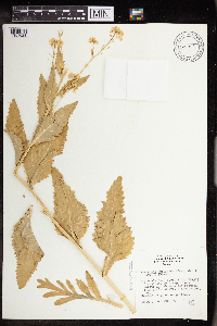 Armoracia rusticana P. Gaertner, B. Meyer & Scherbius 514946[1351628]Schimpf, D. 901982-06-18 United States, Minnesota, Saint Louis, St. Louis Co. T50N, R14W, NE1/4S15; vacant lot above alley between 1125 Brainerd Ave. & Mississippi Ave.;;050N;14W;15, 46.814831 -92.100333 |
MIN:Plants | Armoracia rusticana P. Gaertner, B. Meyer & Scherbius 554464[]Moore, John 232121957-06-15 United States, Minnesota, Pipestone, Pipestone Co.; 1 mi. south of Trosky.;;105N;45W;, 43.892269 -96.245863 |
MIN:Plants | Armoracia rusticana P. Gaertner, B. Meyer & Scherbius 578647[]Ownbey, Gerald 31731962-06-21 United States, Minnesota, Clearwater, Itasca State Park. T143N, R36W, NE1/4 Sec. 2.;Itasca State Park;143N;36W;2, 47.231973 -95.201528 |
MIN:Plants | Armoracia rusticana P. Gaertner, B. Meyer & Scherbius 580359[]Stevens, O. 21831960-06-02 United States, Minnesota, Clay, Kragnes;;141N;48W;, 47.020558 -96.75325 |
MIN:Plants | 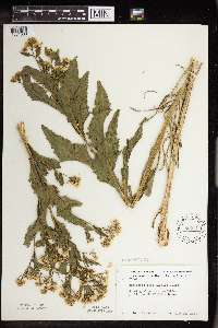 Armoracia rusticana P. Gaertner, B. Meyer & Scherbius 592147[1351630]Moore, John 266471964-05-28 United States, Minnesota, Blue Earth, Along the roadside, 1/2 mi. S of Eagle Lake.;;N;;, 44.170846 -93.885759 |
MIN:Plants | 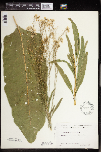 Armoracia rusticana P. Gaertner, B. Meyer & Scherbius 592402[1351629]Westkaemper, Remberta s.n.1965-06-00 United States, Minnesota, Stearns, Stearns Co. St. Cloud.;;N;;, 45.55 -94.166667 |
MIN:Plants | 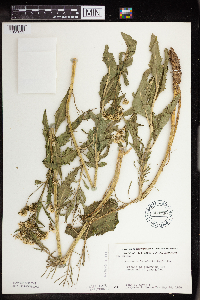 Armoracia rusticana P. Gaertner, B. Meyer & Scherbius 603720[1351631]Moore, John; et al. 268211966-05-28 United States, Minnesota, Blue Earth, Blue Earth County...At the N end of Long Lake.;;;;, 44.221533 -93.85229 |
MIN:Plants | Armoracia rusticana P. Gaertner, B. Meyer & Scherbius 616827[]Moore, John; et al. 4571969-08-27 United States, Minnesota, Crow Wing, Crow Wing Natural History Area, Crow Wing County...N of old barn, SW1/4 Sec. 6, Garrison Twp.;Crow Wing Natural Area;044N;28W;06, 46.323097 -93.926287 |
MIN:Plants | 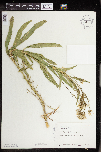 Armoracia rusticana P. Gaertner, B. Meyer & Scherbius 663849[1351632]Grether, David 88011978-06-01 United States, Minnesota, Sherburne, Becker. Northern States Power plant.;;N;;, 45.393299 -93.87692 |
MIN:Plants | Armoracia rusticana P. Gaertner, B. Meyer & Scherbius 763918[]Lakela, Olga s.n.1992-06-20 United States, Minnesota, Hennepin, Lake Minnetonka;;N;;, 44.924687 -93.603582 |
MIN:Plants | 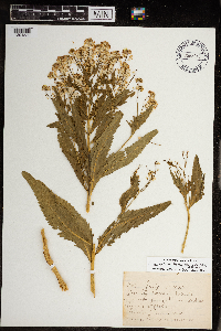 Armoracia rusticana P. Gaertner, B. Meyer & Scherbius 968847[1391530]Gammon, Inaz 1903-07-15 United States, Minnesota, Hennepin, 44.903296 -93.566346 |
MIN:Plants | 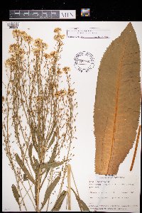 Armoracia rusticana P. Gaertner, B. Meyer & Scherbius 972686[1398239]Verbelen, E. 1481974-05-18 Belgium, Kiel |
1
Page 1, records 1-21 of 21
Google Map
Google Maps is a web mapping service provided by Google that features a map that users can pan (by dragging the mouse) and zoom (by using the mouse wheel). Collection points are displayed as colored markers that when clicked on, displays the full information for that collection. When multiple species are queried (separated by semi-colons), different colored markers denote each individual species.