University of Minnesota
http://www.umn.edu/
612-625-5000
http://www.umn.edu/
612-625-5000
Minnesota Biodiversity Atlas
Bell Museum
Dataset: MIN-Plants
Taxa: Digitalis
Search Criteria: excluding cultivated/captive occurrences
1
Page 1, records 1-15 of 15
Bell Museum plants | |
 MIN:Plants | 605982[]Scoggan, H. 152331964-07-02 Canada, British Columbia, Vancouver...45 mi. east of city. |
MIN:Plants | Digitalis grandiflora Lamarck 493969[]Pomroy, Deborah DLP 19922004-07-23 United States, Minnesota, Saint Louis, St. Louis County, Hoyt Lakes. T59N R14W NW1/4 of SE1/4 Sec 20. 1/2 mi SSE of entrance of PolyMet Mine, 4.5 mi N of Hoyt Lakes. On both sides of Co. Rd. 110, in ditches and beyond into spruce-fir-aspen-birch forest.. 059N 14W 20, 47.580136 -92.149115 |
MIN:Plants | Digitalis lanata J.F. Ehrhart 435858[]Judziewicz, E. 107171993-07-24 United States, Minnesota, Washington, Washington Co.; T30N-R20W, Sec. 16, SE of SE; on northeast rim of Fairy Falls canyon, abut 200 meters southeast of the Falls (north outskirts of Stillwater). 030N 20W 16, 45.080953 -92.804939 |
MIN:Plants | Digitalis grandiflora Lamarck 598395[]Walton, G. 25411997-07-22 United States, Minnesota, Saint Louis, St. Louis Co.; T50N, R14W, nw 1/4 of sw 1/4 of sec. 13. Corner of 24th Ave. East and Superior Street, Duluth;;050N;14W;13, 46.7833 -92.1 |
MIN:Plants | Digitalis lanata J.F. Ehrhart 460632[]Anonymous s.n.1999-09-03 United States, Minnesota, Washington, Washington Co, Stillwater, private property at North First Street. T30N R20W.;;030N;20W;, 45.05646 -92.806206 |
MIN:Plants | Digitalis lanata J.F. Ehrhart 531551[]Briggs, John De Q. s.n.1956-09-30 United States, Minnesota, Washington, Washington County...Near the Stoltze Ranch at May's Lake, ca. 0.9 mile south of highway US 12, ca. 0.5 mile west of etc.;;028N;20W;04, 44.85487 -92.811356 |
MIN:Plants | Digitalis lanata J.F. Ehrhart 531552[]Briggs, John De Q. s.n.1956-10-11 United States, Minnesota, Washington, Washington County...Near the Stoltze ranch at May's Lake, ca. 0.9 mile south of highway US 12, ca. 0.5 mile south of road to Afton.. 028N 20W 4, 44.85487 -92.811356 |
MIN:Plants | Digitalis lanata J.F. Ehrhart 541513[]Morley, T. 9321957-08-03 United States, Minnesota, Washington, Washington County...In the northeast quarter of section 4, Afton Township, in the J.R. Stoltze estate. Go 0.9 miles S of US 12 on County Road 3, then 0.5 miles west on a private road, then 0.4 miles north.. 028N 20W 4, 44.945093 -92.806979 |
MIN:Plants | Digitalis lanata J.F. Ehrhart 805739[]Almendinger, J. s.n.1987-07-01 United States, Minnesota, Washington, Washington Co.; Fairy Falls, Stillwater. T30N, R20W, SW1/4 SW1/4 Sec. 16. Just SE of falls. NE side of gorge.;;030N;20W;16, 45.081014 -92.820732 |
MIN:Plants | Digitalis lanata J.F. Ehrhart 841170[]Smith, Welby 137961987-08-11 United States, Minnesota, Washington, Washington Co. About 3 mi NW of Afton; SW1/4 NE1/4 sec.4, T28N R20W;;028N;20W;4, 44.943753 -92.809329 |
MIN:Plants | Digitalis lanata J.F. Ehrhart 473617[]Glenn-Lewin, David; Ver Hoef, Jay 1986-06-30 United States, Minnesota, Washington, SE1/4 SE1/4 of section.;;030N;20W;16, 45.080863 -92.804956 |
MIN:Plants |  972325[1395875]Janssens, J. 75/3341975-07-30 United Kingdom, Scotland, Isle of Skye, Portree, 482/441 |
MIN:Plants | 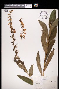 972326[1395876]Janssens, J. 75/2741975-07-27 Belgium |
MIN:Plants |  972581[1398131]Hoch, F. s.n.1859-00-00 Norway, Hardanger |
MIN:Plants | 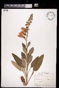 972582[1398132]Janssens, J. 831973-07-03 Belgium, Grande Fagne, 560m |
1
Page 1, records 1-15 of 15
Google Map
Google Maps is a web mapping service provided by Google that features a map that users can pan (by dragging the mouse) and zoom (by using the mouse wheel). Collection points are displayed as colored markers that when clicked on, displays the full information for that collection. When multiple species are queried (separated by semi-colons), different colored markers denote each individual species.