University of Minnesota
http://www.umn.edu/
612-625-5000
http://www.umn.edu/
612-625-5000
Minnesota Biodiversity Atlas
Bell Museum
Dataset: MIN-Plants
Taxa: Endiandra
Search Criteria: excluding cultivated/captive occurrences
1
Page 1, records 1-15 of 15
Bell Museum plants | |
 MIN:Plants |  914384[]Weiblen, G.D. & Binatang Research Center WP1B00512006-03-09 Papua New Guinea, Madang, Wanang Village, -5.2373 145.177183, 115m |
MIN:Plants | 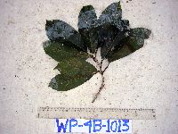 914080[]Weiblen, G.D. & Binatang Research Center WP4B10132007-09-01 Papua New Guinea, Madang, Wanang Village, -5.2373 145.177183, 115m |
MIN:Plants |  914079[]Weiblen, G.D. & Binatang Research Center WP5D11662007-05-14 Papua New Guinea, Madang, Wanang Village, -5.2373 145.177183, 115m |
MIN:Plants | Endiandra magnilimba Kosterm. 897273[]Weiblen, G.D. TP4321996-07-31 Papua New Guinea, Simbu, O-Pio 1 ha plot, block 18, Crater Mountain Wildlife Management Area, -6.788611 145.036667, 550m |
MIN:Plants | Endiandra magnilimba Kosterm. 897569[]Weiblen, G.D. TP4461996-07-31 Papua New Guinea, Simbu, O-Pio 1 ha plot, block 18, Crater Mountain Wildlife Management Area, -6.788611 145.036667, 550m |
MIN:Plants | Endiandra magnilimba Kosterm. 897607[]Weiblen, G.D. TP4411996-07-31 Papua New Guinea, Simbu, O-Pio 1 ha plot, block 18, Crater Mountain Wildlife Management Area, -6.788611 145.036667, 550m |
MIN:Plants | 896721[]Weiblen, G.D. TP0311996-07-31 Papua New Guinea, Simbu, O-Pio 1 ha plot, block 2, Crater Mountain Wildlife Management Area, -6.788611 145.036667, 550m |
MIN:Plants | 896665[]Weiblen, G.D. TP1661996-07-31 Papua New Guinea, Simbu, O-Pio 1 ha plot, block 8, Crater Mountain Wildlife Management Area, -6.788611 145.036667, 550m |
MIN:Plants | Endiandra magnilimba Kosterm. 897614[]Weiblen, G.D. TP4411996-07-31 Papua New Guinea, Simbu, O-Pio 1 ha plot, block 18, Crater Mountain Wildlife Management Area, -6.788611 145.036667, 550m |
MIN:Plants | Endiandra forbesii Gamble 897969[]Weiblen, G.D. TP3941996-07-31 Papua New Guinea, Simbu, O-Pio 1 ha plot, block 16, Crater Mountain Wildlife Management Area, -6.788611 145.036667, 550m |
MIN:Plants |  923700[]Whitfeld, T.J.S. PC1A00062008-08-15 Papua New Guinea, Madang, Wanang village, -5.237483 145.115733, 129m |
MIN:Plants | 913305[]Weiblen, G.D. WP1Z30152008-04-02 Papua New Guinea, Madang, Wanang village, -5.2373 145.177183, 115m |
MIN:Plants | Endiandra forbesii Gamble 897868[]G. D. Weiblen TP3941996-07-31 Papua New Guinea, Simbu, O-Pio 1 ha plot, block 16, Crater Mountain Wildlife Management Area, 6.788611 -145.036667, 550m |
MIN:Plants | 914081[]Weiblen, G. D. WP3D07122007-02-09 Papua New Guinea, Madang, -5.2373 145.17718, 115m |
MIN:Plants | 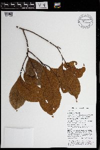 Endiandra brassii C.K.Allen 969892[1371506]Weiblen, G. D. & Binatang Research Center NP2B01652014-04-01 Papua New Guinea, Madang, Numba, -5.7222 145.2714, 1200m |
1
Page 1, records 1-15 of 15
Google Map
Google Maps is a web mapping service provided by Google that features a map that users can pan (by dragging the mouse) and zoom (by using the mouse wheel). Collection points are displayed as colored markers that when clicked on, displays the full information for that collection. When multiple species are queried (separated by semi-colons), different colored markers denote each individual species.