University of Minnesota
http://www.umn.edu/
612-625-5000
http://www.umn.edu/
612-625-5000
Minnesota Biodiversity Atlas
Bell Museum
Dataset: MIN-Plants
Taxa: Erythrospermum
Search Criteria: excluding cultivated/captive occurrences
1
Page 1, records 1-7 of 7
Bell Museum plants | |
 MIN:Plants | 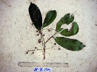 Erythrospermum candidum Becc. 916779[]Weiblen, G.D. & Binatang Research Center WP3A13052007-07-12 Papua New Guinea, Madang, Wanang Village, -5.2373 145.177183, 115m |
MIN:Plants | 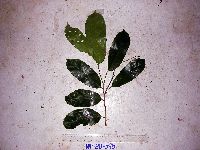 Erythrospermum candidum Becc. 916772[]Weiblen, G.D. & Binatang Research Center WP3B05952007-06-25 Papua New Guinea, Madang, Wanang Village, -5.2373 145.177183, 115m |
MIN:Plants | 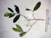 Erythrospermum candidum Becc. 916725[]Weiblen, G.D. & Binatang Research Center WP4C08582007-04-18 Papua New Guinea, Madang, Wanang Village, -5.2373 145.177183, 115m |
MIN:Plants | 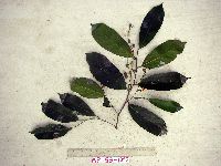 Erythrospermum candidum Becc. 916768[]Weiblen, G.D. & Binatang Research Center WP5B10922007-10-08 Papua New Guinea, Madang, Wanang Village, -5.2373 145.177183, 115m |
MIN:Plants | 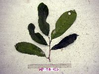 Erythrospermum candidum Becc. 916775[]Weiblen, G.D. & Binatang Research Center WP5B11262007-10-06 Papua New Guinea, Madang, Wanang Village, -5.2373 145.177183, 115m |
MIN:Plants | Erythrospermum candidum Becc. 922090[]Ctvrtecka, R. 24012008-09-29 Papua New Guinea, Madang, Wanang Village, -5.23088 145.182, 115m |
MIN:Plants | 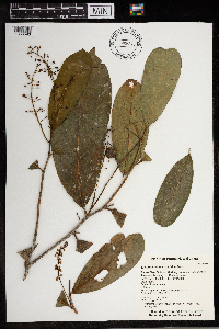 Erythrospermum candidum Becc. 0965849[1356593]Whitfeld, T. J. S. 2081b2019-02-16 Papua New Guinea, Madang, Wanang Conservation Area, overhanging the Digitam Creek, -5.230756 145.098243, 150m |
1
Page 1, records 1-7 of 7
Google Map
Google Maps is a web mapping service provided by Google that features a map that users can pan (by dragging the mouse) and zoom (by using the mouse wheel). Collection points are displayed as colored markers that when clicked on, displays the full information for that collection. When multiple species are queried (separated by semi-colons), different colored markers denote each individual species.