University of Minnesota
http://www.umn.edu/
612-625-5000
http://www.umn.edu/
612-625-5000
Minnesota Biodiversity Atlas
Bell Museum
Dataset: MIN-Plants
Taxa: Fagopyrum
Search Criteria: excluding cultivated/captive occurrences
1
Page 1, records 1-24 of 24
Bell Museum plants | |
 MIN:Plants |  Fagopyrum esculentum Moench 477824[1085179]Wheeler, Gerald 203651999-08-18 United States, Minnesota, Renville, Ca. 1.8 mi. W of Bird Island on Rte. 212; 0.5 mi. W of the jct. of Rte. 69 and RR tracks. W1/2 NW1/4 NE1/4 of section;;115N;34W;16, 44.767456 -94.932268 |
MIN:Plants |  Fagopyrum esculentum Moench 101809[1085189]Ainslie, G. 13161902-06-21 United States, Minnesota, Olmsted, Rochester;;106N;14W;, 43.97834 -92.49834 |
MIN:Plants |  Fagopyrum esculentum Moench 101810[1085186]Leonard, W. 101875-08-00 United States, Minnesota, Winona, [no further data];;;;, 44.0333 -91.6333 |
MIN:Plants |  Fagopyrum esculentum Moench 101811[1085190]Hammond, George 351881-05-00 United States, Minnesota, Wabasha, Lake City.;;111N;12W;, 44.449412 -92.266844 |
MIN:Plants | 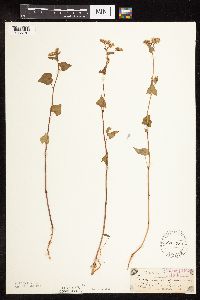 Fagopyrum esculentum Moench 101813[1085187]Sandberg, John s.n.1885-07-00 United States, Minnesota, Goodhue, Red Wing.;;113N;14W;, 44.562468 -92.533801 |
MIN:Plants | 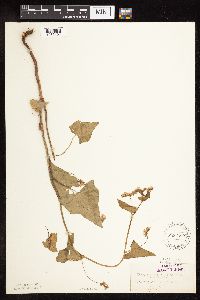 Fagopyrum esculentum Moench 101814[1085194]Herrick, C. s.n.1876-07-27 United States, Minnesota, Hennepin, Minneapolis;;N;;, 44.979965 -93.263836 |
MIN:Plants | 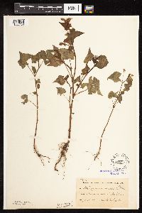 Fagopyrum esculentum Moench 101815[1085188]Taylor, B. T7171891-07-00 United States, Minnesota, Blue Earth, Minnesota Lake.;;104N;25W;, 43.837942 -93.856271 |
MIN:Plants | 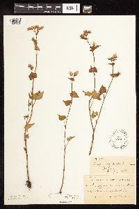 Fagopyrum esculentum Moench 101817[1085191]Ballard, C. B3801891-07-00 United States, Minnesota, Scott, Jordan, Scott Co.;;114N;23W;, 44.66532 -93.627759 |
MIN:Plants | 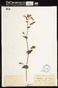 Fagopyrum esculentum Moench 101818[1085181]Kassube, J. s.n.1877-00-00 United States, Minnesota, Hennepin, Minneapolis;;N;;, 44.979965 -93.263836 |
MIN:Plants | 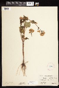 Fagopyrum esculentum Moench 277571[1085184]Hotchkiss, N.; Jones, Percy 3961930-08-15 United States, Minnesota, Clay, Eglon Twp.;;139N;44W;, 46.844837 -96.236714 |
MIN:Plants | 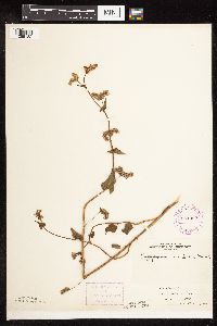 Fagopyrum esculentum Moench 281362[1085182]Roberts, Thomas s.n.1878-08-16 United States, Minnesota, Hennepin, Minneapolis;;N;;, 44.979965 -93.263836 |
MIN:Plants | 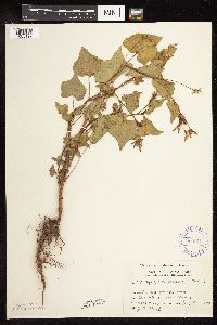 Fagopyrum esculentum Moench 289619[1085192]Moyle, J. 7881933-07-08 United States, Minnesota, Clearwater, Itasca Park. Forest Nursery. SE1/4 SE1/4 Sec. 2, T143N, R36W.;Itasca State Park;143N;36W;2, 47.231974 -95.201528 |
MIN:Plants |  Fagopyrum esculentum Moench 356306[1085193]Stevenson, J. 1521912-07-12 United States, Minnesota, Beltrami, Bemidji;;N;;, 47.536341 -94.82277 |
MIN:Plants |  Fagopyrum esculentum Moench 413150[1085185]Moore, John; Moore, Marjorie 111551939-07-26 United States, Minnesota, Lake of the Woods, 1/2 mi. W of Pine Creek, Angle Inlet.;Northwest Angle;168N;34W;, 49.346587 -95.047469 |
MIN:Plants |  Fagopyrum esculentum Moench 445849[1085180]Moore, John; Huff, N. 180611945-07-27 United States, Minnesota, Morrison, 1 mi. SE of Little Falls.;;N;;, 45.966116 -94.34777 |
MIN:Plants |  Fagopyrum esculentum Moench 592320[1085177]Westkaemper, Remberta s.n.1964-06-00 United States, Minnesota, Stearns, Stearns Co. St. Joseph. St. Benedict's [College] farm.;;124N;29W;, 45.564772 -94.317966 |
MIN:Plants |  Fagopyrum esculentum Moench 623091[1085183]Moore, John 273921971-06-23 United States, Minnesota, Anoka, Along the S line of Sec. 35, Bethel Twp, Cedar Creek Natural History Area.;Cedar Creek National History Area;034N;23W;35, 45.305363 -93.296211 |
MIN:Plants |  Fagopyrum esculentum Moench 681713[1085178]Gustitus, J. 731973-10-06 United States, Minnesota, Dakota, Hastings;;115N;17W;, 44.743301 -92.852427 |
MIN:Plants |  Fagopyrum esculentum Moench 711652[1085173]Smith, Welby 17301979-08-30 United States, Minnesota, Goodhue, T114N, R16W, SW14 Sec. 15. 3/8 mi. NW of where E bound co. 18 crosses the tracks of St. Paul and Pacific R.R.;;114N;16W;15, 44.676349 -92.727265 |
MIN:Plants |  Fagopyrum esculentum Moench 724634[1085175]Smith, Welby 33711980-08-17 United States, Minnesota, Wright, Wright Co. T119N, R25W, NW1/4 NE1/4 Sec. 15. Between Hwy. 55 and Soo Line R.R. tracks, ca. 1/4 mi. NW of the springs wa Wright Co. T119N, R25W, NW1/4 NE1/4 Sec. 15. Between Hwy. 55 and Soo Line R.R. tracks, ca. 1/4 mi. NW of the springs wayside.. 119N 25W 15, 45.118983 -93.814095 |
MIN:Plants | 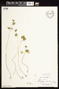 Fagopyrum esculentum Moench 744664[1085176]Converse, C. 22711982-08-24 United States, Minnesota, Otter Tail, Otter Tail Preserve: T131N, R44W, SE1/2 of Sec. 17.;Ottertail Prairie Scientific Natural Area;131N;44W;17, 46.159245 -96.235364 |
MIN:Plants | 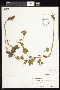 Fagopyrum esculentum Moench 772947[1085174]Boe, J. 9971979-07-21 United States, Minnesota, Roseau, On the embankment of Bednar Flowage. Sec. 34, R35W, T161N.;;161N;35W;34, 48.720177 -95.144524 |
MIN:Plants | 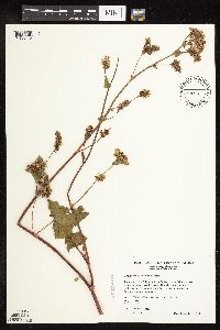 Fagopyrum esculentum Moench 508936[1085172]Wheeler, Gerald 204921999-09-09 United States, Minnesota, McLeod, Glencoe-Isaac Walton Wildlife Management Area. McLeod County ... Ca. 2 mi. SW of Glencoe; Isaac Walton Game Refuge; where unmarked county road crosses RR tracks ... W1/2 NW1/4 NE1/4 Sec. 21 T115N R28W (Glencoe 21). 115N 28W 21, 44.754257 -94.202747 |
MIN:Plants | 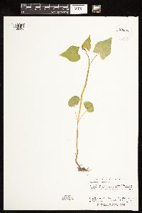 Fagopyrum esculentum Moench 938326[1122148]Holmstrom, R.; Kerns, Courtney 02002012-07-11 United States, Minnesota, Saint Louis, Just E of Itasca County boundary. About 2.7 km W of Hwy 73 and Cty Rd 18 junction. SE of NW of section.;;054N;21W;06, 47.1902778 -93.0572222 |
1
Page 1, records 1-24 of 24
Google Map
Google Maps is a web mapping service provided by Google that features a map that users can pan (by dragging the mouse) and zoom (by using the mouse wheel). Collection points are displayed as colored markers that when clicked on, displays the full information for that collection. When multiple species are queried (separated by semi-colons), different colored markers denote each individual species.