University of Minnesota
http://www.umn.edu/
612-625-5000
http://www.umn.edu/
612-625-5000
Minnesota Biodiversity Atlas
Bell Museum
Dataset: MIN-Plants
Taxa: Garcinia
Search Criteria: excluding cultivated/captive occurrences
1
Page 1, records 1-40 of 40
Bell Museum plants | |
 MIN:Plants |  Garcinia madruno (Kunth) Hammel 498037[1299122]Aguilar, Reinaldo 8201992-01-15 Costa Rica, Puntarenas: Reserva Forestal Golfo Dulce Aguabuena. Sector sur.;;;;, 8.7055559 -83.5250015, 50 - 150m |
MIN:Plants |  Garcinia dulcis Kurz 920714[]Whitfeld, T.J.S. PA1A00012008-08-13 Papua New Guinea, Madang, Wanang Village, -5.237483 145.115733, 129m |
MIN:Plants |  Garcinia assugu Lauterb. 921356[]Whitfeld, T.J.S. PA5B02612008-08-14 Papua New Guinea, Madang, Wanang Village, -5.237483 145.115733, 129m |
MIN:Plants |  Garcinia ledermannii Lauterbach 921366[]Whitfeld, T.J.S. PC1A00072008-09-03 Papua New Guinea, Madang, Wanang Village, -5.2243 145.07235, 115m |
MIN:Plants |  Garcinia hunsteinii Lauterb. 923659[]Whitfeld, T.J.S. PC4A02282008-09-04 Papua New Guinea, Madang, Wanang Village, -5.2243 145.07235, 115m |
MIN:Plants | Garcinia ledermannii Lauterbach 923653[]Whitfeld, T.J.S. SB4D02732008-07-19 Papua New Guinea, Madang, Wanang Village, -5.242633 145.166733, 113m |
MIN:Plants |  Garcinia ledermannii Lauterbach 923616[]Whitfeld, T.J.S. SB5D03632008-07-19 Papua New Guinea, Madang, Wanang Village, -5.242633 145.166733, 113m |
MIN:Plants |  Garcinia dulcis Kurz 912911[]Weiblen, G.D. & Binatang Research Center WP1C22342006-05-20 Papua New Guinea, Madang, Wanang Village, -5.2373 145.177183, 115m |
MIN:Plants |  Garcinia hunsteinii Lauterb. 912913[]Weiblen, G.D. & Binatang Research Center WP1C22662006-05-22 Papua New Guinea, Madang, Wanang Village, -5.2373 145.177183, 115m |
MIN:Plants | 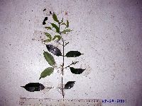 Garcinia hunsteinii Lauterb. 912917[]Weiblen, G.D. & Binatang Research Center WP2A21302006-03-31 Papua New Guinea, Madang, Wanang Village, -5.2373 145.177183, 115m |
MIN:Plants | 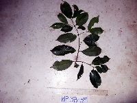 Garcinia maluensis Lauterb. 912909[]Weiblen, G.D. & Binatang Research Center WP3B05912007-06-23 Papua New Guinea, Madang, Wanang Village, -5.2373 145.177183, 115m |
MIN:Plants | 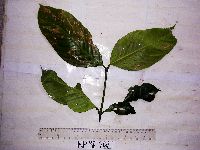 Garcinia dulcis Kurz 912912[]Weiblen, G.D. & Binatang Research Center WP3E26272006-09-18 Papua New Guinea, Madang, Wanang Village, -5.2373 145.177183, 115m |
MIN:Plants | 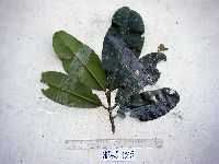 Garcinia latissima Miq. 912910[]Weiblen, G.D. & Binatang Research Center WP4B10032007-08-11 Papua New Guinea, Madang, Wanang Village, -5.2373 145.177183, 115m |
MIN:Plants | 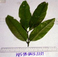 Garcinia ledermannii Lauterbach 912920[]Weiblen, G.D. & Binatang Research Center WS1B22312006-07-18 Papua New Guinea, Madang, Wanang Village, -5.229583 145.178467, 115m |
MIN:Plants |  Garcinia dulcis Kurz 912889[]Weiblen, G.D. & Binatang Research Center WS5E11762007-10-20 Papua New Guinea, Madang, Wanang Village, -5.229583 145.178467, 115m |
MIN:Plants |  Garcinia ledermannii Lauterbach 923189[]Ctvrtecka, R. 26632008-10-14 Papua New Guinea, Madang, Baitabag Village, -5.13333 145.767, 50m |
MIN:Plants |  Garcinia maluensis Lauterb. 923216[]Ctvrtecka, R. 16032008-08-05 Papua New Guinea, Madang, Mis Village, -5.15 145.783, 10m |
MIN:Plants | 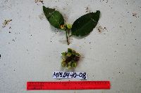 Garcinia cymosa (K.Schum.) I.M.Turner & P.F.Stevens 923215[]Ctvrtecka, R. 26872008-10-14 Papua New Guinea, Madang, Mis Village, -5.15 145.783, 10m |
MIN:Plants |  Garcinia hollrungii Lauterb. 923218[]Ctvrtecka, R. 22042008-09-15 Papua New Guinea, Madang, Wanang Village, -5.23088 145.182, 115m |
MIN:Plants |  Garcinia assugu Lauterb. 923217[]Ctvrtecka, R. 31202008-11-05 Papua New Guinea, Madang, Wanang Village, -5.23088 145.182, 115m |
MIN:Plants | Garcinia hollrungii Lauterb. 896673[]Weiblen, G.D. TP1771996-07-31 Papua New Guinea, Simbu, O-Pio 1 ha plot, block 8, Crater Mountain Wildlife Management Area, -6.788611 145.036667, 550m |
MIN:Plants | Garcinia maluensis Lauterb. 896678[]Weiblen, G.D. TP1611996-07-31 Papua New Guinea, Simbu, O-Pio 1 ha plot, block 8, Crater Mountain Wildlife Management Area, -6.788611 145.036667, 550m |
MIN:Plants | Garcinia hollrungii Lauterb. 896718[]Weiblen, G.D. TP0241996-07-31 Papua New Guinea, Simbu, O-Pio 1 ha plot, block 2, Crater Mountain Wildlife Management Area, -6.788611 145.036667, 550m |
MIN:Plants | Garcinia ledermannii Lauterbach 896749[]Weiblen, G.D. TP0491996-07-31 Papua New Guinea, Simbu, O-Pio 1 ha plot, block 3, Crater Mountain Wildlife Management Area, -6.788611 145.036667, 550m |
MIN:Plants | Garcinia dulcis Kurz 897270[]Weiblen, G.D. TP5321996-07-31 Papua New Guinea, Simbu, O-Pio 1 ha plot, block 22, Crater Mountain Wildlife Management Area, -6.788611 145.036667, 550m |
MIN:Plants | Garcinia dulcis Kurz 897336[]Weiblen, G.D. TP0561996-07-31 Papua New Guinea, Simbu, O-Pio 1 ha plot, block 3, Crater Mountain Wildlife Management Area, -6.788611 145.036667, 550m |
MIN:Plants | Garcinia ledermannii Lauterbach 897387[]Weiblen, G.D. TP1911996-07-31 Papua New Guinea, Simbu, O-Pio 1 ha plot, block 9, Crater Mountain Wildlife Management Area, -6.788611 145.036667, 550m |
MIN:Plants | Garcinia dulcis Kurz 897572[]Weiblen, G.D. TP5881996-07-31 Papua New Guinea, Simbu, O-Pio 1 ha plot, block 24, Crater Mountain Wildlife Management Area, -6.788611 145.036667, 550m |
MIN:Plants | Garcinia dulcis Kurz 897577[]Weiblen, G.D. TP5581996-07-31 Papua New Guinea, Simbu, O-Pio 1 ha plot, block 23, Crater Mountain Wildlife Management Area, -6.788611 145.036667, 550m |
MIN:Plants | Garcinia assugu Lauterb. 912893[]Weiblen, G. D. & Binatang Research Center WP1Z30742008-04-09 Papua New Guinea, Madang, Wanang Village, -5.2373 145.177183, 115m |
MIN:Plants | 488227[]Weiblen, G.D. GW18622003-02-15 Papua New Guinea, East Sepik, Elem village, near Yuat river, -4.8 143.916667, 200m |
MIN:Plants | 897323[]Weiblen, G.D. TP0101996-07-31 Papua New Guinea, Simbu, O-Pio 1 ha plot, block 1, Crater Mountain Wildlife Management Area, -6.788611 145.036667, 550m |
MIN:Plants | 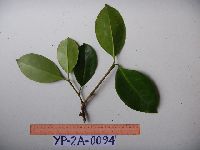 951544[1297698]Weiblen, G.D. YP2A00942010-10-05 Papua New Guinea, Morobe, Yawan Village, -6.162617 146.841967, 1777m |
MIN:Plants | 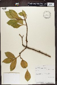 Garcinia buchananii """""Zemagho" 499306[1370091]Bingham, M. G. 85671992-10-09 Zambia, Southern Region, Mazabuka District, Mubuyu Farm, -16 28.116667, 1000m |
MIN:Plants | 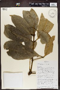 499668[1370092]Sennen Randrianasolo 1422000-01-26 Madagascar, Antanandava, a 1.5 km d'Ankosy, en dehors du Parc natinoal de Zahamena, -17.480833 48.738611 |
MIN:Plants | 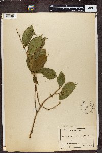 Garcinia punctata """""(Harms) Lowry" 154404[1370093]Staudt 5091896-00-00 Cameroon |
MIN:Plants | 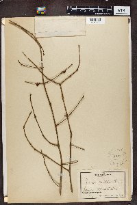 Garcinia punctata """""(Harms) Lowry" 154402[1370094]Staudt 4461896-00-00 Cameroon, Johann, Allrechtshohe Urwaldgebiet. |
MIN:Plants |  Garcinia punctata """""(Harms) Lowry" 154403[1370095]Foh. Braun 30 Cameroon |
MIN:Plants |  499656[1370096]S. Randrianasolo 2122001-05-03 Madagascar, Fiv. Ambatondrazaka, Commune Manakambahiny-Est, Fkt. Sahamalaza. Lahindrotra, a 18 km au Sud-Est d'Anosivola, le long de la riviere d'Onibe., -17.755 48.707778, 900m |
MIN:Plants |  Garcinia ledermannii Lauterbach 969972[1371545]Weiblen, G. D. & Binatang Research Center NP1A02871931-05-28 Papua New Guinea, Madang, Numba, -5.7222 145.2714, 1200m |
1
Page 1, records 1-40 of 40
Google Map
Google Maps is a web mapping service provided by Google that features a map that users can pan (by dragging the mouse) and zoom (by using the mouse wheel). Collection points are displayed as colored markers that when clicked on, displays the full information for that collection. When multiple species are queried (separated by semi-colons), different colored markers denote each individual species.