University of Minnesota
http://www.umn.edu/
612-625-5000
http://www.umn.edu/
612-625-5000
Minnesota Biodiversity Atlas
Bell Museum
Dataset: MIN-Plants
Taxa: Hymenophyllum
Search Criteria: excluding cultivated/captive occurrences
Bell Museum plants | |
 MIN:Plants |  Hymenophyllum obtusum Hooker & Arnott 272922[1339101]Degener, O. H1651922-12-15 United States, Hawaii, Hawaii, Near Kilauea-Iki crater, Hawaii.;Hawaii Volcanoes National Park;;;, 19.4 -155.3 |
MIN:Plants |  Hymenophyllum lanceolatum Hooker & Arnott 272923[1339090]Degener, O. H1661922-12-15 United States, Hawaii, Hawaii, Byron Path, Kilauea, Hawaii.;Hawaii Volcanoes National Park;;;, 19.4 -155.3 |
MIN:Plants |  Hymenophyllum epiphyticum J.W. Moore 620423[1097014]Moore, John W. 5501927-01-20 French Polynesia, Society Islands, Raiatea, Mountain to the north side of Faaroa Bay., -17.653639 -149.468506, 400m |
MIN:Plants |  Hymenophyllum productoides J.W. Moore 620125[1097015]Moore, John W. 6601927-03-05 French Polynesia, Society Islands, Raiatea, South end fo Opoa Mountain, -17.653639 -149.468506, 300m |
MIN:Plants | 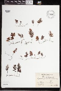 Hymenophyllum barbatum (Bosch) Baker 954297[1294609]Koyama, S. 581951-09-02 Japan, Mt. Hieizan Pref. Kyoto, 34.984613 135.758343 |
MIN:Plants | 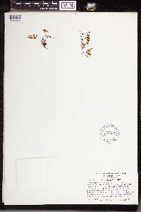 Hymenophyllum tunbrigense (L.) Sm. 608297[1338986]Leonard, S.W. 1968-10-12 United States, South Carolina, Pickens, Eastatoe River, about 1.5 miles from the end of County Route 92 |
MIN:Plants | 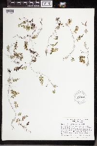 Hymenophyllum tunbrigense (L.) Sm. 621281[1338987]Leonard, S.W. 1970-06-22 United States, South Carolina, Pickens, Eastatoe River Gorge, about 1.5 miles N of County Route 92. |
MIN:Plants | 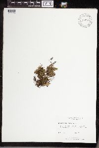 Hymenophyllum tunbrigense (L.) Sm. 817507[1338988]Rayner, D.A. 1980-08-00 United States, South Carolina, Pickens, along Rocky Bottom Creek, Eastatoe Gap |
MIN:Plants |  50397[1338989]Bang, A. Miguel 1892-04-00 Bolivia, Guanai-Tipuani |
MIN:Plants |  Hymenophyllum andinum Bosch 481057[1338990]Uribe, Lorenzo 1939-00-00 Colombia, Mountains of Santandercito, Cundinamarca, 1900m |
MIN:Plants |  50403[1338991]Bang, A. Miguel 1890-00-00 Bolivia, Yungas |
MIN:Plants |  50404[1338992]Bang, A. Miguel 1891-11-00 Bolivia, Songo |
MIN:Plants |  Hymenophyllum hirsutum (L.) Sw. 281192[1338993]Durand, E.J. 1876-00-00 Brazil, Rio |
MIN:Plants |  Hymenophyllum plumosum Kaulf. 942566[1338994]Fay, Alice 35151992-07-02 Ecuador, Tungurahua, Banos, 5 km east of Banos in the area of the Agoyan waterfall, -1.391667 -78.375, 1650m |
MIN:Plants |  50422[1338995]Bang, A. Miguel 1890-11-00 Bolivia, Songo |
MIN:Plants |  Hymenophyllum protrusum Hook. 50425[1338996]Bang, A. Miguel 1890-00-00 Bolivia, Yungas |
MIN:Plants |  Hymenophyllum speciosum Bosch 447707[1338997]Fay, Alice 38371992-08-04 Ecuador, Napo, Quijos, trail through pastures and into jungle, S from Quijos, just E of Baeza, -0.475 -77.891667, 2100m |
MIN:Plants |  271152[1338998]Tilden, J.E. 1913-01-00 New Zealand |
MIN:Plants |  349415[1338999]Topping, D.L. 1909-01-23 Philippines, Luzon, Pauai, Benguet |
MIN:Plants |  616993[1339000]Perrin, Mrs. 1934-11-00 Australia, Tasmania, Lowhead, Launceston. Western Tier, Great Lakes Road |
MIN:Plants |  701921[1339001]Taylor, John 1974-12-26 Costa Rica, slopes of Cerro Zurqui above the Rio Para Blanco, 1600m |
MIN:Plants |  701917[1339002]Taylor, John 1974-12-27 Costa Rica, near the Rio Las Vueltas about 12 km, NE of Heredia |
MIN:Plants |  701928[1339003]Taylor, John 1974-12-27 Costa Rica, near the Rio Las Vueltas about 12 km. NE of Heredia |
MIN:Plants |  701944[1339004]Taylor, John 1974-12-27 Costa Rica, near the Rio Las Vueltas about 12 km. NE of Heredia |
MIN:Plants |  Hymenophyllum abruptum Hook. 50398[1339005]Clute, Willard N. 1900-02-06 Jamaica, Morce's Gap, 1524m |
MIN:Plants |  Hymenophyllum asplenioides (Sw.) Sw. 281193[1339006]York, H.H. 1910-05-23 Jamaica, John Crow Peak |
MIN:Plants |  Hymenophyllum asplenioides (Sw.) Sw. 50399[1339007]Clute, Willard N. 1900-02-08 Jamaica, John Crow Peak, 1707m |
MIN:Plants |  279254[1339008]Orcutt, C.R. Jamaica, Abbey Green |
MIN:Plants |  426520[1339009] Honduras |
MIN:Plants |  50402[1339010]Pringle, C.G. 1899-04-18 Mexico, Vera Cruz, near Jalapa, 1219m |
MIN:Plants |  592994[1339011]Hess, W.E. 1914-01-12 Puerto Rico, Maricao |
MIN:Plants |  521389[1339012]Shreve, Forrest 1906-02-07 Jamaica, Morce's Gap |
MIN:Plants |  Hymenophyllum clavatum (Sw.) Sw. 50406[1339013]Clute, Willard N. 1900-02-06 Jamaica, Morce's Gap, 1524m |
MIN:Plants |  589504[1339014]Spross, B.C. 1331964-08-04 Guatemala, Quiche, about one mile northwest of Nebaj, 1829m |
MIN:Plants |  50410[1339015]Pollard, Charles L. 1902-01-30 Cuba, Santiago, Slopes and summit of El Yunque near Baracoa, 305 - 610m |
MIN:Plants |  521490[1339016]Shreve, Forrest 1906-02-07 Jamaica, Morce's Gap |
MIN:Plants |  Hymenophyllum hirsutum (L.) Sw. 50411[1339017]Pringle, C.G. 1895-01-25 Mexico, Vera Cruz, hills above Orizaba, 1311m |
MIN:Plants |  Hymenophyllum hirsutum (L.) Sw. 521492[1339018]Shreve, Forrest 1906-02-12 Jamaica, Monkey Island, 1768m |
MIN:Plants |  Hymenophyllum hirsutum (L.) Sw. 521556[1339019]Shreve, Forrest 1906-04-00 Jamaica, Morce's Gap |
MIN:Plants |  Hymenophyllum hirsutum (L.) Sw. 50412[1339020]Clute, Willard N. 1900-02-12 Jamaica, Morce's Gap, 1524m |
MIN:Plants |  Hymenophyllum laciniosum Christ 405848[1339021]Knight, Wm. 1958-02-06 Costa Rica, Pacayao |
MIN:Plants |  Hymenophyllum lanceolatum Hooker & Arnott 50413[1339022]Clute, Willard N. 1900-02-15 Jamaica, Morce's Gap |
MIN:Plants |  Hymenophyllum lanceolatum Hooker & Arnott 521402[1339023]Shreve, Forrest 1906-01-00 Jamaica, Morce's Gap |
MIN:Plants |  50417[1339024]Smith, Jared G. 1892-00-00 Mexico, Mozorongo |
MIN:Plants |  521491[1339025]Shreve, Forrest 1906-05-14 Jamaica, Blue Mountain Peak |
MIN:Plants |  50401[1339026]Clute, Willard N. 1900-02-20 Jamaica, Morce's Gap |
MIN:Plants |  50424[1339027]Clute, Willard N. 1900-02-28 Jamaica, Above Moore Town, 457m |
MIN:Plants |  220433[1339028]York, H.H. 1910-01-02 Jamaica, Vinegar Hill Trail |
MIN:Plants |  522001[1339029]Shreve, Forrest 1906-04-02 Jamaica, Morce's Gap |
MIN:Plants |  Hymenophyllum sanguinolentum (Forst.) Sw. 50429[1339030]Clute, Willard N. 1900-02-20 Jamaica, Morce's Gap, 1524m |
MIN:Plants |  Hymenophyllum sericeum (Sw.) Sw. 521814[1339031]Shreve, Forrest 1906-02-07 Jamaica, Morce's Gap |
MIN:Plants |  Hymenophyllum sericeum (Sw.) Sw. 50432[1339032] 1906-03-00 Jamaica, Morce's Gap, 1524m |
MIN:Plants |  Hymenophyllum sericeum (Sw.) Sw. 50433[1339033]Clute, Willard N. 1900-02-15 Jamaica, Morce's Gap, 1524m |
MIN:Plants |  Hymenophyllum sieberi Bosch 500323[1339034]Tucker, John M. 1942-03-15 El Salvador, Chalatenango, E slope of Los Esesmiles, 14.35 -89.15 |
MIN:Plants |  Hymenophyllum tunbrigense (L.) Sm. 521815[1339035]Shreve, Forrest 1906-01-27 Jamaica, Morce's Gap |
MIN:Plants |  Hymenophyllum peltatum (Poir.) Desv. 343503[1339036]Lillefosse, T. 1916-07-17 Norway, Nordholland: Herlo, Gigaren. Lille Juro |
MIN:Plants |  Hymenophyllum peltatum (Poir.) Desv. 343502[1339037]Lillefosse, T. 1912-07-07 Norway, Nordhardland: Herlo, Agno |
MIN:Plants |  Hymenophyllum peltatum (Poir.) Desv. 50419[1339038]Jorgensen, E. 1897-10-30 Norway, Bergen |
MIN:Plants |  Hymenophyllum peltatum (Poir.) Desv. 355691[1339039]Hartzechpsteufeld, J. 1897-07-23 Faroe Islands, Insula Ludero |
MIN:Plants |  Hymenophyllum peltatum (Poir.) Desv. 50421[1339040]Greve, Jan 1899-09-17 Norway, Bergen |
MIN:Plants |  Hymenophyllum peltatum (Poir.) Desv. 50420[1339041]Bagenholm, Gosta 1894-07-00 Norway, Ryfylke |
MIN:Plants |  50436[1339042]Waterfall, Wm. Booth 1876-08-00 Denmark |
MIN:Plants |  50437[1339043] 1885-07-30 France, Gallia, Cherbourg |
MIN:Plants |  50435[1339044]Restessi 1895-00-00 France, Martain |
MIN:Plants |  Hymenophyllum wilsonii Hook. 50440[1339045]Edwards, Mary 1869-08-17 [illegible] |
MIN:Plants |  Hymenophyllum wilsonii Hook. 50441[1339046]Colgan, Nathan 1898-09-13 Ireland, Crock-na-guile Mountain, 400m |
MIN:Plants |  Hymenophyllum wilsonii Hook. 50439[1339047]Lyon, H.L. 1902-06-16 United Kingdom, Inversnaid, Scollard |
MIN:Plants |  50405[1339048]Hildebrandt 1881-03-04 Madagascar, Aukafina: Urwald |
MIN:Plants |  Hymenophyllum obtusum Hooker & Arnott 50418[1339049] 0000-09-00 South Africa, Johnlaris, 762m |
MIN:Plants |  50434[1339050]Wood, J. Medley South Africa, Noodsberg, 762m |
MIN:Plants |  Hymenophyllum australe Willd. 349221[1339051]Topping, D.L. 1909-01-28 Philippines, Luzon, Pauai, Benquet |
MIN:Plants |  Hymenophyllum barbatum (Bosch) Baker 50400[1339052]Stanford, Arthur W. 1994-10-00 Japan, Kyoto |
MIN:Plants |  Hymenophyllum bivalve (Forst.) Sw. 617163[1339053]Philson, P.J. 1935-02-17 New Zealand, Stewart Island, 1 mile W of Oban |
MIN:Plants |  Hymenophyllum bivalve (Forst.) Sw. 617166[1339054]Philson, P.J. 1935-02-17 New Zealand, Stewart Island, 1 mile W of Oban |
MIN:Plants |  Hymenophyllum blumeanum Spreng. 620063[1339055]Moore, John W. 801926-09-16 French Polynesia, Raiatea, along east path to Mt. Temehani, -16.818444 -151.427227, 350m |
MIN:Plants |  Hymenophyllum demissum (Forst.) Sw. 617191[1339056]Philson, P.J. 1935-01-16 New Zealand, Bay of Islands, 2.5 miles NE of Matauhui Bay, 30m |
MIN:Plants |  Hymenophyllum demissum (Forst.) Sw. 50408[1339057]Armstrong, C.C. 1888-00-00 New Zealand, vicinity of Dunedin |
MIN:Plants |  Hymenophyllum demissum (Forst.) Sw. 50407[1339058]Cockayne, L. 1901-00-00 Australia, Chatham Island |
MIN:Plants |  Hymenophyllum demissum (Forst.) Sw. 270641[1339059]Leland, B. 1910-02-00 New Zealand, Te Aroha |
MIN:Plants |  Hymenophyllum demissum (Forst.) Sw. 270743[1339060]Leland, B. 1910-02-00 New Zealand, Bluff |
MIN:Plants |  Hymenophyllum demissum (Forst.) Sw. 270277[1339061]Leland, B. 1909-11-00 New Zealand, Rotorua |
MIN:Plants |  Hymenophyllum dilatatum (Forst.) Sw. 270744[1339062]Leland, B. 1910-02-00 New Zealand, Bluff |
MIN:Plants |  Hymenophyllum dilatatum (Forst.) Sw. 270754[1339063]Leland, B. 1910-02-00 New Zealand, Bluff |
MIN:Plants |  Hymenophyllum dilatatum (Forst.) Sw. 239986[1339064]Grant, Martin L. 1930-09-21 French Polynesia, Tahiti, Papenoo District, Orofena |
MIN:Plants |  Hymenophyllum dilatatum (Forst.) Sw. 270295[1339065]Leland, B. 1909-11-00 New Zealand, Rotorua |
MIN:Plants |  Hymenophyllum dilatatum (Forst.) Sw. 289985[1339066]Grant, Martin L. 1930-11-15 French Polynesia, Tahiti, Hitiaa District, Puunui, 363m |
MIN:Plants |  Hymenophyllum dilatatum (Forst.) Sw. 289984[1339067]Grant, Martin L. 1931-01-03 French Polynesia, Borabora, Tevaitapu District, Tarapaia, 597m |
MIN:Plants |  Hymenophyllum dilatatum (Forst.) Sw. 289983[1339068]Grant, Martin L. 1931-02-07 French Polynesia, Tahiti, Maeva District, Matoereere, 530m |
MIN:Plants |  Hymenophyllum dilatatum (Forst.) Sw. 616959[1339069]Philson, P.J. 1935-01-26 New Zealand, Bay of Islands. 12 miles from Russell on Whangarei road., 61m |
MIN:Plants |  Hymenophyllum dilatatum (Forst.) Sw. 289987[1339070]Grant, Martin L. 1930-06-04 French Polynesia, Tahiti, Mahina District, Aorai, 1241m |
MIN:Plants |  Hymenophyllum dilatatum (Forst.) Sw. 289988[1339071]Grant, Martin L. 1930-05-13 French Polynesia, Tahiti, Pare District, Diadem, 983m |
MIN:Plants |  Hymenophyllum dilatatum (Forst.) Sw. 617153[1339072]Doore, L.A. 1935-02-18 New Zealand, Stewart Island, 1 mile W of Oban |
MIN:Plants |  Hymenophyllum dilatatum (Forst.) Sw. 50409[1339073]Cockayne, L. Australia, Chatham Island |
MIN:Plants |  617145[1339074]Philson, P.J. 1935-02-15 New Zealand, Stewart Island, 1 mile NW of Oban on "Bush road" to Horseshoe Bay. |
MIN:Plants |  Hymenophyllum formosum Brack. 289989[1339075]Grant, Martin L. 1931-02-07 French Polynesia, Huahine, Maeva District, Matoereere, 530m |
MIN:Plants |  Hymenophyllum flabellatum Labill. 936614[1339076]Jones, L.M. 1934-12-00 Australia, Tasmania. Lowhead, Launceston |
MIN:Plants |  Hymenophyllum flabellatum Labill. 289991[1339077]Grant, Martin L. 1930-11-05 French Polynesia, Tahiti, Mahina District, Ahonu, 1082m |
MIN:Plants |  Hymenophyllum flabellatum Labill. 270779[1339078]Leland, B. 1910-02-00 New Zealand, Stewart Island |
MIN:Plants |  Hymenophyllum flabellatum Labill. 616957[1339079]Philson, P.J. 1935-01-26 New Zealand, Bay of Islands. 12 miles from Russell on Whangarei road., 61m |
MIN:Plants |  Hymenophyllum flabellatum Labill. 617165[1339080]Philson, P.J. 1935-02-17 New Zealand, Stewart Island, 1 mile W of Oban |
Google Map
Google Maps is a web mapping service provided by Google that features a map that users can pan (by dragging the mouse) and zoom (by using the mouse wheel). Collection points are displayed as colored markers that when clicked on, displays the full information for that collection. When multiple species are queried (separated by semi-colons), different colored markers denote each individual species.