University of Minnesota
http://www.umn.edu/
612-625-5000
http://www.umn.edu/
612-625-5000
Minnesota Biodiversity Atlas
Bell Museum
Dataset: MIN-Plants
Taxa: Ipomopsis
Search Criteria: excluding cultivated/captive occurrences
1
Page 1, records 1-24 of 24
Bell Museum plants | |
 MIN:Plants | Ipomopsis aggregata subsp. formosissima (Greene) Wherry 237781[]Congdon, J. s.n.1891-07-25 United States, California, Mariposa, Glacier Point Turnpike;Yosemite National Park;;;, 37.73083 -119.57278 |
MIN:Plants | Ipomopsis aggregata subsp. attenuata (A. Gray) V.E. Grant & A.D. Grant 680232[]Bright, R. 75-551975-09-19 United States, Idaho, Bear Lake, Bear Lake Co, ridge south of Copenhagen Basin, 20 mi NE of Preston., 2621m |
MIN:Plants | Ipomopsis aggregata subsp. bridgesii (A. Gray) V.E. Grant & A.D. Grant 237534[]Congdon, J. s.n.1889-08-26 United States, California, Mariposa, Glacier Point, Mariposa County;Yosemite National Park;;;, 37.73083 -119.57278 |
MIN:Plants | Ipomopsis aggregata subsp. formosissima (Greene) Wherry 237422[]Congdon, J. s.n.1889-07-00 United States, California, Mariposa, Cliffs above Crescent Lake, Mariposa County;Yosemite National Park |
MIN:Plants | Ipomopsis aggregata subsp. formosissima (Greene) Wherry 237727[]Congdon, J. s.n.1899-08-19 United States, California, Madera, Old Norris Store, east of Minarets, Madera County;Yosemite National Park |
MIN:Plants | Ipomopsis aggregata subsp. bridgesii (A. Gray) V.E. Grant & A.D. Grant 237526[]Congdon, J. s.n.1890-08-13 United States, California, Mariposa, Turner Trail, south of Yosemite, Mariposa County;Yosemite National Park |
MIN:Plants | Ipomopsis aggregata subsp. attenuata (A. Gray) V.E. Grant & A.D. Grant 510816[]Bright, R. 72-811972-00-00 United States, Idaho, Franklin, [no further data] |
MIN:Plants | Ipomopsis aggregata (Pursh) V.E. Grant 499684[]Went, F. s.n.1966-08-00 United States, California, Alpine, Carson Pass, Alpine Co. |
MIN:Plants | 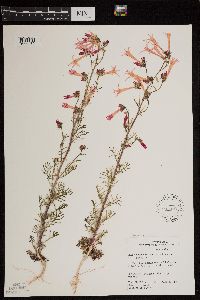 Ipomopsis aggregata subsp. aggregata (Pursh) V.E. Grant 597062[1299480]Holmgren, Noel; et al. 17971965-06-04 United States, Utah, Uintah, Uintah Co.: 1 mile west of Rainbow. T.11 S, R.24 E.;;011S;24E;00, 1829m |
MIN:Plants | Ipomopsis congesta (Hooker) V.E. Grant 281395[]Went, F. s.n.1966-08-00 United States, California, Alpine, Carson Pass, Alpine Co. |
MIN:Plants | 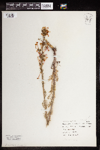 Ipomopsis aggregata (Pursh) V.E. Grant 964159[1375128] United States, Wyoming |
MIN:Plants | 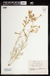 Ipomopsis aggregata (Pursh) V.E. Grant 964160[1375129] United States, Colorado |
MIN:Plants | 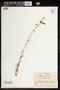 Ipomopsis aggregata (Pursh) V.E. Grant 964161[1375130] United States, Colorado |
MIN:Plants | 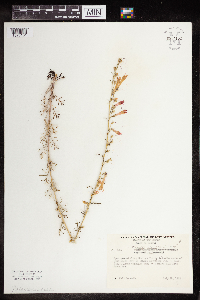 Ipomopsis aggregata (Pursh) V.E. Grant 964162[1375131] United States, New Mexico |
MIN:Plants | 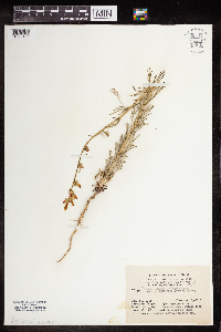 Ipomopsis aggregata (Pursh) V.E. Grant 964163[1375132] United States, Colorado |
MIN:Plants | 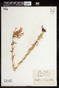 Ipomopsis aggregata (Pursh) V.E. Grant 964164[1375133] United States, Colorado |
MIN:Plants | 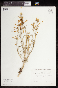 Ipomopsis aggregata (Pursh) V.E. Grant 964165[1375134] United States, Idaho |
MIN:Plants | 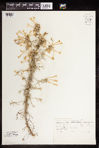 Ipomopsis aggregata (Pursh) V.E. Grant 964166[1375135] United States, Colorado |
MIN:Plants | 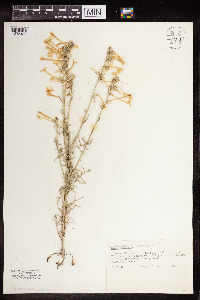 Ipomopsis aggregata (Pursh) V.E. Grant 964167[1375136] United States, Colorado |
MIN:Plants | 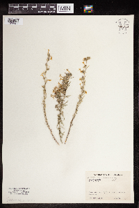 Ipomopsis pumila (Nutt.) V.E. Grant 964170[1375139] United States, Arizona |
MIN:Plants | Ipomopsis aggregata (Pursh) V.E. Grant []Terry, S. GW13482002-07-29 United States, Colorado, Gunnison, Kebler Pass Road near Marcellina Mountain, Gunnison National Forest, 38.910056 -107.240528, 2590m |
MIN:Plants | Ipomopsis aggregata (Pursh) V.E. Grant []Graves, B. GW25552005-06-29 United States, Colorado, Gunnison, Kebler Pass Road near Marcellina Mountain, Gunnison National Forest, 38.910056 -107.240528, 2590m |
MIN:Plants | Ipomopsis aggregata (Pursh) V.E. Grant []Boyd, M. GW26402005-06-29 United States, Colorado, Gunnison, Kebler Pass Road near Marcellina Mountain, Gunnison National Forest, 38.910056 -107.240528, 2590m |
MIN:Plants | Ipomopsis aggregata (Pursh) V.E. Grant []Weiblen, G. D. GW13022001-07-30 United States, Colorado, Gunnison, 1.67 km W of cemetary on Kebler Pass Road, 38.833333 -107.083333, 2987m |
1
Page 1, records 1-24 of 24
Google Map
Google Maps is a web mapping service provided by Google that features a map that users can pan (by dragging the mouse) and zoom (by using the mouse wheel). Collection points are displayed as colored markers that when clicked on, displays the full information for that collection. When multiple species are queried (separated by semi-colons), different colored markers denote each individual species.