University of Minnesota
http://www.umn.edu/
612-625-5000
http://www.umn.edu/
612-625-5000
Minnesota Biodiversity Atlas
Bell Museum
Dataset: MIN-Plants
Taxa: Ivesia
Search Criteria: excluding cultivated/captive occurrences
1
Page 1, records 1-12 of 12
Bell Museum plants | |
 MIN:Plants | 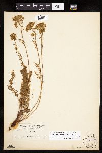 Ivesia gordonii var. wasatchensis N.H.Holmgren ex Ertter & Reveal 258600[1027930]Nelson, Aven; et al. 63381899-08-06 United States, Wyoming, Park, Yellowstone National Park...Yellowstone Lake;Yellowstone National Park;;;, 44.41024 -110.42084 |
MIN:Plants | Ivesia gordonii (Hooker) Torrey & A. Gray 510530[]Bright, R. 73-2961973-08-28 United States, Idaho, Franklin, [no further data] |
MIN:Plants | 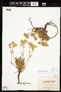 Ivesia gordonii var. gordonii (Hooker) Torrey & A. Gray 128300[1027929]Nelson, Aven; et al. 62801899-08-03 United States, Wyoming, Park, Yellowstone National Park...Lone Star Geyser;Yellowstone National Park;;;, 44.55916 -110.54993 |
MIN:Plants | 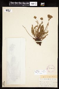 Ivesia gordonii var. gordonii (Hooker) Torrey & A. Gray 279423[1027926]Hawkins, P. 511a1922-07-02 United States, Wyoming, Park, Yellowstone National Park...Atlantic side of Divide;Yellowstone National Park;;;, 44.59829 -110.57739 |
MIN:Plants | 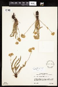 Ivesia gordonii var. gordonii (Hooker) Torrey & A. Gray 539724[1027928]Weber, W. 96271956-06-03 United States, Utah, Uintah, Uintah Co. ...just back of Doug Chew cabin, T. 4S, R. 25E, Sec. 17, Dinosaur National Monument;Dinosaur National Monument;004S;25E;17, 40.47236 -109.1258, 2286m |
MIN:Plants | 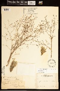 Ivesia santolinoides A. Gray 237887[1284275]Congdon, J. s.n.1889-08-22 United States, California, Mariposa, Upper Chilnualna Creek, Mariposa County;Yosemite National Park |
MIN:Plants | 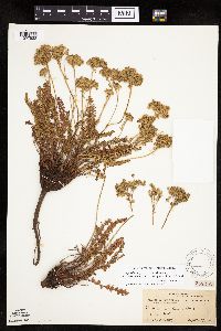 Ivesia gordonii var. wasatchensis N.H.Holmgren ex Ertter & Reveal 258316[1027932]Mearns, E. 41981902-09-17 United States, Wyoming, Park, Yellowstone National Park...Corkscrew Hill;Yellowstone National Park;;;, 44.55916 -110.57739 |
MIN:Plants | 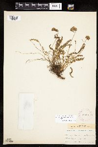 Ivesia gordonii var. gordonii (Hooker) Torrey & A. Gray 279422[1027927]Hawkins, P. 511a1922-07-02 United States, Wyoming, Park, Yellowstone National Park...Atlantic side of Divide;Yellowstone National Park;;;, 44.59829 -110.57739 |
MIN:Plants | 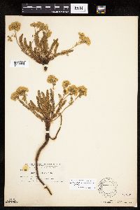 Ivesia gordonii var. gordonii (Hooker) Torrey & A. Gray 258599[1027925]Nelson, Aven; et al. 62801899-08-03 United States, Wyoming, Park, Yellowstone National Park...Lone Star Geyser;Yellowstone National Park;;;, 44.55916 -110.54993 |
MIN:Plants | 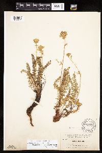 Ivesia gordonii var. wasatchensis N.H.Holmgren ex Ertter & Reveal 128297[1027931]Nelson, Aven; et al. 63381899-08-06 United States, Wyoming, Park, Yellowstone National Park...Yellowstone Lake;Yellowstone National Park;;;, 44.41024 -110.42084 |
MIN:Plants | 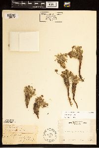 Ivesia muirii A. Gray 238717[1284274]Congdon, J. W. s.n.1890-08-20 United States, California, Mariposa, Mt. Hoffman [Yosemite National Park] |
MIN:Plants | 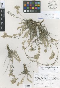 Ivesia rhypara Ertter & Reveal 751144[1001463]Reveal, J.L. 38941975-07-13 United States, Oregon, Malheur, Leslie Gulch, 0.1 mile down the road from the entrance along the road toward Lake Owyhee |
1
Page 1, records 1-12 of 12
Google Map
Google Maps is a web mapping service provided by Google that features a map that users can pan (by dragging the mouse) and zoom (by using the mouse wheel). Collection points are displayed as colored markers that when clicked on, displays the full information for that collection. When multiple species are queried (separated by semi-colons), different colored markers denote each individual species.