University of Minnesota
http://www.umn.edu/
612-625-5000
http://www.umn.edu/
612-625-5000
Minnesota Biodiversity Atlas
Bell Museum
Dataset: MIN-Plants
Taxa: Larrea
Search Criteria: excluding cultivated/captive occurrences
1
Page 1, records 1-12 of 12
Bell Museum plants | |
 MIN:Plants | 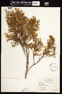 Larrea tridentata (de Candolle) Coville 570220[1056985]Demaree, Delzie 409511959-05-29 United States, Arizona, Mohave, Mohave County ... P.O. Kingman, 1097m |
MIN:Plants | 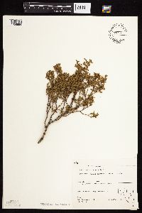 Larrea tridentata (de Candolle) Coville 794786[1056984]Schaaf, J. 3161982-08-30 United States, Nevada, Esmeralda, Esmerelda Co. ... So. of Goldfield, 2134m |
MIN:Plants | Larrea divaricata Cav. 755950[]Davis, Owen AZ76-101976-10-08 United States, Arizona, Maricopa, ca. 20 miles west of Tempe. Salt River. |
MIN:Plants | Larrea tridentata var. tridentata (de Candolle) Coville 499402[]Went, F. s.n.1970-08-00 Chile, Amaicha [?] |
MIN:Plants | Larrea tridentata (de Candolle) Coville 145980[]Coville, Frederick V. 4871891-03-24 United States, California, Inyo, Furnace Creek ranch, Death Valley [Death Valley National Park] |
MIN:Plants | Larrea tridentata (de Candolle) Coville 385034[]Mueller, C. H. s.n.1932-07-12 United States, Texas, Brewster, Shearring pens, Chisos Mts. [Big Bend National Park] |
MIN:Plants | Larrea tridentata (de Candolle) Coville 289220[]Jones, Marcus E. s.n.1907-04-08 United States, California, Inyo, Funeral Mountains, Death Valley [Death Valley National Park], 305m |
MIN:Plants | Larrea tridentata (de Candolle) Coville 289217[]Jones, Marcus E. s.n.1897-05-03 United States, California, Inyo, Panamint Canyon [Death Valley National Park], 610m |
MIN:Plants | Larrea tridentata (de Candolle) Coville 949221[]Schneider, Heather E. 12-20130419-1V2013-04-19 United States, California, Riverside, Joshua Tree National Park, approx. 48 miles east of Palm Springs, CA, 33.84693 -115.72116, 660m |
MIN:Plants | Larrea tridentata (de Candolle) Coville 949222[]Schneider, Heather E. 10-20130419-1V2013-04-19 United States, California, San Bernardino, Joshua Tree National Park, approx. 22 miles E of Yucca Valley, CA, 34.07247 -116.03523, 898m |
MIN:Plants | 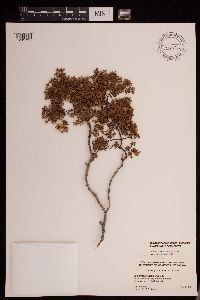 Larrea tridentata (de Candolle) Coville 479150[1291731]Roberts, M.E. s.n.1932-04-00 United States, California, Riverside, Desert in the vicinity of Palm Springs. |
MIN:Plants | 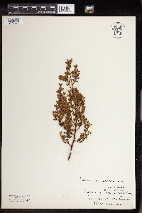 961944[1340522] United States, California |
1
Page 1, records 1-12 of 12
Google Map
Google Maps is a web mapping service provided by Google that features a map that users can pan (by dragging the mouse) and zoom (by using the mouse wheel). Collection points are displayed as colored markers that when clicked on, displays the full information for that collection. When multiple species are queried (separated by semi-colons), different colored markers denote each individual species.