University of Minnesota
http://www.umn.edu/
612-625-5000
http://www.umn.edu/
612-625-5000
Minnesota Biodiversity Atlas
Bell Museum
Dataset: MIN-Plants
Taxa: Lathyrus
Search Criteria: excluding cultivated/captive occurrences
Bell Museum plants | |
 MIN:Plants |  540008[1077186]Tester, John s.n.1957-06-24 United States, Minnesota, Mahnomen, Mahnomen County...Waubun prairie, 3-4 miles w. and 1 mile s. of Waubun. Sect. 33, T. 143N, R. 42W.;Waubun Prairie Wildlife Management Area / White Earth Indian Reservation;143N;42W;33, 47.1589041 -96.0074302 |
MIN:Plants |  Lathyrus venosus var. intonsus Butters & H. St. John 492689[1077434]Wheeler, Gerald 159321997-06-06 United States, Minnesota, Brown, Brown County ... Ca. 15 mi. NW of Sleepy Eye; 0.4 mi NE of Rte. 10; Morgan Sportsmand Club Recreation Area ... SW1/4 NE1/4 SW1/4 Sec. 19 T112N R33W. 112N 33W 19, 44.4897701 -94.8570391 |
MIN:Plants |  Lathyrus lanszwertii var. aridus (Piper) Jepson 236143[1076869]Congdon, J. s.n.1897-06-08 United States, California, Tuolumne, Tioga Road near Crockers, Tuolumne Co.;Yosemite National Park |
MIN:Plants |  Lathyrus venosus var. intonsus Butters & H. St. John 432187[1077455]Gerdes, Lynden; et al. 34841999-06-23 United States, Minnesota, Cook, Superior National Forest. T65N R02W S19SENE. Cook County...Superior National Forest. Northeast corner of the most southeastern bay of Gunflint Lake.. 065N 02W 19, 48.0985658 -90.241796 |
MIN:Plants |  Lathyrus venosus var. intonsus Butters & H. St. John 907115[1077436]Smith, Welby 285332000-06-15 United States, Minnesota, Otter Tail, Otter Tail County...Almora State Wildlife Management Area about 0.75 mi W of Almora...T132N R37W SW1/4 of NE1/4 of Sec18;Almora Wildlife Management Area;132N;37W;18, 46.2466667 -95.3786111 |
MIN:Plants |  482313[1077298]Bockenstedt, P. 010022001-07-05 United States, Minnesota, Carver, N. edge, NE1/4, Sec. 13, T115N R24W, Carver County; along Highway 212 in south ditch on either side of old homestead/field entrance.. 115N 24W 13, 44.7689989 -93.6529969 |
MIN:Plants |  Lathyrus venosus var. intonsus Butters & H. St. John 478137[1077489]Wheeler, Gerald 189781998-06-09 United States, Minnesota, Carver, Carver County ... Ca. 2.5 mi. E of East Union on Rte. 50, S of raod ... E1/2 NE1/4 Sec. 6 T114N R23W;;114N;23W;6, 44.710544 -93.6337396 |
MIN:Plants |  Lathyrus venosus var. intonsus Butters & H. St. John 552961[1077435]Tester, John s.n.1958-07-02 United States, Minnesota, Mahnomen, Mahnomen County...Waubun prairie, 3-4 miles w. and 1 mile s. of Waubun. Sect. 33, T. 143N, R. 42W.;Waubun Prairie Wildlife Management Area / White Earth Indian Reservation;143N;42W;33, 47.1589041 -96.0074302 |
MIN:Plants | 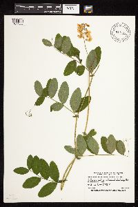 Lathyrus venosus var. intonsus Butters & H. St. John 914666[1077509]Smith, Welby 226271993-06-29 United States, Minnesota, Swift, Swift County...Lake Monson State Park, about 17 miles northwest of Wilmar [sic]...T 121N R 37W SW1/4 of NW1/4 of Sec 1;Monson Lake State Park;121N;37W;01, 45.3236111 -95.2688889 |
MIN:Plants | 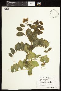 Lathyrus maritimus var. glaber (Seringe) Eames 431794[1076878]Dahle, R. 980201998-06-07 United States, Minnesota, Lake of the Woods, Pine & Curry Islands Scientific Natural Area. Lake of the Woods County ... About twelve miles northwest of Baudette where the Rainy River meets Lake of the Woods. In the Sand [sic - should be Pine] and Curry Island Scientific and Natural Area ... T162 R32 NW1/4 of SW1/4 of Sec 11. 162N 32W 11, 48.8624992 -94.7358322 |
MIN:Plants | 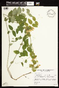 Lathyrus ochroleucus Hooker 508062[1076931]Gerdes, Lynden 25651998-06-01 United States, Minnesota, Cook, Superior National Forest. T65N R04W S26SESWNE. Cook County ... Superior National Forest, approx. .25 miiles north of the Gunflint Trail (Cty. 12) / FR 1347 junction, then west off FR 1347 to area of bedrock outcrop.. 065N 04W 26 |
MIN:Plants | 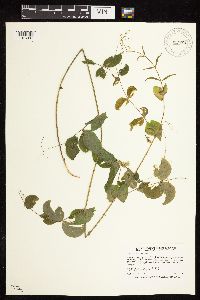 Lathyrus ochroleucus Hooker 912870[1076991]Smith, Welby 241921994-05-31 United States, Minnesota, Koochiching, Franz Jevne State Park. Koochiching County...Franz Jevne State Park. In the Rainy River Valley, about 2 miles northeast of Birchdale... T 160N R 27W SW1/4 of SW1/4 of Sec 26. 160N 27W 26, 48.6427778 -94.0783333 |
MIN:Plants | 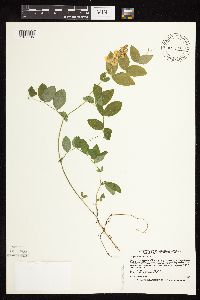 Lathyrus ochroleucus Hooker 431874[1077105]Smith, Welby 166921990-05-29 United States, Minnesota, Dodge, Dodge County..About 3 miles northwest of Byron. On a S-facing slope overlooking the South Branch Middle Fork Zumbro River...T 107N R 16W NE1/4 of SW1/4 of Sec 13. 107N 16W 13, 44.0708351 -92.6858368 |
MIN:Plants | 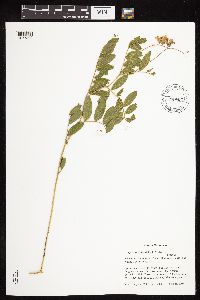 Lathyrus venosus var. intonsus Butters & H. St. John 431985[1077309]Cully, Anne; et al. s.n.1998-06-21 United States, Minnesota, Cottonwood, Cottonwood County, Red Rock Prairie;Red Rock Prairie, The Nature Conservancy;107N;35W;11, 44.0862194 -95.0099987 |
MIN:Plants | 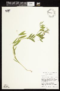 461627[1077205]Schik, K. 96-1361996-06-26 United States, Minnesota, Clay, Clay Co, T139N R46W NW1/4 of the sW1/4 of S15; at Bluestem Prairie nature Conservancy Preserve.;Bluestem Prairie Scientific Natural Area;139N;46W;15, 46.853205 -96.481201 |
MIN:Plants | 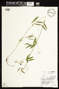 461628[1077202]Mensing, D. 96-1051996-06-29 United States, Minnesota, Clearwater, Sucker Creek. SW1/4 of SW1/4 of section;;144N;36W;29, 47.2605551 -95.2652582 |
MIN:Plants | 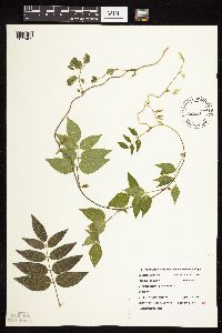 Lathyrus venosus var. intonsus Butters & H. St. John 509293[1077402]Roitsch, C. 4982000-07-31 United States, Minnesota, Morrison, [no further data];Crane Meadows National Wildlife Refuge;;;, 45.9667 -94.3667 |
MIN:Plants | 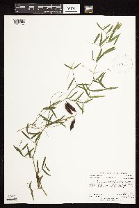 919154[1077156]Anderson, Derek 10062008-08-14 United States, Minnesota, Freeborn, Freeborn County...Panicum Prairie WMA, ca. 3.5 km east of Interstate-35 on the Minnesota-Iowa border...T101N R21W SESE35;Panicum Prairie Wildlife Management Area;101N;21W;35, 43.5013889 -93.3097222 |
MIN:Plants | 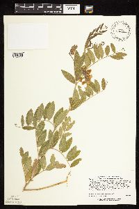 Lathyrus venosus var. intonsus Butters & H. St. John 476601[1077404]Lee, Michael MDL20961998-06-03 United States, Minnesota, Stearns, Spirit Prairie Wildlife Management Area. Stearns Co.; Spirit Prairie Wildlife Management Area 1-1/2 miles north of Paynesville; T122N R32W NE1/4 of SW1/4 of SE1/4 Sec. 4. 122N 32W 4, 45.405383 -94.7120801 |
MIN:Plants | 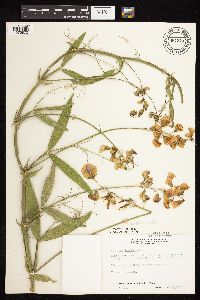 687374[1076872]Wheeler, Gerald; Glaser, Paul 18111977-06-28 United States, Minnesota, Itasca, Site 73. NE1/4 SW1/4 Sec. 22, T54N, R25W; ca. 6 mi. SSE of Grand Rapids;;054N;25W;22, 47.1452633 -93.5021806 |
MIN:Plants | 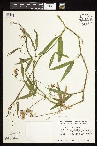 712091[1076870]Smith, Welby 18331979-08-14 United States, Minnesota, Wright, Wright Co.; T120N, R26W, SW1/4 NW1/4 Sec. 9. S side of Hwy. 55; 2.0 mi. E of its jct. with Co. Rd. 8 in Maple Lake.;;120N;26W;9, 45.2164632 -93.9602483 |
MIN:Plants | 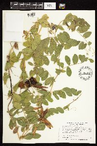 Lathyrus maritimus var. glaber (Seringe) Eames 433493[1076874]Myhre, K. 6311991-08-13 United States, Minnesota, Aitkin, Aitkin Co.; North shore of Mille Lacs Lake, the 0.5 mile str h from Reddy creek to the West, State of Minnesota land; Aitkin Co.; North shore of Mille Lacs Lake, the 0.5 mile stretch from Reddy creek to the West, State of Minnesota land; T 45N R 26W SE1/4 of NW1/4 of Sec 23. 045N 26W 23, 46.3669287 -93.5906176 |
MIN:Plants | 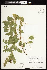 Lathyrus maritimus var. glaber (Seringe) Eames 514884[1076910]Schimpf, D.; et al. 1201983-08-23 United States, Minnesota, Cook, Grand Portage National Monument; Cook Co.; R-6E, T-63N, S-4, Visitor Center area. Beach NE of the stockade.;Grand Portage National Monument / North Shore;063N;06E;04, 47.9694745 -89.6848413 |
MIN:Plants | 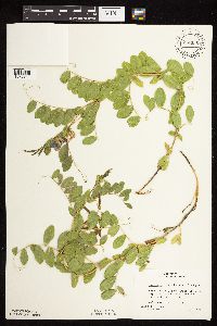 Lathyrus maritimus var. glaber (Seringe) Eames 774035[1076911]Boe, J. 6561979-07-10 United States, Minnesota, Lake of the Woods, Lake of the Woods Co. Near Rocky Point. Path through Populus stand near summer homes. NW1/4 Sec. 8, R34W, T163N.;;163N;34W;8, 48.7784429 -95.0572807 |
MIN:Plants |  Lathyrus maritimus var. glaber (Seringe) Eames 832292[1076873]Myhre, K. 28331992-07-24 United States, Minnesota, Cass, Cass Co. Located 1/4 mi W of Rogers Point in Leech Lake; T142N R29W NE1/4 of SW1/4 of Sec 31;Chippewa National Forest / Leech Lake Indian Reservation;142N;29W;31, 47.0734665 -94.3954297 |
MIN:Plants |  Lathyrus maritimus var. glaber (Seringe) Eames 138386[1076891]MacMillan, C.; et al. 22151894-06-00 United States, Minnesota, Lake of the Woods, Oak Point;Pine & Curry Islands Scientific Natural Area;162N;31W;06, 48.8797601 -94.6902456 |
MIN:Plants |  Lathyrus maritimus var. glaber (Seringe) Eames 138408[1076893]MacMillan, C.; et al. 6121894-06-26 United States, Minnesota, Lake of the Woods, Garden Island, Lake of the Woods;Northwest Angle;166N;33W;00, 49.177773 -94.858561 |
MIN:Plants |  Lathyrus maritimus var. glaber (Seringe) Eames 138410[1076913]Roberts, Thomas s.n.1878-07-00 United States, Minnesota, Saint Louis, French River;;N;;, 46.900221 -91.899188 |
MIN:Plants |  Lathyrus maritimus var. glaber (Seringe) Eames 138411[1076884]Roberts, Thomas s.n.1879-08-27 United States, Minnesota, Lake, Beaver Bay;North Shore;055N;07W;12, 47.2577 -91.300444 |
MIN:Plants |  Lathyrus maritimus var. glaber (Seringe) Eames 138412[1076892]MacMillan, C.; et al. MS10561894-07-00 United States, Minnesota, Lake of the Woods, Oak Point;Pine & Curry Islands Scientific Natural Area;162N;31W;06, 48.8797601 -94.6902456 |
MIN:Plants |  Lathyrus maritimus var. glaber (Seringe) Eames 138413[1076912]Juni, B. s.n.1878-05-00 United States, Minnesota, Saint Louis, French River;;N;;, 46.900221 -91.899188 |
MIN:Plants |  Lathyrus maritimus var. glaber (Seringe) Eames 138414[1076886]Sandberg, John s.n.1891-08-00 United States, Minnesota, Lake, Two Harbors;North Shore;052N;11W;, 47.02278 -91.67056 |
MIN:Plants | 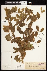 Lathyrus maritimus var. glaber (Seringe) Eames 138415[1076916]Roberts, Thomas s.n.1879-08-07 United States, Minnesota, Cook, Poplar River;Superior National Forest;064N;01W;, 47.651645 -90.716165 |
MIN:Plants | 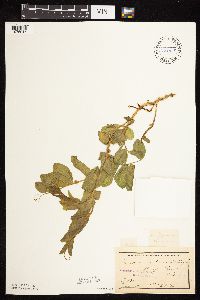 Lathyrus maritimus var. glaber (Seringe) Eames 138416[1076917]Sheldon, Edmund S49581893-06-00 United States, Minnesota, Saint Louis, Knife River;;N;;, 46.949658 -91.809689 |
MIN:Plants | 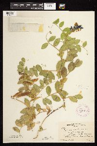 Lathyrus maritimus var. glaber (Seringe) Eames 273225[1076885]Rosendahl, C. 59711929-08-09 United States, Minnesota, Cook, Shingle beach, Grand Marais;North Shore;061N;01E;, 47.749004 -90.33968 |
MIN:Plants | 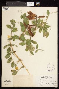 Lathyrus maritimus var. glaber (Seringe) Eames 302530[1076903]Lakela, Olga 13171935-09-26 United States, Minnesota, Saint Louis, Minnesota Point, Duluth.;Minnesota Point;049N;13W;18, 46.72833 -92.04778 |
MIN:Plants | 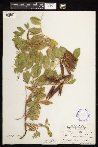 Lathyrus maritimus var. glaber (Seringe) Eames 337574[1076907]Lakela, Olga 15711936-07-23 United States, Minnesota, Saint Louis, In the "barrens", Sec. 13, R14W, T49N.;;049N;14W;13, 46.7292991 -92.0558233 |
MIN:Plants | 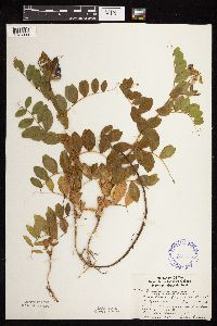 Lathyrus maritimus var. glaber (Seringe) Eames 337575[1076900]Lakela, Olga 14491936-06-25 United States, Minnesota, Saint Louis, Sec. 13, R14, T49. Lake Superior side, Duluth.;;049N;14W;13, 46.7292991 -92.0558233 |
MIN:Plants | 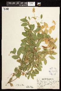 Lathyrus maritimus var. glaber (Seringe) Eames 360628[1076908]Rosendahl, C.; et al. 70101938-09-05 United States, Minnesota, Lake of the Woods, Rocky Point, Lake of the Woods.;;163N;34W;, 48.954859 -95.055648 |
MIN:Plants | 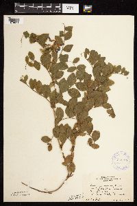 Lathyrus maritimus var. glaber (Seringe) Eames 361765[1076904]Horton, E. s.n.1936-08-04 United States, Minnesota, Saint Louis, Minnesota Point;Minnesota Point;049N;13W;18, 46.7278308 -92.1638988 |
MIN:Plants | 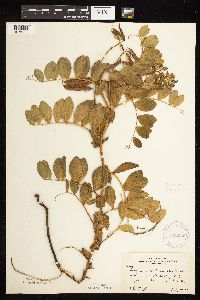 Lathyrus maritimus var. glaber (Seringe) Eames 362536[1076887]Moyle, J. 34451940-07-24 United States, Minnesota, Lake, Old beach of Lake Superior, Beaver Bay.;North Shore;055N;07W;12, 47.258632 -91.298041 |
MIN:Plants | 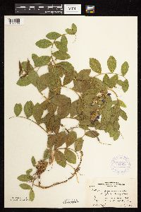 Lathyrus maritimus var. glaber (Seringe) Eames 364477[1076905]Moyle, J. 35921940-07-07 United States, Minnesota, Saint Louis, Beach of Lake Superior, Minnesota Point, Duluth.;Minnesota Point;049N;13W;18, 46.728273 -92.047968 |
MIN:Plants | 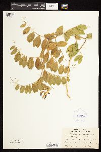 Lathyrus maritimus var. glaber (Seringe) Eames 380188[1076889]Lakela, Olga 54501943-08-25 United States, Minnesota, Lake, Lake Co. Beaver River Bay.;North Shore;055N;07W;12, 47.259196 -91.300778 |
MIN:Plants | 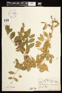 Lathyrus maritimus var. glaber (Seringe) Eames 392992[1076915]Lakela, Olga; et al. 64671946-06-26 United States, Minnesota, Saint Louis, Sandbar Island in Duluth Harbor, Duluth;;N;;, 46.771987 -92.096966 |
MIN:Plants |  Lathyrus maritimus var. glaber (Seringe) Eames 395244[1076901]Brown, Spencer 491935-00-00 United States, Minnesota, Cook, Grand Portage;Grand Portage Indian Reservation / North Shore;063N;06E;, 47.963776 -89.684812 |
MIN:Plants |  Lathyrus maritimus var. glaber (Seringe) Eames 405310[1076906]Lakela, Olga s.n.1949-07-31 United States, Minnesota, Saint Louis, Duluth;Minnesota Point;049N;13W;18, 46.78333 -92.10639 |
MIN:Plants |  Lathyrus maritimus var. glaber (Seringe) Eames 405804[1076898]Rosendahl, C. 79001948-08-14 United States, Minnesota, Cook, Grand Portage Bay;Grand Portage Indian Reservation / North Shore;063N;06E;, 47.957387 -89.670646 |
MIN:Plants | Lathyrus maritimus var. glaber (Seringe) Eames 419350[]Schuster, R.; et al. 60341947-07-15 United States, Minnesota, Cook, Lake Superior at the mouth of the Temperance River.;North Shore / Temperance River State Park;059N;04W;, 47.554465 -90.873733 |
MIN:Plants |  Lathyrus maritimus var. glaber (Seringe) Eames 437132[1076894]Moore, John; Moore, Marjorie 122341939-08-29 United States, Minnesota, Lake of the Woods, Pine & Curry Islands Scientific Natural Area. Lake of the Woods Co.; Morris Point (Oak Point), Lake of the Woods. Morris Point (Oak Point), Lake of the Woods.. 162N 31W 6, 48.8797601 -94.6902456 |
MIN:Plants |  Lathyrus maritimus var. glaber (Seringe) Eames 475463[1076876]Myhre, K. 8551991-09-02 United States, Minnesota, Aitkin, Aitkin Co.; Located along the north shore of Lake Mille Lacs; T 45N R 26W NE1/4 of SW1/4 of Sec 23;;045N;26W;23, 46.3669287 -93.5906176 |
MIN:Plants |  Lathyrus maritimus var. glaber (Seringe) Eames 494450[1076883]Huff, N. s.n.1941-08-24 United States, Minnesota, Cook, Grand Marais;North Shore;061N;01E;, 47.750447 -90.334273 |
MIN:Plants |  Lathyrus maritimus var. glaber (Seringe) Eames 526064[1076890]Lakela, Olga 193671955-08-18 United States, Minnesota, Lake of the Woods, Curry's Island, sandbar, 3 mi. out from the mouth of the Rainy River, in Lake of the Woods.;Pine & Curry Islands Scientific Natural Area;162N;32W;, 48.869911 -94.713754 |
MIN:Plants |  Lathyrus maritimus var. glaber (Seringe) Eames 583289[1076888]Kellner, H. 2361956-07-13 United States, Minnesota, Lake, Lake County...Encampment Is, in L. Superior;North Shore;053N;10W;12, 47.0964582 -91.5548498 |
MIN:Plants |  Lathyrus maritimus var. glaber (Seringe) Eames 606772[1076902]Bartlett, H.; et al. 1911952-06-25 United States, Minnesota, Cook, Cook County...Along Hwy. 61, SW of Hoveland [sic] and 3 mi. NE of Brule River.;Grand Portage State Forest / North Shore;062N;03E;, 47.820303 -90.033232 |
MIN:Plants |  Lathyrus maritimus var. glaber (Seringe) Eames 643802[1076895]Morley, T. 12831973-07-15 United States, Minnesota, Cass, Cass Co. On the S beach of the islet immediately S of Pelican Island in Leech Lake.;Chippewa National Forest / Leech Lake Indian Reservation;142N;29W;, 47.106898 -94.372262 |
MIN:Plants |  Lathyrus maritimus var. glaber (Seringe) Eames 673613[1076896]Borchard, Alma s.n.1937-08-12 United States, Minnesota, Cook, Grand Marais;North Shore;061N;01E;, 47.750447 -90.334273 |
MIN:Plants |  Lathyrus maritimus var. glaber (Seringe) Eames 695864[1076914]Clemants, Steven 9631977-10-08 United States, Minnesota, Crow Wing, Pelican Lake, Sunset Beach. 13 mi. N of Brainerd.;;136N;28W;, 46.568262 -94.147425 |
MIN:Plants |  Lathyrus maritimus var. glaber (Seringe) Eames 700598[1076882]Ownbey, Gerald 59411978-06-18 United States, Minnesota, Cass, Cass Co. T143N, R30W, SW1/4 Sec. 14. Just N of S end of Otter Tail Point. E side of isthmus near boat dock.;Chippewa National Forest / Leech Lake Indian Reservation;143N;30W;14, 47.2000746 -94.4352085 |
MIN:Plants |  Lathyrus maritimus var. glaber (Seringe) Eames 726305[1076919]Smith, Welby 25201980-06-14 United States, Minnesota, Saint Louis, Minnesota Point, Duluth. Shore of Lake Superior.;Minnesota Point;049N;14W;, 46.728273 -92.047968 |
MIN:Plants |  Lathyrus maritimus var. glaber (Seringe) Eames 738145[1076897]Johnson, Eugene 371961-07-17 United States, Minnesota, Saint Louis, Minnesota Point: Near the amusement park.;Minnesota Point;049N;13W;18, 46.7278308 -92.1638988 |
MIN:Plants |  Lathyrus maritimus var. glaber (Seringe) Eames 770102[1076875]Smith, Welby 86201983-08-11 United States, Minnesota, Lake of the Woods, Lake of the Woods Co. Zippel Bay State Park. On the S shore of Lake of the Woods. SE1/4 SW1/4 Sec. 2, T162N, R33W.;Zippel Bay State Park;162N;33W;2, 48.8802391 -94.8612238 |
MIN:Plants |  Lathyrus maritimus var. glaber (Seringe) Eames 773788[1076899]Boe, J. 7291979-07-12 United States, Minnesota, Lake of the Woods, Lake of the Woods Co.; Morris Point; T162N, R32W, Sec. 16. Lake of the Woods Co. Morris Point sandbar. T162N, R32W, Sec. 16.. 162N 32W 16, 48.8516383 -94.7732985 |
MIN:Plants |  Lathyrus maritimus var. glaber (Seringe) Eames 773827[1076918]Boe, J. 7741979-07-14 United States, Minnesota, Lake of the Woods, Lake of the Woods Co. Zippel Bay State Park. NW1/4 Sec. 12, R33W, T162N.;Zippel Bay State Park;162N;33W;12, 48.8658915 -94.8389661 |
MIN:Plants |  Lathyrus maritimus var. glaber (Seringe) Eames 833129[1076879]Myhre, K. 23351992-06-23 United States, Minnesota, Cass, Cass Co. Located 1 mi S of Five Mile Point on Battleground Peninsula in Leech Lake; T143N R29W SW1/4 of SW1/4 of Sec.14;Chippewa National Forest / Leech Lake Indian Reservation;143N;29W;14, 47.2046446 -94.3191672 |
MIN:Plants |  Lathyrus maritimus var. glaber (Seringe) Eames 834395[1076881]Smith, Welby 200731991-08-28 United States, Minnesota, Cook, Grand Portage State Forest / North Shore. Cook Co. Paradise Beach, on the N shore of Lake Superior, about 7 miles W-SW of Hovland; Cook Co. Paradise Beach, on the N shore of Lake Superior, about 7 miles W-SW of Hovland; T062N R03E NW1/4 of SW1/4 of Sec 33. 062N 03E 33, 47.8058319 -90.0800018 |
MIN:Plants |  Lathyrus ochroleucus Hooker 138450[1076956]Ballard, C. s.n.1891-07-00 United States, Minnesota, Scott, Prior Lake;;N;;, 44.724031 -93.43234 |
MIN:Plants |  Lathyrus ochroleucus Hooker 138482[1076954]Manning, Warren 6531883-06-19 United States, Minnesota, Wabasha, Lake City;;N;;, 44.449412 -92.266844 |
MIN:Plants |  Lathyrus ochroleucus Hooker 138483[1076997]Hollinshead, C. 462000-05-17 United States, Minnesota, Ramsey, St. Anthony Park [St. Paul neighborhood near U of M];;029N;23W;, 44.983574 -93.195102 |
MIN:Plants |  Lathyrus ochroleucus Hooker 138484[1077002]Manning, Sara s.n.1883-06-19 United States, Minnesota, Wabasha, Lake City;;N;;, 44.449412 -92.266844 |
MIN:Plants |  Lathyrus ochroleucus Hooker 138485[1077003]Manning, Sara s.n.1892-06-09 United States, Minnesota, Wabasha, Lake City;;N;;, 44.449412 -92.266844 |
MIN:Plants | 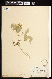 Lathyrus ochroleucus Hooker 138503[1077020]Rosendahl, C.; Butters, F. 29931915-06-21 United States, Minnesota, Fillmore, 3 mi. W of Rushford;;104N;08W;, 43.808282 -91.813138 |
MIN:Plants | 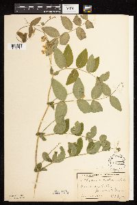 Lathyrus ochroleucus Hooker 138504[1077018]Lyon, H. s.n.1899-06-12 United States, Minnesota, Houston, Winnebago Valley;Dorer Memorial Hardwood State Forest;N;;, 43.539205 -91.384455 |
MIN:Plants | 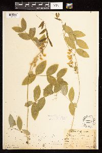 Lathyrus ochroleucus Hooker 138505[1122706]Sandberg, John s.n.1889-06-00 United States, Minnesota, Hennepin, [no further data];;;;, 45 -93.47 |
MIN:Plants | 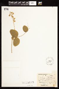 Lathyrus ochroleucus Hooker 138506[1122705]Aiton, G. s.n. United States, Minnesota, Nicollet, Nicollet Co.;;N;;, 44.363625 -94.316053 |
MIN:Plants |  Lathyrus ochroleucus Hooker 138507[1077053]Aiton, G. s.n.1891-06-00 United States, Minnesota, Hennepin, near Minneapolis;;N;;, 44.970736 -93.263836 |
MIN:Plants |  Lathyrus ochroleucus Hooker 138508[1076980]Aiton, G. s.n.1891-06-00 United States, Minnesota, Clearwater, Lake Itasca;Itasca State Park;143N;36W;, 47.215169 -95.19703 |
MIN:Plants |  Lathyrus ochroleucus Hooker 138509[1076941]Aiton, G. s.n.1891-06-00 United States, Minnesota, Hennepin, near Minneapolis;;N;;, 44.970736 -93.263836 |
MIN:Plants |  Lathyrus ochroleucus Hooker 138510[1076942]Kassube, J. s.n.1878-05-00 United States, Minnesota, Hennepin, Minneapolis;;N;;, 44.970736 -93.268643 |
MIN:Plants | 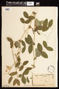 Lathyrus ochroleucus Hooker 138511[1077047]Campbell, Jennie s.n.1897-07-00 United States, Minnesota, Otter Tail, Leaf Mountain;;N;;, 46.165947 -95.648888 |
MIN:Plants | 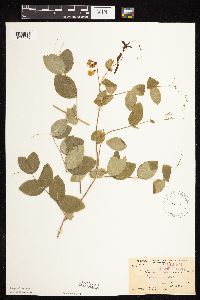 Lathyrus ochroleucus Hooker 138513[1076972]Arthur, J.; et al. 63A1886-07-20 United States, Minnesota, Saint Louis, Vermilion Lake;;;;, 47.88053 -92.338672 |
MIN:Plants | 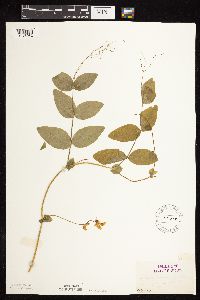 Lathyrus ochroleucus Hooker 138514[1076982]Herrick, C. 46-131878-06-18 United States, Minnesota, Hennepin, Minneapolis;;N;;, 44.970736 -93.268643 |
MIN:Plants | 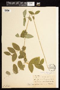 Lathyrus ochroleucus Hooker 138515[1077052]Sheldon, Edmund S25841892-06-00 United States, Minnesota, Mille Lacs, Mille Lacs Reservation;Mille Lacs Indian Reservation;N;;, 46.117896 -93.622253 |
MIN:Plants | 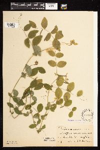 Lathyrus ochroleucus Hooker 138516[1077051]Sheldon, Edmund S21511892-06-00 United States, Minnesota, Crow Wing, Boy Lake;;;;, 46.384417 -93.854091 |
MIN:Plants | 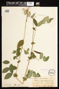 Lathyrus ochroleucus Hooker 138517[1077021]Ballard, C. B5971891-07-00 United States, Minnesota, Scott, Prior Lake;;N;;, 44.724031 -93.43234 |
MIN:Plants | 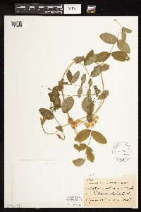 Lathyrus ochroleucus Hooker 138518[1079963]Frost, W. F861892-06-00 United States, Minnesota, Meeker, Litchfield;;N;;, 45.127185 -94.528047 |
MIN:Plants | 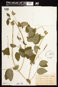 Lathyrus ochroleucus Hooker 138519[1076983]Ballard, C. B2301891-06-00 United States, Minnesota, Scott, Jordan, Scott Co.;;114N;23W;, 44.667151 -93.633081 |
MIN:Plants |  Lathyrus ochroleucus Hooker 13852[1077065]Frost, W. F861892-06-00 United States, Minnesota, Meeker, Litchfield;;N;;, 45.127185 -94.528047 |
MIN:Plants |  Lathyrus ochroleucus Hooker 138520[1076981]Pomeroy, J. P331880-05-00 United States, Minnesota, Hennepin, Minneapolis;;N;;, 44.970736 -93.268643 |
MIN:Plants |  Lathyrus ochroleucus Hooker 138521[1077007]Sheldon, Edmund S1601891-06-00 United States, Minnesota, Blue Earth, Madison Lake;;N;;, 44.189151 -93.801775 |
MIN:Plants |  Lathyrus ochroleucus Hooker 138522[1077001]Sheldon, Edmund s.n.1894-05-00 United States, Minnesota, Hennepin, Minneapolis;;N;;, 44.970736 -93.268643 |
MIN:Plants |  Lathyrus ochroleucus Hooker 138523[1076973]Arthur, J.; et al. B1871886-07-21 United States, Minnesota, Saint Louis, Vermilion Lake;;;;, 47.88053 -92.338672 |
MIN:Plants |  Lathyrus ochroleucus Hooker 138524[1076987]Sheldon, Edmund S23161892-06-00 United States, Minnesota, Aitkin, Nichols;;044N;27W;04, 46.32387 -93.75721 |
MIN:Plants |  Lathyrus ochroleucus Hooker 138525[1077000]Sandberg, John s.n.1894-05-00 United States, Minnesota, Hennepin, Vicinity of Minneapolis;;N;;, 44.969279 -93.263149 |
MIN:Plants |  Lathyrus ochroleucus Hooker 138527[1076945]Sheldon, Edmund s.n.1892-06-00 United States, Minnesota, Crow Wing, Bay Lake;;N;;, 46.386235 -93.854351 |
MIN:Plants |  Lathyrus ochroleucus Hooker 138528[1076946]Sheldon, Edmund s.n.1892-06-00 United States, Minnesota, Aitkin, Nichols;;044N;27W;04, 46.32387 -93.75721 |
MIN:Plants |  Lathyrus ochroleucus Hooker 138531[1077008]Ballard, C. B12311893-06-00 United States, Minnesota, Cass, Gull Lake;;N;;, 46.445433 -94.36335 |
MIN:Plants |  Lathyrus ochroleucus Hooker 138532[1076955]Sheldon, Edmund S49591893-06-00 United States, Minnesota, Lake, Knife River;North Shore;052N;11W;31, 46.94743 -91.78709 |
MIN:Plants |  Lathyrus ochroleucus Hooker 138533[1076947]Frost, W. F861892-06-00 United States, Minnesota, Meeker, Litchfield;;N;;, 45.127185 -94.528047 |
MIN:Plants | 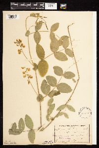 Lathyrus ochroleucus Hooker 138534[1076999]Sheldon, Edmund s.n.1895-05-00 United States, Minnesota, Hennepin, Lake Calhoun;;N;;, 44.941864 -93.311733 |
MIN:Plants | 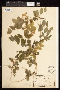 Lathyrus ochroleucus Hooker 138535[1077042]Anderson, A. A4081893-06-00 United States, Minnesota, Cass, Gull Lake;;N;;, 46.445433 -94.36335 |
Google Map
Google Maps is a web mapping service provided by Google that features a map that users can pan (by dragging the mouse) and zoom (by using the mouse wheel). Collection points are displayed as colored markers that when clicked on, displays the full information for that collection. When multiple species are queried (separated by semi-colons), different colored markers denote each individual species.