University of Minnesota
http://www.umn.edu/
612-625-5000
http://www.umn.edu/
612-625-5000
Minnesota Biodiversity Atlas
Bell Museum
Dataset: MIN-Plants
Taxa: Lipocarpha
Search Criteria: excluding cultivated/captive occurrences
1
Page 1, records 1-73 of 73
Bell Museum plants | |
 MIN:Plants |  Lipocarpha micrantha (Vahl) G.C. Tucker 464489[1021576]Dana, R. RPD 970061997-07-22 United States, North Dakota, Ransom, Ransom County ... Sheyenne National Grassland, "Wall Allotment" ... T135N R53W NE1/4 sec. 33;Sheyenne National Grasslands;135N;53W;33 |
MIN:Plants |  Lipocarpha micrantha (Vahl) G.C. Tucker 431377[1021534]Lee, Michael MDL41862005-09-15 United States, Minnesota, Morrison, MORRISON COUNTY ... Mississippi River just upstream from the Royalton Sportsman's Club landing; 1/2 mile upstream from the County Road 26 bridge; two miles west of Royalton ... T39N R32W N1/2 of SW1/4 of NW1/4 Sec.33 (slightly irregular section). 039N 32W 33, 45.829439 -94.335437 |
MIN:Plants |  Lipocarpha drummondii (Nees) G.C. Tucker 531761[1021523]Umbach, L. 62921912-09-14 United States, Indiana, Porter, Northern Porter County ... Dune Park on Lake Michigan (7 mi. E. of Gary, Ind, SE of Chicago);Indiana Dunes National Lakeshore;;;, 41.663093 -87.032128 |
MIN:Plants |  Lipocarpha micrantha (Vahl) G.C. Tucker 699672[1021575]Ziegler, S.; et al. 20141975-07-24 United States, Wisconsin, La Crosse, La Crosse Co.; Island 18; Mississippi River-mile #693.3; T15N R7W Sec 29 ... Island on E side of main channel;Upper Mississippi National Wildlife Refuge;015N;07W;29, 193m |
MIN:Plants |  Lipocarpha micrantha (Vahl) G.C. Tucker 459574[1021527]McKenzie, Paul 19392000-09-17 United States, Minnesota, Washington, Afton State Park. Washington County: Afton State Park, ca. 3 mi. southof Afton; T27N, R20W, SE/4 [sic] of the SW1/4 of Sec. 2...at confluence of Trout Brook and the St. Croix River, adjacent to public beach and picnic area.. 027N 20W 2, 44.854763 -92.775046 |
MIN:Plants |  Lipocarpha micrantha (Vahl) G.C. Tucker 221987[1021574]Rosendahl, C. 41401921-08-31 United States, Wisconsin, Saint Croix, St. Croix River about 2-1/2 miles N. of Stillwater, St. Croix County;Saint Croix National Riverway;;;, 45.093688 -92.758563 |
MIN:Plants | 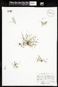 Lipocarpha micrantha (Vahl) G.C. Tucker 903370[1021537]Lee, Michael MDL41582005-09-08 United States, Minnesota, Benton, BENTON COUNTY ... Graham's Island in the Mississippi River at the State Hwy 15 bridge in Sartell / Sauk Rapids ... T36N R31W NE1/4 of SE1/4 of NW1/4 Sec.22 (small, irregular section) also SE1/4 of NE1/4 of NW1/4 Sec.22. 036N 31W 22, 45.598931 -94.181749 |
MIN:Plants | 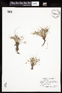 Lipocarpha micrantha (Vahl) G.C. Tucker 920318[1021536]Smith, Welby 258561995-08-17 United States, Minnesota, Hennepin, Hennepin County ... About 1/4 mile downstream (south) of the Lake Street Bridge in Minneapolis ... Mississippi River ... T28N R23W SE1/4 of NW1/4 of Sec 5. 028N 23W 5, 44.9438889 -93.2022222 |
MIN:Plants | 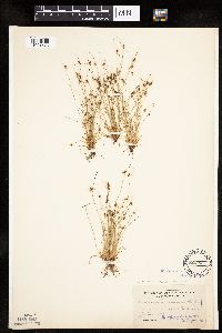 Lipocarpha micrantha (Vahl) G.C. Tucker 82550[1021573]Umbach, L. s.n.1897-07-30 United States, Indiana, Porter, Dune Park;Indiana Dunes National Lakeshore;;;, 41.663093 -87.032128 |
MIN:Plants | 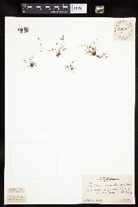 Lipocarpha micrantha (Vahl) G.C. Tucker 222028[1021539]Rosendahl, C. 54061927-08-26 United States, Minnesota, Anoka, Bunker Lake.;Bunker Hills County Park;032N;24W;, 45.218819 -93.275736 |
MIN:Plants |  Lipocarpha micrantha (Vahl) G.C. Tucker 222042[1021540]Rosendahl, C. s.n.1927-10-05 United States, Minnesota, Hennepin, Banks of the Mississippi River, below campus, Minneapolis.;;N;;, 44.905162 -93.166462 |
MIN:Plants |  Lipocarpha micrantha (Vahl) G.C. Tucker 224364[1021555]Rosendahl, C.; et al. s.n.1917-09-28 United States, Minnesota, Anoka, Anoka County...Along the shore of Moore Lake.;;030N;24W;, 45.080985 -93.255535 |
MIN:Plants |  Lipocarpha micrantha (Vahl) G.C. Tucker 306195[1021533]Delaney, B. s.n.1987-09-26 United States, Minnesota, Anoka, Anoka Co. Cedar Creek Natural History Area. E shore of Fish Lake.;Cedar Creek National History Area;034N;23W;25, 45.392318 -93.172984 |
MIN:Plants |  Lipocarpha micrantha (Vahl) G.C. Tucker 346301[1021563]Grant, Martin 68141936-08-21 United States, Minnesota, Becker, Itasca Park. Becker Co. De Soto Lake. NW-NE-3 T142 R36;Itasca State Park;142N;36W;3, 47.145259 -95.222785 |
MIN:Plants |  Lipocarpha micrantha (Vahl) G.C. Tucker 359120[1021549]Moyle, J. 33661939-08-17 United States, Minnesota, Hennepin, Banks of the Crow River near Dayton.;;N;;, 45.243854 -93.514958 |
MIN:Plants |  Lipocarpha micrantha (Vahl) G.C. Tucker 362006[1021567]Moyle, J. 34801940-09-21 United States, Minnesota, Isanti, Florence Lake.;;035N;23W;, 45.514743 -93.203853 |
MIN:Plants |  Lipocarpha micrantha (Vahl) G.C. Tucker 362695[1021560]Rosendahl, C.; Butters, F. 67621936-08-31 United States, Minnesota, Pine, Sturgeon Lake, Pine Co.;;045N;19W;, 46.374946 -92.7409 |
MIN:Plants |  Lipocarpha micrantha (Vahl) G.C. Tucker 370713[1021566]Moore, John; et al. 137261940-10-01 United States, Minnesota, Isanti, N shore of Spectacle Lake.;Spectacle Lake Wildlife Management Area;036N;25W;26, 45.579704 -93.420007 |
MIN:Plants |  Lipocarpha micrantha (Vahl) G.C. Tucker 405813[1021554]Rosendahl, C. 79241948-09-24 United States, Minnesota, Chisago, Banks of the St. Croix River, 1 mi. S of Taylors Falls.;;033N;19W;, 45.345489 -92.737347 |
MIN:Plants |  Lipocarpha micrantha (Vahl) G.C. Tucker 440475[1021526]Evans, Karen 32401992-08-31 United States, Minnesota, Cass, Cass Co. Located on the W shore of Spider Lake; T137N R32W NW1/4 of NE1/4 of Sec.24;Foothills State Forest;137N;32W;24, 46.666344 -94.670409 |
MIN:Plants |  Lipocarpha micrantha (Vahl) G.C. Tucker 440813[1021525]Myhre, K. 33581992-09-23 United States, Minnesota, Cass, Cass Co. Located on the NW bay of Town Line Lake; T142N R28W SW1/4 of SW1/4 of Sec 34;Chippewa National Forest / Leech Lake Indian Reservation;142N;28W;34, 47.075113 -94.214572 |
MIN:Plants |  Lipocarpha micrantha (Vahl) G.C. Tucker 444686[1021572]Moore, John; et al. 183791945-10-09 United States, Minnesota, Anoka, Along lake shore just N of Bunker Lake.;Bunker Hills County Park;032N;24W;, 45.218819 -93.275736 |
MIN:Plants | 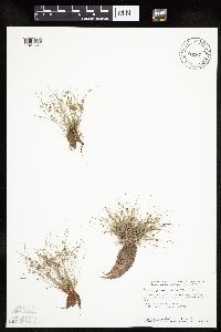 Lipocarpha micrantha (Vahl) G.C. Tucker 460568[1021541]Smith, Welby 145841988-07-22 United States, Minnesota, Washington, Washington Co.; St. Croix River in the town of Afton. NW1/4 SW1/4 section 23, T 28N R 20W;Saint Croix National Riverway;028N;20W;23, 44.898056 -92.7788925 |
MIN:Plants | 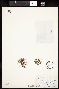 Lipocarpha micrantha (Vahl) G.C. Tucker 506726[1021548]Rosendahl, C. 79431950-10-18 United States, Minnesota, Chisago, Banks of the St. Croix River, ca. 1 mi. S of Taylors Falls.;;033N;19W;, 45.345489 -92.737347 |
MIN:Plants | 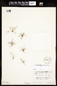 Lipocarpha micrantha (Vahl) G.C. Tucker 550092[1021562]Moore, John 220881954-09-15 United States, Minnesota, Sherburne, Along the banks of the Mississippi River, 3 mi. SW of Clear Lake.;;N;;, 45.41424 -94.042653 |
MIN:Plants | 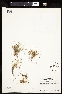 Lipocarpha micrantha (Vahl) G.C. Tucker 553606[1021570]Bernardini, J.; Moore, John 1371958-09-19 United States, Minnesota, Blue Earth, 1 1/2 mi. S of Mankato along the Blue Earth River.;;N;;, 44.137182 -94.040774 |
MIN:Plants | 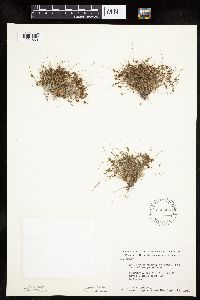 Lipocarpha micrantha (Vahl) G.C. Tucker 566663[1021569]Moore, John; Bernardini, J. 243131958-09-19 United States, Minnesota, Blue Earth, Along the Blue Earth River, 1 mi. S of Mankato.;;N;;, 44.137182 -94.040774 |
MIN:Plants | 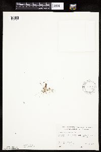 Lipocarpha micrantha (Vahl) G.C. Tucker 578889[1021571]Ownbey, Gerald; Bloom, W. 34491962-08-23 United States, Minnesota, Becker, Becker Co. SE side of De Soto Lake. T142N R36W Sec.3 S1/2.;Itasca State Park;142N;36W;3, 47.145259 -95.222785 |
MIN:Plants | 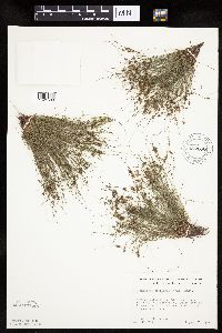 Lipocarpha micrantha (Vahl) G.C. Tucker 672696[1021568]Wheeler, Gerald 9301976-08-30 United States, Minnesota, Hennepin, Hennepin Co. Fort Snelling State Park, near Fort Snelling in Minneapolis. On the W bank of the Mississippi River.;Fort Snelling State Park;N;;, 44.905162 -93.166462 |
MIN:Plants | 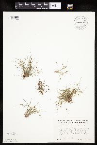 Lipocarpha micrantha (Vahl) G.C. Tucker 672735[1021565]Wheeler, Gerald 9391976-08-31 United States, Minnesota, Chisago, N of Rte. 243; ca. 1/2 mi. E of the jct. of Rte. 95 and Rte. 243, just W of the bridge to Osceola, Wis. On a bank of th N of Rte. 243; ca. 1/2 mi. E of the jct. of Rte. 95 and Rte. 243, just W of the bridge to Osceola, Wis. On a bank of the St. Croix River.. N , 45.318889 -92.724307 |
MIN:Plants | 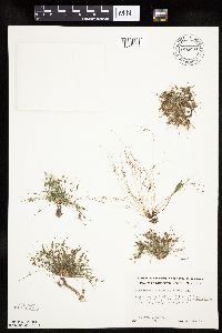 Lipocarpha micrantha (Vahl) G.C. Tucker 676230[1021535]Clemants, Steven 5561976-09-02 United States, Minnesota, Sherburne, Ca. 1 mi. N of the town of Clearwater. Mississippi River bed.;;034N;30W;23, 45.422477 -94.036033 |
MIN:Plants | 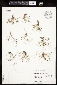 Lipocarpha micrantha (Vahl) G.C. Tucker 676324[1021543]Ownbey, Gerald 54551976-08-29 United States, Minnesota, Washington, T127N R20W NW1/4 Sec.2, Afton State Park; along delta of Trout Brook at its confluence with the St. Croix River.;Afton State Park;027N;20W;2, 44.854763 -92.775046 |
MIN:Plants |  Lipocarpha micrantha (Vahl) G.C. Tucker 681818[1021561]Wheeler, Gerald 11561977-06-21 United States, Minnesota, Wright, Wright Co.; approx. 2 mi. SE of Clearwater. On the W shore of the Mississippi River.;;122N;26W;7, 45.390467 -94.00344 |
MIN:Plants |  Lipocarpha micrantha (Vahl) G.C. Tucker 687532[1021552]Wheeler, Gerald; Glaser, Paul 19741977-07-09 United States, Minnesota, Itasca, Ca. 10.5 mi. N of Grand Rapids. On the N side of Bosely Lake, just S of Hwy. 60.;;057N;25W;30, 47.393012 -93.567693 |
MIN:Plants |  Lipocarpha micrantha (Vahl) G.C. Tucker 687803[1021558]Wheeler, Gerald; Glaser, Paul 22491977-07-24 United States, Minnesota, Itasca, Ca. 10.5 mi. N of Grand Rapids. On the N side of Bosely Lake, just S of Hwy. 60.;;057N;25W;30, 47.393012 -93.567693 |
MIN:Plants | 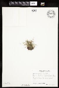 Lipocarpha micrantha (Vahl) G.C. Tucker 687850[1021559]Wheeler, Gerald; Glaser, Paul 22961977-07-28 United States, Minnesota, Itasca, Ca. 11.5 mi. N-NW of Grand Rapids. On the W side of Pughole Lake, just E of Hwy. 38.;;057N;26W;24, 47.407462 -93.588795 |
MIN:Plants | 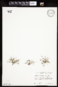 Lipocarpha micrantha (Vahl) G.C. Tucker 708362[1021542]Ownbey, Gerald 65261979-09-17 United States, Minnesota, Washington, T32N R19W Sec.31 NE1/4. Wm. O;Brien State Park along St. Croix River.;William O'Brien State Park;032N;19W;31, 45.217153 -92.76414 |
MIN:Plants | 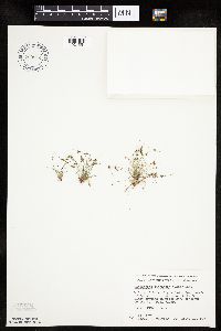 Lipocarpha micrantha (Vahl) G.C. Tucker 709914[1021551]Wheeler, Gerald 49371979-09-17 United States, Minnesota, Washington, William O'Brien State Park; just N of Marine on St. Croix on rt 95. Adjacent to the St. Croix River. T32N R19W Sec.31.;William O'Brien State Park;032N;19W;31, 45.217153 -92.76414 |
MIN:Plants | 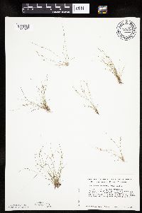 Lipocarpha micrantha (Vahl) G.C. Tucker 724236[1021529]Smith, Welby 29041980-07-20 United States, Minnesota, Wright, Wright Co.; on the S bank of the Mississippi River, about 1/4 mi. E of Clearwater. T123N R27W, SE1/4 SE1/4 of sec.35;;123N;27W;35, 45.416899 -94.04856 |
MIN:Plants | 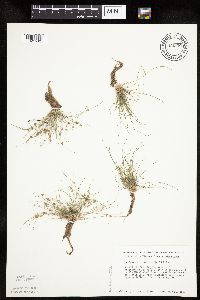 Lipocarpha micrantha (Vahl) G.C. Tucker 724508[1021532]Smith, Welby 29351980-07-20 United States, Minnesota, Wright, Wright Co.; T121N R25W, NE1/4 SE1/4 of sec.3; on the W bank of the Mississippi River, ca. 1/2 mi. W of Monticello.;;121N;25W;3, 45.316524 -93.819511 |
MIN:Plants | 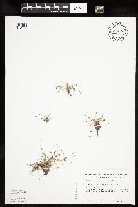 Lipocarpha micrantha (Vahl) G.C. Tucker 724538[1021528]Smith, Welby 35121980-08-23 United States, Minnesota, Wright, Wright Co.; W bank of the Mississippi River, at its confluence with the Crow River, just W of Dayton. T121N R23W, SE1/4 Wright Co.; W bank of the Mississippi River, at its confluence with the Crow River, just W of Dayton. T121N R23W, SE1/4 NE1/4 of sec.36. 121N 23W 36, 45.080368 -93.740949 |
MIN:Plants | 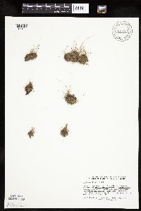 Lipocarpha micrantha (Vahl) G.C. Tucker 817125[1021538]Delaney, B. 892831989-08-24 United States, Minnesota, Isanti, Along shoreline on NW side of the peninsula that protrudes into Horseshoe Lake from the S; SE1/4 SW1/4 Sec. 2 T34N R22W;;034N;22W;2, 45.463224 -93.052381 |
MIN:Plants |  Lipocarpha micrantha (Vahl) G.C. Tucker 824523[1021524]Cholewa, A.; et al. 20211991-07-18 United States, Minnesota, Ramsey, Ramsey Co, Fort Snelling State Park, S side of Pike Island, T28N R23W S21.;Fort Snelling State Park;028N;23W;21, 44.891107 -93.166952 |
MIN:Plants |  Lipocarpha micrantha (Vahl) G.C. Tucker 82548[1021546]Rosendahl, C. s.n.1922-10-04 United States, Minnesota, Hennepin, Below High Dam, near Soldiers Home.;;N;;, 44.905162 -93.166462 |
MIN:Plants |  Lipocarpha micrantha (Vahl) G.C. Tucker 82565[1021545]Rosendahl, C. 39831920-10-01 United States, Minnesota, Hennepin, Banks of the Mississippi River, S of campus, Minneapolis.;;;;, 44.905162 -93.166462 |
MIN:Plants |  Lipocarpha micrantha (Vahl) G.C. Tucker 82566[1021564]Sheldon, Edmund s.n.1894-09-00 United States, Minnesota, Hennepin, Meeker Island [Big Island, Lake Minnetonka].;;N;;, 44.92913 -93.564124 |
MIN:Plants |  Lipocarpha micrantha (Vahl) G.C. Tucker 82567[1021550]Rosendahl, C.; Butters, F. 37831918-10-12 United States, Minnesota, Washington, Echo Lake. Washington Co.;;030N;21W;17, 45.086638 -92.954623 |
MIN:Plants |  Lipocarpha micrantha (Vahl) G.C. Tucker 82568[1021557]Butters, F. s.n.1919-09-14 United States, Minnesota, Washington, Washington Co.; Lake St. Croix;;;;, 44.921944 -92.77 |
MIN:Plants |  Lipocarpha micrantha (Vahl) G.C. Tucker 82569[1021547]Anderson, A. An9151894-07-00 United States, Minnesota, Chisago, Lindstrom.;;N;;, 45.389408 -92.847992 |
MIN:Plants |  Lipocarpha micrantha (Vahl) G.C. Tucker 82570[1021553]Leiberg, John s.n.1883-00-00 United States, Minnesota, Blue Earth, Banks of the Le Sueur River.;;N;;, 44.107621 -93.874266 |
MIN:Plants |  Lipocarpha micrantha (Vahl) G.C. Tucker 835565[1021556]Monson, Paul 39691959-07-12 United States, Minnesota, Becker, Becker Co, R-36W, T-142N, SE1/4 S-3. Itasca State Park; E shore of De Soto Lake;Itasca State Park;142N;36W;3, 47.145259 -95.222785 |
MIN:Plants |  Lipocarpha micrantha (Vahl) G.C. Tucker 836110[1021544]Monson, Paul 44451961-07-14 United States, Minnesota, Becker, Becker Co. R-36 T-142 S-3. De Soto Lake; near De Soto Cabin;Itasca State Park;142N;36W;3, 47.145259 -95.222785 |
MIN:Plants |  Lipocarpha micrantha (Vahl) G.C. Tucker 841618[1021531]Smith, Welby 137581987-08-06 United States, Minnesota, Washington, Washington County...Island in Conoly Lake on the Mississippi River Bottoms, about 2 mi W of Point Douglas SE1/4 SW1/4 sec.8, T26N R20W. 026N 20W 8, 44.7508333 -92.8344444 |
MIN:Plants |  Lipocarpha micrantha (Vahl) G.C. Tucker 841628[1021530]Smith, Welby 133621987-07-07 United States, Minnesota, Washington, Washington Co. Island in the St. Croix River, about 2 mi NE of Scandia; SE1/4 SE1/4 sec.7, T32N R19W;;032N;19W;7, 45.2675018 -92.7555542 |
MIN:Plants |  Lipocarpha micrantha (Vahl) G.C. Tucker 439987[1105053]Lee, Michael; et al. MDL37492004-07-29 United States, Minnesota, Wright, WRIGHT COUNTY ... Along the Mississippi River three miles northwest of Monticello ... Adjacent to the Monticello nuclear power plant ... T122N R25W N1/2 of SE1/4 of NE1/4 Sec. 32 (irregular section) ... UTM: 5020442N, 433248E. 122N 25W 32, 45.331908 -93.860001 |
MIN:Plants |  Lipocarpha micrantha (Vahl) G.C. Tucker 901013[1105052]Lee, Michael MDL41672005-09-08 United States, Minnesota, Stearns, Stearns County...Along the Mississippi River on the north side of St. Cloud. On downstream end of small island at the mouth of the Sauk River...T125N R28W E1/2 of NW1/4 of SW1/4 sec. 35. 125N 28W 35, 45.589261 -94.176157 |
MIN:Plants |  Lipocarpha micrantha (Vahl) G.C. Tucker 765775[1105055]Umbach, L. s.n.1896-07-18 United States, Indiana, Porter, Dune Park;Indiana Dunes National Lakeshore;;;, 41.663093 -87.032128 |
MIN:Plants |  Lipocarpha occidentalis (A. Gray) G.C. Tucker 359710[1105060]Mason, Herbert 119451938-07-13 United States, California, Mariposa, base of El Capitan, Yosemite Valley, Mariposa County. Yosemite National Park;Yosemite National Park, 1227m |
MIN:Plants | 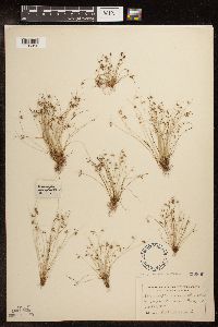 Lipocarpha micrantha (Vahl) G.C. Tucker 250899[1105056]Umbach, L. s.n.1899-09-12 United States, Indiana, Porter, Dune Park;Indiana Dunes National Lakeshore;;;, 41.663093 -87.032128 |
MIN:Plants | 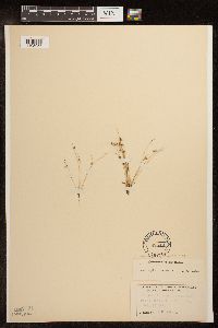 Lipocarpha micrantha (Vahl) G.C. Tucker 82549[1105057]Umbach, L. s.n.1896-07-18 United States, Indiana, Porter, Dune Park;Indiana Dunes National Lakeshore;;;, 41.663093 -87.032128 |
MIN:Plants |  Lipocarpha occidentalis (A. Gray) G.C. Tucker 359709[1105059]Mason, Herbert 119041938-07-10 United States, California, Tuolumne, Miguel Meadow, west of Hetch-Hetchy, Tuolumne County. Yosemite National Park.;Yosemite National Park, 1585m |
MIN:Plants |  Lipocarpha micrantha (Vahl) G.C. Tucker 932162[1105054]Lee, Michael MDL48842008-09-25 United States, Minnesota, Cass, Along the Paul Bunyan State Trail (old Burlington Northern Railroad), six miles north of Hackensack, six miles south of Walker. On the northeast shore of Portage Lake. E1/2 of NE1/4 of SW1/4 of section;;141N;31W;24, 47.0162764 -94.5462387 |
MIN:Plants |  Lipocarpha occidentalis (A. Gray) G.C. Tucker 234052[1105058]Congdon, J. s.n.1883-09-17 United States, California, Mariposa, Wawona;Yosemite National Park |
MIN:Plants |  Lipocarpha micrantha (Vahl) G.C. Tucker 297425[1118933]Smith, Welby R. 298742006-08-29 United States, Minnesota, Scott, Louisville Swamp, about 7 miles southwest of Shakopee. NE of SE of section;;115N;23W;31, 44.726293 -93.627916 |
MIN:Plants |  Lipocarpha micrantha (Vahl) G.C. Tucker 941976[1285248]Smith, Welby R. 299022006-09-07 United States, Minnesota, Le Sueur, Near the public access at the northwest end of Lake Pepin, about 2 miles north-northwest of Montgomery. NE of NW of section;;112N;23W;33, 44.4691166 -93.5993572 |
MIN:Plants |  Lipocarpha micrantha (Vahl) G.C. Tucker 944001[1285249]Serres, Terry s.n.2015-09-15 United States, Minnesota, Dakota, Rosemount. In spring Lake, 558 m at 69° from the canoe launch off the Archery Trail in Lower Spring Lake Park Reserve. T115N R18W SW1/4 of SE1/4 of Sec. 16, 44.763056 -92.980278 |
MIN:Plants |  Lipocarpha micrantha (Vahl) G.C. Tucker 945895[1291569]Smith, Welby R. WRS348132013-08-28 United States, Minnesota, Sherburne, A sand bar along the east bank of the Mississippi River, in the town of Elk River. NE of SW of section; T032N R26W sec03, 45.2923333 -93.55925 |
MIN:Plants |  Lipocarpha micrantha (Vahl) G.C. Tucker 945914[1291550]Smith, Welby R. WRS348352013-09-13 United States, Minnesota, Goodhue, On a low, sandbar-like island in Sturgeon Lake. This is a bottomland lake connected to the main channel of the Mississippi River, about 5 miles northwest of the city of Red Wing. NW of SW of section; T114N R15W sec29, 44.6478 -92.65135 |
MIN:Plants |  Lipocarpha micrantha (Vahl) G.C. Tucker 945959[1291525]Smith, Welby R. WRS352702014-09-04 United States, Minnesota, Winona, Pool 6 of the Mississippi River, about 14.5 km (9 miles) E-SE of the approximate center of Winona. NE of NE of section; T106N R05W sec07, 44.00455 -91.4618167 |
MIN:Plants |  Lipocarpha micrantha (Vahl) G.C. Tucker 948401[1292669]Smith, Welby R. 341792012-08-14 United States, Minnesota, Pine, Dago Lake, about 3.8 miles (6 km) northeast of the town of Willow River. T45N R19W SE1/4 of NE1/4 of sec 30, 46.356667 -92.785278 |
MIN:Plants |  Lipocarpha micrantha (Vahl) G.C. Tucker 945942[1296764]Smith, Welby R. 35253 United States, Minnesota, Winona |
MIN:Plants |  Lipocarpha micrantha (Vahl) G.C. Tucker 963836[1352725]Welby R Smith 354262015-09-08 United States, Minnesota, Goodhue, At the margin of a low, sandy/silty island in North Lake, just off the main channel of the Mississippi River; 14.6 km (9 miles) southeast of the approximate center of Hastings. NW of NE of section, 44.67235 -92.6975 |
MIN:Plants |  Lipocarpha micrantha (Vahl) G.C. Tucker 975870[1404924]Dunevitz, Hannah L. 11341994-08-26 United States, Minnesota, Dakota, Part of the Gores Pool #3 Wildlife Management Area. Prescott Island, in the Mississippi River just south of the confluence with the St. Croix River., 44.743301 -92.803536 |
1
Page 1, records 1-73 of 73
Google Map
Google Maps is a web mapping service provided by Google that features a map that users can pan (by dragging the mouse) and zoom (by using the mouse wheel). Collection points are displayed as colored markers that when clicked on, displays the full information for that collection. When multiple species are queried (separated by semi-colons), different colored markers denote each individual species.