University of Minnesota
http://www.umn.edu/
612-625-5000
http://www.umn.edu/
612-625-5000
Minnesota Biodiversity Atlas
Bell Museum
Dataset: MIN-Plants
Taxa: Loranthus
Search Criteria: excluding cultivated/captive occurrences
1
Page 1, records 1-5 of 5
Bell Museum plants | |
 MIN:Plants | Loranthus falcatus L. f. 540221[]Sethi, K. 671957-01-05 India, [Delhi] University camp |
MIN:Plants | 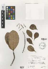 Loranthus raiateensis John W. Moore 620385[1001654]Moore, J.W. 5261927-01-13 French Polynesia, Society Islands, Raiatea, Upper end of 3rd valley south of Faaroa Bay, -16.82666 -151.439587, 140m |
MIN:Plants | 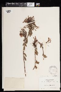 Loranthus verticillatus Ruiz & Pav. 100253[1293487]Bang, Miguel 1391889-00-00 Bolivia, Vicinity of La Paz, 3048m |
MIN:Plants | 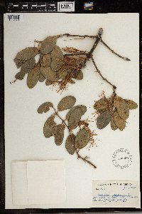 553029[1369979]Sidey, James L. 32061957-07-00 South Africa, Collected Umhlanda Rocks, Natal |
MIN:Plants | 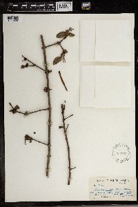 Loranthus natalitius Meisn. 569766[1369980]James L. Sidey 35481961-12-00 South Africa, Natal, Umkomaas Valley |
1
Page 1, records 1-5 of 5
Google Map
Google Maps is a web mapping service provided by Google that features a map that users can pan (by dragging the mouse) and zoom (by using the mouse wheel). Collection points are displayed as colored markers that when clicked on, displays the full information for that collection. When multiple species are queried (separated by semi-colons), different colored markers denote each individual species.