University of Minnesota
http://www.umn.edu/
612-625-5000
http://www.umn.edu/
612-625-5000
Minnesota Biodiversity Atlas
Bell Museum
Dataset: MIN-Plants
Taxa: Lotus
Search Criteria: excluding cultivated/captive occurrences
Bell Museum plants | |
 MIN:Plants |  435564[1077715]Wheeler, Gerald 171921997-08-13 United States, Minnesota, Swift, Swift Co.; Ca. 11.5 mi. NNE of Appleton, E of Rte. 7; NE1/4 SW1/4 Sec. 21 T122N R42W (Fairfield 21);;122N;42W;21, 45.3622732 -95.9424291 |
MIN:Plants |  507912[1077714]Wheeler, Gerald 200171999-06-12 United States, Minnesota, Nicollet, Nicollet County ... Ca. 2.5 mi. SW of St. Peter on Rte. 169, W of road ... SW1/4 Sec. 31 T110N R26W;;110N;26W;31, 44.2873683 -93.9920788 |
MIN:Plants |  Lotus nevadensis (S. Watson) Greene 236110[1077766]Congdon, J. s.n.1897-06-05 United States, California, Mariposa, Glacier Pint Turnpike, Mariposa County;Yosemite National Park;;;, 37.82714 -119.53674 |
MIN:Plants |  454830[1077742]Smith, Welby 206881992-07-08 United States, Minnesota, Goodhue, Dorer Memorial Hardwood State Forest. Goodhue County ... About 3 miles west of Red Wing ... bluff in the Cannon River Valley ... Cannon Valley Trail ... T 113N R 15W SW1/4 of SE1/4 of sec 21. 113N 15W 21, 44.5738907 -92.6194458 |
MIN:Plants |  913750[1077710]Smith, Welby 227641993-07-08 United States, Minnesota, Rock, Rock County...Blue Mounds State Park, about 2 mi north-northeast of Luverne...T 103N R 45W NW1/4 of SW1/4 of Sec 25;Blue Mounds State Park;103N;45W;25, 43.6944444 -96.1888889 |
MIN:Plants | Lotus scoparius (Torrey & A. Gray) Ottley 499340[]Went, F. s.n.1947-09-00 United States, California, San Rafael burn |
MIN:Plants |  Lotus purshianus Clements & E.G.Clements 911728[1077776]Chayka, K. KC-09032009-08-09 United States, Minnesota, Ramsey, Rice Creek Trail County Park. Ramsey County...Rice Creek Trail Regional Park, Shoreview; large prairie in the center of the park, along the dirt trail on the east end, about halfway up the trail. 030N 23W 4, 45.1161111 -93.1744444 |
MIN:Plants |  491144[1077695]Juhnke, C. 319 CMJ FRO1999-06-09 United States, Minnesota, Goodhue, Frontenac State Park. Frontenac State Park Goodhue County ... Ditch along Cty. Rd. 2 about 100 meters north of monument parking lot along Hwy. 61 ... T112N R13W NE SW NW 13. 112N 13W 13, 44.5053595 -92.3190924 |
MIN:Plants |  912491[1077725]Smith, Welby 229331993-07-15 United States, Minnesota, Fillmore, Fillmore County...Along the Root River Trail, about 2 miles west of Lanesboro...T 103N R 10W SE1/4 of SW1/4 of Sec 15;;103N;10W;15, 43.7202778 -92.0197222 |
MIN:Plants |  461947[1077704]Wheeler, Gerald 163121997-06-27 United States, Minnesota, Redwood, Redwood County ... Ca. 3.9 mi. N of Belview on Rte. 7, along roadside ... N1/2 NW1/4 Sec. 20 T 114N R 37W (Swedes Forest 20). 114N 37W 20, 44.664942 -95.3299222 |
MIN:Plants | Lotus crassifolius var. crassifolius (Bentham) Greene 235934[]Congdon, J. s.n.1885-06-00 United States, California, Mariposa, Hite's Cove, Mariposa County;Yosemite National Park;;;, 37.82714 -119.54224 |
MIN:Plants |  900935[1077757]Lee, Michael MDL39872005-06-22 United States, Minnesota, Becker, Becker County...moraine southeast of Collet Lake, two miles south-southeast of Evergreen, 6.5 miles southwest of the town of Wolf Lake...T138N R38W NE1/4 of NE1/4 Sec. 35. 138N 38W 35, 46.7237207 -95.4458403 |
MIN:Plants |  Lotus purshianus Clements & E.G.Clements 508871[1077775]Wheeler, Gerald 177071997-09-05 United States, Minnesota, Renville, Renville County ... W side of Morton, Morton Outcrop complex ... SW1/4 NW1/4 NW1/4 Sec. 31 T113N R34W (Birch Cooley31);;113N;34W;31, 44.5432687 -94.9903271 |
MIN:Plants |  429009[1077700]Wheeler, Gerald 171091997-08-11 United States, Minnesota, Chippewa, Chippewa County ... Ca. 2.2 mi. SE of Granite Falls, E of Pete's Pt. Rd. SE ... W1/2 SE1/4 SW1/4 Sec. 12 T115N R39W;Gneiss Outcrops Scientific Natural Area;115N;39W;12, 44.7815206 -95.4926834 |
MIN:Plants |  Lotus crassifolius var. crassifolius (Bentham) Greene 235932[1077762]Congdon, J. s.n.1885-07-02 United States, California, Mariposa, Yosemite Valley;Yosemite National Park |
MIN:Plants |  918239[1077759]Smith, Welby 223621993-06-08 United States, Minnesota, Carver, Carver County...Carver Park Reserve; about 5 miles west of Chanhassen...T 116N R 24W SE1/4 of NE1/4 of Sec 11;Carver Park Reserve County Park;116N;24W;11, 44.8716667 -93.6644444 |
MIN:Plants |  912535[1077711]Smith, Welby 229261993-07-14 United States, Minnesota, Sibley, Sibley County ... Between TH 19 and the adjacent railroad tracks, about 4 miles west of Gaylord ... T112N R29W NE1/4 of NE1/4 of Sec 4. 112N 29W 4, 44.5427778 -94.3116667 |
MIN:Plants |  Lotus nevadensis (S. Watson) Greene 236100[1077768]Congdon, J. s.n.1883-06-01 United States, California, Mariposa, River Trail to Yosemite Valley, Mariposa County;Yosemite National Park |
MIN:Plants |  433312[1077718]Smith, Welby 171481990-07-04 United States, Minnesota, Pine, Pine Co.; On the Hinckly [sic] Bike Trail where it crosses CSAH 26 at Friesland; T 42N R 21W SE1/4 of SE1/4 of Sec 25 Pine Co.; On the Hinckly [sic] Bike Trail where it crosses CSAH 26 at Friesland; T 42N R 21W SE1/4 of SE1/4 of Sec 25. 042N 21W 25, 46.085556 -92.9327774 |
MIN:Plants |  433418[1077719]Smith, Welby 171221990-06-28 United States, Minnesota, Waseca, Waseca Co.; On the Chicago and Northwestern Railroad right-of-way, about 1.5 miles east of Janesville; Waseca Co.; On the Chicago and Northwestern Railroad right-of-way, about 1.5 miles east of Janesville; T 108N R 24W SW1/4 of SW1/4 of sec 36. 108N 24W 36, 44.1111107 -93.6658325 |
MIN:Plants |  457283[1077692]Haferman, J. 1281995-07-01 United States, Minnesota, Scott, Scott Co. T115N R22W S36 SW of SW. Approx. 0.1 mi N-NE of intersection of State Hwy.13 and Co. Road 44 on N side of high Scott Co. T115N R22W S36 SW of SW. Approx. 0.1 mi N-NE of intersection of State Hwy.13 and Co. Road 44 on N side of highway.. 115N 22W 36, 44.7245862 -93.4090306 |
MIN:Plants |  458632[1077755]Smith, Welby 154391989-06-25 United States, Minnesota, Freeborn, Myre Big Island State Park. Freeborn County...Helmer Myre State Park, about 2 miles southeast of Albert Lea. On 'Big Island' in Albert Lea Lake. In gravel parking lot. SW1/4 NW1/4 sec.19, T 102N R 20W. 102N 20W 19, 43.625 -93.2875 |
MIN:Plants |  459080[1077684]Darveaux, B. s.n.1991-07-15 United States, Minnesota, Steele, Owatonna, Steele Co. Rt 14 heading east off of Hwy 35, near 176 mile marker on left side of road;;107N;20W;, 44.095575 -93.245954 |
MIN:Plants |  459210[1077696]Puchalski, L. 2401993-06-25 United States, Minnesota, Polk, Polk Co.; on county right-of-way; T148N R44W SW1/4 of SE1/4 of Sec 31;;148N;44W;31, 47.5938582 -96.312283 |
MIN:Plants |  463692[1077698]Smith, Welby 212591992-08-05 United States, Minnesota, Olmsted, Bear Cave County Park. Olmsted Co.; Bear Cave County Park, on the west sid eof Stewartville; T 105N R 14W SW1/4 of NE 1/4 of Sec 33 Olmsted Co.; Bear Cave County Park, on the west sid eof Stewartville; T 105N R 14W SW1/4 of NE1/4 of Sec 33. 105N 14W 33, 43.9263878 -92.4958344 |
MIN:Plants |  475127[1077691]Myhre, K. 39151993-06-24 United States, Minnesota, Pine, Pine Co. Located 1/4 mi SW of the Hay Creek Flowage; T42N R16W SW1/4 of SE1/4 of Sec 30;Saint Croix State Forest;042N;16W;30, 46.0915999 -92.4150291 |
MIN:Plants |  475139[1077687]Myhre, K. 38321993-06-14 United States, Minnesota, Pine, Pine Co. Located on the SW shore of Little Tamarack Lake; T42N R17W SE1/4 of NE1/4 of Sec 33;Saint Croix State Forest;042N;17W;33, 46.0772722 -92.4984232 |
MIN:Plants |  475373[1077699]Lee, Michael MDL2281993-07-14 United States, Minnesota, Dakota, Dakota Co.; Apple Valley, Alimagnet Lake; T 115N R 20W SW1/4 of NE1/4 of Sec 20;;115N;20W;20, 44.7535697 -93.2480383 |
MIN:Plants |  506864[1077723]Smith, Welby 170211990-06-25 United States, Minnesota, Steele, Steele Co. Marsh Wren State Wildlife Management Area, about 8 mi SE of Owatonna; T106N R19W NE1/4 of NE1/4 of Sec 14;Marsh Wren Wildlife Management Area;106N;19W;14, 43.9936104 -93.0691681 |
MIN:Plants |  506866[1077722]Smith, Welby 170681990-06-27 United States, Minnesota, Martin, Martin Co. Bright Lake County Park, about 2.5 mi NE of Ceylon; T101N R31W SW1/4 of NE1/4 of Sec 17;;101N;31W;17, 43.5533333 -94.7047195 |
MIN:Plants |  514911[1077685]Smith, Welby 192551991-07-09 United States, Minnesota, Koochiching, Pine Island State Forest. Koochiching County...about 5 miles southwest of Big Falls. Along Hickes Ridge Road, about 0.5 mile north of US Highway 71. Abandoned gravel pit...T 154N R 25W NE1/4 of SW1/4 of sec. 30. 154N 25W 30, 48.1272222 -93.8975 |
MIN:Plants |  515542[1077721]Smith, Welby 168001990-06-12 United States, Minnesota, Lake, Lake Co.; Tetagouch [sic] State Park, about one mile southwest of Illgen City; T 56N R 7W SE1/4 of NW1/4 of Sec 15;North Shore / Tettegouche State Park;056N;07W;15, 47.3375015 -91.2097244 |
MIN:Plants |  515543[1077720]Smith, Welby 168981990-06-20 United States, Minnesota, Dodge, Dodge County...Dodge Center Creek Park. On the north side of Dodge Center Creek, and one mile west of the town of Dodge Center...T 107N R 17W SW1/4 of SW1/4 of Sec 28. 107N 17W 28, 44.0377778 -92.8780556 |
MIN:Plants |  520055[1077688]Smith, Welby 190241991-06-30 United States, Minnesota, Aitkin, Aitkin Co.; Karen Myhre's homestead, about 3.5 mi W-NW of Glen; T46N R26W NE1/4 of NE1/4 of Sec 26 Aitkin Co.; Karen Myhre's homestead, about 3.5 mi W-NW of Glen; T46N R26W NE1/4 of NE1/4 of Sec 26. 046N 26W 26, 46.4444427 -93.5769424 |
MIN:Plants |  520340[1077694]Smith, Welby 209701992-07-16 United States, Minnesota, Pennington, Pennington County...on the W side of County Road 73, about 4.5 miles NW of the center of Thief River Falls...abandoned gravel pit...T154N R44W NE1/4 of NE1/4 of Sec 13. 154N 44W 13, 48.1638889 -96.2405556 |
MIN:Plants |  520474[1077724]Smith, Welby 169791990-06-21 United States, Minnesota, Faribault, Walnut Lake Wildlife Management Area. Fairbault [sic] Co.; Walnut Lake State Wildlife Management Area. At the pubic access at the S side of Walnut Lake; Fairbault [sic] Co.; Walnut Lake State Wildlife Management Area. At the pubic access at the S side of Walnut Lake; T103N R25W SE1/4 of SW1/4 of Sec 35. 103N 25W 35, 43.681159 -93.797567 |
MIN:Plants |  520910[1077756]Smith, Welby 164161989-09-06 United States, Minnesota, Benton, Benton County...on the E bank of the Mississippi River in Rice...NE1/4 NE1/4 sec.36, T38N R32W;;038N;32W;36, 45.7483333 -94.26 |
MIN:Plants |  543530[1077741]Lakela, Olga; Davidson, Donald 216481957-07-24 United States, Minnesota, Lake, Tomahawk Trail, Phoebe River area eastern Lake Co, T63;Boundary Waters Canoe Area Wilderness / Superior National Forest;063N;06W;00, 47.896313 -91.081007 |
MIN:Plants |  553781[1077740]Moore, John 227271955-07-29 United States, Minnesota, Norman, 11 mi E of Perley;;N;;, 47.177509 -96.571096 |
MIN:Plants |  554928[1077754]Moyle, J. s.n.1959-07-01 United States, Minnesota, Itasca, 1 1/2 mi N of Hwy No. 2, leading to Mud Lake near Deer River;;N;;, 47.33064 -93.710626 |
MIN:Plants |  572414[1077705]Moore, John 255141961-06-29 United States, Minnesota, Kittson, roadside ditch 1 mi N of Hallock;;N;;, 48.792517 -96.952627 |
MIN:Plants |  572968[1077737]Stevens, O. 25671962-06-24 United States, Minnesota, Clay, Glyndon;;139N;47W;11, 46.8698948 -96.5786692 |
MIN:Plants |  603990[1077707]Moore, John; Hsi, Yu-tseng [Eugene] 272101967-06-19 United States, Minnesota, Winona, Winona Co, along roadside at Wyattville;;106N;08W;, 43.940796 -91.790151 |
MIN:Plants |  608097[1077738]Moore, John; Moore, Marjorie 272551968-07-26 United States, Minnesota, Houston, Near the upper end of Winnebago Valley;Dorer Memorial Hardwood State Forest;N;;, 43.567611 -91.479467 |
MIN:Plants |  631508[1077734]Richards, Donald; et al. 16911971-06-20 United States, Minnesota, Itasca, Itasca County...along road to Sugar Lake, 6 mi SW of Grand Rapids;;;;, 47.168358 -93.643312 |
MIN:Plants |  645955[1077735]Westkaemper, Remberta s.n.1973-09-00 United States, Minnesota, Stearns, Stearns Co. St. Joseph;;124N;29W;, 45.564083 -94.30917 |
MIN:Plants |  649431[1077726]Gustitus, J. 501973-09-29 United States, Minnesota, Washington, Washington Co. Grant Twp, along Jamaca Ave N;;030N;21W;00, 45.084411 -92.910491 |
MIN:Plants |  678940[1077748]Wheeler, Gerald 50091975-07-25 United States, Minnesota, Cook, Cook Co. Kadunce River Wayside Rest, US Rte 61;North Shore / Superior National Forest;061N;02E;, 47.793559 -90.154756 |
MIN:Plants |  678941[1077743]Wheeler, Gerald 49331975-06-26 United States, Minnesota, Clearwater, Itasca State Park. Lake Itasca. Headwaters parking area at border of lawn;Itasca State Park;143N;36W;, 47.240306 -95.211923 |
MIN:Plants |  681989[1077733]Clemants, Steven 8481977-08-08 United States, Minnesota, Cook, Cook Co.; Kekabic trail and Gunflint Trail, 2.5 mi S of Seagull guard station, T65N, R4W, S27 NE1/4;Superior National Forest;065N;04W;27, 48.0842418 -90.825443 |
MIN:Plants |  687286[1077736]Wheeler, Gerald; Glaser, Paul 17151977-06-20 United States, Minnesota, Itasca, Coll. site no. 58, SW1/4 SW1/4 S33, T56N, R25W; ca 2.5 mi N of Grand Rapids; roadside embankment adjacent to Hwy 38.;;056N;25W;33, 47.2893965 -93.5228883 |
MIN:Plants |  691078[1077739]Sperling, C. 3771976-06-18 United States, Minnesota, Douglas, road shoulder 3 mi S of Garfield;;N;;, 45.897358 -95.491987 |
MIN:Plants |  696585[1077732]Smith, Welby 6491978-07-09 United States, Minnesota, Wright, T122N R27W NE1/4 sec. 3, 45.405752 -94.057057 |
MIN:Plants |  712110[1077753]Smith, Welby 18531979-08-25 United States, Minnesota, Wright, Wright Co.; T122N, R26W, NE1/4 SW1/4 S7, 0.2 mi NE of Co. Hwy 75, 4 mi SE of its jnc with State Hwy 24 in Clearwater, ba Wright Co.; T122N, R26W, NE1/4 SW1/4 S7, 0.2 mi NE of Co. Hwy 75, 4 mi SE of its jnc with State Hwy 24 in Clearwater, bank of Fish Creek between Hwy 75 and Burlington Northern tracks. 122N 26W 7, 45.3904674 -94.0034402 |
MIN:Plants |  712130[1077712]Smith, Welby 18751979-09-02 United States, Minnesota, Wright, W side of Co Hwy 19, ca 0.9 mi N of it's junction with State Hwy 55 in Rockford. SE1/4 of section;;119N;24W;20, 45.0960815 -93.7284222 |
MIN:Plants |  727174[1077750]Herman, J. 1051979-07-17 United States, Minnesota, Norman, Twin Valley Prairie: 5 mi W of Syre, NW1/4 and E1/2 of SW1/4 of S23, T143N, R45W;Twin Valley Prairie Scientific Natural Area;143N;45W;23, 47.2744614 -96.3536656 |
MIN:Plants |  728884[1077751]Herman, J. 2041979-08-28 United States, Minnesota, Mahnomen, Mahnomen Co. Santee Prairie: 3 mi SE of Bejou, S6, 7, T145N, R41W;Santee Prairie Scientific Natural Area / White Earth Indian Reservation;145N;41W;, 47.4051432 -95.9225134 |
MIN:Plants |  732564[1077752]Cross-Cella, J. 951980-06-06 United States, Minnesota, Becker, Zimmerman Prairie: 10 mi W of Ogema, E1/2 SW1/4 S16, T142N, R43W;Zimmerman Prairie [TNC];142N;43W;16, 47.1150258 -96.1414196 |
MIN:Plants |  734589[1077749]Petron, T. 981980-06-10 United States, Minnesota, Clay, Bluestem Prairie: 13 mi E of Moorhead, NE1/4 SW1/4 S23, T139N, R46W;Bluestem Prairie Scientific Natural Area;139N;46W;23, 46.8401941 -96.452227 |
MIN:Plants |  758953[1077744]Smith, Welby 74521982-08-20 United States, Minnesota, Mower, Racine Prairie Scientific Natural Area. Racine Prairie State Scientific and Natural Area, strip adjacent to the E side of US Trunk Hwy 63, ca 2 mi N of Racine, Racine Prairie State Scientific and Natural Area, strip adjacent to the E side of US Trunk Hwy 63, ca 2 mi N of Racine, NE1/4 NE1/4 S22, T104N, R14W. 104N 14W 22, 43.7976425 -92.4992666 |
MIN:Plants |  773331[1077745]Boe, J. 6051979-07-08 United States, Minnesota, Lake of the Woods, Hwy 2 N of Williams, S24, R34W, T163N;;163N;34W;24, 48.9234175 -94.9709894 |
MIN:Plants |  773544[1077747]Boe, J. 3941979-06-26 United States, Minnesota, Lake of the Woods, Brown's Lake, S11, R35W, T159N;;159N;35W;11, 48.6052662 -95.1157807 |
MIN:Plants |  773896[1077746]Boe, J. 4361979-06-28 United States, Minnesota, Lake of the Woods, near jnc Hwy 11, 6 near Pitt, NE1/4 S2, R32W, T160N;;160N;32W;2, 48.7067634 -94.7252901 |
MIN:Plants |  811016[1077731]Vixie, D. 4081979-08-22 United States, Minnesota, Carver, Carver Co. Foxglove Circle, 4 mi W of Excelsior, Chanhassen Twp, Elev. 950 ft.;;116N;23W;, 44.862156 -93.612512 |
MIN:Plants |  815888[1077730]Wheeler, Gerald 110101988-06-28 United States, Minnesota, Wilkin, ca 6 mi N of Rothsay; E of Rte 173, W1/2 SW1/4 S24, T136N, R45W (Prairie View Twp);;136N;45W;24, 46.5804999 -96.2918372 |
MIN:Plants |  816003[1077693]Wheeler, Gerald 122481988-09-20 United States, Minnesota, Traverse, ca 4.5 mi SW of Wheaton; N of Rte 27, NW1/4 NE1/4 S33, T127N, R47W (Lake Twp);;127N;47W;33, 45.767024 -96.5832922 |
MIN:Plants |  816222[1077728]Bender, J. s.n.1986-07-16 United States, Minnesota, Washington, Belwin Outdoor Education Laboratory;Belwin Outdoor Education Laboratory;028N;20W;, 44.9271878 -92.7918522 |
MIN:Plants |  816258[1077729]Wheeler, Gerald 116821988-08-11 United States, Minnesota, Norman, ca 9 mi NNE of Gary; E of Rte 34, along roadside and access road, NW1/4 SW1/4 S6, T146N, R43W (Bear Park Twp);;146N;43W;6, 47.4924642 -96.184947 |
MIN:Plants |  816330[1077706]Wheeler, Gerald 115391988-07-27 United States, Minnesota, Lac Qui Parle, Bellingham (S side); W of Rte 75, along roadside, E1/2 SE1/4 S9, T119N, R45W (Perry Twp);;119N;45W;9, 45.1306617 -96.2977624 |
MIN:Plants |  816331[1077727]Wheeler, Gerald 115821988-07-28 United States, Minnesota, Big Stone, ca 10.5 mi N of Correll; SW of Rte 10, between lake and road, NE1/4 S14, T122N, R44W (Artichoke Twp);;122N;44W;14, 45.3771471 -96.1481275 |
MIN:Plants | 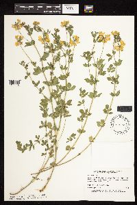 829285[1077716]Myhre, K. 21761992-06-08 United States, Minnesota, Cass, Cass Co. Located 1/2 mi S of the town of Pine River; T137N R29W NW1/4 of SW1/4 of Sec 6;;137N;29W;6, 46.7113578 -94.3984754 |
MIN:Plants | 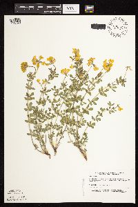 829293[1077690]Myhre, K. 20431992-06-01 United States, Minnesota, Cass, Cass Co. Located on the NE side of the town of Hackensack; T140N R30W NW1/4 of NE1/4 of Sec 19;;140N;30W;19, 46.9289207 -94.5228594 |
MIN:Plants | 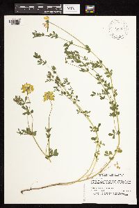 829664[1077686]Nation, R. 11621993-07-14 United States, Minnesota, Wabasha, Wabasha Co. Carley State Park, N side of North Fork of Zumbro River; T108N R11W NE1/4 of SW1/4 of Sec 32;Carley State Park;108N;11W;32, 44.1144882 -92.1693661 |
MIN:Plants | 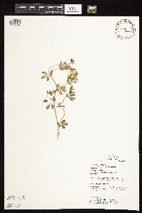 833515[1077697]Juhnke, C. 1181991-06-15 United States, Minnesota, Fillmore, Forestville State Park. Fillmore Co. T102N R12W Sec.24 NE NE NW; near interpretive center;Forestville State Park;102N;12W;24, 43.6234111 -92.2191515 |
MIN:Plants |  Lotus purshianus Clements & E.G.Clements 139139[1077787]Ballard, C. 31061901-08-13 United States, Minnesota, Clay, Muskoda [historic RR station near Hawley];;139N;45W;17, 46.8545484 -96.3967683 |
MIN:Plants |  Lotus purshianus Clements & E.G.Clements 139172[1077780]Moyer, Lycurgus s.n1903-08-21 United States, Minnesota, Big Stone, Big Stone Lake;;117N;40W;, 45.416956 -96.636957 |
MIN:Plants |  Lotus purshianus Clements & E.G.Clements 139173[1077779]Moyer, Lycurgus 1903-08-20 United States, Minnesota, Big Stone, Big Stone Lake;;117N;40W;, 45.416956 -96.636957 |
MIN:Plants |  Lotus purshianus Clements & E.G.Clements 139174[1077778]Moyer, Lycurgus 1899-07-00 United States, Minnesota, Chippewa, Montevideo;;117N;40W;, 44.953148 -95.715397 |
MIN:Plants |  Lotus purshianus Clements & E.G.Clements 139175[1077781]Menzel, Max s.n.1895-06-00 United States, Minnesota, Pipestone, Pipestone [assuming the quarry area; town generally noted as "Pipestone City" by collector];Pipestone National Monument;106N;46W;01, 44.01585 -96.31767 |
MIN:Plants |  Lotus purshianus Clements & E.G.Clements 139176[1077784]Menzel, Max s.n.1895-06-00 United States, Minnesota, Pipestone, Pipestone [assuming the quarry area; town generally noted as "Pipestone City" by collector];Pipestone National Monument;106N;46W;01, 44.01585 -96.31767 |
MIN:Plants |  Lotus purshianus Clements & E.G.Clements 139177[1077792]Ballard, C. 2771 1/21900-08-00 United States, Minnesota, Kittson, Hallock;;161N;49W;, 48.76042 -96.99613 |
MIN:Plants |  Lotus purshianus Clements & E.G.Clements 139178[1077782]Menzel, Max s.n.1895-06-00 United States, Minnesota, Pipestone, Pipestone [assuming the quarry area; town generally noted as "Pipestone City" by collector];Pipestone National Monument;106N;46W;01, 44.01585 -96.31767 |
MIN:Plants |  Lotus purshianus Clements & E.G.Clements 139179[1077796]Sheldon, Edmund S1893-09-00 United States, Minnesota, Big Stone, Graceville;;N;;, 45.5790853 -96.421701 |
MIN:Plants |  Lotus purshianus Clements & E.G.Clements 139180[1077791]Sheldon, Edmund s.n.1893-09-00 United States, Minnesota, Traverse, Brown's Valley;;N;;, 45.595239 -96.833407 |
MIN:Plants |  Lotus purshianus Clements & E.G.Clements 139181[1077797]MacMillan, C. s.n.1890-07-00 United States, Minnesota, Renville, Morton;;113N;34W;, 44.552818 -94.984782 |
MIN:Plants |  Lotus purshianus Clements & E.G.Clements 139182[1077785]Sheldon, Edmund S72251892-09-00 United States, Minnesota, Traverse, Wheaton;;N;;, 45.804405 -96.499233 |
MIN:Plants |  Lotus purshianus Clements & E.G.Clements 370813[1077790]Moore, John; et al. 133881940-06-28 United States, Minnesota, Nicollet, Fort Ridgley State Park;Fort Ridgely State Park;111N;32W;06, 44.443975 -94.7414917 |
MIN:Plants |  Lotus purshianus Clements & E.G.Clements 373562[1077788]Lakela, Olga 51861942-08-30 United States, Minnesota, Pine, rr embankmant near Kerrick, Hwy 23;;N;;, 46.339545 -92.586868 |
MIN:Plants |  Lotus purshianus Clements & E.G.Clements 434988[1077799]Abbott, Robinson s.n.1961-08-20 United States, Minnesota, Big Stone, Big Stone Co.; N.W. corner, junction rts. 28 & 75, Graceville;;124N;46W;, 45.5213376 -96.4419661 |
MIN:Plants |  Lotus purshianus Clements & E.G.Clements 505804[1077771]Schimpf, D. 1021982-08-27 United States, Minnesota, Pine, Pine Co. T45N, R18W, S35. On & at foot of settp SE-facing railroad bank in Kerrick;;045N;18W;35, 46.3386214 -92.5843182 |
MIN:Plants |  Lotus purshianus Clements & E.G.Clements 520409[1077769]Dana, R. s.n.1977-08-07 United States, Minnesota, Renville, Renville Co.; W side of Morton;;113N;35W;, 44.552818 -94.989074 |
MIN:Plants |  Lotus purshianus Clements & E.G.Clements 541491[1077789]Scharf, J. s.n.1956-07-27 United States, Minnesota, Lyon, 3 mi N and 1 mi W of Balaton, edge of state owned wetland;;N;;, 44.276743 -95.892471 |
MIN:Plants |  Lotus purshianus Clements & E.G.Clements 592000[1077795]Moore, John; et al. 267561965-07-18 United States, Minnesota, Pipestone, Pipestone County...above the ledges west of the rr tracks, Pipestone National Monument;Pipestone National Monument;106N;46W;, 44.005 -96.312224 |
MIN:Plants |  Lotus purshianus Clements & E.G.Clements 668060[1077777]Hsi, Yu-tseng [Eugene] 12091975-09-22 United States, Minnesota, Lyon, near Ghent;;N;;, 44.512738 -95.891137 |
MIN:Plants |  Lotus purshianus Clements & E.G.Clements 691614[1077786]Morley, T.; et al. 14101978-08-07 United States, Minnesota, Redwood, Redwood Co. Gales Twp, T110N, R39, ca the N1/2 N1/2 NW1/4 S17, S side of low ridge;;110N;39W;17, 44.3338606 -95.563976 |
MIN:Plants |  Lotus purshianus Clements & E.G.Clements 717945[1077794]Morley, T. 14911980-09-01 United States, Minnesota, Crow Wing, strip between hwy 371 and rr ca 2 mi S of Brainerd, T133N, R31W, S1/4 S2;;133N;31W;2, 46.323495 -94.221085 |
MIN:Plants |  Lotus purshianus Clements & E.G.Clements 728375[1077798]Dana, R. s.n.1980-07-30 United States, Minnesota, Lincoln, Lincoln County...Hole-in-the-Mountain Preserve, ca 1.7 mi S of Lake Benton, T109N, R45W, S19, SE1/4;Hole-in-the-Mountain Prairie, The Nature Conservancy;109N;45W;19, 44.233753 -96.3121788 |
MIN:Plants |  Lotus purshianus Clements & E.G.Clements 739646[1077793]Converse, C. 20431982-08-12 United States, Minnesota, Chippewa, Chippewa / Swift Cos. Chippewa Prairie: T119N, R43W SW1/4 NE1/4 S13;Chippewa Prairie, The Nature Conservancy;119N;43W;13, 45.1102347 -95.9967661 |
MIN:Plants |  Lotus purshianus Clements & E.G.Clements 763542[1077783]Lugger, O. 68201900-09-00 United States, Minnesota, Big Stone, Graceville;;124N;46W;03, 45.5790853 -96.421701 |
MIN:Plants |  Lotus purshianus Clements & E.G.Clements 812576[1077773]Wheeler, Gerald 121951988-09-11 United States, Minnesota, Big Stone, Big Stone Co.; ca 1.2 mi NW of Barry; ca 0.3 mi E of Rte 57, SE1/4 NW1/4 S8, T124N, R47W (Toqua Twp);Barry Lake Wildlife Management Area;124N;47W;8, 45.5656911 -96.586118 |
Google Map
Google Maps is a web mapping service provided by Google that features a map that users can pan (by dragging the mouse) and zoom (by using the mouse wheel). Collection points are displayed as colored markers that when clicked on, displays the full information for that collection. When multiple species are queried (separated by semi-colons), different colored markers denote each individual species.