University of Minnesota
http://www.umn.edu/
612-625-5000
http://www.umn.edu/
612-625-5000
Minnesota Biodiversity Atlas
Bell Museum
Dataset: MIN-Plants
Taxa: Maclura
Search Criteria: excluding cultivated/captive occurrences
1
Page 1, records 1-14 of 14
Bell Museum plants | |
 MIN:Plants | Maclura pomifera (Rafinesque) C.K. Schneider 430195[]Arboretum, Cary 73-451973-00-00 United States, District of Columbia, Washington |
MIN:Plants | Maclura pomifera (Rafinesque) C.K. Schneider 430197[]US Nat. Arboretum staff 1201974-00-00 United States, District of Columbia, Washington |
MIN:Plants | Maclura pomifera (Rafinesque) C.K. Schneider 430196[]US Nat. Arboretum staff 1401978-00-00 United States, Ohio, Hamilton, Hamilton Co. |
MIN:Plants | Maclura tinctoria NULL 939770[]P 632011-07-07 Costa Rica, Guanacaste, Liberia, , 10.84 -85.61, 320m |
MIN:Plants |  Maclura cochinchinensis (Lour.) Corner 914737[]Weiblen, G.D. & Binatang Research Center WP1D01772006-07-10 Papua New Guinea, Madang, Wanang Village, -5.2373 145.177183, 115m |
MIN:Plants |  Maclura cochinchinensis (Lour.) Corner 914732[]Weiblen, G.D. & Binatang Research Center WP2E12942006-09-12 Papua New Guinea, Madang, Wanang Village, -5.2373 145.177183, 115m |
MIN:Plants |  Maclura cochinchinensis (Lour.) Corner 914733[]Weiblen, G.D. & Binatang Research Center WP2E25882006-09-07 Papua New Guinea, Madang, Wanang Village, -5.2373 145.177183, 115m |
MIN:Plants |  Maclura cochinchinensis (Lour.) Corner 914699[]Weiblen, G.D. & Binatang Research Center WP3B05922007-07-02 Papua New Guinea, Madang, Wanang Village, -5.2373 145.177183, 115m |
MIN:Plants | 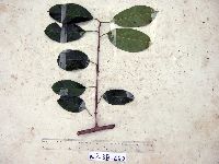 Maclura cochinchinensis (Lour.) Corner 914738[]Weiblen, G.D. & Binatang Research Center WP3B06202007-06-28 Papua New Guinea, Madang, Wanang Village, -5.2373 145.177183, 115m |
MIN:Plants | 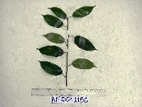 Maclura cochinchinensis (Lour.) Corner 914739[]Weiblen, G.D. & Binatang Research Center WP5D11862007-05-18 Papua New Guinea, Madang, Wanang Village, -5.2373 145.177183, 115m |
MIN:Plants | 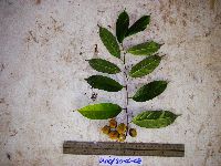 Maclura cochinchinensis (Lour.) Corner 922102[]Ctvrtecka, R. 12512008-06-30 Papua New Guinea, Madang, Wanang Village, -5.23088 145.182, 115m |
MIN:Plants | Maclura tinctoria NULL 431622[]Weiblen, G.D. GW14962001-10-21 Peru, Cocha Cashu, Manu National Park, -7.983333 -74.683333, 153m |
MIN:Plants | Maclura cochinchinensis (Lour.) Corner 431312[]Weiblen, G.D. GW11092000-05-02 Papua New Guinea, Madang, Baiteta Forest, Madang, -5.133333 145.75, 25m |
MIN:Plants | 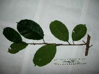 Maclura cochinchinensis (Lour.) Corner 903989[] GW23872005-03-31 Papua New Guinea, Madang, Morox village, near Yoro, Bogia, -4.266667 144.966667, 60m |
1
Page 1, records 1-14 of 14
Google Map
Google Maps is a web mapping service provided by Google that features a map that users can pan (by dragging the mouse) and zoom (by using the mouse wheel). Collection points are displayed as colored markers that when clicked on, displays the full information for that collection. When multiple species are queried (separated by semi-colons), different colored markers denote each individual species.