University of Minnesota
http://www.umn.edu/
612-625-5000
http://www.umn.edu/
612-625-5000
Minnesota Biodiversity Atlas
Bell Museum
Dataset: MIN-Plants
Taxa: Marattia
Search Criteria: excluding cultivated/captive occurrences
1
Page 1, records 1-29 of 29
Bell Museum plants | |
 MIN:Plants | 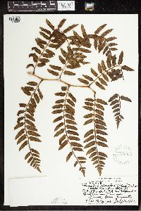 Marattia douglasii (C. Presl) Baker 569860[1342053]Degener, Otto 276181961-07-16 United States, Hawaii, Hawaii, End of Route 148A northeast of Kilauea, Hawaii;Hawaii Volcanoes National Park;;;, 19.4 -155.3 |
MIN:Plants | 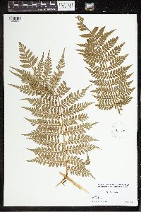 Marattia alata Sw. 931799[1342041]Lawrence, Donald B. s.n.1932-07-15 Jamaica, Portland Gap, 18.04796 -76.59667 |
MIN:Plants | 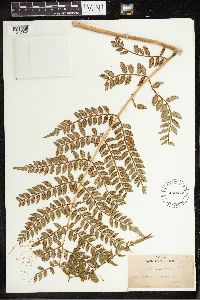 Marattia alata Sw. 452472[1342042]York, H.H. s.n.1910-05-30 Jamaica, Morce's Gap, 18.187177 -77.270834 |
MIN:Plants | 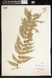 Marattia alata Sw. 50008[1342043]Clute, Willard N. 1791900-02-15 Jamaica, Morce's Gap, 18.090603 -76.653539, 1524m |
MIN:Plants |  Marattia alata Sw. 521959[1342044]Shreve, Forrest s.n.1903-04-25 Jamaica, Morce's Gap; B.W.I., 18.09118 -76.659019 |
MIN:Plants |  Marattia alata Sw. 220426[1342045]York, H.H. s.n.1910-05-30 Jamaica, Morce's Gap, 18.187177 -77.270834 |
MIN:Plants |  Marattia alata Sw. 50007[1342046]Pringle, C.G. 102991906-09-08 Mexico, Puebla, barranca below Honey Station, 20.25 -98.216667, 1676m |
MIN:Plants |  Marattia alata Sw. 50009[1342047]Bang, Miguel 2393 Bolivia, -17 -65 |
MIN:Plants | 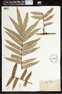 Marattia cicutifolia Kaulf. 452467[1342048]Durand, E.J. s.n. Brazil, Rio, -22.875113 -43.277548 |
MIN:Plants | 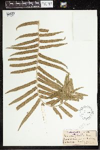 50010[1342049]Wood, J.M. s.n.1890-02-00 South Africa, Noodsberg; Nalalia [?], -29.41359 30.850591, 4500m |
MIN:Plants | 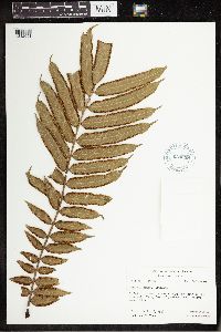 Marattia cincta Copel. 620098[1342051]Moore, John W. 138B1926-09-25 French Polynesia, Raiatea. E path to Mt. Temehani, -16.82666 -151.439587 |
MIN:Plants | 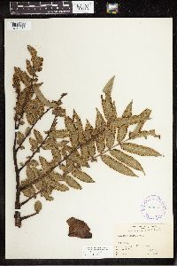 Marattia cincta Copel. 289662[1342052]Grant, Martin L. 52031931-01-29 French Polynesia, Raiatea, Avera, Temehani, -16.82666 -151.439587, 491m |
MIN:Plants | 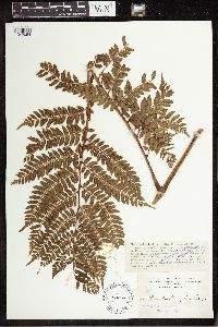 Marattia douglasii (C. Presl) Baker 50011[1342054]Heller, A.A. 27701895-08-30 United States, Hawaii, Kaui. On Kaholuamanoa above Waimea, 21.957069 -159.668926 |
MIN:Plants | 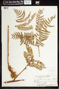 Marattia douglasii (C. Presl) Baker 364911[1342055]Topping, D. L. 38371935-10-06 United States, Hawaii, Waimano, Oahu, 21.440833 -157.910833 |
MIN:Plants | 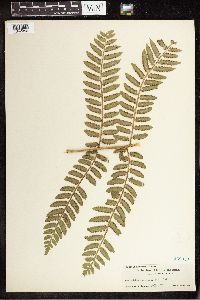 Marattia douglasii (C. Presl) Baker 268053[1342056]Hapeman, H. s.n.1908-04-28 United States, Hawaii, Oahu, 21.4333 -157.9667 |
MIN:Plants | 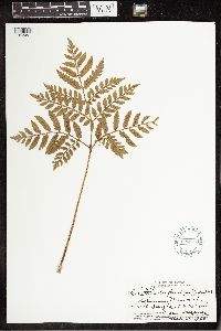 Marattia douglasii (C. Presl) Baker 606817[1342057]Degener, Otto 306991966-05-26 United States, Hawaii, Kulani, 19.5167 -155.3, 1600m |
MIN:Plants | 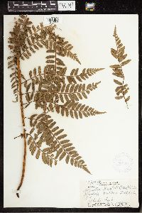 Marattia douglasii (C. Presl) Baker 368515[1342058]Topping, D. L. 36661933-08-13 United States, Hawaii, Waiahole - Waikaue Trail, Oahu |
MIN:Plants | 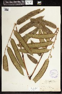 Marattia grantii Copel. 289664[1342059]Grant, Martin L. 53231931-02-07 French Polynesia, Huahine, Maeva District, Matoereere, -16.700891 -150.987007, 521m |
MIN:Plants | 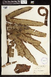 Marattia grantii Copel. 289663[1342060]Grant, Martin L. 51721931-01-25 French Polynesia, Tahaa; District: Ruutia: Mt. Ohiri, -16.631266 -151.521691, 475m |
MIN:Plants | 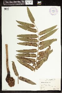 289658[1342061]Grant, Martin L. 39131930-07-02 French Polynesia, Tahiti, Teahupoo District, Ronui, -17.846451 -149.266821, 605m |
MIN:Plants | 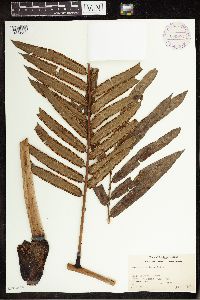 290074[1342062]Grant, Martin L. 40891930-09-06 French Polynesia, Tahiti, Papenoo District, Ana Pua, -17.5 -149.416667 |
MIN:Plants | 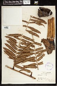 289660[1342063]Grant, Martin L. 42271930-09-21 French Polynesia, Tahiti, Tahiti; Dist.: Papenoo: Orofena, -17.633333 -149.45, 735m |
MIN:Plants | 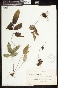 270144[1342064]Leland, B. 371909-10-00 French Polynesia, Tahiti, Tahiti, district of Papara, -17.733333 -149.5 |
MIN:Plants | 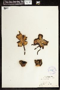 289661[1342065]Grant, Martin L. 45451930-11-15 French Polynesia, Tahiti, Hitiaa Distict, Puunui, -17.633333 -149.366667, 305m |
MIN:Plants | 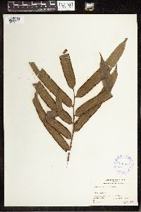 289659[1342066]Grant, Martin L. 42191930-09-21 French Polynesia, Tahiti, Tahiti, Papenoo District, Orofena, -17.598203 -149.442073, 838m |
MIN:Plants | Marattia cicutifolia Kaulf. []Museu Nacional 1875-00-00 Brazil, Near Rio de Janeiro |
MIN:Plants | 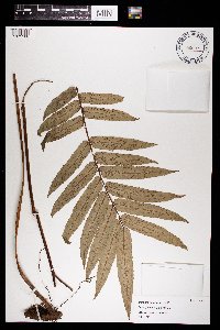 Marattia cicutifolia Kaulf. 969579[1371186]Museu Nacional s.n.1875-00-00 Brazil, Near Rio de Janeiro |
MIN:Plants | 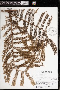 971230[1394707]W. Takeuchi 191772005-04-28 Papua New Guinea, Southern Highlands, ridge complex W of the Hides 3 helipad/basecamp; -5.949167 142.742222, -5.949167 142.742222, 2300m |
MIN:Plants | 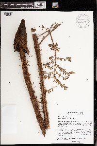 971231[1394708;1394709;1394710;1394711]W. Takeuchi 191772005-04-28 Papua New Guinea, Southern Highlands, ridge complex W of the Hides 3 helipad/basecamp; -5.949167 142.742222, -5.949167 142.742222, 2300m |
1
Page 1, records 1-29 of 29
Google Map
Google Maps is a web mapping service provided by Google that features a map that users can pan (by dragging the mouse) and zoom (by using the mouse wheel). Collection points are displayed as colored markers that when clicked on, displays the full information for that collection. When multiple species are queried (separated by semi-colons), different colored markers denote each individual species.