University of Minnesota
http://www.umn.edu/
612-625-5000
http://www.umn.edu/
612-625-5000
Minnesota Biodiversity Atlas
Bell Museum
Dataset: MIN-Plants
Taxa: Onoclea
Search Criteria: excluding cultivated/captive occurrences
Bell Museum plants | |
 MIN:Plants | 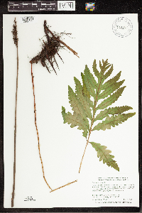 911087[1342729]Smith, Welby 284692000-05-30 United States, Minnesota, Olmsted, Nelson Fen Wildlife Management Area. Olmsted County... Nelson Fen State Wildlife Management Area. About 2 miles S-SE of Rock Dell... T105N R15W SW1/4 of SE1/4 of Sec 16. 105N 15W 16, 43.8947222 -92.6255556 |
MIN:Plants | 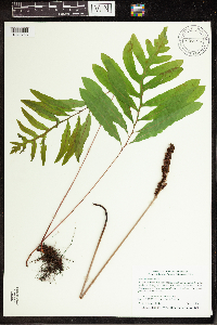 907794[1342763]Smith, Welby 308852008-06-12 United States, Minnesota, Benton, Sartell Wildlife Management Area. Benton County ... Sartell State Wildlife Management Area, about 5 miles southeast of Royalton ... Little Rock Creek ... T38N R31W NW1/4 of SW1/4 of Sec 15. 038N 31W 15, 45.7838889 -94.1927778 |
MIN:Plants | 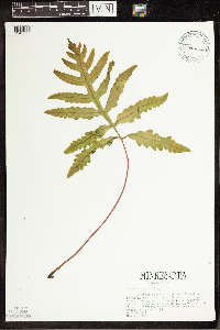 508161[1342692]Kaul, R.; et al. 51741986-05-09 United States, Minnesota, Steele, Steele County...near Straight River, Kaplan's Woods, Owatonna.;;107N;20W;, 44.0833 -93.2167 |
MIN:Plants | 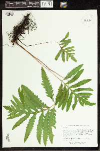 910060[1342734]Lee, Michael MDL42002006-06-01 United States, Minnesota, Wadena, Wadena County ... Along the Crow Wing River four miles south-southwest of Oylen, one mile south-southeast of the Knob Hill campground ... T135N R33W SW1/4 of SW1/4 of NE1/4 Sec.11 (near center of Sec.11). 135N 33W 11, 46.499962 -94.807535 |
MIN:Plants |  911047[1342731]Smith, Welby 289042000-08-05 United States, Minnesota, Anoka, Anoka County...Pioneer Path [sic] City Park in Blaine...T 31N R 23W SE1/4 of SE1/4 of sec 4;;031N;23W;04, 45.1991667 -93.2075 |
MIN:Plants |  508157[1342691]Kaul, R. 57671987-05-24 United States, Minnesota, Steele, Steele Co. ... between the railroad and US Highway 218 just southeat of Owatonna.;;107N;20W;, 44.0833 -93.2167 |
MIN:Plants |  911397[1342733]Smith, Welby 289632000-08-10 United States, Minnesota, Aitkin, Solana State Forest. Aitkin County...On north side of Co Hwy 2, 1.2 miles east of jct with State Hwy 65 in Pliny...T 45N R 23W SE1/4 of SW1/4 of Sec 34. 045N 23W 34, 46.3333333 -93.2322222 |
MIN:Plants |  485446[1342929]Redfield, John s.n.1892-09-06 United States, Maine, Hancock, Mount Desert Island ... near Seal Harbor;Acadia National Park;;;, 44.350732 -68.24411 |
MIN:Plants | 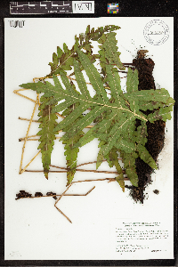 905789[1342760]Smith, Welby 283051999-09-10 United States, Minnesota, Pine, Pine County...Banning State Park, about 3 miles SW of Askov...along the Kettle River...T43N R20W NE1/4 of SW1/4 Sec 35;Banning State Park;043N;20W;35, 46.1630556 -92.8383333 |
MIN:Plants | 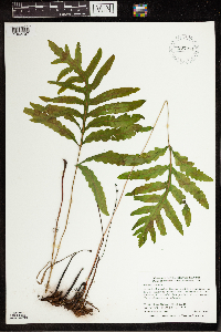 907271[1342797]Smith, Welby 284812000-05-31 United States, Minnesota, Houston, Houston County...About 3 miles south of Houston...T 103N R 6w NW1/4 of NE1/4 of Sec 16;Dorer Memorial Hardwood State Forest;103N;06W;16, 43.7316667 -91.5583333 |
MIN:Plants | 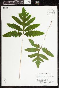 897500[1342742]Smith, Welby 292202001-06-27 United States, Minnesota, Lake, Lake County ... Crosby-Manitou State Park, about 3 air miles from Lake Superior ... T58N R6W NW1/4 of SW1/4 of Sec 28;Crosby Manitou State Park / North Shore;058N;06W;28, 47.4772222 -91.105 |
MIN:Plants | 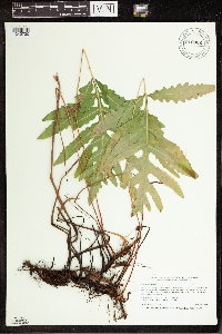 910902[1342730]Smith, Welby 244651994-06-21 United States, Minnesota, Isanti, Lyndon Cedarglade County Park. Isanti County...Lyndon Cedarglade Park, about 1.75 miles north of the Anoka-Isanti County line...T 34N R 25W SW1/4 of NE1/4 of Sec 13. 034N 25W 13, 45.4372222 -93.3958333 |
MIN:Plants | 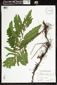 907701[1342769]Smith, Welby 287682000-06-21 United States, Minnesota, Pine, Pine County ... St. Croix State Park; where Sand Creek joins the St. Croix River ... T40N R18W SE1/4 of SW1/4 of Sec 19;Saint Croix State Park;040N;18W;19, 45.9322222 -92.64 |
MIN:Plants | 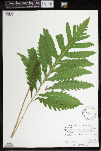 915852[1342612]Anderson, Derek 11812009-06-17 United States, Minnesota, Dodge, Dodge County...About 2.5 km northeast of Concord and about 2.5 km southwest of Berne on the Middle Fork Zumbro River...T108N, R16W, SENW18. T108N R16W S18, 44.15528 -92.789125 |
MIN:Plants | 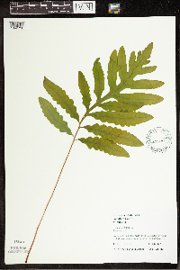 455597[1342756]Juhnke, C. 252 CMJ FRO1999-05-19 United States, Minnesota, Goodhue, Frontenac State Park Goodhue County ... south of interpretive area ...T112N R13W SE NE SE 3;Frontenac State Park;112N;13W;03, 44.534992 -92.358902 |
MIN:Plants | 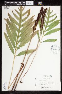 508177[1311361]Kaul, R. 20491985-05-26 United States, Minnesota, Steele, Steele County...along US Hwy 218 ca 1 mile southeast of Owatonna;;107N;20W;, 44.0833 -93.2167 |
MIN:Plants |  911046[1342732]Smith, Welby 284912000-06-05 United States, Minnesota, Goodhue, Perched Valley Wildlife Management Area. Goodhue County...Perched Valley State Wildlife Management Area, about 2.5 miles west of Frontenac...T 112N R 13W NW1/4 of SW1/4 of Sec 8. 112N 13W 8, 44.5172222 -92.4063889 |
MIN:Plants |  916885[1342695]Smith, Welby 223361993-06-08 United States, Minnesota, Carver, Carver County...Carver Park Reserve; about 5 miles west of Chanhassen...T 116N R 24W SE1/4 of NE1/4 of Sec 11;Carver Park Reserve County Park;116N;24W;11, 44.8716667 -93.6644444 |
MIN:Plants |  488270[1311358]Cholewa, A. 26412003-04-29 United States, Minnesota, Anoka, Anoka County, Blaine, 121st Ave and Aberdeen, small stormwater temporary retention area. T31N R23W Sec 8;;031N;23W;08, 45.189899 -93.234832 |
MIN:Plants |  909168[1342723]Smith, Welby; et al. 310322008-07-22 United States, Minnesota, Lake, Boundary Waters Canoe Area Wilderness / Superior National Forest. Lake County...In a bay at the southeast end of Fourtown Lake in the Boundary Waters Canoe Area Wilderness, Superior National Forest ... T65N R11W NW1/4 of NE1/4 of Sec 31. 065N 11W 31, 48.0763889 -91.785 |
MIN:Plants |  908449[1342762]Smith, Welby 309782008-07-04 United States, Minnesota, Hennepin, Hennepin County...Elm Creek Park Reserve, about 4 miles southwest of Anoka...T 120N R 22W SE1/4 of SE1/4 of Sec 34;Elm Creek Park Reserve County Park;120N;22W;34, 45.155 -93.4455556 |
MIN:Plants |  906420[1342815]Smith, Welby 281731999-08-28 United States, Minnesota, Pine, Pine Conty...Where Hwy 18 crosses the inlet to Big Pine Lake, about 6 miles west of Finlayson...T 43N R 21W SW1/4 of SW1/4 of Sec 8. 043N 21W 8, 46.22 -93.0291667 |
MIN:Plants |  520842[1342693]Sutherland, David; et al. 32001972-06-26 United States, Minnesota, Rice, Rice County: Lake Mazaska along Hwy 21, W. of Faribault.;;110N;21W;, 44.294964 -93.268827 |
MIN:Plants |  919326[1342726]Cholewa, A. 27412010-06-24 United States, Minnesota, Pine, Access road 1/4-1/2 mile from County Road 128 (Beroun Road). approx. center along section line.;Chengwatana State Forest;039N;19W;02, 45.9027778 -92.8108333 |
MIN:Plants | 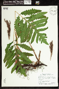 907786[1342766]Smith, Welby 309022008-06-12 United States, Minnesota, Morrison, Rice-Skunk Lake Wildlife Management Area. Morrison County ... Rice-Skunk Lake State Wildlife Management Area, about 7 miles southeast of Little Falls ... T40N R31W SE1/4 of NW1/4 of Sec 32. 040N 31W 32, 45.9222222 -94.2344444 |
MIN:Plants | 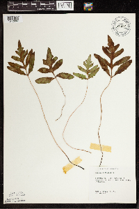 101224[1342834]Tweed, A. 77-1461977-07-29 United States, Minnesota, Beltrami, On co. line 13 mi N of Waskish;Red Lake Peatland Scientific Natural Area;156N;30W;6, 48.308417 -94.555027 |
MIN:Plants | 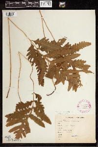 265416[1342832]Goldsmith, G. G2911912-00-00 United States, Minnesota, Rice, Northfield;;N;;, 44.458298 -93.161604 |
MIN:Plants | 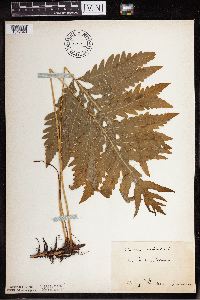 270421[1342649]Gunderson, Harvey s.n.1940-06-23 United States, Minnesota, Lake, Two Harbors;;N;;, 47.583104 -91.421915 |
MIN:Plants |  275785[1342634]Moyle, J. 851930-06-29 United States, Minnesota, Clearwater, Itasca Park. Clearwater Co.; 1/4 mi E of Campus [Univ. of Minn. Bio. Sta.]; SW SW 1 T143 R36;Itasca State Park;143N;36W;1, 47.232294 -95.180237 |
MIN:Plants | 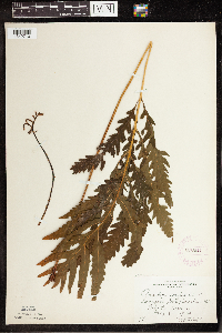 276911[1342710]Huff, N. 961914-07-16 United States, Minnesota, Lake, North Kawishiwi Riv, Lake Co.;Superior National Forest;N;;, 47.583104 -91.421915 |
MIN:Plants | 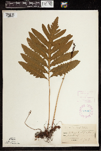 278240[1342830]Roberts, Thomas s.n.1884-07-13 United States, Minnesota, Ramsey, Battle Creek, St. Paul;Battle Creek County Park;028N;22W;, 44.940556 -93.014213 |
MIN:Plants | 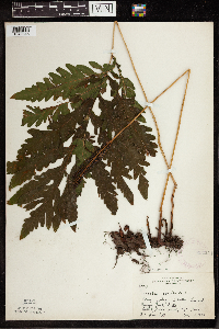 282224[1342846]Rosendahl, C. 63331930-08-29 United States, Minnesota, Cook, Between Les [or Leo?] and Hungry Jack Lake;Superior National Forest;064N;01W;, 48.058252 -90.43604 |
MIN:Plants | 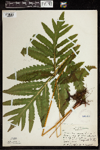 282810[1342844]Butters, F.; Buell, Murray 3931932-07-10 United States, Minnesota, Cook, Cook Co.; Cross R. near bridge on rd. to Seagull Lake;Superior National Forest;065N;04W;, 46.4332 -94.3408 |
MIN:Plants | 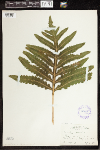 291881[1342712]Fryklund, P. s.n.1924-09-01 United States, Minnesota, Roseau, Roseau Co. On county line of Lake of the Woods Co.;;N;;, 48.830845 -95.124706 |
MIN:Plants |  336644[1342812]Lakela, Olga 17371936-08-19 United States, Minnesota, Saint Louis, Bayside, Sec.19; Duluth;;N;;, 46.783273 -92.106579 |
MIN:Plants |  345528[1342720]Lakela, Olga 23471937-09-04 United States, Minnesota, Saint Louis, N slope of Hunter's Hill; Duluth;;N;;, 46.783273 -92.106579 |
MIN:Plants |  345877[1342721]Lakela, Olga 2164b1937-08-07 United States, Minnesota, Saint Louis, St. Louis River at the bridge on Vermilion Trail 3 mi from Palo, St. Louis Co.;;057N;15W;, 48.2667 -92.4 |
MIN:Plants |  354822[1342738]Barrows, Vera 341939-06-26 United States, Minnesota, Saint Louis, S Drive, Virginia;;N;;, 47.52326 -92.536571 |
MIN:Plants | 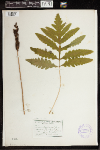 355800[1342833]Garrison, O. s.n.1880-08-15 United States, Minnesota, Prairie River Falls;;;;, 46.771058 -93.229389 |
MIN:Plants | 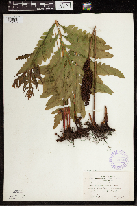 370128[1342785]Moore, John; et al. 141291941-05-25 United States, Minnesota, Carlton, S bank of Moose Horn River, Barnum, Carlton Co.;;;;, 46.503029 -92.690479 |
MIN:Plants | 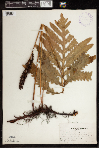 370651[1342822]Moore, John; Moore, Marjorie 136211940-09-28 United States, Minnesota, Ramsey, [Round] Lake, NE1/4 of Sec.21, Mounds View Twp.; Ramsey Co.;;030N;23W;21, 45.075032 -93.173925 |
MIN:Plants | 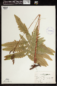 372482[1342827]Moore, John; et al. 145461941-06-15 United States, Minnesota, Red Lake, Clearwater River, 1/2 mi N of Plummer, on Hwy.59, Red Lake Co.;;151N;42W;, 47.924071 -96.042608 |
MIN:Plants |  374008[1342831]Linnaean Club, U of M, 251939-05-21 United States, Minnesota, Rice, Nerstrand Woods, Rice Co.; above stream, NE side;Nerstrand Woods State Park;110N;19W;, 44.344855 -93.11056 |
MIN:Plants |  387501[1342670]Emanuel, J. 1641946-09-04 United States, Minnesota, Itasca, County: Itasca. Locality: Nashwauk Township;;057N;22W;00, 47.40917 -93.195 |
MIN:Plants |  387502[1342821]Moore, John; Huff, N. 178761945-07-24 United States, Minnesota, Morrison, Morrison Co. Near Darling, 4 mi NW of Little Falls;;N;;, 46.007122 -94.278687 |
MIN:Plants |  387503[1342650]Moore, John 171411945-06-09 United States, Minnesota, Morrison, Morrison Co. 1 mi S of Motley;;N;;, 46.007122 -94.278687 |
MIN:Plants | 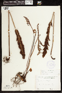 387504[1342736]Moore, John 170271945-06-06 United States, Minnesota, Todd, Todd Co. 1/2 mi E of Staples;;N;;, 46.355518 -94.781752 |
MIN:Plants | 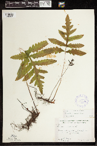 387505[1342828]Moore, John; Huff, N. 187311946-07-17 United States, Minnesota, Pine, Pine Co. Along Kettle River, 1 mi E of Hinckley;;N;;, 46.034791 -92.870994 |
MIN:Plants | 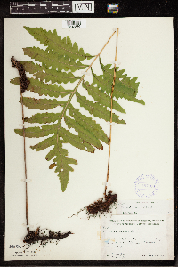 387506[1342836]Moore, John; et al. 191811946-08-31 United States, Minnesota, Morrison, Morrison Co. 1 mi S of "Snow" schoolhouse; Parker Twp.;;130N;31W;00, 46.007122 -94.278687 |
MIN:Plants | 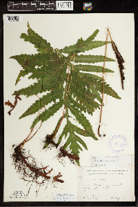 387507[1342780]Moore, John; Huff, N. 190041946-08-10 United States, Minnesota, Becker, Becker Co. 1/4 mi E of Two Island Lake [Twin Island Lake?];;142N;36W;, 47.136784 -95.271552 |
MIN:Plants | 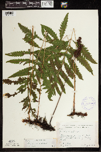 387508[1342826]Huff, N.; Moore, John 180971945-08-02 United States, Minnesota, Pine, Pine Co. Near St. Croix River, 1/2 mi S of Danbury Rd.;Saint Croix State Park;041N;16W;, 46.120767 -92.74127 |
MIN:Plants | 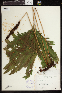 387509[1342781]Moore, John; Huff, N. 189071946-08-01 United States, Minnesota, Benton, Benton Co. 2 mi SW of Foley;;036N;29W;, 45.637967 -93.946555 |
MIN:Plants | 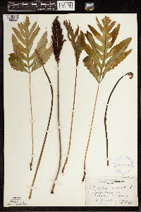 387510[1342820]Huff, N. s.n.1941-05-09 United States, Minnesota, Morrison, Parker Twp, Morrison Co.;;130N;31W;00, 46.007122 -94.278687 |
MIN:Plants | 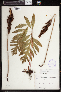 387511[1342682]Moore, John; Huff, N. 193901947-05-26 United States, Minnesota, Washington, Washington Co. William O'Brian State Park;William O'Brien State Park;032N;19W;, 45.217114 -92.763124 |
MIN:Plants |  391646[1342847]Butters, F.; Abbe, E.; Abbe, L. 3331937-07-10 United States, Minnesota, Cook, Cook Co.; along road by Hungry Jack Lake near trail to Leo Lake, T64N R1W;Superior National Forest;064N;01W;, 48.058252 -90.43604 |
MIN:Plants |  391647[1342848]Butters, F.; et al. 1501938-07-13 United States, Minnesota, Cook, Between Mountain and Pike Lakes.;Boundary Waters Canoe Area Wilderness / Superior National Forest;065N;02E;, 47.765692 -90.591554 |
MIN:Plants |  391648[1342845]Butters, F.; Abbe, E.; Abbe, L. 3691937-07-11 United States, Minnesota, Cook, Cook Co. On S side of Lucille Island, T63N R7E;North Shore / Susie Islands, The Nature Conservancy;063N;07E;, 47.726653 -90.386005 |
MIN:Plants |  401174[1342838]Benson, Robert 901941-08-01 United States, Minnesota, Anoka, Anoka Co. Carlos Avery Refuge. T33 R22S35;Carlos Avery Wildlife Management Area;033N;22W;35, 45.304244 -93.049488 |
MIN:Plants | 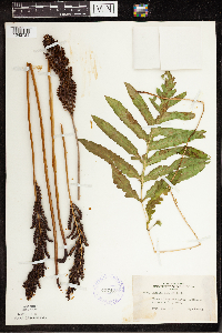 407429[1342724]Lakela, Olga 99271949-09-25 United States, Minnesota, Saint Louis, Prairie River, SW St. Louis Co.;;N;;, 46.7833 -92.9 |
MIN:Plants | 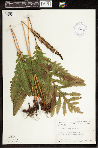 411985[1342713]Moore, John; Moore, Marjorie 111951939-07-27 United States, Minnesota, Lake of the Woods, Lake of the Woods Co. W side of Harrison River, Northwest Angle;Northwest Angle;N;;, 49.059039 -94.920086 |
MIN:Plants | 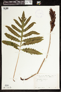 418955[1342711]Ahlgren, Clifford 1141949-06-22 United States, Minnesota, Lake, Quetico-Superior Wilderness Research Center...Lake Co. Sec.9 T64N R10W;Boundary Waters Canoe Area Wilderness / Superior National Forest;064N;10W;09, 47.583104 -91.421915 |
MIN:Plants | 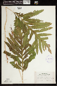 419425[1342790]Lakela, Olga 119541950-09-01 United States, Minnesota, Saint Louis, On Hwy.73, on Floodwood R. terrace, St. Louis Co. (about 6 mi N of Floodwood0;;N;;, 47.015968 -92.919648 |
MIN:Plants | 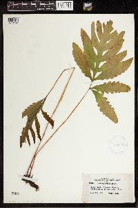 419914[1342792]Lakela, Olga 104281950-06-17 United States, Minnesota, Saint Louis, Sucker River at Pioneer Rd, St. Louis Co.;;N;;, 47.0667 -91.8667 |
MIN:Plants | 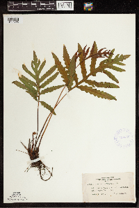 420759[1342788]Lakela, Olga 106211950-07-01 United States, Minnesota, Saint Louis, Twin Lakes; SE of Brookston, St. Louis Co.;;N;;, 47.521756 -92.462022 |
MIN:Plants | 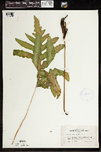 420884[1342789]Lakela, Olga 120781950-09-06 United States, Minnesota, Saint Louis, Side Lake at Sturgeon Lake, N of Hibbing, St. Louis Co.;;N;;, 47.4167 -92.9333 |
MIN:Plants | 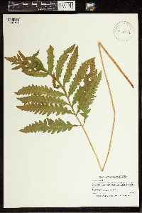 429547[1342794]Smith, Welby 194371991-07-10 United States, Minnesota, Koochiching, Koochiching State Forest. Koochiching County...On the north side of Moose Lake, about 6 miles east of Little Fork... T 68N R 24W SE1/4 of SE1/4 of Sec 9. 068N 24W 9, 48.3922234 -93.4236145 |
MIN:Plants | 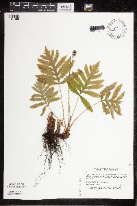 432158[1311353]Myhre, K. 37391993-05-31 United States, Minnesota, Pine, Pine Co. Located 1 mi SE of Cloverton; T42N R15W NW1/4 of NW1/4 of Sec 6;;042N;15W;6, 46.14943 -92.297131 |
MIN:Plants | 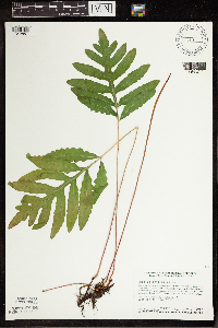 440153[1342857]Smith, Welby 128201987-06-02 United States, Minnesota, Scott, Murphy-Hanrahan County Park Reserve. Scott County...Murphy-Hanrahan Regional Park; on the S side of Hanrahan Lake, about 2 mi W of Burnsville SW1/4 NW1/4 sec 34, T115N R21W. 115N 21W 34, 44.7277778 -93.3363889 |
MIN:Plants | 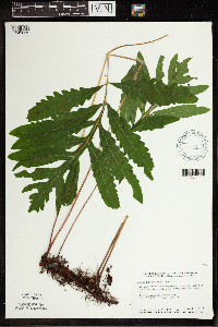 440221[1342856]Smith, Welby 128561987-06-04 United States, Minnesota, Mille Lacs, Mille Lacs Co. Mille Lacs State Wildlife Management Area, about 11 mi N of Bock. SE1/4 NE1/4 sec 24, T40N R26W;Mille Lacs Wildlife Management Area;040N;26W;24, 45.9472237 -93.5199966 |
MIN:Plants | 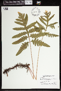 441711[1342648]Lee, Michael MDL1221993-05-14 United States, Minnesota, Dakota, Dakota Co.; Spring Lake County Park; T 115N R 18W NW1/4 of NE1/4 of Sec 21;Spring Lake County Park;115N;18W;21, 44.758413 -92.982219 |
MIN:Plants | 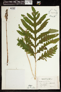 442296[1342813]Lakela, Olga 136851951-09-02 United States, Minnesota, Saint Louis, Pike Lake, 12 mi N of Duluth;;N;;, 46.956994 -92.106579 |
MIN:Plants | 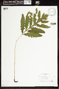 458772[1342744]Puchalski, L. 4331993-08-25 United States, Minnesota, Mahnomen, Mahnomen Co.; T143N R39W SW1/4 of NE1/4 of sEc 13;White Earth Indian Reservation / White Earth State Forest;143N;39W;13, 47.202327 -95.562059 |
MIN:Plants | 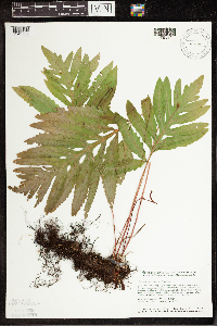 471830[1342704]Smith, Welby 129591987-06-16 United States, Minnesota, Washington, Washington County...on the E side of Highway 4, about 1/2 mi NW of Marine on St. Croix...about 150 feet above the floodplain of the St. Croix River; SW1/4 NE1/4 sec.1, T31N R20W. 031N 20W 1, 45.2061111 -92.7797222 |
MIN:Plants | 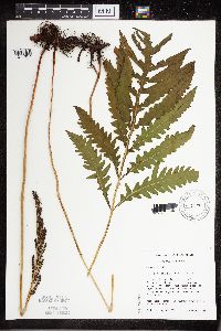 473679[1311357]Mensing, D. 95-5061995-08-07 United States, Minnesota, Carlton, Carlton Co. T48N R17W NW1/4 of the NW1/4 of S12; floodplain of Otter Creek; site located near railroad bed and County Ro Carlton Co. T48N R17W NW1/4 of the NW1/4 of S12; floodplain of Otter Creek; site located near railroad bed and County Route 210.. 048N 17W 12, 46.656716 -92.564903 |
MIN:Plants |  473680[1311354]Mensing, D. 95-9541995-08-23 United States, Minnesota, Carlton, Carlton Co, T49N R21W SE1/4 of the SW1/4 of S8; floodplain of the Little Tamarack River;;049N;21W;8, 46.740118 -93.033822 |
MIN:Plants |  473681[1342795]Mensing, D. 95-4621995-09-01 United States, Minnesota, Isanti, Isanti Co.; T34N R22W NW1/4 of the SW1/4 of S21; floodplain of West branch of Sunrise River;;034N;22W;21, 45.418876 -93.0981 |
MIN:Plants |  475361[1311359]Smith, Welby 211771992-07-31 United States, Minnesota, Le Sueur, Le Sueur Co.; At the south end of Fish Lake, about 2 miles north of Elysian; Le Sueur Co.; At the south end of Fish Lake, about 2 miles north of Elysian; T 109N R 24W SE1/4 of SE1/4 of Sec 23. 109N 24W 23, 44.2272224 -93.6699982 |
MIN:Plants |  475950[1311360]Smith, Welby 196081991-07-17 United States, Minnesota, Itasca, Itasca County...Scenic State Park, about 3 miles southeast of Big Fork...T 60N R 26W NE1/4 of NE1/4 of Sec 1;Scenic State Park;060N;26W;01, 47.7213889 -93.5805556 |
MIN:Plants |  519106[1342796]Puchalski, L. 2861993-07-16 United States, Minnesota, Polk, Polk Co.; T148N R43W SE1/4 of NW1/4 of Sec 25;;148N;43W;25, 47.607365 -96.078243 |
MIN:Plants |  525928[1342735]Lakela, Olga 186481955-06-04 United States, Minnesota, Saint Louis, St. Louis Co. Sturgeon River near the hwy bridge, #73;;N;;, 47.883814 -93.02962 |
MIN:Plants |  526276[1342737]Moore, John 210601951-06-26 United States, Minnesota, Todd, Todd Co. River 1/2 mi NE of Philbrook;;N;;, 46.288419 -94.709293 |
MIN:Plants |  53004[1342678]Holzinger, John s.n.1905-10-01 United States, Minnesota, Winona, La Moille Cave, in Winona Co.;;N;;, 44.049963 -91.639315 |
MIN:Plants | 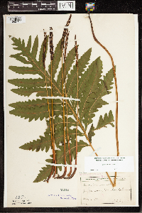 53007[1342708]Manning, Sara s.n.1892-08-20 United States, Minnesota, Wabasha, Lake City;;N;;, 44.449412 -92.266844 |
MIN:Plants | 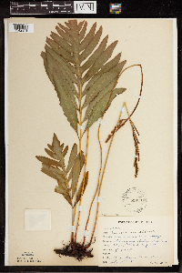 53009[1342841]Rosendahl, C. 22881909-07-15 United States, Minnesota, Snelling Reservation [old regional park spanning junction of Minnesota and Mississippi rivers];;028N;23W;, 44.90516 -93.16646 |
MIN:Plants | 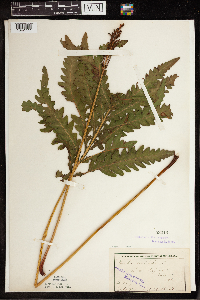 53013[1342777]Ballard, C. B16471893-07-00 United States, Minnesota, Cass, Lake Kilpatrick, Cass Co.;;135N;29W;, 46.495108 -94.365032 |
MIN:Plants | 53019[1342707]Lyon, H. 3261899-08-09 United States, Minnesota, Houston, Jefferson;Dorer Memorial Hardwood State Forest;101N;04W;35, 43.50806 -91.28287 |
MIN:Plants | 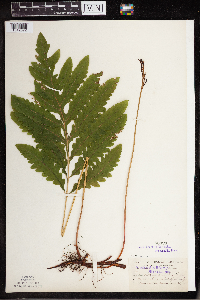 53020[1342672]Burglehaus, F. s.n.1891-06-30 United States, Minnesota, Hennepin, Hennein Co.;;N;;, 44.959601 -93.350342 |
MIN:Plants |  53024[1342706]Rosendahl, C. 5431902-06-17 United States, Minnesota, Houston, Spring Grove;;101N;07W;, 43.543165 -91.672028 |
MIN:Plants |  53027[1342671]Sandberg, John s.n.1890-07-00 United States, Minnesota, Hennepin, Hennepin Co.;;N;;, 45.004576 -93.476884 |
MIN:Plants |  533000[1342791]Lakela, Olga 198191956-06-16 United States, Minnesota, Saint Louis, St. Louis Co. Seven Beaver Lake, E side of the point;Superior National Forest;058N;12W;, 48.030785 -92.058533 |
MIN:Plants |  550058[1342677]Moore, John 220751954-09-15 United States, Minnesota, Sherburne, Sherburne Co. Along Rice Creek, SE1/4 Sec.9, Palmer Twp.;;035N;21W;9, 45.533358 -93.945857 |
MIN:Plants |  565246[1342849]Cotter, Shirley 2991948-07-27 United States, Minnesota, Clearwater, By gravel pit road Itasca Park, Clearwater Co.;Itasca State Park;143N;36W;, 47.197458 -95.201964 |
MIN:Plants |  566203[1342782]Moore, John; Bernardini, J. 242471958-09-17 United States, Minnesota, Blue Earth, Blue Earth Co. Along creek 3 mi W of Mankato;;N;;, 44.16233 -94.060637 |
MIN:Plants |  568884[1342778]Moore, John 252071960-08-12 United States, Minnesota, Anoka, Anoka Co. SW1/4 Sec.26, Cedar Creek Forest Area;Cedar Creek National History Area;034N;23W;26, 45.403507 -93.177721 |
MIN:Plants |  570362[1342837]Worcester, H. s.n.1961-09-28 United States, Minnesota, Aitkin, Aitkin Co. Growing along Sandy River about 3 mi NW of the town of McGregor;;048N;24W;, 46.640487 -93.34395 |
MIN:Plants | 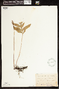 57110[1342714]Taylor, B. T201891-06-00 United States, Minnesota, Le Sueur, Elysian, Le Sueur Co.;;109N;24W;, 44.461354 -93.915242 |
MIN:Plants | 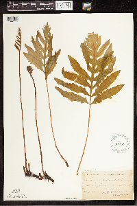 57112[1342715]Sheldon, Edmund S191891-06-00 United States, Minnesota, Le Sueur, Elysian;;109N;24W;, 44.461354 -93.915242 |
MIN:Plants | 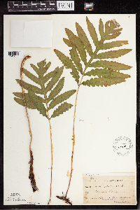 57115[1342633]Ballard, C. B541891-06-00 United States, Minnesota, Carver, Chaska;;N;;, 44.789407 -93.602179 |
MIN:Plants | 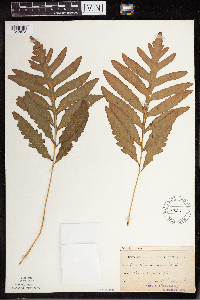 57128[1342673]Herrick, C. s.n.1878-07-00 United States, Minnesota, Hennepin, Minneapolis;;N;;, 44.979965 -93.263836 |
MIN:Plants |  57129[1342635]Ballard, C. B15n1891-06-00 United States, Minnesota, Carver, Chaska;;N;;, 44.789407 -93.602179 |
Google Map
Google Maps is a web mapping service provided by Google that features a map that users can pan (by dragging the mouse) and zoom (by using the mouse wheel). Collection points are displayed as colored markers that when clicked on, displays the full information for that collection. When multiple species are queried (separated by semi-colons), different colored markers denote each individual species.