University of Minnesota
http://www.umn.edu/
612-625-5000
http://www.umn.edu/
612-625-5000
Minnesota Biodiversity Atlas
Bell Museum
Dataset: MIN-Plants
Taxa: Pouteria
Search Criteria: excluding cultivated/captive occurrences
1
Page 1, records 1-13 of 13
Bell Museum plants | |
 MIN:Plants | 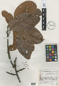 Pouteria ucuqui Pires & Schultes 450789[1002140]Schultes, R.E. 95531942-01-03 Brazil, Amazonas, Upper Rio Negro, Igrapé Uabá, opposite mouth of Rio Xié |
MIN:Plants | 896730[]Weiblen, G.D. TP0451996-07-31 Papua New Guinea, Simbu, O-Pio 1 ha plot, block 3, Crater Mountain Wildlife Management Area, -6.788611 145.036667, 550m |
MIN:Plants | 897334[]Weiblen, G.D. TP0871996-07-31 Papua New Guinea, Simbu, O-Pio 1 ha plot, block 4, Crater Mountain Wildlife Management Area, -6.788611 145.036667, 550m |
MIN:Plants | 896696[]Weiblen, G.D. TP1091996-07-31 Papua New Guinea, Simbu, O-Pio 1 ha plot, block 5, Crater Mountain Wildlife Management Area, -6.788611 145.036667, 550m |
MIN:Plants | 897342[]Weiblen, G.D. TP1491996-07-31 Papua New Guinea, Simbu, O-Pio 1 ha plot, block 7, Crater Mountain Wildlife Management Area, -6.788611 145.036667, 550m |
MIN:Plants | 896671[]Weiblen, G.D. TP1851996-07-31 Papua New Guinea, Simbu, O-Pio 1 ha plot, block 9, Crater Mountain Wildlife Management Area, -6.788611 145.036667, 550m |
MIN:Plants | 897372[]Weiblen, G.D. TP1881996-07-31 Papua New Guinea, Simbu, O-Pio 1 ha plot, block 9, Crater Mountain Wildlife Management Area, -6.788611 145.036667, 550m |
MIN:Plants | 897956[]Weiblen, G.D. TP3771996-07-31 Papua New Guinea, Simbu, O-Pio 1 ha plot, block 16, Crater Mountain Wildlife Management Area, -6.788611 145.036667, 550m |
MIN:Plants | 490610[]Stancik, D. Stancik & Nathaniel 51962003-09-17 Papua New Guinea, Madang, Baitabag, -5.133333 145.766667, 150m |
MIN:Plants | 489397[]Stancik, D. Stancik & Nathaniel 51972003-09-17 Papua New Guinea, Madang, Baitabag, -5.133333 145.766667, 150m |
MIN:Plants | 897345[]Weiblen, G. D. TP1491996-07-31 Papua New Guinea, Simbu, Crater Mountain Wildlife Management Area, O=Pio 1 ha plot, block 7, 6.788611 -145.036667, 500m |
MIN:Plants | 897856[]Weiblen, G.D. TP3771996-07-31 Papua New Guinea, Simbu, Crater Mountain Wildlife Management Area, O-Pio 1 ha plot, block 16, 6.788611 -145.036667, 550m |
MIN:Plants |  951837[]Weiblen, G. D. GW19252003-06-24 Costa Rica, Volcan Cacao, Area de Conservacion Guanacaste, 10.75 -85.166667 |
1
Page 1, records 1-13 of 13
Google Map
Google Maps is a web mapping service provided by Google that features a map that users can pan (by dragging the mouse) and zoom (by using the mouse wheel). Collection points are displayed as colored markers that when clicked on, displays the full information for that collection. When multiple species are queried (separated by semi-colons), different colored markers denote each individual species.