University of Minnesota
http://www.umn.edu/
612-625-5000
http://www.umn.edu/
612-625-5000
Minnesota Biodiversity Atlas
Bell Museum
Dataset: MIN-Plants
Taxa: Symphonia
Search Criteria: excluding cultivated/captive occurrences
1
Page 1, records 1-4 of 4
Bell Museum plants | |
 MIN:Plants | 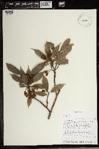 492134[1370097]Malcomber, S.T 19231992-12-07 Madagascar, East of Ankaramy, Reserve Speciale of Manongarivo. Bekolosy., -14.033333 48.316667, 800 - 1100m |
MIN:Plants | 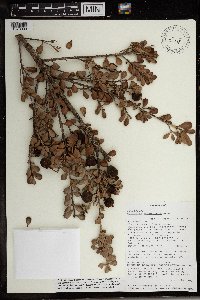 499377[1370098]R. Randrianaivo 6562001-07-02 Madagascar, Antananarivo, Fiv. Manjakandriana, commune Ankazondandy, Fkt. Antokonana, Route Nationale 3, PK 52-53, 500m au Nord d'Antokonana.; -18.669722 47.812778, -18.669722 47.812778, 1250m |
MIN:Plants | 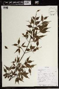 492706[1370099]Randriamanarivo, J. 282001-06-13 Madagascar, Vavatenina, Commune Miarinarivo, Fokontany Anamborano, Ambinanini, Sahavarina., -17.685556 48.995278 |
MIN:Plants | 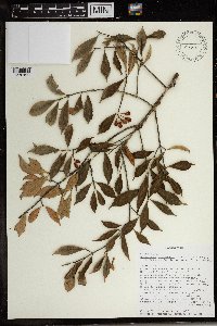 491308[1370100]Chris Birkinshaw 6021999-12-15 Madagascar, Community forest outside Zahamena National Park. 3km east of Andranomalaza Atsimo.; -17.653333 48.644167, -17.653333 48.644167, 1200m |
1
Page 1, records 1-4 of 4
Google Map
Google Maps is a web mapping service provided by Google that features a map that users can pan (by dragging the mouse) and zoom (by using the mouse wheel). Collection points are displayed as colored markers that when clicked on, displays the full information for that collection. When multiple species are queried (separated by semi-colons), different colored markers denote each individual species.