University of Minnesota
http://www.umn.edu/
612-625-5000
http://www.umn.edu/
612-625-5000
Minnesota Biodiversity Atlas
Bell Museum
Dataset: MIN-Plants
Taxa: Syringa
Search Criteria: excluding cultivated/captive occurrences
1
Page 1, records 1-30 of 30
Bell Museum plants | |
 MIN:Plants |  Syringa reticulata subsp. reticulata (Blume) H. Hara 914290[1034071]Schimpf, D. DJS5752009-09-06 United States, Minnesota, Saint Louis, St. Louis County, Duluth. T50N R14W SE1/4 Sec 13...NE side of London Rd.;;050N;14W;13, 46.8160413 -92.059779 |
MIN:Plants |  734321[1034084]MN Dept. of Natural Resources personnel s.n.1980-00-00 United States, Minnesota, Becker, Becker County...Green Water Lake Natural Area: 5 miles west of Ponsford. NW1/4 SW1/4 Sec. 33 T141N R38W;Greenwater Lake Scientific Natural Area / White Earth Indian Reservation;141N;38W;33, 46.98389 -95.4977 |
MIN:Plants |  Syringa reticulata subsp. reticulata (Blume) H. Hara 906917[1034073]Schimpf, D.; Bollin, LeAnn DJS4992008-09-17 United States, Minnesota, Saint Louis, St. Louis County, Duluth. T50N R14W NE1/4 Sec 11...W of Tischer Creek;;050N;14W;11, 46.8344444 -92.0758333 |
MIN:Plants |  426750[1034079]Juhnke, C. 172 CMJ FRO1999-05-05 United States, Minnesota, Goodhue, Frontenac State Park Goodhue County ... Along Cty.Rd.2. at entrance to trail to Sand Point ... T112N R13W SE SE NW 13;Frontenac State Park;112N;13W;13, 44.50536 -92.31909 |
MIN:Plants |  721222[1034085]Lustig, K. 8431979-08-08 United States, Minnesota, Sherburne, Clear Lake Scientific Natural Area. Sherburne County...Clear Lake-Mississippi Scenic and Recreational River, SNA: 12 miles southeast of St. Cloud, Sec. 14, 22, 23, T 34N, R 30W. 034N 30W 14, 45.44634 -94.04378 |
MIN:Plants |  171829[1034088]Taylor, B. T1581891-06-00 United States, Minnesota, Waseca, Janesville;;;;, 44.11611 -93.70778 |
MIN:Plants | 548898[]Pease, T. s.n.1888-06-30 United States, Minnesota, Anoka, [no further data];;N;;, 45.27455 -93.248718 |
MIN:Plants |  558545[1034089]Moore, John; Moore, Marjorie 235561957-09-19 United States, Minnesota, Isanti, Old house site, Cedar Creek Forest; NW1/4 Sec. 16 Athens Twp.;Cedar Creek National History Area;034N;23W;16, 45.43572 -93.21482 |
MIN:Plants |  574805[1034086]Moore, John 244451959-05-05 United States, Minnesota, Blue Earth, At old house site 3 mi N of Mankato;;;;, 44.20706 -93.99917 |
MIN:Plants |  574957[1034083]Wertman, Freida 611960-07-04 United States, Minnesota, Anoka, Cedar Creek National History Area. Cedar Creek Natural History Area, abandoned farm site, co. rd 24, N side, coordinates Map area surveyed 1960, 878.8-2208 Cedar Creek Natural History Area, abandoned farm site, co. rd 24, N side, coordinates Map area surveyed 1960, 878.8-2208.3; Athens Twp. Sec. 27. 034N 23W 27, 45.40678 -93.19373 |
MIN:Plants |  585421[1034081]Moore, John 260511962-06-26 United States, Minnesota, Kittson, Near the old James J. Hill helpers buildings 1/4 mi W of Northcote;;;;, 48.84525 -97.08879 |
MIN:Plants |  585623[1034087]Moore, John 262421963-05-16 United States, Minnesota, Anoka, At old house site, Cedar Creek Natural History Area; NE1/4 Sec. 27 Bethel Twp.;Cedar Creek National History Area;034N;23W;27, 45.40678 -93.19373 |
MIN:Plants |  697870[1034082]Ownbey, Gerald 52651976-08-12 United States, Minnesota, Clearwater, Itasca State Park. Becker Co. Itasca State Park, N side of Minn. rte no. 113, 1.7 mi W of its jnc with U.S. rte no. 71, abandoned farmstead Becker Co. Itasca State Park, N side of Minn. rte no. 113, 1.7 mi W of its jnc with U.S. rte no. 71, abandoned farmstead near hwy; T143N R36W SW1/4 Sec. 1. 143N 36W 1, 47.23229 -95.18024 |
MIN:Plants |  740027[1034080]Converse, C. 8531982-05-24 United States, Minnesota, Pope, Ordway Prairie; NW1/4 SW1/4 Sec. 19 T123N R36W NW1/4 SW1/4 Sec. 19;Ordway Prairie, The Nature Conservancy;123N;36W;19, 45.44867 -95.24502 |
MIN:Plants | 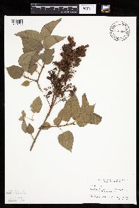 825690[1034090]Marion, J. s.n.1982-00-00 United States, Minnesota, Cook, Cook Co, North Shore of Lake Superior, ca. 200 ft. from lakeshore.;North Shore;;;, 47.46396 -91.02551 |
MIN:Plants | 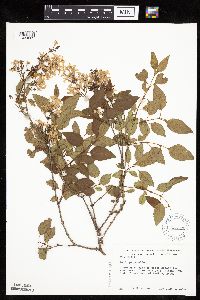 623122[1034069]Moore, John 273741971-06-04 United States, Minnesota, Isanti, Across the road W of Beckman Lake, Cedar Creek Natural History Area; Athens Twp.;Cedar Creek National History Area;034N;23W;, 45.42444 -93.18444 |
MIN:Plants | 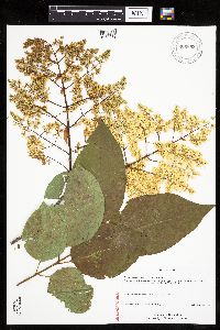 Syringa reticulata subsp. reticulata (Blume) H. Hara 906892[1034072]Schimpf, D.; Bollin, LeAnn DJS4862008-07-10 United States, Minnesota, Saint Louis, St. Louis County, Duluth. T50N R14W NE1/4 Sec 11...W of Tischer Creek;;050N;14W;11, 46.8344444 -92.0758333 |
MIN:Plants | 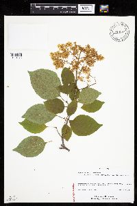 Syringa reticulata subsp. reticulata (Blume) H. Hara 914287[1034076]Schimpf, D. DJS5572009-07-18 United States, Minnesota, Saint Louis, St. Louis County, Duluth. T50N R14W SE1/4 Sec 13...NE side of London Rd.;;050N;14W;13, 46.8166667 -92.0513889 |
MIN:Plants | 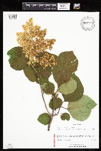 Syringa reticulata subsp. reticulata (Blume) H. Hara 914286[1034075]Schimpf, D. DJS5452009-07-11 United States, Minnesota, Saint Louis, St. Louis County, Duluth. T49N R15W Sec 27...S side of Clyde Ave. between 93rd & 94th Aves. W.;;049N;15W;27, 46.7008333 -92.2175 |
MIN:Plants | 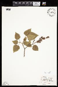 479290[1034091]Moore, John 3281971-07-14 United States, Minnesota, Sherburne, N.E. 1/4 S-10 Blue Hill [twp.];Sherburne National Wildlife Refuge;035N;27W;10, 45.53749 -93.68574 |
MIN:Plants | 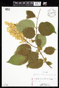 Syringa reticulata subsp. reticulata (Blume) H. Hara 914281[1034074]Schimpf, D. DJS5512009-07-13 United States, Minnesota, Saint Louis, St. Louis County, Duluth. T50N R14W Sec 13...Congdon Park Drive just below 4th St.;;050N;14W;13, 46.8191667 -92.0630556 |
MIN:Plants | 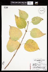 Syringa reticulata subsp. amurensis (F. Ruprecht) P.S. Greene & M.C. Chang 909125[1034070]Lee, C.; et al. 82008-10-12 United States, Minnesota, Ramsey, Ramsey Co, Como Park, 150 m east of Hamline Ave, south side of Midway Ave, just west of the mini golf course.;;029N;23W;22, 44.9805556 -93.1547222 |
MIN:Plants |  Syringa reticulata subsp. reticulata (Blume) H. Hara 914282[1034077]Schimpf, D. DJS5762009-09-06 United States, Minnesota, Saint Louis, St. Louis County, Duluth. T50N R14W Sec 13...Congdon Park Drive just below 4th St.;;050N;14W;13, 46.8191667 -92.0630556 |
MIN:Plants |  Syringa villosa Vahl 481085[1034078]Lakela, Olga 161841953-07-09 United States, Minnesota, Saint Louis, St. Louis County ... Hunters Hill at Duluth;;;;, 46.78333 -92.10639 |
MIN:Plants |  Syringa reticulata subsp. reticulata (Blume) H. Hara 914291[1034092]Schimpf, D. DJS5732009-09-06 United States, Minnesota, Saint Louis, St. Louis County, Duluth. T49N R15W Sec 27...S side of Clyde Ave. between 93rd & 94th Aves. W.;;049N;15W;27, 46.7008333 -92.2175 |
MIN:Plants | 578792[]Ownbey, Gerald 3175a1962-06-21 United States, Minnesota, Clearwater, Cultivated at old Wegman farmstead. NE1/4 of section.;Itasca State Park;143N;36W;02, 47.2319733 -95.201528 |
MIN:Plants | 578830[]Ownbey, Gerald 3175b1962-06-21 United States, Minnesota, Clearwater, Cultivated at old Wegman farmstead. NE1/4 of section;Itasca State Park;143N;36W;02, 47.2319733 -95.201528 |
MIN:Plants | 352702[]Eneboe, H. 881937-07-02 United States, Minnesota, Hennepin, Minneapolis, east of Malcolm Avenue.;;;;, 44.97123 -93.211372 |
MIN:Plants |  Syringa japonica Decne. 171830[1002679]Wolfegg, S. [?] 1902-07-05 illegible |
MIN:Plants |  964143[1375112] United States, Nebraska |
1
Page 1, records 1-30 of 30
Google Map
Google Maps is a web mapping service provided by Google that features a map that users can pan (by dragging the mouse) and zoom (by using the mouse wheel). Collection points are displayed as colored markers that when clicked on, displays the full information for that collection. When multiple species are queried (separated by semi-colons), different colored markers denote each individual species.