University of Minnesota
http://www.umn.edu/
612-625-5000
http://www.umn.edu/
612-625-5000
Minnesota Biodiversity Atlas
Bell Museum
Dataset: MIN-Plants
Taxa: Triodanis
Search Criteria: excluding cultivated/captive occurrences
1
Page 1, records 1-42 of 42
Bell Museum plants | |
 MIN:Plants | Triodanis coloradoensis (Buckley) McVaugh 197725[]Kelsey, F. s.n.1892-06-00 United States, Montana, Fergus, Hilger's |
MIN:Plants | 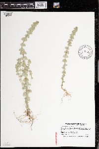 Triodanis perfoliata var. biflora (Ruiz & Pavon) T.R. Bradley 916043[1397375]Smith, Welby 223791993-06-08 United States, Minnesota, Dakota, Dakota County...On the south side of Highway 54, about 3 miles east of Hastings, in the Mississippi River Valley... T115N R16W NW1/4 of SW1/4 of Sec 31. 115N 16W 31, 44.7216667 -92.7919444 |
MIN:Plants | Triodanis perfoliata (L.) Nieuwland 281380[]Roberts, Thomas s.n.1886-06-06 United States, Pennsylvania, Ridley Park [Pennsylvania?];;;;, 39.881224 -75.323799 |
MIN:Plants | Triodanis perfoliata (L.) Nieuwland 690981[]Shane, L. 77-31977-06-30 United States, Ohio, Erie, Erie County ... bluff above west bank of Old Woman Creek estuary ca. 1-1/2 m. s of Lake Erie. In area of excavation of the Anderson site. |
MIN:Plants | Triodanis perfoliata var. biflora (Ruiz & Pavon) T.R. Bradley 197709[]Michener; Bioletti 14211892-06-12 United States, California, San Francisco, San Francisco County ... Lake Merced |
MIN:Plants | 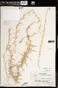 Triodanis leptocarpa (Nuttall) Nieuwland 412167[1397373]Moore, John; Moore, Marjorie 102011938-06-26 United States, Minnesota, Dakota, 1/4 mi W of Fifth Avenue and just S of Church Street, South St. Paul, Dakota Co.;;028N;22W;00, 44.9052257 -93.0450747 |
MIN:Plants | 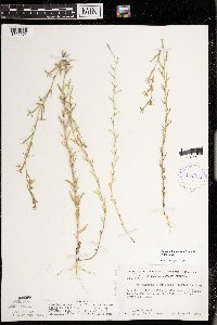 Triodanis leptocarpa (Nuttall) Nieuwland 412198[1397374]Moore, John; Moore, Marjorie 107601939-06-25 United States, Minnesota, Dakota, Dakota County...1/4 mi W of Fifth Avenue and just S of Church Street, South St. Paul;;028N;22W;00, 44.9052257 -93.0450747 |
MIN:Plants | Triodanis perfoliata (L.) Nieuwland 197788[]Lyon, H. 8951905-06-27 United States, Minnesota, Houston, Jefferson [pioneer village, no longer in existence], Houston Co.;Dorer Memorial Hardwood State Forest;101N;04W;35, 43.5080621 -91.2828714 |
MIN:Plants | Triodanis perfoliata (L.) Nieuwland 197789[]Ainslie, G. 34981902-06-23 United States, Minnesota, Olmsted, Rochester;;106N;14W;00, 43.97834 -92.498342 |
MIN:Plants | Triodanis perfoliata (L.) Nieuwland 197791[]Rosendahl, C. s.n.1902-06-00 United States, Minnesota, Houston, Spring Grove;;101N;07W;11, 43.56565 -91.64095 |
MIN:Plants | Triodanis perfoliata (L.) Nieuwland 197792[]MacMillan, C. M.491890-08-00 United States, Minnesota, Crow Wing, Brainard [sic];;133N;28W;03, 46.3687092 -94.2007138 |
MIN:Plants | Triodanis perfoliata (L.) Nieuwland 197793[]Lyon, H. 1481899-06-21 United States, Minnesota, Houston, Winnebago Valley;Dorer Memorial Hardwood State Forest;;;, 43.66667 -91.50056 |
MIN:Plants | Triodanis perfoliata (L.) Nieuwland 197794[]Kassube, J. s.n.1878-07-00 United States, Minnesota, Hennepin, Minneapolis;;029N;24W;25, 44.96996 -93.23702 |
MIN:Plants | Triodanis perfoliata (L.) Nieuwland 197795[]Rosendahl, C.; Butters, F. 38981920-06-24 United States, Minnesota, Houston, About 3 mi N of Jefferson village [pioneer village no longer in existence, sec. 35], SE Houston County;Dorer Memorial Hardwood State Forest;101N;04W;14, 43.5511307 -91.2827535 |
MIN:Plants | Triodanis perfoliata (L.) Nieuwland 357982[]Rosendahl, C. 2561902-06-02 United States, Minnesota, Houston, Spring Grove;;101N;07W;11, 43.56565 -91.64095 |
MIN:Plants | Triodanis perfoliata (L.) Nieuwland 366167[]Rosendahl, C. 71371939-06-11 United States, Minnesota, Houston, Riceford Creek valley, Houston Co.;Dorer Memorial Hardwood State Forest;;;, 43.60675 -91.70528 |
MIN:Plants | Triodanis perfoliata (L.) Nieuwland 370948[]Moore, John; et al. 133501940-06-27 United States, Minnesota, Redwood, About 7 mi S of Sacred Heart, Redwood County;;114N;37W;00, 44.67245 -95.299486 |
MIN:Plants | Triodanis perfoliata (L.) Nieuwland 446556[]Moore, John; Huff, N. 185051946-06-06 United States, Minnesota, Nicollet, Nicollet County...4 mi W of Courtland;;110N;30W;35, 44.290079 -94.401883 |
MIN:Plants | Triodanis perfoliata (L.) Nieuwland 568529[]Moore, John; et al. 250911960-06-24 United States, Minnesota, Blue Earth, Blue Earth County...2 mi west of Mankato;;;;, 44.166633 -94.013994 |
MIN:Plants | 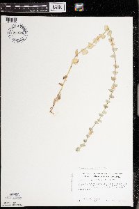 Triodanis perfoliata (L.) Nieuwland 701624[1397376]Ownbey, Gerald 62751979-07-14 United States, Minnesota, Houston, Houston County...T 101N R 5W Sect. 25 NE 1/4 of NW 1/4. Junction of Houston Co. Rte. 5 & Co. Rte. 31.;Dorer Memorial Hardwood State Forest;101N;05W;25, 43.5223903 -91.3820724 |
MIN:Plants | 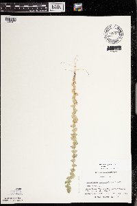 Triodanis perfoliata (L.) Nieuwland 738635[1397377]Galatowitsch, S. 2711982-06-15 United States, Minnesota, Wabasha, Wabasha County...Weaver Dunes: T109N R9W SE1/4 and E1/2 NE1/4 of Sec.7, NW1/4 and W1/2 NE1/4 of Sec 8;Kellogg-Weaver Dunes Scientific Natural Area / Kellogg-Weaver Dunes, The Nature Conservancy;109N;09W;00, 44.233108 -91.917245 |
MIN:Plants | 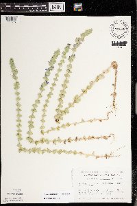 Triodanis perfoliata (L.) Nieuwland 743542[1397378]Nietering, E. 1401982-06-26 United States, Minnesota, Redwood, Redwood County...NE 1/4 NW 1/4 Sec. 10, R 36W, T113N. E of Delhi and just outside boundary of Cedar Ridge Wildlife Area;;113N;36W;10, 44.606918 -95.167652 |
MIN:Plants | 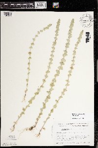 Triodanis perfoliata (L.) Nieuwland 743554[1397379]Nietering, E. 1051982-06-15 United States, Minnesota, Yellow Medicine, Blue Devil Valley Scientific Natural Area. Yellow Medicine County...Along western side of new Hwy 23, about 1/4 mi S from intersection of Hwys 39 and 67. SE 1/4 NE 1/4 Sec. 4, R 39 W, T115 N. City of Granite Falls. 115N 39W 4, 44.796844 -95.554369 |
MIN:Plants | Triodanis perfoliata (L.) Nieuwland 743724[]Nietering, E.; et al. 851982-05-29 United States, Minnesota, Redwood, Redwood County...NW 1/4 NW 1/4 Sec. 17, R 37W, T 114N. N of Belview;;114N;37W;17, 44.679459 -95.329738 |
MIN:Plants | 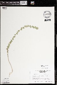 Triodanis perfoliata (L.) Nieuwland 747543[1397380]Homme, Virginia s.n.1983-07-01 United States, Minnesota, Chippewa, Chippewa County...About 2 mi SE of Granite Falls. SE 1/4 NW 1/4 Sec. 11, T 115N, R 39W;Gneiss Outcrops Scientific Natural Area;115N;39W;11, 44.7792874 -95.5130018 |
MIN:Plants | Triodanis perfoliata (L.) Nieuwland 758814[]Smith, Welby 64121982-06-19 United States, Minnesota, Wabasha, Wabasha County...About 2-1/2 mi E of Kellogg...NW1/4 SW1/4 sec.19, [T]110N R9W;Upper Mississippi National Wildlife Refuge;110N;09W;19, 44.316 -91.938756 |
MIN:Plants | 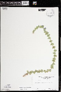 Triodanis perfoliata (L.) Nieuwland 759606[1397381]Homme, Virginia s.n.1984-06-27 United States, Minnesota, Renville, Renville County...Hawk Creek Township, SW 1/4 sec. 20;;115N;38W;20, 44.752493 -95.452609 |
MIN:Plants | Triodanis perfoliata (L.) Nieuwland 759616[]Homme, Virginia s.n.1984-06-27 United States, Minnesota, Chippewa, Chippewa County...Granite Falls Twp, sec.11;Gneiss Outcrops Scientific Natural Area;116N;39W;11, 44.8691898 -95.5137494 |
MIN:Plants | 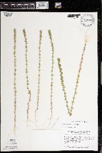 Triodanis perfoliata (L.) Nieuwland 770264[1397382]Smith, Welby 82731983-07-14 United States, Minnesota, Wabasha, Kellogg-Weaver Dunes Scientific Natural Area / Kellogg-Weaver Dunes, The Nature Conservancy. Wabasha County...Kellogg-Weaver Dunes State Scientific and Natural Area. About 4 mi SE of Kellogg, on the E side of County Road 84...NW1/4 NE1/4 section 6, T109N R9W. 109N 09W 6, 44.272608 -91.938983 |
MIN:Plants | 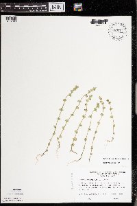 Triodanis perfoliata (L.) Nieuwland 780411[1397383]Ownbey, Gerald 70061985-06-05 United States, Minnesota, Washington, Washington County...T29N, R20W, Sec. 15, N end of E1/2 of the E1/2...ridge paralleling Minn. Rte. 95 just S of Bayport;Saint Croix Savanna Scientific Natural Area;029N;20W;15, 44.999636 -92.791781 |
MIN:Plants | Triodanis perfoliata (L.) Nieuwland 781292[]Smith, Welby 95201984-06-29 United States, Minnesota, Rock, Rock County...Blue Mounds State Park, about 2 mi N of Luverne...NW1/4 SW1/4 sec.25, T103N R45W;Blue Mounds State Park;103N;45W;25, 43.695974 -96.182724 |
MIN:Plants | 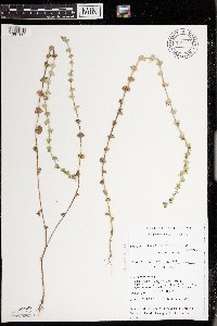 Triodanis perfoliata (L.) Nieuwland 782444[1397384]Tenney, M. 4671982-07-22 United States, Minnesota, Fillmore, Forestville State Park. Fillmore County...T. 102N R. 12W Sec. 13 NE1/4 SW1/4 NE1/4.;Forestville State Park;102N;12W;13, 43.6377242 -92.2192693 |
MIN:Plants |  Triodanis perfoliata (L.) Nieuwland 816254[1404008]Wheeler, Gerald 104351988-05-24 United States, Minnesota, Norman, Ca. 1 mi E of Twin Valley. Wild Rice River (N bank). N1/2 SW1/4 Sec.26 T144N R44W (Wild Rice Twp.).;;144N;44W;26, 47.259811 -96.226202 |
MIN:Plants | Triodanis perfoliata (L.) Nieuwland 197790[]Lyon, H. 8951905-06-27 United States, Minnesota, Houston, Jefferson [pioneer village near Iowa line], Houston Co.;Dorer Memorial Hardwood State Forest;101N;04W;35, 43.5080621 -91.2828714 |
MIN:Plants | Triodanis perfoliata var. biflora (Ruiz & Pavon) T.R. Bradley 197710[]Hasse, H. s.n.1890-05-00 United States, California, Los Angeles, Near Santa Monica |
MIN:Plants | Triodanis perfoliata (L.) Nieuwland 942619[]Dziuk, P. 14162014-06-18 United States, Minnesota, Houston, Behind residence about 2.74 miles south of Reno.;;;;, 43.5635417 -91.2828056 |
MIN:Plants |  Triodanis holzingeri McVaugh 337456[1002616]Hopkins, M. 6881936-06-12 United States, Oklahoma, McClain, Near Washington |
MIN:Plants |  Triodanis lamprosperma McVaugh 371718[1002617]Demaree, D. 211521940-05-06 United States, Arkansas, Pulaski, Little Rock, 152m |
MIN:Plants |  Triodanis perfoliata (L.) Nieuwland 961107[1334251]Timothy J. S. Whitfeld 16732018-06-06 United States, Rhode Island, Providence, Diamond Hill Reservation, Catamint Hill, 0.4 miles west south west of the intersection between Diamond Hill Road and Pine Swamp Road., 42.0036111 -71.4260278 |
MIN:Plants | Triodanis perfoliata (L.) Nieuwland 931639[]Lee, Michael MDL47172008-07-22 United States, Minnesota, Benton, Along the east bank of the Mississippi River at Peace Rock, 3.5 miles north of Sartell. N1/2 of SE1/4 of NW1/4 of section;;037N;31W;27, 45.6720103 -94.188084 |
MIN:Plants | Triodanis perfoliata (L.) Nieuwland 931643[]Lee, Michael MDL47362008-07-28 United States, Minnesota, Stearns, Quarry Park County Park on the south side of the city of Waite Park. SE1/4 of SE1/4 of SW1/4 of section;;124N;28W;20, 45.530745 -94.2309025 |
MIN:Plants |  Triodanis biflora (Ruiz & Pav.) Greene 0967746[1368309]Martin Jensen s.n.1938-00-00 United States, Texas |
1
Page 1, records 1-42 of 42
Google Map
Google Maps is a web mapping service provided by Google that features a map that users can pan (by dragging the mouse) and zoom (by using the mouse wheel). Collection points are displayed as colored markers that when clicked on, displays the full information for that collection. When multiple species are queried (separated by semi-colons), different colored markers denote each individual species.