University of Minnesota
http://www.umn.edu/
612-625-5000
http://www.umn.edu/
612-625-5000
Minnesota Biodiversity Atlas
Bell Museum
Dataset: MIN-Plants
Taxa: Verbascum
Search Criteria: excluding cultivated/captive occurrences
Bell Museum plants | |
 MIN:Plants | 916893[]Smith, Welby 251731994-08-18 United States, Minnesota, Beltrami, Lake Bemidji State Park. Beltrami County ... On the northeast side of Lake Bemidji, in Lake Bemidji State Park ... T147N R33W SW1/4 of NE1/4 of Sec 23. 147N 33W 23, 47.5347222 -94.8311111 |
MIN:Plants | 499266[]Juhnke, C. 402 CMJ FRO1999-07-01 United States, Minnesota, Goodhue, Frontenac State Park Goodhue County ...On Rattelsnake [sic] Bluff near bridge on Hill Ave. ... T112N R13W SW SW NE 5;Frontenac State Park;112N;13W;05, 44.534983 -92.400158 |
MIN:Plants | 520909[]Gerdes, Lynden 30151998-07-22 United States, Minnesota, Cook, Superior National Forest. T65N R03W S32SWNE. Cook County ... Superior National Forest. Boat landing/public access area at the far west end of Loon Lake.. 065N 03W 32, 48.070286 -90.740698 |
MIN:Plants | 912486[]Smith, Welby 230421993-07-21 United States, Minnesota, Meeker, Meeker County... On the south side of T.H. 12; about 2 miles southeast of Darwin... T119N R30W NW1/4 of SE1/4 of Sec 25;;119N;30W;25, 45.0872222 -94.3916667 |
MIN:Plants | 430235[]DeMink, L. 3982000-09-18 United States, Minnesota, Morrison, Crane Meadows National Wildlife Refuge; NWNE 30-T40N-R31W;Crane Meadows National Wildlife Refuge;040N;31W;30, 45.933896 -94.251565 |
MIN:Plants | 913053[]Smith, Welby 229871993-07-20 United States, Minnesota, Sibley, Sibley County ... At the southeast corner of Silver Lake, about 5 miles east of Arlington ... At the public access... T113N R26W NW1/4 of NW1/4 of Sec 9. 113N 26W 9, 44.6130556 -93.9686111 |
MIN:Plants | 506948[]Bright, R. 72-41972-00-00 United States, Idaho, Franklin, [no further data] |
MIN:Plants | 794681[]Schaaf, J. 3031982-10-03 United States, California, Alpine, Alpine Co. ... Toiyabe Nat'l Forest, Grover Hot Springs, 2438m |
MIN:Plants | 906093[]Nelson, Michael; et al. M202008-10-15 United States, Minnesota, Ramsey, Ramsey Co, Hidden Falls Park, approx 0.5 Km south of Ford parkway along East Rivr Road, by a park trail along the bluff;Hidden Falls - Crosby Farm Regional Park;028N;23W;17, 44.912243 -93.197369 |
MIN:Plants | 454219[]Mortensen, Carol Estes LL16481999-07-11 United States, Minnesota, Beltrami, Leech Lake Reservation and Chippewa National Forest; FS 2390; T148N, T31W, NWNW36;Chippewa National Forest;148N;31W;36, 47.389598 -94.589462 |
MIN:Plants | 282511[]Lakela, Olga 5751933-06-25 United States, Minnesota, Hennepin, below the University [Univ. of Minn.] Hospital, Minneapolis.;;N;;, 44.965969 -93.23843 |
MIN:Plants | 263572[]Holzinger, John s.n.1901-06-00 United States, Minnesota, Winona, Winona Co.;;N;;, 43.98685 -91.779129 |
MIN:Plants | 265424[]Goldsmith, G. G.581912-00-00 United States, Minnesota, Dakota, Northfield;;N;;, 44.458298 -93.161604 |
MIN:Plants | 271411[]Aiton, G. s.n.1889-08-00 United States, Minnesota, Hennepin, [no further data];;;;, 45 -93.47 |
MIN:Plants | 271414[]Manning, Sara s.n.1884-07-23 United States, Minnesota, Wabasha, Lake City;;N;;, 44.449412 -92.266844 |
MIN:Plants | 271415[]Campbell, Jennie C.1761896-07-00 United States, Minnesota, Stearns, Rockville;;123N;29W;, 45.471909 -94.340827 |
MIN:Plants | 271416[]Sandberg, John s.n.1881-07-00 United States, Minnesota, Goodhue, Cannon Falls;;N;;, 44.506911 -92.905484 |
MIN:Plants | 271417[]Sheldon, Edmund S221891-06-00 United States, Minnesota, Le Sueur, Elysian;;109N;24W;, 44.198577 -93.673838 |
MIN:Plants | 271418[]Kassube, J. s.n.1877-00-00 United States, Minnesota, Hennepin, Minneapolis;;N;;, 44.979965 -93.263836 |
MIN:Plants | 271419[]Taylor, B. T2971891-06-00 United States, Minnesota, Waseca, Janesville;;N;;, 44.116078 -93.708004 |
MIN:Plants | 271420[]Frost, W. F2991892-07-00 United States, Minnesota, Kandiyohi, Willmar;;N;;, 45.121908 -95.043342 |
MIN:Plants | 271421[]Ballard, C. B25n1891-06-00 United States, Minnesota, Carver, Chaska;;N;;, 44.789407 -93.602179 |
MIN:Plants | 271422[]Ballard, C. B5591891-07-00 United States, Minnesota, Scott, Prior Lake;;N;;, 44.720982 -93.425645 |
MIN:Plants | 271425[]Sandberg, John s.n.1890-07-00 United States, Minnesota, Hennepin, [no further data];;;;, 45 -93.47 |
MIN:Plants | 271426[]Herrick, C. s.n.1876-07-00 United States, Minnesota, Hennepin, Minneapolis;;N;;, 44.979965 -93.263836 |
MIN:Plants | 346735[]Lakela, Olga 21121937-08-01 United States, Minnesota, Saint Louis, at the jnc of Snively Boulevard and Jean Du Luth Rd, Duluth.;;N;;, 46.7833 -92.1 |
MIN:Plants | 353682[]Moyle, J. 13101934-07-12 United States, Minnesota, Hubbard, Itasca Park. Near entrance of park.;Itasca State Park;143N;35W;, 47.19592 -95.107697 |
MIN:Plants | 372995[]Moore, John; et al. 145981941-07-05 United States, Minnesota, Wright, edge of Pleasant Lake; Annandale. Wright Co.;;;;, 45.27492 -94.124696 |
MIN:Plants | 393025[]Lakela, Olga 73171947-09-02 United States, Minnesota, Saint Louis, Roadside near Brookston on Hwy. 2.;;N;;, 46.86772 -92.603804 |
MIN:Plants | 393531[]Stevens, O. s.n.1947-08-18 United States, Minnesota, Clay, [no further data];Buffalo River State Park;139N;46W;10, 46.863699 -96.472855 |
MIN:Plants | 416677[]Lakela, Olga 85001949-06-25 United States, Minnesota, Saint Louis, roadside, #21, Ely.;;N;;, 47.9 -91.8667 |
MIN:Plants | 420616[]Lakela, Olga 109561950-07-29 United States, Minnesota, Saint Louis, at Duluth Air Port, Duluth.;;N;;, 46.7833 -92.1 |
MIN:Plants | 421222[]Lakela, Olga 111291950-08-04 United States, Minnesota, Saint Louis, Trail along the Whiteface River dam, 6 mi. S of Markham.;;N;;, 47.196447 -92.2167 |
MIN:Plants | 429836[]Smith, Welby 196011991-07-17 United States, Minnesota, Itasca, Itasca Co.; Scenic State Park; about 3 miles southeast of Big Fork; T 60N R 26W NE1/4 of NE1/4 of Sec 1;Scenic State Park;060N;26W;1, 47.7213898 -93.5805588 |
MIN:Plants | 439854[]Myhre, K. 42211993-07-21 United States, Minnesota, Pine, Pine Co. Located 4 mi N of Head of the Rapids Landing on the St. Croix River; T40N R19W SE1/4 of SW1/4 of Sec 10;Saint Croix State Park;040N;19W;10, 45.967864 -92.701796 |
MIN:Plants | 443067[]Lakela, Olga 135491951-08-08 United States, Minnesota, Saint Louis, Old North Shore Rd. Lester Park, Duluth.;North Shore;050N;13W;05, 46.7833 -92.1 |
MIN:Plants | 445913[]Moore, John; Huff, N. 180091945-07-26 United States, Minnesota, Morrison, Along the shore of Twin Lakes, 5 mi. W of Little Falls;;N;;, 45.976307 -94.466673 |
MIN:Plants | 457313[]Myhre, K. 52101994-07-25 United States, Minnesota, Itasca, Itasca Co.; located 1/2 mile W of the town of Spring Lake; T 148N R 25W NW1/4 of NW1/4 of Sec 17;Chippewa National Forest / Leech Lake Indian Reservation;148N;25W;17, 47.640407 -93.875262 |
MIN:Plants | 458600[]Puchalski, L. 3971993-08-11 United States, Minnesota, Polk, Polk Co.; T148N R43W SW1/4 of SW1/4 of Sec 24;;148N;43W;24, 47.62176 -96.078286 |
MIN:Plants | 460316[]Smith, Welby 210451992-07-20 United States, Minnesota, Redwood, Cedar Rock Wildlife Management Area. Redwood Co.; In Cedar Rock State Wildlife Management Area, about 4 miles north-northwest of Redwood Falls; Redwood Co.; In Cedar Rock State Wildlife Management Area, about 4 miles north-northwest of Redwood Falls; T 113N R 36W NW1/4 of NW1/4 of Sec 11. 113N 36W 11, 44.6122208 -95.1563873 |
MIN:Plants | 460594[]Myhre, K. 3721991-07-10 United States, Minnesota, Aitkin, Aitkin County...Located 1.8 miles southeast of Elm Island Lake...T 46N R 26W SE1/4 of NE1/4 of Sec 26;;046N;26W;26, 46.440545 -93.582525 |
MIN:Plants | 464484[]Nation, R. 94-2351994-07-05 United States, Minnesota, Mower, Lake Louise State Park. Mower Co.; Tract 6. T101N R14W SW1/4 of NE1/4 of Sec. 29;Lake Louise State Park;101N;14W;29, 43.522073 -92.538882 |
MIN:Plants | 501620[]Stevens, O. s.n.1954-09-15 United States, Minnesota, Pipestone, Pipestone Nat. Monument;Pipestone National Monument;106N;46W;, 44.013519 -96.324755 |
MIN:Plants | 514904[]Smith, Welby 192851991-07-09 United States, Minnesota, Koochiching, Pine Island State Forest. Koochiching County ... about 5 miles southwest of Big Falls. Along Hickes Ridge Road, about 0.5 mile north of U.S. Hwy 71. Abandoned gravel pit ... T 154N R 25W NE1/4 of SW1/4 Sec. 30. 154N 25W 30, 48.127224 -93.8974991 |
MIN:Plants | 518737[]Darveaux, B. s.n.1991-06-24 United States, Minnesota, Washington, Forest Lake, Anoka Co. [Washington Co.] Left side of exit ramp 129 off of highway 35.;;032N;21W;7, 45.275646 -93.009582 |
MIN:Plants | 519922[]Smith, Welby 196721991-07-18 United States, Minnesota, Roseau, Roseau Co.; in Warroad, boat landing on Lake of the Woods (Muskeg Bay); T163N R36W SE1/4 of SW1/4 of SEc 28;;163N;36W;28, 48.9055557 -95.3016663 |
MIN:Plants | 526615[]Merrell, Ted s.n.1947-09-28 United States, Minnesota, Rice, Northfield;;N;;, 44.458298 -93.161604 |
MIN:Plants | 542494[]Moore, John 213811951-10-09 United States, Minnesota, Steele, Growing along the N shore of Rice Lake, Sec.11, Havana Twp.;Rice Lake State Park;107N;19W;, 44.089657 -93.068933 |
MIN:Plants | 542952[]Lakela, Olga; Davidson, Donald 216741957-07-26 United States, Minnesota, Lake, Cleared area on Tomahawk Trail close to Jct. No. 1;Superior National Forest;;;, 47.75 -91.5 |
MIN:Plants | 549862[]Moore, John 219601954-09-13 United States, Minnesota, Sherburne, 3 1/2 mi. S of Princeton;;N;;, 45.516159 -93.568582 |
MIN:Plants | 553707[]Moore, John 226881955-07-27 United States, Minnesota, Otter Tail, Along the S shore of Tamarac Lake, W of Dunvilla;;N;;, 46.664663 -96.077964 |
MIN:Plants | 558298[]Moore, John; Hsi, Yu-tseng [Eugene] 234231957-08-07 United States, Minnesota, Blue Earth, Along the Le Sueur River, Sec. 7, Decoria Twp.;;N;;, 44.086939 -93.998328 |
MIN:Plants | 558375[]Moore, John; Moore, Marjorie 235711957-09-19 United States, Minnesota, Isanti, N of the Cornea House, SW1/4 Sec. 22, Athens Twp, Cedar Creek Forest.;Cedar Creek National History Area;034N;23W;22, 45.417997 -93.197853 |
MIN:Plants | 560730[]Ownbey, Gerald 27891959-07-08 United States, Minnesota, Clearwater, SE1/4 Sec.27 T144N R36W. 0.2 mi W of Lake Itasca Post Office.;;144N;36W;27, 47.260545 -95.223135 |
MIN:Plants | 572586[]Moore, John 256591961-07-20 United States, Minnesota, Anoka, N of the laboratory, Cedar Creek Natural History Area.;Cedar Creek National History Area;034N;23W;, 45.40217 -93.199397 |
MIN:Plants | 572990[]Stevens, O. 26311902-08-22 United States, Minnesota, Clay, along entrance, Buffalo State Park;Buffalo River State Park;139N;46W;10, 46.857747 -96.623129 |
MIN:Plants | 574972[]Wertman, Freida 3511960-09-27 United States, Minnesota, Anoka, SW Sec. Co. rd. 24, N side; Coordinates 877.5-2205.7.;Cedar Creek Ecosystem Preserve;034N;23W;27, 45.407304 -93.193728 |
MIN:Plants | 585284[]Moore, John 258791962-05-08 United States, Minnesota, Houston, 1/2 mi S of Money Creek.;Dorer Memorial Hardwood State Forest;104N;07W;, 43.777468 -91.599093 |
MIN:Plants | 585369[]Moore, John 261901962-10-02 United States, Minnesota, Houston, 1 mi N of La Crescent.;;104N;04W;, 43.842506 -91.304027 |
MIN:Plants | 592183[]Westkaemper, Remberta s.n.1961-09-00 United States, Minnesota, Stearns, Stearns Co. St. Joseph;;124N;29W;, 45.564772 -94.317966 |
MIN:Plants | 607311[]Grafstrom, M. 1501968-08-01 United States, Minnesota, Hubbard, 1/4 mi E of hwy 71 on N boundary road.;;N;;, 46.882396 -95.065582 |
MIN:Plants | 616387[]Moore, John; Moore, Marjorie 3451969-07-23 United States, Minnesota, Crow Wing, Crow Wing Natural History Area. Growing along the S line of the NW1/4 Sec.20 Garrison Twp.;Crow Wing Natural Area;044N;28W;20, 46.279576 -93.905028 |
MIN:Plants | 628187[]Ownbey, Gerald 45831972-07-12 United States, Minnesota, Scott, Scott Co. Shakopee Prairie, ca. 4 mi. S of Shakopee, W side of Rte. 169. SW1/4 SE1/4 Sec. 21, T115N, R23W.;;115N;23W;21, 44.751113 -93.58769 |
MIN:Plants | 635026[]Lindayen, T. 1611972-08-15 United States, Minnesota, Washington, T30N R21W SE1/4 of Sec.16, 2.7 mi E of hwy 96 from jnc of hwy 244 & 96.;;030N;21W;16, 45.082967 -92.929038 |
MIN:Plants | 681717[]Gustitus, J. 591973-10-06 United States, Minnesota, Dakota, Dakota Co. Hwy. 55, 15 mi N [NW] of Hastings.;;N;;, 44.671881 -93.065424 |
MIN:Plants | 685085[]Stassen, Carol 1491977-06-25 United States, Minnesota, Lyon, Camden State Park; T111N R42W Sec.32 SE1/4.;Camden State Park;111N;42W;32, 44.374278 -95.922782 |
MIN:Plants | 686075[]Anonymous s.n.1900-07-15 United States, Minnesota, Morrison, Royalton;;N;;, 45.829965 -94.293609 |
MIN:Plants | 687508[]Wheeler, Gerald; Glaser, Paul 19501977-07-09 United States, Minnesota, Itasca, Chippewa National Forest / Leech Lake Indian Reservation. Itasca Co.; Coll. Site #97. NE1/4 NW1/4 Sec.3 T145N R26W; approx. 21 mi W-NW of Grand Rapids. Floodplain terrace of the Itasca Co.; Coll. Site #97. NE1/4 NW1/4 Sec.3 T145N R26W; approx. 21 mi W-NW of Grand Rapids. Floodplain terrace of the Mississippi River just S of where hwy 2 crosses the river (E bank).. 145N 26W 3, 47.324893 -93.959436 |
MIN:Plants | 689574[]Marshall, John s.n.1967-09-17 United States, Minnesota, Chisago, Edge of Chisago Lake, Chisago Twp.;;N;;, 45.363683 -92.864515 |
MIN:Plants | 689671[]Marshall, John s.n.1967-09-17 United States, Minnesota, Chisago, Edge of Chisago Lake, Chisago Twp.;;N;;, 45.363683 -92.864515 |
MIN:Plants | 690527[]Siemers, Ross 1041977-07-29 United States, Minnesota, Morrison, MacDougall Homestead Preserve, ca. 15 mi. SE of Little Falls. T39N, R32W, Sec. 28 & 29.;MacDougall Homestead, The Nature Conservancy;039N;32W;, 45.822572 -94.141523 |
MIN:Plants | 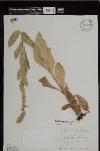 696561[1296986]Smith, Welby 7091978-07-23 United States, Minnesota, Wright, T 121 R 27W SW1/4 of section 9; T121N R27W S9, 45.304306 -94.086623 |
MIN:Plants | 698878[]Sather, Nancy; et al. 5121977-08-18 United States, Minnesota, Saint Louis, St. Louis Co. along hwy 1, SE1/4 SE1/4 S34 T63N R12W;Superior National Forest;T063N R12W S34, 47.896818 -91.851704 |
MIN:Plants | 699563[]Ziegler, S.; et al. 18551975-07-18 United States, Minnesota, Houston, Island 22; Mississippi River - mile #700; T104N R4W Sec.2...Large island E side of main channel; N end of island;Upper Mississippi National Wildlife Refuge;104N;04W;02, 43.839148 -91.286754, 194m |
MIN:Plants | 700935[]Dorio, J. 5751977-07-19 United States, Minnesota, Morrison, Lake Alexander, ca. 7 mi. N of Randall on Co. Rd. 6.;;131N;30W;6, 46.187068 -94.506234 |
MIN:Plants | 701016[]Dorio, J. 7191977-08-03 United States, Minnesota, Morrison, Ripley Esker, about 3 mi NE of Camp Ripley jnc. T42N R31W Sec.19.;Ripley Esker Scientific Natural Area;042N;31W;19, 46.116667 -94.308333 |
MIN:Plants | 701490[]Dorio, J. 8481977-09-01 United States, Minnesota, Morrison, Co.: Morrison ... Sandhill Crane Meadow, 4.5 mi. W of Buckman on Hwy. 34. T39N, R31W, Sec. 3 & 4.;Crane Meadows National Wildlife Refuge;039N;31W;, 45.904403 -94.188579 |
MIN:Plants | 716998[]Heitlinger, M. 7471975-07-08 United States, Minnesota, Anoka, Anoka Co. Allison Savanna. N1/2 of NE1/4 of Sec.2 T33N R23W. W side of old field.;Helen Allison Savanna Scientific Natural Area;033N;23W;2, 45.380475 -93.168729 |
MIN:Plants | 721178[]Lustig, K. 9541979-08-21 United States, Minnesota, Sherburne, Clear Lake-Mississippi Scenic and Recreational River, SNA: 12 mi. SE of St. Cloud, Sec. 14, 22, 23, T34N, R30W.;Clear Lake Scientific Natural Area;034N;30W;, 45.429169 -94.042303 |
MIN:Plants | 722598[]Lustig, K. 7471979-07-18 United States, Minnesota, Anoka, 18 mi. SE of Cambridge.;Boot Lake Scientific Natural Area;033N;22W;, 45.34066 -93.08146 |
MIN:Plants | 728104[]Lustig, K. 7201979-07-12 United States, Minnesota, Sherburne, Mississippi River Islands Scientific Natural Area. Sherburne & Wright Cos. ...Mississippi Scenic and Recreational River Islands SNA: Mississippi River Islands between Monticello and Elk River, Sec. 2, 3, 4, T32N R26, 27W; Sec. 7, 9, 18, T121N R23, 24W.. 032N 26W 3, 45.301026 -93.662501 |
MIN:Plants | 729165[]Berlin, N. 1161979-07-23 United States, Minnesota, Goodhue, Wacouta Pond Natural Area: 5 mi SE of Red Wing. Portions of : Sec.6 T112N R13W and Sec. 31, 32 T113N R13W.;Wacouta Pond Natural Area, The Nature Conservancy;;;, 44.539796 -92.413089 |
MIN:Plants | 730430[]Converse, C. 5841980-08-11 United States, Minnesota, Chisago, Goose Creek Natural Area: 5 mi SE of Rush City. NW1/4 Sec.18 T36N R20W.;Wild River State Park;036N;20W;18, 45.611144 -92.892612 |
MIN:Plants | 734346[]Severson, M. 4871980-07-09 United States, Minnesota, Becker, Green Water Lake Natural Area: 5 mi W of Ponsford. SW1/4 NW1/4 Sec.33 T141N R38W.;Greenwater Lake Scientific Natural Area / White Earth Indian Reservation;141N;38W;33, 46.985358 -95.505511 |
MIN:Plants | 734829[]Petron, T. 2601980-07-14 United States, Minnesota, Clay, Bluestem Prairie: 13 mi E of Moorhead. NW1/4 NE1/4 Sec.15 T139N R46W.;Bluestem Prairie Scientific Natural Area;139N;46W;15, 46.855337 -96.473419 |
MIN:Plants | 739369[]Stackler, S. 17341976-07-02 United States, Minnesota, Carlton, Skunk Creek Basin. Co. 102. Ca. 10 mi E, 1/2 mi N Barnum. (T46N R17W S35).;;046N;17W;35, 46.425023 -92.456479 |
MIN:Plants | 739671[]Converse, C. 18601982-07-28 United States, Minnesota, Pope, SE1/4 SW1/4 SEc.34. Moe Woods. T123N R36W.;Moe Woods, The Nature Conservancy;123N;36W;34, 45.41981 -95.183337 |
MIN:Plants | 739777[]Converse, C. 17911982-07-25 United States, Minnesota, Chippewa, Chippewa Co. SW1/4 NW1/4 Sec.1. SW1/4 NW1/4 Sec.1. Chippewa Prairie: T119N R43W;Chippewa Prairie, The Nature Conservancy;119N;43W;1, 45.145925 -95.998129 |
MIN:Plants | 744555[]Converse, C. 22771982-09-03 United States, Minnesota, Pope, NE1/4 NE1/4 Sec.30. Ordway Prairie: T123N R36W.;Ordway Prairie, The Nature Conservancy;123N;36W;30, 45.434262 -95.245019 |
MIN:Plants | 747311[]Galatowitsch, S. 5651982-07-27 United States, Minnesota, Wabasha, Wabasha County...Weaver Dunes: T109N R9W SE1/4 and E1/2 NE1/4 of Sec.7; NW1/4 and W1/2 NE1/4 of Sec.8.;Kellogg-Weaver Dunes Scientific Natural Area / Kellogg-Weaver Dunes, The Nature Conservancy;109N;09W;00, 44.258107 -91.938909 |
MIN:Plants | 770598[]Smith, Welby 84281983-07-26 United States, Minnesota, Mower, Lake Louise State Park. NW1/4 NE1/4 Sec. 28, T101N, R14W.;Lake Louise State Park;101N;14W;28, 43.522099 -92.518958 |
MIN:Plants | 773948[]Boe, J. 6121979-07-08 United States, Minnesota, Lake of the Woods, Hwy. 2 N of Williams. Sec. 24, R34W, T163N.;;163N;34W;24, 48.923418 -94.97099 |
MIN:Plants | 782299[]Tenney, M. 4701982-07-22 United States, Minnesota, Fillmore, Forestville State Park. Fillmore Co. T102N, R12W, Sec. 13, SE1/4 SW1/4 NE1/4;Forestville State Park;102N;12W;13, 43.637724 -92.219269 |
MIN:Plants | 782477[]Tenney, M. 4811982-07-27 United States, Minnesota, Winona, Whitewater State Park. Winona Co. T107N, R10W, Sec. 20, NW1/4 SE1/4 SW1/4.;Whitewater State Park;107N;10W;20, 44.056501 -92.049518 |
MIN:Plants | 801044[]Smith, Welby 123971986-08-10 United States, Minnesota, Wabasha, Snake Creek Recreation Area, about 3 mi S of Kellogg. SE1/4 NE1/4 sec.10 T109N R10W;Dorer Memorial Hardwood State Forest;109N;10W;10, 44.2580566 -91.9916687 |
MIN:Plants | 802993[]Smith, Welby 121011986-07-08 United States, Minnesota, Dodge, Iron Horse Prairie Scientific Natural Area. Dodge County...Iron Horse Prairie State Scientific and Natural Area, about 1 1/2 mi S of Hayfield. NW1/4 SE1/4 sec.27 T105N R17W. 105N 17W 27, 43.8675 -92.8486111 |
MIN:Plants | 815970[]Wheeler, Gerald 115731988-07-28 United States, Minnesota, Big Stone, Ca. 2.5 mi. SSE of Ortonville; Big Stone National Wildlife Refuge, SW of Rte. 75. Near 'wildlife drive'. NE1/4 Sec. 27 Ca. 2.5 mi. SSE of Ortonville; Big Stone National Wildlife Refuge, SW of Rte. 75. Near 'wildlife drive'. NE1/4 Sec. 27, T121N, R46W (Ortonville Twp.).. 121N 46W 27, 45.510498 -96.765029 |
MIN:Plants | 816255[]Wheeler, Gerald 114031988-07-25 United States, Minnesota, Lac Qui Parle, Lac Qui Parle State Park. Ca. 15 mi. E of Madison; Lac Qui Parle State Park, NE of Rte. 33. Near parking lot (beach access). N1/2 E1/2 Sec. 15, Ca. 15 mi. E of Madison; Lac Qui Parle State Park, NE of Rte. 33. Near parking lot (beach access). N1/2 E1/2 Sec. 15, T118N, R42W (Lac Qui Parle Twp.). 118N 42W 15, 45.029905 -95.909318 |
MIN:Plants | 816256[]Wheeler, Gerald 119601988-08-21 United States, Minnesota, Norman, Ca. 1 mi. W of Halstad; S of Rte. 200, near roadside park. W1/2 NE1/4 Sec. 25, T145N, R49W (Halstad Twp.);;145N;49W;25, 47.349408 -96.847347 |
MIN:Plants | 830130[]Myhre, K. 24791992-06-30 United States, Minnesota, Cass, Cass Co. Located 1.2 mi SW of Silver Lake; T141N R29W NW1/4 of NW1/4 of sec.36;Chippewa National Forest;141N;29W;36, 46.992729 -94.300181 |
Google Map
Google Maps is a web mapping service provided by Google that features a map that users can pan (by dragging the mouse) and zoom (by using the mouse wheel). Collection points are displayed as colored markers that when clicked on, displays the full information for that collection. When multiple species are queried (separated by semi-colons), different colored markers denote each individual species.