University of Minnesota
http://www.umn.edu/
612-625-5000
http://www.umn.edu/
612-625-5000
Minnesota Biodiversity Atlas
Bell Museum
Dataset: MIN-Plants
Taxa: Anacardiaceae
Search Criteria: excluding cultivated/captive occurrences
Bell Museum plants | |
 MIN:Plants | 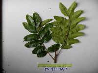 951801[1297968]Weiblen, G.D. YS4F04502010-09-09 Papua New Guinea, Morobe, Yawan Village, -6.16255 146.839933, 1721m |
MIN:Plants | 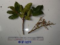 951806[1298044]Weiblen, G.D. YS3F03792010-08-21 Papua New Guinea, Morobe, Yawan Village, -6.16255 146.839933, 1721m |
MIN:Plants |  149691[1302056]Wood. J, Medley 39321889-12-00 South Africa, Natal, Liddesdale, near Maritzburg |
MIN:Plants |  553019[1302057]Sidey, James L. 30161956-10-00 South Africa, Collected Bains Drift, Masitzburg, Natal |
MIN:Plants |  582151[1302059]Sidey, James L. 36441962-10-00 South Africa, Collected Maitzburg, Natal |
MIN:Plants |  575903[1302061]Sidey, James L. 35181961-01-00 South Africa, Collected Amersfoost, E Tol. |
MIN:Plants |  569773[1302062]Sidey, James L. 36071961-12-00 South Africa, Collected Bathurst District, E. Cape |
MIN:Plants |  149844[1302063] 7891880-11-00 South Africa, Yaunde |
MIN:Plants |  577862[1302065]Troupin, G 115911959-03-14 Rwanda, Region du Mutara, 1400 - 1450m |
MIN:Plants |  582343[1302066]Sidey, James L. 33521959-02-00 South Africa, Collected Umkomaas Valley, NAtal |
MIN:Plants |  582402[1302067]Sidey, James L. 34661960-04-00 South Africa, Collected Vally busch, Tugela valley |
MIN:Plants |  582175[1302070]Sidey, James L. 36891963-03-00 South Africa, Collected E. Cape, Bathurst District |
MIN:Plants |  150081[1302071] 8941880-04-00 South Africa |
MIN:Plants | Astronium graveolens NULL 939736[]P 12011-07-07 Costa Rica, Guanacaste, Liberia, , 10.84 -85.61, 320m |
MIN:Plants | Spondias mombin NULL 939743[]P 22011-07-07 Costa Rica, Guanacaste, Liberia, , 10.84 -85.61, 320m |
MIN:Plants | 149647[]Curtiss, A. 2711904-00-00 Cuba, Near Nueva Gerona, Isla de Pinos |
MIN:Plants |  775109[1299099]Lane, C. 651977-05-17 Puerto Rico, Orocovis, west side of Rio Bautia |
MIN:Plants |  920756[]Whitfeld, T.J.S. PA2B01012008-08-13 Papua New Guinea, Madang, Wanang Village, -5.237483 145.115733, 129m |
MIN:Plants |  912259[]Weiblen, G.D. & Binatang Research Center WS3C12212006-12-05 Papua New Guinea, Madang, Wanang Village, -5.229583 145.178467, 115m |
MIN:Plants | Rhus aromatica Aiton 426826[]US Nat. Arboretum staff 31974-00-00 United States, District of Columbia, USNA |
MIN:Plants | Rhus aromatica Aiton []Wampler, C. GW13512002-07-29 United States, Colorado, Gunnison, Private property, along Rotcap Creek, Pitkin Mesa, 38.954778 -107.269944, 1808m |
MIN:Plants | Rhus aromatica Aiton []Wampler, C. GW13842002-07-29 United States, Colorado, Delta, Private property, along Rotcap Creek, Pitkin Mesa, 38.870528 -107.638472, 1808m |
MIN:Plants | Rhus aromatica Aiton []Cosand, D. GW24532005-06-29 United States, Colorado, Delta, Private property, along Rotcap Creek, Pitkin Mesa, 38.870528 -107.638472, 1808m |
MIN:Plants | Rhus aromatica Aiton []Weiblen, G. D. GW13092001-07-28 United States, Colorado, Delta, Rotcap Creek, property of James & Barbara Thomson, near Paonia, 38.85 -107.616667, 1670m |
MIN:Plants | Rhus trilobata Nuttall 478583[]Bright, R. 74-781974-00-00 United States, Idaho, Franklin, [no further data] |
MIN:Plants | Rhus trilobata Nuttall 492419[]Williams, M. s.n.1982-00-00 United States, Nevada, Washoe Co. -- cultivated |
MIN:Plants | Rhus trilobata Nuttall 478575[]Davis, Owen s.n.1981-00-00 United States, Texas, Dallam, Dallam Co. |
MIN:Plants | Rhus trilobata Nuttall 966477[1359254]Sister Saint Mark Wirtz 1946-07-14 United States, South Dakota, Hangman's Hill |
MIN:Plants | Rhus glabra L. 428973[]Smith, Welby 288792000-08-02 United States, Minnesota, Goodhue, Goodhue County ... Frontenac State Park, about 2 miles N-NE of Frontenac ... T 112N R 13W NW1/4 of SE1/4 of Sec 2;Frontenac State Park;112N;13W;02, 44.5341667 -92.335 |
MIN:Plants | Rhus glabra L. 461912[]Smith, Welby 271781998-06-01 United States, Minnesota, Mille Lacs, Kunkel Wildlife Management Area. Mille Lacs County ... Kunkel State Wildlife Management Area, about 4.5 miles west of Princeton ...T36N R27W SW1/4 of NE1/4 of Sec 26. 036N 27W 26, 45.5841667 -93.6638889 |
MIN:Plants | Rhus glabra L. 455553[]Smith, Welby 279681999-07-09 United States, Minnesota, Kandiyohi, Sibley State Park. Kandiyohi County ... Sibley State Park, about 12 miles north of Wilmar [sic] ... north side of Andrew Lake ... T 121N R 35W NE1/4 of NE1/4 of Sec 2. 121N 35W 2, 45.3233333 -95.0305556 |
MIN:Plants | Rhus glabra L. 898327[]Smith, Welby 282821999-09-01 United States, Minnesota, Koochiching, Koochiching County...About 6 miles north of Loman...T 159N R25W SE1/4 of SE1/4 of Sec 10;;159N;25W;10, 48.6019444 -93.8241667 |
MIN:Plants | Rhus glabra L. 511120[]Smith, Welby 286692000-07-09 United States, Minnesota, Ramsey, Ramsey County ... Swede's Hollow City Park, in St. Paul ... T 29N R22W SE1/4 of NW1/4 of Sec 32.;;029N;22W;32, 44.9577778 -93.0763889 |
MIN:Plants | Rhus glabra L. 505357[]McNaughton, Lynn 1572003-09-23 United States, Minnesota, Waseca, Maplewood Park: Waseca County ... Along sunny entrance road ... SE1/4 of SW1/4 of Sect. 9, T107N, R22W.;Maplewood County Park;107N;22W;09, 44.087663 -93.476763 |
MIN:Plants | Rhus glabra L. 474197[]Scott, P. 11521999-08-16 United States, Minnesota, Cook, Cook Co.; Superior Hiking Trail just west of junction with Gunflint Trail. T61N R1E sec. 16 NENWSW.;North Shore / Superior National Forest;061N;01E;16, 47.766373 -90.328947 |
MIN:Plants | Rhus glabra L. 477201[]Smith, Welby 171901990-07-11 United States, Minnesota, Dodge, Schletty Wildlife Management Area. Dodge County ... Schletty State Wlidlife Management Area , about 4 miles northwest of Mantorville ... T108N R17W SE1/4 of SW1/4 of Sec 36. 108N 17W 36, 44.1125 -92.8122222 |
MIN:Plants | Rhus glabra L. 898322[]Smith, Welby 280611999-07-22 United States, Minnesota, Cottonwood, Cottonwood County...About 6 miles N-NE of Heron Lake (town)...Des Moines River...T105N R37W NE1/4 of NW1/4 of Sec 28;;105N;37W;28, 43.8763889 -95.2930556 |
MIN:Plants | Rhus glabra L. 917199[]Smith, Welby 224451993-06-18 United States, Minnesota, Grant, Grant County ... South side of Ask Lake, about 1.5 miles east-southeast of Ashby ... T130N R41W NW1/4 of SW1/4 of Sec 12;;130N;41W;12, 46.0847222 -95.7886111 |
MIN:Plants | Rhus glabra L. 913801[]Smith, Welby 242781994-07-02 United States, Minnesota, Polk, Polk County... On Nancy Sather's farm, about 1.25 miles west of Polk-Clearwater County line... T147N R39W NE1/4 of SE1/4 of Sec 11. 147N 39W 11, 47.5633333 -95.5802778 |
MIN:Plants | Rhus glabra L. 914873[]Smith, Welby 226791993-07-01 United States, Minnesota, Otter Tail, Maplewood State Park. Otter Tail County ... Maplewood State Park, about 5 miles east-southeast of Pelican Rapids ... T135N R 42W SE1/4 of NE1/4 of Sec 9. 135N 42W 9, 46.5225 -95.9727778 |
MIN:Plants | Rhus glabra L. 510249[]US Nat. Arboretum staff 77-91977-00-00 United States, Maryland, Anne Arundel, [no further data] |
MIN:Plants | Rhus glabra L. 475273[]Smith, Welby 280461999-07-21 United States, Minnesota, Lac Qui Parle, Lac Qui Parle State Park. Lac Qui Parle County ... In Lac Qui Parle State Park ... along the Lac Qui Parle River ... T 118N R 42W SE1/4 of NE1/4 of Sec 15. 118N 42W 15, 45.0325012 -95.901947 |
MIN:Plants | Rhus glabra L. 461985[]Peters, Emily 32006-10-01 United States, Minnesota, Hennepin, Hennepin Co, Midtown Greenway Bike Path west of Lake Calhoun.;;;;, 44.9483333 -93.3208333, 265m |
MIN:Plants | Rhus glabra L. 899511[]Smith, Welby 273101998-06-29 United States, Minnesota, Itasca, Itasca County...At the north side of Round Lake...T 148N R 27W NW1/4 of SW1/4 of Sec 18;Chippewa National Forest / Leech Lake Indian Reservation;148N;27W;18, 47.6327778 -94.1602778 |
MIN:Plants | Rhus glabra L. 455555[]Smith, Welby 119551986-07-02 United States, Minnesota, Sherburne, Sherburne National Wildlife Refuge. Sherburne County ... Sherburne National Wildlife Refuge, about 2-1/2 miles southeast of Santiago ... NE1/4 SW1/4 section 23, T 35N R 28W. 035N 28W 23, 45.5074997 -93.7938919 |
MIN:Plants | Rhus glabra L. 484628[]Smith, Welby 157561989-07-17 United States, Minnesota, Benton, Benton Co.; About 2 miles east of Watab; SE1/4 SE1/4 sec. 24, T 37N R 31W;;037N;31W;24, 45.6788902 -94.1347198 |
MIN:Plants | Rhus glabra L. 920279[]Smith, Welby 222721993-06-03 United States, Minnesota, Sibley, Vale Wildlife Management Area. Sibley County...Vale State Wildlife Management Area; in the valley of High Island Creek, about 2.5 miles southwest of its confluence with the Minnesota River...T 113N R 26W NE1/4 of SW1/4 of Sec 27. 113N 26W 27, 44.5625 -93.9427778 |
MIN:Plants | Rhus glabra L. 899510[]Smith, Welby 272971998-06-29 United States, Minnesota, Itasca, Itasca County...Scenic State Park, about 3 miles SE of Bigfork...T 60N R 26W SE1/4 of NE1/4 of sec 1;Scenic State Park;060N;26W;01, 47.7208333 -93.5805556 |
MIN:Plants | Rhus glabra L. 428964[]Smith, Welby 279611999-07-01 United States, Minnesota, Washington, Washington County ... Afton State Park; about 7 miles NE of Hastings ... T 27N R 20W NE1/4 of NW1/4 of Sec 11;Afton State Park;027N;20W;11, 44.8466682 -92.7705536 |
MIN:Plants | Rhus glabra L. 149724[]Ballard, C. 31641901-08-15 United States, Minnesota, Clay, Moorhead;;N;;, 46.873852 -96.767581 |
MIN:Plants | Rhus glabra L. 149729[]Taylor, B. T8201891-07-00 United States, Minnesota, Pope, Glenwood;;N;;, 45.650239 -95.389758 |
MIN:Plants | Rhus glabra L. 149800[]Sheldon, Edmund S15131891-08-00 United States, Minnesota, Lincoln, Lake Benton;;109N;45W;, 44.24108 -96.26172 |
MIN:Plants | Rhus glabra L. 149801[]Goldsmith, G. G1211912-00-00 United States, Minnesota, Rice, Northfield;;;;, 44.458298 -93.161604 |
MIN:Plants | Rhus glabra L. 149802[]Rosendahl, C. 6621902-07-01 United States, Minnesota, Houston, Spring Grove;;101N;07W;, 43.543923 -91.6707 |
MIN:Plants | Rhus glabra L. 149803[]Manning, Sara s.n.1882-06-20 United States, Minnesota, Wabasha, Lake City;;111N;12W;, 44.4081 -92.252454 |
MIN:Plants | Rhus glabra L. 149804[]Moyer, Lycurgus s.n.1894-08-24 United States, Minnesota, Swift, Lake Hazel [Hassel], Swift Co.;;122N;39W;, 45.368739 -95.562242 |
MIN:Plants | Rhus glabra L. 149805[]Holzinger, John s.n.1886-07-00 United States, Minnesota, Winona, Winona;;N;;, 43.946392 -91.684856 |
MIN:Plants | Rhus glabra L. 149806[]Menzel, Max 16861895-06-00 United States, Minnesota, Pipestone, Pipestone [assuming the quarry area; town generally noted as "Pipestone City" by collector];Pipestone National Monument;106N;46W;01, 44.01585 -96.31767 |
MIN:Plants | Rhus glabra L. 149807[]Oestlund, O. s.n.1886-07-00 United States, Minnesota, Hennepin, Minneapolis;;N;;, 44.979965 -93.263836 |
MIN:Plants | Rhus glabra L. 149808[]Arthur, J.; et al. B2541886-07-22 United States, Minnesota, Saint Louis, Vermilion Lake;;;;, 47.898947 -92.420382 |
MIN:Plants | Rhus glabra L. 149810[]Campbell, Jennie s.n.1897-07-00 United States, Minnesota, Otter Tail, Clitherall;;N;;, 46.274961 -95.631156 |
MIN:Plants | Rhus glabra L. 149811[]Campbell, Jennie s.n.1897-07-00 United States, Minnesota, Otter Tail, Clitherall;;N;;, 46.274961 -95.631156 |
MIN:Plants | Rhus glabra L. 149812[]Ballard, C. B84n1891-06-00 United States, Minnesota, Carver, Chaska;;N;;, 44.789407 -93.602179 |
MIN:Plants | Rhus glabra L. 149813[]MacMillan, C.; et al. MS12881894-07-00 United States, Minnesota, Lake of the Woods, Oak Point;Pine & Curry Islands Scientific Natural Area;162N;31W;06, 48.87976 -94.69025 |
MIN:Plants | Rhus glabra L. 149814[]Menzel, Max 16861895-06-00 United States, Minnesota, Pipestone, Pipestone [assuming the quarry area; town generally noted as "Pipestone City" by collector];Pipestone National Monument;106N;46W;01, 44.01585 -96.31767 |
MIN:Plants | Rhus glabra L. 149815[]Sheldon, Edmund s.n.1895-06-00 United States, Minnesota, Hennepin, Ft. Snelling;Fort Snelling Military Reservation;028N;23W;, 44.905162 -93.166462 |
MIN:Plants | Rhus glabra L. 149816[]Sheldon, Edmund s.n.1895-06-00 United States, Minnesota, Hennepin, Prospect Park, Minneapolis;;N;;, 44.9685 -93.21505 |
MIN:Plants | Rhus glabra L. 149817[]Aiton, G. s.n.1891-08-00 United States, Minnesota, Hennepin, near Minneapolis;;N;;, 44.979965 -93.263836 |
MIN:Plants | Rhus glabra L. 149818[]Frost, W. F4301892-08-00 United States, Minnesota, Kandiyohi, Spicer;;N;;, 45.23302 -94.940009 |
MIN:Plants | Rhus glabra L. 149819[]Moyer, Lycurgus 30-11891-00-00 United States, Minnesota, Chippewa, Montevideo;;117N;40W;, 44.934626 -95.675774 |
MIN:Plants | Rhus glabra L. 149820[]Burglehaus, F. s.n.1892-07-00 United States, Minnesota, Hennepin, Loc. near Minneapolis;;N;;, 44.979965 -93.263836 |
MIN:Plants | Rhus glabra L. 149821[]Menzel, Max s.n.1895-07-00 United States, Minnesota, Pipestone, Pipestone [assuming the quarry area; town generally noted as "Pipestone City" by collector];Pipestone National Monument;106N;46W;01, 44.01585 -96.31767 |
MIN:Plants | Rhus glabra L. 149822[]Menzel, Max s.n.1895-06-00 United States, Minnesota, Pipestone, Pipestone [assuming the quarry area; town generally noted as "Pipestone City" by collector];Pipestone National Monument;106N;46W;01, 44.01585 -96.31767 |
MIN:Plants | Rhus glabra L. 149823[]Taylor, B. T5241891-06-00 United States, Minnesota, Waseca, Janesville;;N;;, 44.116078 -93.708004 |
MIN:Plants | Rhus glabra L. 220058[]Linnaean Club, U of M, 2761943-07-10 United States, Minnesota, Rice, Nerstrand Woods, Rice Co, S of main road;Nerstrand Woods State Park;110N;19W;, 44.327064 -93.100886 |
MIN:Plants | Rhus glabra L. 224578[]Rosendahl, C. 53641927-08-13 United States, Minnesota, Houston, Spring Grove; Sec. 22;;101N;07W;22, 43.536807 -91.660825 |
MIN:Plants | Rhus glabra L. 246160[]Chandonnet, Z. s.n.1912-08-24 United States, Minnesota, Becker, Detroit;;N;;, 46.817222 -95.845278 |
MIN:Plants | Rhus glabra L. 246165[]Chandonnet, Z. s.n.1911-06-27 United States, Minnesota, Otter Tail, Ottertail River, Perham;;N;;, 46.476958 -95.575157 |
MIN:Plants | Rhus glabra L. 282441[]Buell, Murray 4891932-07-22 United States, Minnesota, Clearwater, Itasca Park, E shore of Squaw Lake; SE1/4 NW1/4 Sec. 5 T143N R36W;Itasca State Park;143N;36W;5, 47.231426 -95.265784 |
MIN:Plants | Rhus glabra L. 282677[]Swanson, Gustav s.n.1932-08-14 United States, Minnesota, Lake of the Woods, Northwest Angle;Northwest Angle;N;;, 49.263135 -95.065972 |
MIN:Plants | Rhus glabra L. 294395[]Chandonnet, Z. s.n.1913-07-09 United States, Minnesota, Becker, Detroit;;N;;, 46.817222 -95.845278 |
MIN:Plants | Rhus glabra L. 346307[]Grant, Martin 68121936-08-21 United States, Minnesota, Becker, Itasca Park. Becker Co. De Soto Lake; NW1/4 NE1/4 Sec. 3 T142N R36W;Itasca State Park;142N;36W;3, 47.145259 -95.222785 |
MIN:Plants | Rhus glabra L. 352713[]Jukkola, E. 531937-07-05 United States, Minnesota, Hennepin, East River Road, S of Pioneer Hall, Minneapolis;;N;;, 44.970281 -93.230147 |
MIN:Plants | Rhus glabra L. 356967[]Stevenson, J. 1411912-07-11 United States, Minnesota, Beltrami, Bemidji;;N;;, 47.473563 -94.880277 |
MIN:Plants | Rhus glabra L. 360489[]Lakela, Olga 39311940-08-04 United States, Minnesota, Saint Louis, at Burntside Lake, Burntside Lodge;Superior National Forest;063N;13W;23, 47.925804 -91.956213 |
MIN:Plants | Rhus glabra L. 366432[]Rosendahl, C.; et al. 73701939-09-14 United States, Minnesota, Yellow Medicine, Minnesota Valley, 1 mi south of Granite Falls;;115N;39W;, 44.760345 -95.543577 |
MIN:Plants | Rhus glabra L. 369236[]Lakela, Olga 46441941-07-29 United States, Minnesota, Lake, Blueberry Hill near Little Marais;;N;;, 47.410745 -91.110162 |
MIN:Plants | Rhus glabra L. 369834[]Moore, John; et al. 146221941-07-05 United States, Minnesota, Wright, 1 mi. NW of Annandale, Wright Co.;;121N;28W;, 45.28286 -94.19955 |
MIN:Plants | Rhus glabra L. 370874[]Moore, John; Moore, Marjorie 134311940-09-01 United States, Minnesota, Dakota, 1/2 mi S of Inver Grove;;N;;, 44.848056 -93.042778 |
MIN:Plants | Rhus glabra L. 371973[]Moore, John; et al. 147811941-07-07 United States, Minnesota, Becker, Becker County...SE shore of Cotton Lake; Erie Twp.;;139N;40W;12, 46.868486 -95.677966 |
MIN:Plants | Rhus glabra L. 373775[]Moore, John; et al. 150361941-08-08 United States, Minnesota, Aitkin, 2 mi W of Aitkin. Aitkin Co.;;;;, 46.533005 -93.752339 |
MIN:Plants | Rhus glabra L. 381375[]Moore, John; et al. 153511942-06-19 United States, Minnesota, Steele, Near hwy 65, 2 mi S of Owatonna. Steele Co.;;;;, 44.054885 -93.226044 |
MIN:Plants | Rhus glabra L. 381489[]Moore, John; et al. 153881942-06-20 United States, Minnesota, Olmsted, 1 mi N of Rochester on hwy 63. Olmsted Co.;;;;, 44.03615 -92.46972 |
MIN:Plants | Rhus glabra L. 383095[]Moore, John 157721943-06-18 United States, Minnesota, Dakota, 2 mi NW of Hastings, S side of Mississippi River;;115N;17W;, 44.739075 -92.862655 |
MIN:Plants | Rhus glabra L. 383197[]Moore, John 158541943-06-25 United States, Minnesota, Washington, Ridge along the St. Croix, l.5 mi. S of Bayport.;;029N;20W;, 44.99172 -92.814208 |
MIN:Plants | Rhus glabra L. 393028[]Lakela, Olga 73521947-09-05 United States, Minnesota, Saint Louis, S shore of Ely Lake, Eveleth;;N;;, 47.450206 -92.486018 |
MIN:Plants | Rhus glabra L. 393435[]Lakela, Olga 69281947-07-12 United States, Minnesota, Saint Louis, Cloquet River banks at the dam.;;N;;, 46.990758 -92.231161 |
MIN:Plants | Rhus glabra L. 406376[]Jones, George Neville 184861946-07-25 United States, Minnesota, Saint Louis, Armstrong Lake, near Ely;;N;;, 47.844609 -92.115349 |
MIN:Plants | Rhus glabra L. 406377[]Jones, George Neville 185151946-08-01 United States, Minnesota, Saint Louis, Armstrong Lake, near Ely;;N;;, 47.844609 -92.115349 |
MIN:Plants | Rhus glabra L. 407128[]Lakela, Olga 95671949-08-29 United States, Minnesota, Saint Louis, Lake Kabetogama, near Gappas Landing;Voyageurs National Park;N;;, 48.457735 -92.984115 |
Google Map
Google Maps is a web mapping service provided by Google that features a map that users can pan (by dragging the mouse) and zoom (by using the mouse wheel). Collection points are displayed as colored markers that when clicked on, displays the full information for that collection. When multiple species are queried (separated by semi-colons), different colored markers denote each individual species.