University of Minnesota
http://www.umn.edu/
612-625-5000
http://www.umn.edu/
612-625-5000
Minnesota Biodiversity Atlas
Bell Museum
Dataset: MIN-Plants
Taxa: Bromeliaceae
Search Criteria: excluding cultivated/captive occurrences
Bell Museum plants | |
 MIN:Plants |  476065[1345047][illegible] 351081989-01-14 Bolivia, Inquisivi, Following the slopes E of Communidad Micayani to the Rio Khokhoni more or less to the junction with a fork flowing down from Communidad Yamora, and following the Rio Khokhoni upstream 1 km from this point, ca. 4 km SE from Inquisivi., -17.02554 -67.056624, 2680m |
MIN:Plants |  436865[1345143]Stevens, Warren Douglas 123801979-02-21 Nicaragua, Zelaya, Along road from Constancia to Laguna Siempreviva., 13.866667 -84.516667, 290 - 360m |
MIN:Plants |  438562[1345144;1343905]Stevens, Warren Douglas 10,0091978-08-16 Nicaragua, Managua, Along new road from Hwy. 1 (N of San Jacinto entrance) to San Fransisco del Carnicero, ca 4.8 km W of Hwy 1;, 12.339997 -86.020686, 100m |
MIN:Plants |  Tillandsia baileyi Rose ex Small 448244[1299139]O'Brien, Ruth 13141982-06-05 United States, Texas, Kenedy, SE of Sarita on Kenedy Ranch;;;;, 27.195453 -97.743843 |
MIN:Plants | Tillandsia fasciculata Swartz 515258[]Stevens, Warren Douglas; et al. 144781979-10-01 Nicaragua, Esteli, Salto de Estanzuela, Rio Estanzuela ca 6 km S of Esteli;;;;, 13.0166664 -86.3333359, 920 - 1020m |
MIN:Plants |  Tillandsia fasciculata Swartz 245360[1345104] C171971917-02-23 United States, Royal Palm Hammock., 25.9833 -81.5833 |
MIN:Plants |  Tillandsia fasciculata Swartz 488411[1345159]Pipoly, John, J. 42221979-03-09 Nicaragua, Zelaya, Cerro Waylawás, E side of central range., 13.655681 -84.817744, 100 - 200m |
MIN:Plants |  Tillandsia fasciculata Swartz 488412[1345160]Grijalva, A. 14111982-10-09 Nicaragua, Matagalpa, Chapel of Es-Equipulas, situated 20 km NE of El Tuma (between Río Wasaka and Río Bulbul); ca 13., 13.189679 -85.613782, 500m |
MIN:Plants |  Tillandsia fasciculata Swartz 540899[1345161]Stevens, Warren Douglas 152401979-10-25 Nicaragua, N slope of Volcán Yalí; Coffee plantations on lower slopes, upper slopes with tall closed forest., 13.269646 -86.124608, 1200 - 1400m |
MIN:Plants |  Tillandsia fasciculata Swartz 436864[1345162]Araquistain, M. 146161979-10-03 Nicaragua, Departamento Boaco: upper south west slope of Cerro Mombachito, south of road between Boaco and Camoapa, 12.4 -85.55, 900 - 1000m |
MIN:Plants |  Tillandsia fasciculata Swartz 515308[1345163]Stevens, Warren Douglas 12,0431979-02-12 Nicaragua, Matagalpa, Lower W slope of Cerro Musun, Quebrada El Jobo, a tributary of Río Paiwas., 12.985186 -85.242346, 300m |
MIN:Plants |  Tillandsia fasciculata Swartz 962470[1345158]Stevens, Warren Douglas 144781979-10-01 Nicaragua, Departamento ESTELI: Salto de Estanzuela, Rio Estanzuela ca 6 km S of Esteli, 13.016667 -86.333333, 920 - 1020m |
MIN:Plants |  Bilbergia pyramidalis Lindley 508105[1299159]Cholewa, A.F. 2598 United States, Minnesota, Wright |
MIN:Plants |  Hechtia pringlei Robinson & Greenman 84963[1001302]Pringle, C.G. 46371894-05-13 Mexico, Oaxaca, near Oaxaca, 17.051561 -96.726083 |
MIN:Plants |  Hechtia tehuacana Robinson 88688[1001303]Pringle, C.G. 85781901-08-02 Mexico, Puebla, Hills near Tehuacan, 18.454247 -97.396205 |
MIN:Plants |  Tillandsia balbisiana Schult. & Schult. f. 245351[1345103] C171981917-02-23 United States, Royal Palm Hammock., 25.9833 -81.5833 |
MIN:Plants |  Tillandsia balbisiana Schult. & Schult. f. 459618[1345145]Stevens, Warren Douglas 44381977-11-06 Nicaragua, Department de Masaya: Parque Nacional Volcán Masaya, near west shore of Laguna de Masaya, ca. 7.1 kilometers south of Highway 4 [[Masaya Department: Masaya Volcano National Park, near west shore of Laguna de Masaya, ca. 7.1 kilometers south of Highway 4]], 11.985222 -86.160729, 140 - 200m |
MIN:Plants |  Tillandsia balbisiana Schult. & Schult. f. 493876[1345146]Sandino, J.C. 17821981-12-17 Nicaragua, Rio San Juan, W de San Carlos, 11.134363 -84.833771, 30 - 35m |
MIN:Plants |  Tillandsia paucifolia Baker 488107[1345187]Stevens, Warren Douglas 112771978-12-26 Nicaragua, Departamento de Matagalpa: ca. 1.8 km SW of ford of Rio Grande de Matagalpa on road to Terrabona, 12.633333 -86.016667, 410m |
MIN:Plants |  Tillandsia paucifolia Baker 515317[1345188]Stevens, Warren Douglas 171071980-05-09 Nicaragua, Departamento de Managua: along road from Hwy 1 (N of San Jacinto entrance) to San Francisco del Carnicero, ca 4.8 km W of Hwy 1, 12.503214 -86.300621, 0 - 100m |
MIN:Plants |  Tillandsia recurvata (L.) L. 476511[1345105]Cummius, D. s.n. United States, Texas, 5 mi. V. Calallen, Co. Rd. 73., 27.867522 -97.623051 |
MIN:Plants |  Tillandsia recurvata (L.) L. 448243[1345106]A., R.S. s.n.1982-05-02 United States, Texas, San Patricio, Behind old stone interpretive center, Corpus Christi Lake State Park, S.W. of Mathis., 28.061435 -97.873562 |
MIN:Plants |  Tillandsia recurvata (L.) L. 448241[1345107]A., R.S. s.n.1978-03-20 United States, Texas, Aransas National Wildlife Sanctuary, S.E. of Rockport., 28.0167 -97.05 |
MIN:Plants |  Tillandsia recurvata (L.) L. 438251[1345190]Araquistain, M. 20121980-04-14 Nicaragua, Departamento de Madriz: Falda W del cerro Volcan de Somoto (Tepesomoto). Camino entre San Lucas y la hacienda El Volcan, 2 km al NE de San Lucas [Madriz Department: W skirt of the Volcan de Somoto hill (Tepesomoto). Road between San Lucas and the El Volcan farm, 2 km NE of San Lucas], 13.416667 -86.583333, 800 - 900m |
MIN:Plants |  Tillandsia recurvata (L.) L. 493122[1345191]Stevens, Warren Douglas 155121979-11-14 Nicaragua, Esteli, Departamento Esteli: 4.9-7.6 km NE of Hwy 1 at Esteli along road to Yali, 13.184798 -86.28655, 820 - 1100m |
MIN:Plants |  Tillandsia recurvata (L.) L. 493121[1345192]Stevens, Warren Douglas 112031978-12-25 Nicaragua, Esteli, Departamento de Esteli: km 163 on Hwy. 1 ca. 11.2 km N of entrance to Esteli, 13.216667 -86.383333, 920m |
MIN:Plants |  Tillandsia recurvata (L.) L. 493137[1345193]Stevens, Warren Douglas 158911979-11-19 Nicaragua, Esteli, Departamento Esteli: along road from Condega to Yali, ca 18.9 km NE of Hwy 1 and ca 1 km SW of Daraili, 13.383333 -86.266667, 980 - 1020m |
MIN:Plants |  Tillandsia usneoides (L.) L. 830423[1345108]Nelson, John B. 12,1141992-02-19 United States, South Carolina, Hampton, Avenue on N side of Webb Wildlife Center off S-20, W of Garnett., 32.591248 -81.3113 |
MIN:Plants |  Tillandsia usneoides (L.) L. 448240[1345109]Koch, C.E. s.n.1937-04-01 United States, South Carolina, Charleston, 32.776566 -79.930922 |
MIN:Plants |  Tillandsia usneoides (L.) L. 448242[1345110]A., R.S. s.n.1982-03-25 United States, Texas, San Patricio, Pecan Mott Area, Welder Refuge, 31.693764 -100.441484 |
MIN:Plants |  Tillandsia usneoides (L.) L. 243168[1345111] C171341917-02-21 United States, Florida, Royal Palm Hammock., 25.9833 -81.5833 |
MIN:Plants |  Tillandsia usneoides (L.) L. 243167[1345112] C162051916-03-03 United States, Florida, Dade, Royal Palm Hammock. 14 mi S.W. Florida City., 25.994263 -81.59175 |
MIN:Plants |  Tillandsia usneoides (L.) L. 243165[1345113] C1971919-01-06 United States, Florida, near Lakeland., 28.039465 -81.949804 |
MIN:Plants |  Tillandsia usneoides (L.) L. 334663[1345115] s.n. United States |
MIN:Plants |  Tillandsia usneoides (L.) L. 389633[1345116]Holland, Esther s.n.1905-04-00 United States, Florida, Volusia |
MIN:Plants |  Tillandsia usneoides (L.) L. 355944[1345117]Mayer, L.R. s.n.1904-03-10 United States, Texas, Bastrop |
MIN:Plants |  Tillandsia usneoides (L.) L. 475820[1345118]Nelson, John B. 13,3521992-07-28 United States, South Carolina, Richland, Fort Jackson Army Installation; on N side of Sargent Jasper Road near Twin Lakes: off Semmes Road., 33.994724 -80.907674 |
MIN:Plants |  Tillandsia usneoides (L.) L. 588897[1345119]Munns, C.E. 1121/21963-10-26 United States, Virginia, Seashore State Park. Near Virginia Beach. Northernmost limit of Tillandsia., 36.867201 -75.971807 |
MIN:Plants |  Tillandsia usneoides (L.) L. 243171[1345120]Harris, Arthur J. C173601917-03-15 United States, Florida, Sykis Hammock |
MIN:Plants |  Tillandsia usneoides (L.) L. 243170[1345121]Harris, J. Arthur C17191917-02-09 United States, Florida, Orange Grove, Miami, 25.774266 -80.193659 |
MIN:Plants |  Tillandsia usneoides (L.) L. 243172[1345122]Harris, J. Arthur C175521917-04-01 United States, Florida, the narrows, Indian River, 27.405328 -80.290347 |
MIN:Plants |  Tillandsia usneoides (L.) L. 243173[1345123] C174141917-03-19 United States, Hattie Bauer Hammock. [Hattie Bauer Hammock Preserve, Homestead], 25.518455 -80.44412 |
MIN:Plants |  Tillandsia usneoides (L.) L. 410600[1345124]Anderson, Alexander P. 19991914-03-15 United States, Florida, Daytona [Daytona Beach], 29.210815 -81.022833 |
MIN:Plants |  Tillandsia usneoides (L.) L. 406031[1345125]Spetzman, L. s.n.1942-11-00 United States, Texas, Bexar, Medina, Comal, Fort San Houston. San Antonio, 29.465053 -98.476456 |
MIN:Plants | Tillandsia usneoides (L.) L. 246818[1345126] United States |
MIN:Plants |  Tillandsia usneoides (L.) L. 492139[1345215]Grijalva, A. 19381982-11-24 Nicaragua, Granada. Isla Zapatera, costado noroeste de Hacienda El Cerro [[Grenade. Zapatera Island, northwest side of Hacienda El Cerro]], 11.74 -85.831, 400 - 525m |
MIN:Plants |  Tillandsia usneoides (L.) L. 491634[1345216]Araquistain, M. 22961980-04-18 Nicaragua, Departamento de Nueva Segovia: Cerro El Achiote, 7 kilometers al norte de El Jícaro [[Nueva Segovia Department: Cerro El Achiote, 7 kilometers north of El Jícaro]], 13.766667 -86.133333, 700 - 1000m |
MIN:Plants |  Tillandsia usneoides (L.) L. 491616[1345217]Nee, Michael 277331983-09-01 Nicaragua, 14 kilometers south of Esteli, about 5 kilometers from main road (highway 1), on road to San Francisco "Tierra Blanca", 12.966667 -86.316667, 1100m |
MIN:Plants |  Tillandsia usneoides (L.) L. 492454[1345218]Grijalva, A. 8191982-08-13 Nicaragua, Granada. Isla Zapatera, Cerro El Llano (falda norte) [[Zapatera Island, Cerro El Llano (north skirt)]], 11.74 -85.831, 100m |
MIN:Plants |  Tillandsia usneoides (L.) L. 492580[1345219]Nee, Micheal 276631985-08-30 Nicaragua, Cerro El Piacho above Hotel Santa Maria de Ostuma, 13.008333 -85.916667, 1350 - 1585m |
MIN:Plants |  Tillandsia usneoides (L.) L. 438848[1345220]Nee, Michael 279801983-09-12 Nicaragua, Boaco. 1-2 kilometers south east of Santa Maria, along Rio Fonseca, 12.633333 -85.766667, 500m |
MIN:Plants |  Tillandsia usneoides (L.) L. 459529[1345221]Araquistain, M. 20761980-04-15 Nicaragua, Departamento de Madriz: Falda west del cerro Volcán de Somoto (Tepesmoto). [[Madriz Department: West slope of the Volcán de Somoto hill (Tepesmoto).]], 13.416667 -86.583333, 900 - 1100m |
MIN:Plants |  Tillandsia usneoides (L.) L. 962562[1345222]Stevens, Warren Douglas 11,2041978-12-25 Nicaragua, Departamento de Esteli: kilometer 163 on highway 1, 11.2 kilometers north of entrance to Estelí, 13.216667 -86.383333, 920m |
MIN:Plants |  Tillandsia usneoides (L.) L. 85049[1345223]Ricksecker, Alfred E. 2671896-02-12 Virgin Islands, U.s., Signal hill, Saint Thomas Island, 17.735151 -64.775932 |
MIN:Plants |  Tillandsia usneoides (L.) L. 85048[1345224]Pollard, Charles L. 2751902-02-14 Cuba, Santiago, Vicinity of Santiago City., 22.685833 -81.055833 |
MIN:Plants |  Tillandsia usneoides (L.) L. 568275[1345225]Darnell, R.M. s.n.1951-05-19 Mexico, Aquatic Plants and Flood plain plants of the Rio Sabinas (Panuco-Tamesi drainage - souther Tamaulipas), 27.536947 -100.701954 |
MIN:Plants |  Tillandsia usneoides (L.) L. 294231[1345226]Yuncker, T.G. 48621934-07-30 Honduras, Cortez, 15.633333 -88.3, 2100m |
MIN:Plants |  Tillandsia usneoides (L.) L. 965883[1356641]J.E. Woolsey 1925-02-00 United States, Louisiana, Audubon Park, 29.93076 -90.126462 |
MIN:Plants | 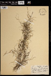 Tillandsia usneoides (L.) L. 0967744[1368311]R.Hinds s.n.1938-05-01 United States, Texas |
MIN:Plants | 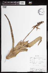 Aechmea angustifolia Poepp. & Endl. 438202[1345048]Rueda, Ricardo 18201994-07-06 Nicaragua, Rio San Juan, Spanish Creek, spout of Agua Negra, branch of Rio Indio., 0 - 100m |
MIN:Plants | 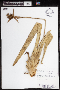 Aechmea angustifolia Poepp. & Endl. 438201[1345049]Rueda, Ricardo 25531995-01-05 Nicaragua, Rio San Juan, Caño Negro and Caño Pescado. Greytown, 11.90864 -83.893528 |
MIN:Plants | 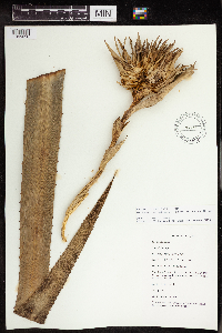 Aechmea magdalenae (André) André ex Baker 540789[1345050]Salick 7867 Nicaragua, Rio San Juan. "La Lupe" near Rio Santa Cruz., 11.017941 -84.421127 |
MIN:Plants |  Aechmea pubescens Baker 459561[1345051]Rueda, Ricardo 36331994-02-27 Nicaragua, Zelaya, Rio Punta Gorda. South of San José., 11.5167 -83.7833 |
MIN:Plants |  Ananas comosus (L.) Merr. 305770[1345053]Tilden, J.E. 11151913-01-00 French Polynesia, Tahiti, Society Islands, -17.633333 -149.45 |
MIN:Plants |  Ananas sativus Schult.f. 689575[1345054]Hernandez, Gregoria 101916-00-00 Philippines, Camarines Sur, Bicol, Naga; High School., 13.5858 123.2716 |
MIN:Plants |  Ananas sativus Schult.f. 689653[1345055]Hernandez, Gregoria 91916-00-00 Philippines, Camarines, 14.61819 120.978845 |
MIN:Plants |  Billbergia pallidiflora Liebm. 459555[1345056]Stevens, Warren Douglas 3275 Nicaragua, Nueva Segovia, 5.2 km N of San Fernando, valley of Río San Fernando (800 m), NE to Portillo Los Coyoles (1083 m), SW up narrow quebrada to Cerro El Peñascal (1125 m)., 13.791246 -86.292158 |
MIN:Plants |  488862[1345057]Stevens, Warren Douglas 44371977-10-06 Nicaragua, Masaya, Parque Nacional Volcán Masaya, near W shore of Laguna de Masaya, ca. 7.1 km S of Hwy 4., 11.969618 -86.114508, 140 - 200m |
MIN:Plants |  515309[1345058]Stevens, Warren Douglas 4296 Nicaragua, Masaya, Parque Nacional Volcán Masaya, small peninsula on W shore of Laguna de Masaya, ca. 3.9 km S of Hwy 4., 11.969618 -86.114508, 135 - 145m |
MIN:Plants |  Catopsis berteroniana (Schult. & Schult.f.) Mez 242857[1345059]Harris, J. Arthur C162071916-03-03 United States, Florida, Dade, Royal Palm Hammock, 25.9833 -81.5833 |
MIN:Plants |  Catopsis berteroniana (Schult. & Schult.f.) Mez 242852[1345060] C173951917-03-19 United States, Hattie Bauer Hammock., 25.518455 -80.44412 |
MIN:Plants |  Catopsis hahnii Baker 438588[1345061]Nee, Micheal 284481983-09-23 Nicaragua, Chontales, 4 km NNW of Cuapa, ridgetops and summits of Cerro Oluma., 12.304148 -85.372854, 700 - 775m |
MIN:Plants |  Catopsis hahnii Baker 493865[1345062]Grijalva, A. 6821979-11-19 Nicaragua, Cerro Quiabú, situado a unos 8 kilometers al norte este de la ciudad de Estelí [[Near Quiabú, located about 8 kilometers north east of the city of Estelí]], 13.116667 -86.433333, 1500 - 1600m |
MIN:Plants |  Catopsis hahnii Baker 962418[1345063]Moreno, P. 13381980-07-24 Nicaragua, Departamento de Estelí: cerro Quiabú, al NO de Estelí [[Department Estelí :near Quiabú, NW of Estelí]], 13.116667 -86.433333, 1600m |
MIN:Plants |  Catopsis juncifolia Mez & Wercklé 962417[1345064]Soza, D. 1161984-07-20 Nicaragua, Matagalpa, Cerro El Apante Grande, ca 2 km to the S of Matagalpa., 12.925592 -85.917474, 1000 - 1100m |
MIN:Plants |  Catopsis montana L.B.Sm. 438048[1345066]Stevens, Warren Douglas 203811981-05-24 Nicaragua, Jinotega, Along Hwy 3 ca 1 km NW of La Fundadora entrance, unnamed peak ca 500 m W of Hwy., 13.06639 -85.918443, 1450 - 1520m |
MIN:Plants |  Catopsis montana L.B.Sm. 962416[1345065]Moreno, P.P. 34341980-10-07 Nicaragua, Matagalpa, Highway to Jinotega, Fuente Pura at 11 km de Matagalpa highway to Jinotega., 13.026298 -85.924505, 1400 - 1450m |
MIN:Plants |  962415[1345067]Pipoly, John, J. 42761979-03-10 Nicaragua, Zelaya, Cerro Waylawás summit, central range., 13.655681 -84.817744, 200 - 225m |
MIN:Plants |  962414[1345068]Nee, Micheal 278271983-09-06 Nicaragua, Zelaya, 0-1 Km. N of San Martin., 12.17609 -86.03771, 120m |
MIN:Plants |  Catopsis nitida Griseb. 526488[1345069]Stevens, Warren Douglas 215961982-06-23 Nicaragua, Jinotega, Laguna Miraflor, 13.050768 -86.302235, 1250 - 1300m |
MIN:Plants |  Catopsis nitida Griseb. 438049[1345070]Stevens, Warren Douglas s.n.1979-10-31 Nicaragua, Jinotega, Along road from Hwy 3 through La Fundadora, between La Salvadora and La Palestina., 13.06639 -85.918443, 1100 - 1150m |
MIN:Plants |  Catopsis nitida Griseb. 540895[1345071]Stevens, Warren Douglas 152451979-11-25 Nicaragua, Departamento Jinotega: North slope of Volcán Yalí, 13.25 -86.166667, 1200 - 1400m |
MIN:Plants |  Catopsis nitida Griseb. 962413[1345094]Araquistain, M. 9031980-01-20 Nicaragua, Departamento de Jinotega: Carretera entre Matagalpa y Jinotega, aproximadamente en el kilometer 157.8, a la orilla de la misma carretera. [[Jinotega Department: Highway between Matagalpa and Jinotega, approximately at kilometer 157.8, on the edge of the same highway.]], 13.023373 -85.921749, 1000m |
MIN:Plants |  Catopsis nitida Griseb. 962412[1345072]Moreno, P.P. 34321980-10-07 Nicaragua, Matagalpa, 1400 - 1450m |
MIN:Plants |  Catopsis nitida Griseb. 962411[1345095]Araquistain, M. 9031980-01-20 Nicaragua, Jinotega, Road between Matagalpa and Jinotega, Km 157.8, on the edge of the same road., 13.091712 -86.001769, 1000m |
MIN:Plants |  Guzmania monostachya Rusby 243566[1345073] C16281916-01-27 United States, Florida |
MIN:Plants |  Guzmania monostachya Rusby 438050[1345078]Stevens, Warren Douglas 11,9061979-01-25 Nicaragua, Matagalpa, Ridge along road between La Danta and La Luna, E of Esquiplas., 11.764729 -85.889604, 960 - 1000m |
MIN:Plants |  Guzmania monostachya Rusby 962419[1345097]Grijalva, A. 19591982-11-24 Nicaragua, Granada, Isla Zapatera, coast E of Hacienda El Cerro., 11.740884 -85.831655, 400 - 500m |
MIN:Plants |  Guzmania monostachya Rusby 962420[1345098]Rueda, Ricardo 20241994-07-15 Nicaragua, Rio San Juan, Along the River Sábalos, starting off at the town Boca de Sábalos., 11.05 -84.466667 |
MIN:Plants |  Guzmania monostachya Rusby 962421[1345099]Stevens, Warren Douglas 34971977-08-25 Nicaragua, Managua, 5.4 km NE of E1 Crucero, ridge of Sierra de Managua near Hda. Palmíra., 12.14699 -86.207132, 800 - 900m |
MIN:Plants |  Guzmania monostachya Rusby 962422[1345100]Moreno, P.P. 4123A1980-11-28 Nicaragua, Departamento de Granada: Volcán Mombacho, subiendo por la finca Las Delicias, 1 1/2 kilometers de la Hda. [[Granada Department: Mombacho Volcano, going up the Las Delicias farm, 1 1/2 kilometers from Hda]], 11.85 -85.966667, 800m |
MIN:Plants |  Guzmania angustifolia Wittm. 438606[1345074]Robleto, Walter 8491984-06-15 Nicaragua, Rivas, Isla Ometepe, Volcán Maderas, property of "La Argentina"., 11.44554 -85.515765, 700 - 900m |
MIN:Plants |  243558[1345075] C152431915-02-22 Jamaica, Cinchona, Blue Mountains., 18.056362 -76.611281 |
MIN:Plants |  243562[1345076]Harris, J. Arthur C152101915-02-18 Jamaica, Cinchona, Blue Mountains, 18.056362 -76.611281 |
MIN:Plants |  906012[1345084]Gentry, A. 364891982-03-19 Peru, Maynas, Loreto, Mishana, Río Nanay above Iquitos. Near Campamento 1., -8.725278 -78.450278, 140m |
MIN:Plants |  962410[1345077]Rueda, Ricardo 25161995-01-04 Nicaragua, Rio San Juan, Rio Indio, entry to Greytown and the division of Pimienta and the Indio. Greytown, 10.94684 -83.734665 |
MIN:Plants |  962409[1345096]Rueda, Ricardo 19261994-07-10 Nicaragua, Rio San Juan. A lo logo del Rio San Juan entre El Tambor y Remolinos, incluyendo el caño de San Francisco. [[Rio San Juan. Along the Rio San Juan between El Tambor and Remolinos, including the San Francisco pipe.]], 10.75 -84.016667, 50 - 200m |
MIN:Plants |  Guzmania nicaraguensis Mez & Baker 540896[1345079]Stevens, Warren Douglas 204291981-05-24 Nicaragua, Jinotega, Along Hwy 3 ca 1 km NW of La Fundadora entrance, unnamed peak ca 500 m W of Hwy., 13.06639 -85.918443, 1450 - 1520m |
MIN:Plants |  335140[1345080] C15179 Jamaica, Cinchona, Blue Mountains., 18.056362 -76.611281 |
MIN:Plants |  243565[1345081] C15199 Jamaica, Cinchona, Blue Mountains, Jim Crow Peak., 18.056362 -76.611281 |
Google Map
Google Maps is a web mapping service provided by Google that features a map that users can pan (by dragging the mouse) and zoom (by using the mouse wheel). Collection points are displayed as colored markers that when clicked on, displays the full information for that collection. When multiple species are queried (separated by semi-colons), different colored markers denote each individual species.