University of Minnesota
http://www.umn.edu/
612-625-5000
http://www.umn.edu/
612-625-5000
Minnesota Biodiversity Atlas
Bell Museum
Dataset: MIN-Plants
Taxa: Cabombaceae
Search Criteria: excluding cultivated/captive occurrences
1
Page 1, records 1-92 of 92
Bell Museum plants | |
 MIN:Plants | Brasenia schreberi J.F. Gmelin 479212[]Kaul, R. 25631982-07-26 United States, Minnesota, Clearwater, Clearwater Co, Squaw Lake, northwest corner;Itasca State Park;143N;36W;, 47.197458 -95.201964 |
MIN:Plants | 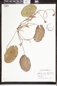 Brasenia schreberi J.F. Gmelin 453948[1329113]Harris, Fred 961411996-07-01 United States, Minnesota, Wright, Wright County ... Cedar Lake ... approx. 50 fet offshore on south side of north unit of lake ... T121N R25W NE1/4 of NW1/4 of Sec 30. 121N 25W 30, 45.2597754 -93.8800126 |
MIN:Plants |  Brasenia schreberi J.F. Gmelin 509346[1329115]Myhre, K. 64491996-07-30 United States, Minnesota, Crow Wing, Crow Wing County ... Located 18 miles northeast of the town of Brainerd ... south bay of Shirt Lake ... T 46N R 28W SW1/4 of NE1/4 of Sec 35. 046N 28W 35, 46.4244682 -93.8416903 |
MIN:Plants | Brasenia schreberi J.F. Gmelin 507949[]Gerdes, Lynden; et al. 31221998-08-10 United States, Minnesota, Cook, Superior National Forest. T65N R02W S19NESE. Cook County; Superior National Forest. Beaver flooded wetland just back of the bay at the far southeast end of Gunflint Lake.. 065N 02W 19, 48.0987095 -90.6304157 |
MIN:Plants | Brasenia schreberi J.F. Gmelin 913560[]Smith, Welby 245681994-07-09 United States, Minnesota, Benton, Bibles Wildlife Management Area. Benton County... In Bibles State Wildlife Management Area; about 5 miles north of Santiago...T36N R28W SW1/4 of NW1/4 of Sec 15. 036N 28W 15, 45.6133333 -93.82 |
MIN:Plants | Brasenia schreberi J.F. Gmelin 907065[]Lee, Michael MDL45542007-09-07 United States, Minnesota, Wadena, One mile northwest of the Knob Hill- Crow Wing River campground, 3.5 miles south-southwest of Oylen. UTM: 5155300N 358852E. SW1/4 of NW1/4 and SE1/4 of NW1/4 of section;Lyons State Forest;135N;33W;03, 46.5364539 -94.8407431 |
MIN:Plants | Brasenia schreberi J.F. Gmelin 898969[]Smith, Welby 257221995-07-09 United States, Minnesota, Isanti, Crooked Road Wildlife Management Area. Isanti County...At Mud Lake, in Crooked road State Wildlife Management Area...southern margin of lake...T35N R25W NW1/4 of NE!/4 of sec 33. 035N 25W 33, 45.485 -93.4575 |
MIN:Plants | Brasenia schreberi J.F. Gmelin 907066[]Lee, Michael MDL45412007-08-31 United States, Minnesota, Wadena, Huntersville State Forest / Wildlife Management Area. Wadena County ... Huntersville State Forest ... Southwest of Duck Lake, just north of the Shell River, 2.5 miles northwest of Huntersville ... T138N R34W SW1/4 of NW1/4 Sec. 1 ... UTM: 5184637N 352676E. 138N 34W 1, 46.7975921 -94.9222262 |
MIN:Plants | Brasenia schreberi J.F. Gmelin 110270[]Lugger, O. s.n.1891-00-00 United States, Minnesota, Ramsey, Lake Johanna;;030N;23W;, 45.0800317 -93.1669268 |
MIN:Plants | Brasenia schreberi J.F. Gmelin 110271[]Taylor, B. T15001892-07-00 United States, Minnesota, Chisago, Chisago Lake;;N;;, 45.360426 -92.87121 |
MIN:Plants | Brasenia schreberi J.F. Gmelin 110272[]Sheldon, Edmund S31521892-07-00 United States, Minnesota, Kanabec, Mora;;039N;24W;, 45.8606833 -93.3275287 |
MIN:Plants | Brasenia schreberi J.F. Gmelin 110273[]Sheldon, Edmund S7041891-07-00 United States, Minnesota, Ramsey, White Bear;;030N;22W;, 45.0798944 -93.0455023 |
MIN:Plants | Brasenia schreberi J.F. Gmelin 110274[]Ballard, C. B8541891-08-00 United States, Minnesota, Carver, Page Lake;;N;;, 44.820759 -93.802586 |
MIN:Plants | Brasenia schreberi J.F. Gmelin 110275[]Aiton, G. s.n.1890-08-00 United States, Minnesota, Hennepin, Lake Christmas, Excelsior;;;;, 44.903296 -93.566346 |
MIN:Plants | Brasenia schreberi J.F. Gmelin 110276[]Ballard, C. B8581891-08-00 United States, Minnesota, Carver, Waconia;;116N;25W;, 44.8475998 -93.8277531 |
MIN:Plants | Brasenia schreberi J.F. Gmelin 110277[]Holtz, Fred s.n.1891-00-00 United States, Minnesota, Hennepin, [no further data];;;;, 45 -93.47 |
MIN:Plants | Brasenia schreberi J.F. Gmelin 110278[]Sheldon, Edmund S4921891-06-00 United States, Minnesota, Le Sueur, Jefferson Lake, Le Sueur Co.;;109N;24W;, 44.2394984 -93.7071423 |
MIN:Plants | Brasenia schreberi J.F. Gmelin 110279[]Herrick, C. s.n.1878-07-13 United States, Minnesota, Hennepin, Minneapolis;;;;, 44.979965 -93.263836 |
MIN:Plants | Brasenia schreberi J.F. Gmelin 110280[]Sandberg, John s.n.1890-08-00 United States, Minnesota, Hennepin, [no further data];;;;, 45 -93.47 |
MIN:Plants | Brasenia schreberi J.F. Gmelin 276034[]Grant, Martin 33501929-09-14 United States, Minnesota, Clearwater, Itasca Park, Green Lake, SW-NW-13, T143, R36.;Itasca State Park;143N;36W;13, 47.2032572 -95.1801958 |
MIN:Plants | Brasenia schreberi J.F. Gmelin 276758[]Huff, N. 1881914-07-25 United States, Minnesota, Lake, Clear Lake, Lake Co.;Boundary Waters Canoe Area Wilderness / Superior National Forest;063N;10W;32, 47.8985588 -91.629703 |
MIN:Plants | Brasenia schreberi J.F. Gmelin 276795[]Huff, N. 1881914-07-25 United States, Minnesota, Lake, Clear Lake;;N;;, 47.902187 -91.631985 |
MIN:Plants | Brasenia schreberi J.F. Gmelin 277602[]Hotchkiss, N.; et al. 2811930-07-08 United States, Minnesota, Hennepin, N arm, Lake Minnetonka;;;;, 44.914963 -93.641348 |
MIN:Plants | Brasenia schreberi J.F. Gmelin 281359[]Roberts, Thomas s.n.1878-07-08 United States, Minnesota, Hennepin, Minneapolis;;;;, 44.979965 -93.263836 |
MIN:Plants | Brasenia schreberi J.F. Gmelin 306519[]Oosting, H. 281581928-08-04 United States, Minnesota, Ramsey, Snail Lake, N of St. Paul;Snail Lake Vadnais Lake County Park;030N;23W;, 45.0800317 -93.1669268 |
MIN:Plants | Brasenia schreberi J.F. Gmelin 306549[]Breckenridge, Walter 30811930-09-07 United States, Minnesota, Lake, Lake County...Silver Island Lake [no known lake by this name];;;;, 47.733268 -91.135248 |
MIN:Plants | Brasenia schreberi J.F. Gmelin 307084[]Moyle, J. 26131935-09-26 United States, Minnesota, Saint Louis, Trout Lake, Kabetogama Pen.;;N;;, 47.96483 -92.317289 |
MIN:Plants | Brasenia schreberi J.F. Gmelin 332618[]Grant, Martin 67461935-09-03 United States, Minnesota, Clearwater, Itasca Park, Squaw Lake, SW-SW-5, T143, R36.;Itasca State Park;143N;36W;5, 47.2314256 -95.2657843 |
MIN:Plants | Brasenia schreberi J.F. Gmelin 336476[]Moyle, J. 2261936-08-11 United States, Minnesota, Itasca, North Star Lake, T59, R26;Chippewa National Forest;059N;26W;, 47.5878711 -93.6411461 |
MIN:Plants |  Brasenia schreberi J.F. Gmelin 336516[]Moyle, J. 2351936-08-11 United States, Minnesota, Itasca, North Star Lake, T59, R26;Chippewa National Forest;059N;26W;, 47.5878711 -93.6411461 |
MIN:Plants | Brasenia schreberi J.F. Gmelin 337875[]Moyle, J. 2271936-08-11 United States, Minnesota, Itasca, North Star Lake;;N;;, 47.555117 -93.663784 |
MIN:Plants | Brasenia schreberi J.F. Gmelin 372395[]Lakela, Olga 44671941-06-29 United States, Minnesota, Saint Louis, Normanna Road, ca 14 mi N of Duluth;;N;;, 46.985947 -92.106579 |
MIN:Plants | Brasenia schreberi J.F. Gmelin 393432[]Lakela, Olga 70521947-07-29 United States, Minnesota, Saint Louis, small lake near Skibo;;N;;, 47.485479 -91.994337 |
MIN:Plants | Brasenia schreberi J.F. Gmelin 419537[]Lakela, Olga 115711950-08-21 United States, Minnesota, Saint Louis, Bay, Crooked Lake near Curtain Falls, St. Louis Co.;Boundary Waters Canoe Area Wilderness / Superior National Forest;067N;17W;, 48.2801546 -92.5208572 |
MIN:Plants | Brasenia schreberi J.F. Gmelin 421565[]Ahlgren, Clifford 7421950-07-05 United States, Minnesota, Lake, Quetico-Superior Wilderness Research Center...Lake Co, Basswood Lake, Ely, S9, T64N, R10W. Lake Co.;Boundary Waters Canoe Area Wilderness / Superior National Forest;064N;10W;09, 48.0316509 -91.6188616 |
MIN:Plants | Brasenia schreberi J.F. Gmelin 439362[]Smith, Welby 143171988-06-24 United States, Minnesota, Kanabec, Kanabek [sic] Co. At the NW end of Pomroy Lake, about 6 mi N of Quamba; NE1/4 SW1/4 sec.24, T41N R23W;;041N;23W;24, 46.0172207 -93.1913755 |
MIN:Plants | Brasenia schreberi J.F. Gmelin 440903[]Smith, Welby 138761987-08-16 United States, Minnesota, Lake, Lake County...In the BWCAW, Superior National Forest...Kawishiwi River...NE1/4 SE1/4 section 8, T62N R6W;Boundary Waters Canoe Area Wilderness / Superior National Forest;062N;06W;08, 47.868402 -91.1186253 |
MIN:Plants | Brasenia schreberi J.F. Gmelin 441752[]Lee, Michael MDL15461996-09-06 United States, Minnesota, Mille Lacs, Mille Lacs Kathio State Park. Mille Lacs Co.; Mille Lacs Kathio State Park; Black Bass Lake 4 1/2 miles WNW of Onamia; T42N R27W SE1/4 Sec. 11, SW1/4 Mille Lacs Co.; Mille Lacs Kathio State Park; Black Bass Lake 4 1/2 miles WNW of Onamia; T42N R27W SE1/4 Sec. 11, SW1/4 Sec. 12, NW1/4 Sec. 13, NE1/4 Sec. 14. 042N 27W , 46.113345 -93.7470847 |
MIN:Plants | Brasenia schreberi J.F. Gmelin 443298[]Lakela, Olga 134721951-07-20 United States, Minnesota, Saint Louis, Sturgeon Lake bog, 20 mi N of Hibbing;;N;;, 47.680485 -93.048239 |
MIN:Plants | Brasenia schreberi J.F. Gmelin 443721[]Myhre, K. 42761993-07-25 United States, Minnesota, Pine, Pine Co.; Located along the northeast shore of Pickerel Lake; T 45N R 17W SW1/4 of SE1/4 of Sec 1;Nemadji State Forest;045N;17W;1, 46.4104162 -92.4355809 |
MIN:Plants | Brasenia schreberi J.F. Gmelin 457086[]Smith, Welby 189011991-06-21 United States, Minnesota, Aitkin, Hill River State Forest. Aitkin County ... along the north side of Washburn Lake, about 6 miles east of Hill City ... T52N R25W NW1/4 of SW1/4 of Sec 24. 052N 25W 24, 46.980278 -93.4599991 |
MIN:Plants |  Brasenia schreberi J.F. Gmelin 475392[1329112]Myhre, K. 42761993-07-25 United States, Minnesota, Pine, Pine Co.; Located along the northeast shore of Pickerel Lake; T 45N R 17W SW1/4 of SE1/4 of Sec 1;Nemadji State Forest;045N;17W;1, 46.4104162 -92.4355809 |
MIN:Plants | Brasenia schreberi J.F. Gmelin 492794[]Lakela, Olga 162401953-07-18 United States, Minnesota, Saint Louis, St. Louis Co. Bay of Vermilion Lake at Treasure Island area;;;;, 47.910471 -92.589612 |
MIN:Plants | Brasenia schreberi J.F. Gmelin 492838[]Lakela, Olga 171311953-09-05 United States, Minnesota, Saint Louis, Trout Lake, N side, N of Vermilion Lake;;N;;, 47.891581 -92.366824 |
MIN:Plants | 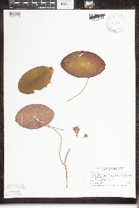 Brasenia schreberi J.F. Gmelin 514287[1329116]Smith, Welby 211681992-07-31 United States, Minnesota, Le Sueur, Le Sueur County ... at the S end of Fish Lake, about 2 mi N of Elysian ... T109N R24W SE1/4 of SE1/4 of sec 23;;109N;24W;23, 44.2272224 -93.6699982 |
MIN:Plants | Brasenia schreberi J.F. Gmelin 514380[]Smith, Welby 180011990-08-16 United States, Minnesota, Cook, Boundary Waters Canoe Area Wilderness / Superior National Forest. Cook County ... in Long Island River in the Boundary Waters Canoe Area Wilderness, Superior National Forest ... T64N R4W SW1/4 of SW1/4 of Sec 24. 064N 04W 24, 48.0086098 -90.7877808 |
MIN:Plants | Brasenia schreberi J.F. Gmelin 514816[]Smith, Welby 190481991-06-30 United States, Minnesota, Aitkin, Aitkin County ... about 3 mi northwest of Glen ... T46N R26W NE1/4 of SW1/4 of sec 24;;046N;26W;24, 46.4494438 -93.569725 |
MIN:Plants | 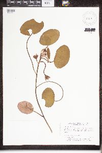 Brasenia schreberi J.F. Gmelin 515119[1329114]Myhre, K. 5163A1994-07-05 United States, Minnesota, Itasca, Itasca Co.; Located 2.7 miles southwest of the town of Bigfork; T 60N R 26W SW1/4 of SW1/4 of Sec 5;Chippewa National Forest;060N;26W;5, 47.7135664 -93.6732517 |
MIN:Plants | Brasenia schreberi J.F. Gmelin 515826[]Scott, P. 7341993-08-20 United States, Minnesota, Cook, Cook Co. Pewee Bog, near intersection of Gunflint Trail & CR65. T64N R1W Sec.8.;Superior National Forest;064N;01W;8, 48.0421258 -90.4806461 |
MIN:Plants | Brasenia schreberi J.F. Gmelin 519154[]Scott, P. 7771994-08-26 United States, Minnesota, Cook, Cook Co. Horseshoe Lake, B.W.C.A.W. T64N R1W Sec.19;Boundary Waters Canoe Area Wilderness / Superior National Forest;064N;01W;19, 48.0122123 -90.5012505 |
MIN:Plants | Brasenia schreberi J.F. Gmelin 525277[]Myhre, K. 33391992-09-22 United States, Minnesota, Cass, Cass Co.; Located on the southeast shore of Pine Lake; T 141n R 29W NE1/4 of NW1/4 of Sec 20;Chippewa National Forest / Leech Lake Indian Reservation;141N;29W;20, 47.0153492 -94.3751096 |
MIN:Plants | Brasenia schreberi J.F. Gmelin 527954[]Fallstad, R.; et al. s.n.1953-07-26 United States, Minnesota, Otter Tail, Otter Tail Co. Orwell Reservoir in Otter Tail River, 1/8 mi S of Dayton Hollow Dam, T132, R43, S20;;132N;43W;20, 46.2318758 -96.1136247 |
MIN:Plants | Brasenia schreberi J.F. Gmelin 543419[]Lakela, Olga 219811957-08-14 United States, Minnesota, Lake, in Greenwood Lake, Hwy #2, N of Two Harbors;;N;;, 47.518701 -91.63254 |
MIN:Plants | Brasenia schreberi J.F. Gmelin 568877[]Moore, John 252281960-08-12 United States, Minnesota, Anoka, Fish Lake, along S shore;Cedar Creek National History Area;034N;23W;, 45.4280632 -93.2039968 |
MIN:Plants | Brasenia schreberi J.F. Gmelin 594150[]Thorne, Robert 311521962-07-17 United States, Minnesota, Clearwater, NW bay of Squaw Lake, Itasca State Park;Itasca State Park;143N;36W;, 47.19557 -95.2332161 |
MIN:Plants | Brasenia schreberi J.F. Gmelin 607667[]Westkaemper, Remberta s.n.1966-08-00 United States, Minnesota, Stearns, Stearns Co. Lake Sagatogan, St. John's [Univ.], Collegeville;;124N;30W;, 45.5433118 -94.4446188 |
MIN:Plants | Brasenia schreberi J.F. Gmelin 616417[]Moore, John; et al. 4111969-08-07 United States, Minnesota, Crow Wing, Crow Wing Natural History Area, Crow Wing County...Along the E shore of Chandler Lake, SW1/4 S22, Garrison Twp.;Crow Wing Natural Area;044N;28W;22, 46.2789902 -93.8633363 |
MIN:Plants | Brasenia schreberi J.F. Gmelin 619241[]Westkaemper, Remberta s.n.1969-09-00 United States, Minnesota, Stearns, Stearns Co. Island Lake, Collegeville;;124N;30W;, 45.5433118 -94.4446188 |
MIN:Plants | Brasenia schreberi J.F. Gmelin 687124[]Wheeler, Gerald; Glaser, Paul 15511977-06-04 United States, Minnesota, Itasca, Coll. site no 38. SW1/4 NW1/4 S29, T57N, R25W; ca 10 mi N of Grand Rapids;;057N;25W;29, 47.3929387 -93.5463434 |
MIN:Plants | Brasenia schreberi J.F. Gmelin 746608[]Smith, Welby 58361981-09-20 United States, Minnesota, Wright, Wright Co. North Lake, about 5 mi SW of Monticello. SW1/4 NW1/4 S20, T121N, R25W.;;121N;25W;20, 45.2738453 -93.8581168 |
MIN:Plants | Brasenia schreberi J.F. Gmelin 746612[]Smith, Welby 57591981-09-13 United States, Minnesota, Wright, Wright Co. Cedar Lake, about 5 mi SW of Monticello. NW1/4 NE1/4 S30, T121N, R25W;;121N;25W;30, 45.2597754 -93.8800126 |
MIN:Plants | Brasenia schreberi J.F. Gmelin 777708[]Boe, J. 21071985-08-12 United States, Minnesota, Lake of the Woods, Brown's Lake State Waterfowl Refuge. Near E entrance to "loop". T159N, R35W, NE1/4 SE1/4 S3.;;159N;35W;3, 48.6197084 -95.1374532 |
MIN:Plants | Brasenia schreberi J.F. Gmelin 780473[]Ownbey, Gerald 69211984-07-07 United States, Minnesota, Clearwater, T144N, R38W, on line between S 5 & 6. S side of Minn Rte 200, 1.2 mi SE of its jnc with Co. Rte 7 in the town of Roy Lak T144N, R38W, on line between S 5 & 6. S side of Minn Rte 200, 1.2 mi SE of its jnc with Co. Rte 7 in the town of Roy Lake.. 144N 38W , 47.2818356 -95.4877534 |
MIN:Plants | Brasenia schreberi J.F. Gmelin 789770[]Smith, Welby 109521985-07-31 United States, Minnesota, Beltrami, S end of Grass lake, ca 2 mi W of Bemidji. SW1/4 NW1/4 S1, T146N, R34W;;146N;34W;1, 47.4914131 -94.9379179 |
MIN:Plants | Brasenia schreberi J.F. Gmelin 796495[]Cholewa, A.; Engels, A. 15251988-08-06 United States, Minnesota, Aitkin, Aitkin Co. Ca. 4 mi S of Palisade, NW shore of Jenkins Lake, T48N, R25W, S10 SE1/4 of SE1/4.;;048N;25W;10, 46.6598714 -93.4953267 |
MIN:Plants | Brasenia schreberi J.F. Gmelin 796554[]Sather, Nancy 87-0771987-09-04 United States, Minnesota, Itasca, Chippewa National Forest. Itasca County...Clustered Bur Reed Bog, T57N, R25W, S18 SW1/4. NE of Pughole Lake and W of USFS 2144. 14 mi N of Grand Rapids...On N side of wetland, 15m W of overgrown logging trail. 057N 25W 18, 47.4158325 -93.5661087 |
MIN:Plants | Brasenia schreberi J.F. Gmelin 817133[]Delaney, B. 892971989-08-25 United States, Minnesota, Isanti, 2 mi NE of the crossroads known as Springvale; at the Springvale Campground. NW1/4 NE1/4 S1, T36N, R24W;;036N;24W;1, 45.6376054 -93.2759541 |
MIN:Plants | Brasenia schreberi J.F. Gmelin 829469[]Myhre, K. 22621992-06-17 United States, Minnesota, Cass, Cass Co. Located 2 mi N of the public access to Town Line Lake; T142N R28W SW1/4 of SE1/4 of Sec 22;Chippewa National Forest / Leech Lake Indian Reservation;142N;28W;22, 47.1044479 -94.2141247 |
MIN:Plants | Brasenia schreberi J.F. Gmelin 830990[]Cholewa, A. 20761992-08-22 United States, Minnesota, Aitkin, Aitkin Co. Savanna State Forest, Camp Lakes, E (minor) lake, ca. 2 mi N of hwy.6 on co.rd.75. T49N R23W Sec.13 NW1/4.;Savanna State Forest;049N;23W;13, 46.7311045 -93.2021449 |
MIN:Plants | 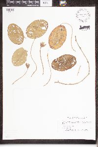 Brasenia schreberi J.F. Gmelin 833082[1329117]Myhre, K. 28641992-07-27 United States, Minnesota, Cass, Cass Co. Located on the SE shore of Moose lake; T136N R31W SW1/4 of NW1/4 of Sec.15;;126N;31W;15, 46.594311 -94.572517 |
MIN:Plants | Brasenia schreberi J.F. Gmelin 833654[]Smith, Welby 142681988-06-20 United States, Minnesota, Washington, Washington County ... At the S end of Oneka Lake, about 2 mi NE Hugo ... SW1/4 SE1/4 sec 9, T31N R21W;;031N;21W;9, 45.1833344 -92.9694443 |
MIN:Plants | Brasenia schreberi J.F. Gmelin 834412[]Smith, Welby 200071991-08-14 United States, Minnesota, Cook, Boundary Waters Canoe Area Wilderness / Superior National Forest. Cook County...In the Boundary Waters Canoe Area Wilderness, Superior National Forest...S end of Bug Lake... T63N R5W SW1/4 of SW1/4 of Sec 8. 063N 05W 8, 47.9463882 -91.0022202 |
MIN:Plants | Brasenia schreberi J.F. Gmelin 835504[]Monson, Paul 44971961-06-30 United States, Minnesota, Becker, Becker Co. R-36 T-142 S-5,6,7,8. Two Island Lake [Twin Island Lake];Itasca State Park;142N;36W;, 47.1088021 -95.2335371 |
MIN:Plants | Brasenia schreberi J.F. Gmelin 836294[]Cholewa, A. 23841995-07-28 United States, Minnesota, Aitkin, Aitkin Co. Savanna Portage State Park, about 17 mi NE of McGregor, SW end of Wolf Lake, T50N R22W S6 SE1/4 of NE1/4.;Savanna Portage State Park;050N;22W;6, 46.845996 -93.1774497 |
MIN:Plants | Brasenia schreberi J.F. Gmelin 841267[]Smith, Welby 145181988-07-12 United States, Minnesota, Washington, Washington County ... At the N end of Big Marine Lake, about 5 mi NW of Marine on St. Croix ... NW1/4 SE1/4 sec.20 T32N R20W. 032N 20W 20, 45.2425003 -92.8611145 |
MIN:Plants | Brasenia schreberi J.F. Gmelin 842515[]Myhre, K. 61671995-08-27 United States, Minnesota, Aitkin, Aitkin Co. Located 3 mi SE of the town of Aitkin; NW shores of Little Hansen Lake; T47N R26W NW1/4 of NW1/4 of Sec 33.;;047N;26W;33, 46.5119818 -93.6328613 |
MIN:Plants | Brasenia schreberi J.F. Gmelin 842838[]Myhre, K. 60401995-08-09 United States, Minnesota, Aitkin, Aitkin Co. Located 3 mi SE of the town of Aitkin. Plants occur along the SE bays of Nord Lake; T46N R26W NE1/4 of NE1/4 Aitkin Co. Located 3 mi SE of the town of Aitkin. Plants occur along the SE bays of Nord Lake; T46N R26W NE1/4 of NE1/4 of Sec 8.. 046N 26W 8, 46.4823454 -93.6538782 |
MIN:Plants | Brasenia schreberi J.F. Gmelin 842845[]Myhre, K. 59111995-07-22 United States, Minnesota, Aitkin, Aitkin County...Located 5 mi SE of the town of McGregor; NW shore of Sheriff Lake; T47N R23W NW1/4 of SW1/4 of sec 1.;;047N;23W;01, 46.5858354 -93.1897568 |
MIN:Plants | Brasenia schreberi J.F. Gmelin 920270[]Smith, Welby 182891990-08-31 United States, Minnesota, Morrison, Camp Ripley Military Reservation. Camp Ripley Military Reservation. Morrison County...On the E side of Luzon Road...Goose Pond...UTM: 389600E 5108500N T 131N R 30W NW1/4 of NW1/4 of Sec 35. 131N 30W 35, 46.1230556 -94.4288889 |
MIN:Plants | Brasenia schreberi J.F. Gmelin 906355[]Lee, Michael MDL37222004-07-21 United States, Minnesota, Becker, White Earth Indian Reservation. Becker County...On the shores of Mary Yellowhead Lake, 7-1/2 miles east-northeast of Richwood...northeast end of lake...T141N R40W NE1/4 of NE1/4 Sec. 24. 141N 40W 24, 47.0127496 -95.6899773 |
MIN:Plants | Brasenia schreberi J.F. Gmelin 904574[]Smith, Welby 262981996-08-01 United States, Minnesota, Wright, Wright County...Nixon Lake, about 7 miles north-northeast of Annandale...T 122N R 27W SE1/4 of SE1/4 of sec 22;;122N;27W;22, 45.3569444 -94.0577778 |
MIN:Plants | Brasenia schreberi J.F. Gmelin 439078[]Proulx, N.; et al. 82-1302005-07-07 United States, Minnesota, Washington, Washington County, Long Lake;;;;, 45.034718 -92.959876 |
MIN:Plants | Brasenia schreberi J.F. Gmelin 110269[]Wheeler, William 7411900-08-00 United States, Michigan, Keweenaw, Tobin Harbor, Isle Royale;Isle Royale National Park |
MIN:Plants | Brasenia schreberi J.F. Gmelin 910557[]Loso, Stephanie; et al. 14602008-07-31 United States, Minnesota, Cass, County: Cass. Lake ID: 11030400. Lake: Sylvan...T133, R30W, Sec 11. West bay of lower Sylvan lake, near DNR site 1;;133N;30W;11, 46.3477094 -94.4220373 |
MIN:Plants | Brasenia schreberi J.F. Gmelin 906344[]Lee, Michael MDL37162004-07-20 United States, Minnesota, Todd, Todd County...Pine Island Lake, 6-1/2 miles west-southwest of Cushing, and 8 miles east-northeast of Browerville... west end of lake...T131N R32W SW1/4 of NE1/4 Sec. 33, SE1/4 of NW1/4 Sec. 34. 131N 32W 0, 46.11486 -94.720817 |
MIN:Plants | Brasenia schreberi J.F. Gmelin 479213[]Kaul, R. 25631982-07-26 United States, Minnesota, Clearwater, Clearwater Co, Squaw Lake, northwest corner;Itasca State Park;143N;36W;, 47.197458 -95.201964 |
MIN:Plants | 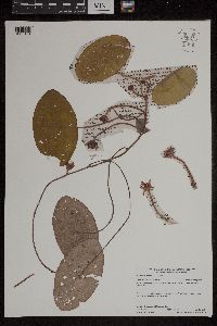 Brasenia schreberi J.F. Gmelin 958927[1305164]Lynden B. Gerdes 71442014-07-30 United States, Minnesota, Saint Louis, Superior National Forest, Nina Moose Lake, BWCAW. Near western lakeshore., 48.165 -92.08527778 |
MIN:Plants |  Brasenia schreberi J.F. Gmelin 976661[1402252]Timothy J. S. Whitfeld 29062021-07-17 United States, Minnesota, St. Louis, Voyageurs National Park, 0.4 miles west of the northern mouth of Browns Bay, Sand Point Lake, 48.383911 -92.55043, 360m |
MIN:Plants |  Brasenia schreberi J.F. Gmelin 968375[1368952]Millaway, Courtney L. CLM2112018-07-10 United States, Minnesota, Wright, 6 miles southwest of Annandale., 45.22394 -94.23427 |
MIN:Plants |  Brasenia schreberi J.F. Gmelin 975819[1404803]Perleberg, Donna J. DJP2019.0812-052019-08-12 United States, Minnesota, Morrison, unnamed Lake (), 46.00735 -94.30384 |
MIN:Plants |  Brasenia schreberi J.F. Gmelin 976757[1402366]Perleberg, Donna J. DJP2013.0820-072013-08-20 United States, Minnesota, Cook, Superior National Forest; Tait Lake (16038400) west shore, 47.81463 -90.68417 |
MIN:Plants | 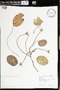 Brasenia schreberi J.F. Gmelin 976756[1402365]Perleberg, Donna J. DJP2018.0822-202018-08-22 United States, Minnesota, St. Louis, Kabetogama State Forest; Superior National Forest; Elephant Lake (69081000) north shore, 48.20456 -92.756796 |
1
Page 1, records 1-92 of 92
Google Map
Google Maps is a web mapping service provided by Google that features a map that users can pan (by dragging the mouse) and zoom (by using the mouse wheel). Collection points are displayed as colored markers that when clicked on, displays the full information for that collection. When multiple species are queried (separated by semi-colons), different colored markers denote each individual species.