University of Minnesota
http://www.umn.edu/
612-625-5000
http://www.umn.edu/
612-625-5000
Minnesota Biodiversity Atlas
Bell Museum
Dataset: MIN-Plants
Taxa: Dipsacaceae
Search Criteria: excluding cultivated/captive occurrences
1
Page 1, records 1-92 of 92
Bell Museum plants | |
 MIN:Plants | Knautia arvensis (L.) J.M. Coulter 277050[]Rosendahl, C. 50031926-07-02 United States, Minnesota, Clearwater, 4-5 mi NW of Itasca Park.;;N;;, 47.331053 -95.306595 |
MIN:Plants | Knautia arvensis (L.) J.M. Coulter 356148[]Stevens, O. s.n.1937-07-10 United States, Minnesota, Clay, Moorhead;;N;;, 46.873852 -96.767581 |
MIN:Plants | Knautia arvensis (L.) J.M. Coulter 515841[]Myhre, K. 24781992-06-30 United States, Minnesota, Cass, Cass Co.; Located one quarter mile southwest of Boxell Lake; T 141N R 28W SW1/4 of SW1/4 of Sec 27;Chippewa National Forest / Leech Lake Indian Reservation;141N;28W;27, 47.00051 -94.215535 |
MIN:Plants | Knautia arvensis (L.) J.M. Coulter 743820[]Ownbey, Gerald 68371982-07-11 United States, Minnesota, Clearwater, along co. rt. 107, T144N R36W Sec.20 E1/2, Sec.21 W1/2.;;144N;36W;, 47.275171 -95.264844 |
MIN:Plants | Knautia arvensis (L.) J.M. Coulter 830101[]Myhre, K. 24771992-06-30 United States, Minnesota, Cass, Cass Co. Located one quarter mi SW of Boxell Lake; T141N R28W SW1/4 of SW1/4 of Sec 27;Chippewa National Forest / Leech Lake Indian Reservation;141N;28W;27, 47.00051 -94.215535 |
MIN:Plants | 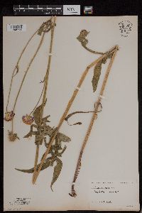 Knautia arvensis (L.) J.M. Coulter 954166[1295711]Stork, H. E. s.n. United States, New York, Tompkins |
MIN:Plants | 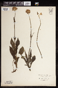 Knautia arvensis (L.) J.M. Coulter 954167[1346943] Switzerland |
MIN:Plants | 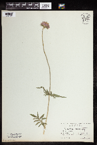 Knautia arvensis (L.) J.M. Coulter 954168[1346944] Austria |
MIN:Plants | 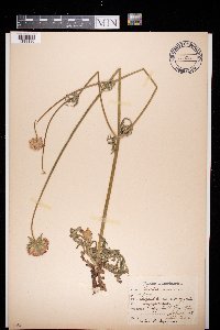 Knautia arvensis (L.) J.M. Coulter 972580[1398130]Julius Persson s.n.1928-07-11 Sweden, Jonkoping, Skeppshult |
MIN:Plants |  Knautia arvensis (L.) J.M. Coulter 972732[1398285]Janssens, J. 1871974-07-18 France, Gueberschwihr, Vosges, 400m |
MIN:Plants |  951422[1290498]Justen, Emilie s.n.2016-09-27 United States, Minnesota, Nobles, [no further data], 43.7032 -95.6504 |
MIN:Plants |  951051[1290516]Heuring, Erik s.n.2016-08-20 United States, Minnesota, Wright, [no further data], 45.2232 -93.8349 |
MIN:Plants |  954165[1295712]Wible, Paul G. s.n.1928-08-02 United States, Indiana, Lawrence |
MIN:Plants | 552224[]Lakela, Olga 226631958-05-26 United States, Minnesota, Saint Louis, border of Park Hill Cemetery, near waste dump, Duluth;;N;;, 46.842639 -92.068425 |
MIN:Plants | 552231[]Lakela, Olga 226691958-08-01 United States, Minnesota, Saint Louis, Park Hill Cemetery near waste dump, Duluth;;N;;, 46.842639 -92.068425 |
MIN:Plants | 438447[]Cochran, Philip s.n.2001-09-21 United States, Minnesota, Winona, Winona Co. ... north side of Farmers Community Park (T106N,R8W,S8).;;106N;08W;08, 43.998392 -91.809804 |
MIN:Plants | 540914[]Cochran, Philip s.n.2005-12-29 United States, Minnesota, Winona, State Highway 76 south of interstate 90, Winona County;;;;, 43.880536 -91.608841 |
MIN:Plants | 940701[]Moriarity, J. 101997-08-01 United States, Minnesota, Ramsey, In Roseville, corner of Lexington Ave. and Cty Rd C2. NE1/4 SE1/4 of sec.;;029N;23W;03, 45.028278 -93.156862 |
MIN:Plants | 938994[]Chandler, Monika 20249682011-06-28 United States, Minnesota, Winona, Township road 14, 43.8616 -91.6427 |
MIN:Plants | Cephalaria gigantea (Ledeb.) Bobr. 494371[]Huff, N. 1941-07-31 United States, Minnesota, Hennepin, Glenwood Park. Minneapolis;Theodore Wirth County Park;029N;24W;19, 44.984416 -93.339044 |
MIN:Plants | Dipsacus fullonum subsp. sylvestris (Hudson) Clapham 436681[]Cochran, Philip; Cochran, Joseph s.n.2006-08-06 United States, Minnesota, Winona, Winona Co, MN, along Pine Creek upstream from School Section Road crossing. (T105N, R9W, S25);;105N;09W;25, 43.8685564 -91.8492821 |
MIN:Plants | Dipsacus fullonum subsp. sylvestris (Hudson) Clapham 510384[]Bright, R. 77-221977-00-00 United States, Idaho, Franklin, [no further data] |
MIN:Plants |  Knautia sylvatica Duby 954169[1346945] Austria |
MIN:Plants | 294795[]Benner, F.; Benner, J. 3441928-09-15 United States, Wisconsin, Polk, 5 mi. N. St. Croix Falls on River Road;Saint Croix National Riverway;;;, 45.470949 -92.681073 |
MIN:Plants | 493571[]Smith, Welby 155181989-06-30 United States, Minnesota, Chisago, Chisago County ... Interstate State Park, about one mile south of Taylors Falls ... SW1/4 NW1/4 section 36, T34N R19W;Interstate State Park;034N;19W;36, 45.3952789 -92.6688919 |
MIN:Plants | 297546[]Benner, F.; Benner, J. 341928-07-08 United States, Wisconsin, Polk, 4 mi. N. St. Croix Falls on River Road;Saint Croix National Riverway;;;, 45.463011 -92.664013 |
MIN:Plants | 484749[]Kaul, R.; et al. 29591984-06-30 United States, Minnesota, Steele, Steele County...along Maple Creek at Mineral Springs.;;107N;20W;, 44.094946 -93.199044 |
MIN:Plants | 599207[]Tryon, R. 13491935-07-12 United States, Indiana, Porter, Dunes State Park, Porter Co.;Indiana Dunes National Lakeshore;;;, 41.663093 -87.032128 |
MIN:Plants | 264239[]Holzinger, John s.n.1901-07-00 United States, Minnesota, Winona, In the vic. of Winona.;;N;;, 44.049963 -91.639315 |
MIN:Plants | 274865[]Rosendahl, C. 57521928-09-19 United States, Minnesota, Dakota, lower end of ravine at Pine Bend. Dakota County.;;115N;18W;18, 44.7680435 -93.0243352 |
MIN:Plants | 278195[]Roberts, Thomas s.n.1884-07-13 United States, Minnesota, Ramsey, St. Paul;;;;, 44.955714 -93.09079 |
MIN:Plants | 366444[]Rosendahl, C.; et al. 72171939-06-23 United States, Minnesota, Winona, Just opposite the S end of Trumpealeau Mt, along hwy. 61, 3/4 mi below Indian Inscription Caves, 3 mi. below Lamoille.;;106N;05W;, 43.963328 -91.43962 |
MIN:Plants | 369951[]Moore, John; et al. 140801941-05-24 United States, Minnesota, Chisago, 1 1/2 mi. NE of Rush City.;;037N;21W;14, 45.694928 -92.929474 |
MIN:Plants | 370050[]Moore, John; et al. 140141941-05-24 United States, Minnesota, Pine, 1 mi SE of the bridge over Snake River. Pine Co.;;039N;21W;26, 45.8391391 -92.929089 |
MIN:Plants | 370858[]Moore, John; Moore, Marjorie 135511940-09-12 United States, Minnesota, Washington, along the St. Croix River, 2 mi S of Afton;;028N;20W;, 44.873782 -92.783537 |
MIN:Plants | 381401[]Moore, John; et al. 154151942-06-20 United States, Minnesota, Olmsted, 1 mi. N of Rochester, on hwy. 63. Olmsted Co.;;;;, 44.103214 -92.435367 |
MIN:Plants | 381466[]Moore, John; et al. 154591942-06-20 United States, Minnesota, Dodge, 1 mi E [W?] of Berne. Dodge Co.;;108N;17W;, 44.153161 -92.862109 |
MIN:Plants | 441895[]Moore, John; Huff, N. 181761945-08-15 United States, Minnesota, Rice, Above the falls, Nerstrand Woods.;Nerstrand Woods State Park;110N;19W;, 44.327064 -93.100886 |
MIN:Plants | 444727[]Moore, John; Huff, N. 193491946-10-05 United States, Minnesota, Rice, Rice County...Nerstrand Woods State Park.;Nerstrand Woods State Park;110N;19W;00, 44.3270643 -93.1008855 |
MIN:Plants | 445400[]Nation, R. 94-0891994-06-08 United States, Minnesota, Mower, Lake Louise State Park. Mower Co.; Tract #3A. T101N R14W NW1/4 of SW1/4 of sec. 21;Lake Louise State Park;101N;14W;21, 43.5365784 -92.5190432 |
MIN:Plants | 453454[]Smith, Welby 130841987-06-19 United States, Minnesota, Washington, Washington Co.; About 7 miles west of Marine on St. croix; NW1/4 NE1/4 section 2, T 31N R 21W;;031N;21W;2, 45.207222 -92.9238892 |
MIN:Plants | 453676[]Myhre, K. 44341993-08-10 United States, Minnesota, Pine, Pine Co.; Located one quarter mile north of Mallard Lake; T 41N R 16W SW1/4 of NW1/4 of Sec 16;Saint Croix State Forest;041N;16W;16, 46.0338383 -92.3731389 |
MIN:Plants | 459140[]Smith, Welby 130841987-06-19 United States, Minnesota, Washington, Washington Co.; about 7 mi W of Marine on St. Croix; NW1/4 NE1/4 sec.2, T31N R21W;;031N;21W;2, 45.207222 -92.9238892 |
MIN:Plants | 520230[]Smith, Welby 129621987-06-16 United States, Minnesota, Washington, Washington County...On the E side of Highway 4, about 1/2 mi NW of Marine on St. Croix...about 150 feet above the floodplain of the St. Croix River...SW1/4 NE1/4 sec.1, T31N R20W. 031N 20W 1, 45.2061111 -92.7797222 |
MIN:Plants | 570317[]Lawrence, Donald 1961-05-01 United States, Minnesota, Anoka, Carlos Avery Game Refuge, 2 mi. E of the Forest Nursery.;Carlos Avery Wildlife Management Area;N;;, 45.30949 -93.102078 |
MIN:Plants | 484827[]Lee, Michael MDL14281996-07-26 United States, Minnesota, Wabasha, Upper Mississippi National Wildlife Refuge. Wabasha Co.; Mississippi River floodplain 1 miles SSE of West Newton; between main channel and Halfmoon Lake; T109N R9W Wabasha Co.; Mississippi River floodplain 1 miles SSE of West Newton; between main channel and Halfmoon Lake; T109N R9W NE1/4 NW1/4 NE1/4 Sec. 16. 109N 09W 16, 44.243736 -91.899291 |
MIN:Plants | 570346[]Morley, T. 9631961-05-21 United States, Minnesota, Goodhue, On the W boundary, ca. 1/4 mi. S of the N boundary, where the flood plain meets a hill on the S side of the Little Canno On the W boundary, ca. 1/4 mi. S of the N boundary, where the flood plain meets a hill on the S side of the Little Cannon River.. 111N 17W 6, 44.4494049 -92.9049454 |
MIN:Plants | 572550[]Moore, John 253851961-06-06 United States, Minnesota, Houston, Reno.;;101N;04W;, 43.601082 -91.275134 |
MIN:Plants | 585453[]Moore, John 263071963-06-04 United States, Minnesota, Houston, 1 mi. N of Brownsville.;Dorer Memorial Hardwood State Forest;103N;04W;, 43.719291 -91.28226 |
MIN:Plants | 649418[]Kaul, R. 24181974-07-24 United States, Minnesota, Steele, At the W edge of Mineral Springs Park in Owatonna.;;N;;, 44.09663 -93.197154 |
MIN:Plants | 672769[]Wheeler, Gerald 8441976-07-21 United States, Minnesota, Winona, Winona Co. Approx. 4.8 mi. S of the John A. Latsch State Park on hwy. 61; thin woods bordering on the Mississippi River.;;N;;, 44.1619 -91.8222 |
MIN:Plants | 683073[]Morley, T. s.n.1977-07-17 United States, Minnesota, Fillmore, Fillmore Co.; T103N, R12W, E1/2 SE1/4 sec.17;Dorer Memorial Hardwood State Forest / Wykoff Balsam Fir Scientific Natural Area;103N;12W;17, 43.7248071 -92.2993454 |
MIN:Plants | 708414[]Ownbey, Gerald 64671979-09-13 United States, Minnesota, Washington, Washington County ... T 30N R 20W Sec.14 NWj1/4, 1.5-2.0 mi. northeast of Stillwater ... St. Croix River.;Saint Croix National Riverway;030N;20W;14, 45.090515 -92.777311 |
MIN:Plants | 717931[]Johnson, Gary s.n.1979-07-07 United States, Minnesota, Isanti, 3 mi. N of Cambridge to the W of hwy. 65.;;N;;, 45.61618 -93.224392 |
MIN:Plants | 717940[]Johnson, Gary s.n.1980-07-07 United States, Minnesota, Kanabec, Kanabec Co. 5 mi S of Mora, E of hwy. 65 ca. 1/4 mi.;;038N;24W;, 45.804508 -93.293835 |
MIN:Plants | 724717[]Smith, Welby 26731980-06-26 United States, Minnesota, Houston, Houston Co. Ca. 3/4 mi. N of New Albin, and 1/4 mi. W of hwy. 26.;Dorer Memorial Hardwood State Forest;101N;04W;35, 43.508062 -91.282871 |
MIN:Plants | 728136[]Eikum, B. 1361979-07-17 United States, Minnesota, Dakota, Hastings;Hastings Scientific Natural Area;115N;17W;, 44.73907 -92.86266 |
MIN:Plants | 729683[]Cutler, S. 1071980-07-01 United States, Minnesota, Pine, Pine Co. St. Croix Natural Area: 21 mi E of Hinckley. T41N R17W NW1/4 NW1/4 sec.32;Saint Croix State Park;041N;17W;32, 45.9906767 -92.5191695 |
MIN:Plants | 729933[]Phelps, V. 411980-07-01 United States, Minnesota, Pine, Pine Co. Kettle River Natural Area: 5.5 mi. E of Hinckley. NW1/4 SW1/4, Sec.23, T41N, R20W; along Kettle River.;Kettle River Scientific Natural Area / Sandstone National Wildlife Refuge;041N;20W;23, 46.0186087 -92.8357974 |
MIN:Plants | 730182[]Phelps, V. 731980-07-03 United States, Minnesota, Chisago, Goose Creek Natural Area: 5 mi. SE of Rush City. Path along St. Croix River.;Wild River State Park;036N;20W;7, 45.62207 -92.8927646 |
MIN:Plants | 730302[]Cutler, S. 981980-06-23 United States, Minnesota, Chisago, Goose Creek Natural Area: 5 mi. SE of Rush City.;Wild River State Park;036N;20W;7, 45.62207 -92.8927646 |
MIN:Plants | 737257[]Kachman, R. 3871980-08-13 United States, Minnesota, Freeborn, Next to railroad grade about 1/4 mi. W of the Bur Oak Esker Trail in Helmer Myre SP.;Myre Big Island State Park;N;;, 43.634283 -93.304741 |
MIN:Plants | 747227[]Galatowitsch, S. 5031982-07-16 United States, Minnesota, Goodhue, Grace Nature Preserve.;Grace Nature Preserve, The Nature Conservancy;109N;18W;8, 44.262012 -93.010544 |
MIN:Plants | 770808[]Smith, Welby 85461983-08-03 United States, Minnesota, Mower, Ca. 3 mi. NE of Lyle.;;101N;17W;29, 43.5215013 -92.8985294 |
MIN:Plants | 781262[]Smith, Welby 93191984-06-23 United States, Minnesota, Mower, Lake Louise State Park, ca. 1 mi. N-NW of LeRoy. On the banks of the Upper Iowa River.;Lake Louise State Park;101N;14W;28, 43.5220987 -92.5189584 |
MIN:Plants | 808515[]Morley, T. s.n.1989-06-17 United States, Minnesota, Sherburne, Sherburne Co.;;;;, 45.441062 -93.793821 |
MIN:Plants | 833469[]Juhnke, C. 2631991-08-26 United States, Minnesota, Fillmore, Forestville State Park. Fillmore Co. T102N R12W Sec.24 NW NE NW;Forestville State Park;102N;12W;24, 43.6234111 -92.2191515 |
MIN:Plants | 841723[]Smith, Welby 145701988-07-21 United States, Minnesota, Mower, Mower Co. Lake Louise State Park, about 1 mi N-NW of LeRoy. NW1/4 SE1/4 sec.21, T101N R14W; Upper Iowa River;Lake Louise State Park;101N;14W;21, 43.5365784 -92.5190432 |
MIN:Plants | 91319[]Butters, F.; et al. 34941921-06-21 United States, Minnesota, Wabasha, Lower Zumbro Valley, ca. 2 mi. W of Kellogg.;;;;, 44.30857 -92.036199 |
MIN:Plants | 91320[]Manning, Sara s.n.1884-06-28 United States, Minnesota, Wabasha, Lake City;;N;;, 44.449412 -92.266844 |
MIN:Plants | 91321[]Ainslie, G. 1068 United States, Minnesota, Olmsted, Near Rochester.;;N;;, 44.03052 -92.476566 |
MIN:Plants | 91322[]Manning, Sara s.n.1884-06-28 United States, Minnesota, Wabasha, Lake City;;N;;, 44.449412 -92.266844 |
MIN:Plants | 91323[]Ainslie, G. 913231904-07-20 United States, Minnesota, Olmsted, Rochester;;106N;14W;, 43.97834 -92.49834 |
MIN:Plants | 91324[]Ainslie, G. 913241902-09-01 United States, Minnesota, Olmsted, Rochester.;;106N;12W;00, 43.9775128 -92.2588347 |
MIN:Plants | 91325[]Wheeler, William 3641899-07-17 United States, Minnesota, Houston, Crooked Creek, Houston Co.;Dorer Memorial Hardwood State Forest;N;;, 43.605798 -91.306668 |
MIN:Plants | 91326[]Taylor, B. s.n.1892-08-00 United States, Minnesota, Chisago, Lindstrom;;N;;, 45.383139 -92.845245 |
MIN:Plants | 91327[]Wheeler, William 3221899-07-10 United States, Minnesota, Houston, Mayville;Dorer Memorial Hardwood State Forest;102N;05W;, 43.630682 -91.431985 |
MIN:Plants | 91328[]Sandberg, John s.n.1890-08-00 United States, Minnesota, Hennepin, Minnehaha Falls.;Minnehaha Falls Park;028N;23W;17, 44.9117958 -93.2034333 |
MIN:Plants | 91329[]Taylor, B. T15291892-08-00 United States, Minnesota, Chisago, Chisago Lake;;N;;, 45.360426 -92.87121 |
MIN:Plants | 91330[]Sandberg, John s.n.1890-07-00 United States, Minnesota, Hennepin, [no further data];;;;, 45 -93.47 |
MIN:Plants | 91331[]Sheldon, Edmund S28581892-07-00 United States, Minnesota, Kanabec, Mora;;039N;24W;, 45.876903 -93.293835 |
MIN:Plants | 484741[]Kaul, R.; et al. 29601984-06-30 United States, Minnesota, Steele, Steele County...along Maple Creek at Mineral Springs.;;107N;20W;, 44.094946 -93.199044 |
MIN:Plants | 493584[]Smith, Welby 155231989-06-30 United States, Minnesota, Chisago, Chisago County ... Interstate State Park, about one mile south of Taylors Falls ... SW1/4 NW!/4 section 36, T 34N R 19W;Interstate State Park;034N;19W;36, 45.3952789 -92.6688919 |
MIN:Plants | 484742[]Sutherland, David; et al. 31991972-06-24 United States, Minnesota, Steele, Steele Co.: Owatonna; Mineral Springs Park.;;107N;20W;, 44.09663 -93.197154 |
MIN:Plants | 459527[]Smith, Welby 155181989-06-30 United States, Minnesota, Chisago, Chisago County...Interstate State Park, about one mile south of Taylors Falls...SW1/4 NW1/4 section 36, T34N R19W;Interstate State Park;034N;19W;36, 45.3952789 -92.6688919 |
MIN:Plants | 490604[]Juhnke, C. 517 CMJ FRO1999-08-10 United States, Minnesota, Goodhue, Frontenac State Park. Goodhue County ... on the north side of Rattlesnake Bluff ... T112N R13W NE NW NE 5;Frontenac State Park;112N;13W;05, 44.535196 -92.399973 |
MIN:Plants | 914913[]Smith, Welby 252131994-08-19 United States, Minnesota, Pine, Banning State Park. Pine County...In Banning State Park, about 3 miles north-northwest of Sandstone...along the Kettle River...T43N R20W NW1/4 of SW1/4 of Sec 35. 043N 20W 35, 46.1625 -92.8402778 |
MIN:Plants | 297658[]Benner, F.; Benner, J. 3441928-09-15 United States, Wisconsin, Polk, 4 mi. N. St. Croix Falls on River Road;Saint Croix National Riverway;;;, 45.463011 -92.664013 |
MIN:Plants | 934763[]Whitfeld, T. J. S.; et al. 9432012-06-16 United States, Minnesota, Goodhue, State Forest 2.5 miles south west of Frontenac. UTM: 15T054831, 4925881;Dorer Memorial Hardwood State Forest;;;, 44.484626 -92.3923942 |
MIN:Plants |  974255[1396619]Smith, Welby R WRS364702019-08-17 United States, Minnesota, Dakota, Spring Lake Regional Park, about 10.4 km (6.5 miles) west of the Mississippi River Bridge in Hastings., 44.757208 -92.982797 |
MIN:Plants |  975913[1373466]Smith, Welby R WRS366252020-04-18 United States, Minnesota, Anoka, Lamprey Pass State Scientific and Natural Area; about 3.8 km (2.35 miles) W-SW of the approximate center of the town of Forest Lake., 45.26387 -93.02953 |
MIN:Plants |  Cephalaria leucantha (L.) Roem. & Schult. 972714[1398267]Verbelen, E. 2521974-07-25 France, Provence, Fontaine de Vaucluse, 300m |
1
Page 1, records 1-92 of 92
Google Map
Google Maps is a web mapping service provided by Google that features a map that users can pan (by dragging the mouse) and zoom (by using the mouse wheel). Collection points are displayed as colored markers that when clicked on, displays the full information for that collection. When multiple species are queried (separated by semi-colons), different colored markers denote each individual species.