University of Minnesota
http://www.umn.edu/
612-625-5000
http://www.umn.edu/
612-625-5000
Minnesota Biodiversity Atlas
Bell Museum
Dataset: MIN-Plants
Taxa: Lamiaceae
Search Criteria: excluding cultivated/captive occurrences
Bell Museum plants | |
 MIN:Plants |  961222[1334725] United States, South Dakota |
MIN:Plants |  956415[1296264]Kramer, Leona s.n.1927-00-00 United States, Minnesota, Mower |
MIN:Plants |  956414[1296265]Kramer, Leona s.n.1927-00-00 United States, Minnesota, Mower |
MIN:Plants |  Mentha NULL 943926[1282988]Nee, M. 616562014-09-25 United States, Wisconsin, Richland, 4 km. NE of Gotham, Moss Hollow Lake. T9N;R2E;NE1/4NE1/4 sect. 21, 43.2475 -90.255556, 247m |
MIN:Plants |  960021[1318378]Stork, H.E 1917-08-20 United States, New York, West Shore of Lake Cayuga |
MIN:Plants |  960037[1318362]Stork, H.E. 1917-08-10 United States, New York, W shore of S. Caynoe |
MIN:Plants |  956432[1296247]Stork, H. E. s.n.1925-00-00 United States, Minnesota, Itasca |
MIN:Plants |  184958[1302516]Wood, J Medley 18211891-04-22 South Africa, near Karkloof, 4000m |
MIN:Plants |  960166[1318441]Paulson, Pearl 1928-00-00 Switzerland, St. Luziensteig |
MIN:Plants |  966472[1356966]J.E. Woolsey 1925-01-00 United States, California, Santa barbara |
MIN:Plants |  183948[1302510]Cook, Alice Carter 10651897-10-00 Spain, Tenerife: Cruz de Afur |
MIN:Plants |  183949[1302511]J. Medly Wood 47251893-02-07 South Africa, Orange Free State, OF State, 1524m |
MIN:Plants |  435632[1084386]Nation, Renee G. 94-3121994-07-18 United States, Minnesota, Mower, Lake Louise State Park. at the northwest edge of the park. T101N R14W SE1/4 of NE1/4 of Sec. 20, 43.536572 -92.538985 |
MIN:Plants |  508824[1084381]Roitsch, Corrie 4832000-07-31 United States, Minnesota, Morrison, Crane Meadows National Wildlife Refuge, 45.9667 -94.3667 |
MIN:Plants |  511490[1084376]Wheeler, Gerald A. 172291997-08-15 United States, Minnesota, Yellow Medicine, S side of Granite Falls, Memorial park ... N1/2 SW1/4 NW1/4 Sec. 3 T115N R39W, 44.798921 -95.541485 |
MIN:Plants |  435647[1084387]Nation, Renee G. 94-3111994-07-18 United States, Minnesota, Mower, Lake Louise State Park. at the northwest end of the park. T101N R14W SE1/4 of NE1/4 of Sec. 20, 43.536572 -92.538985 |
MIN:Plants |  479000[1084383]Swanson, Gary 20762001-06-08 United States, Minnesota, Sherburne, Sherburne National Wildlife Refuge; NENE 36-35-28; FQURU1-4 along transect, 45.515 -93.71028 |
MIN:Plants |  440552[1084404]Smith, Welby R. 143971988-07-01 United States, Minnesota, Nobles, About 2 mi SW of Worthington; on the right-of-way of the C&NW Railroad; SW1/4 SE1/4 sec.32, T102N R40W, 43.5877762 -95.6616669 |
MIN:Plants |  459374[1084405]Smith, Welby R. 164621989-09-08 United States, Minnesota, Freeborn, At the S end of Geneva Lake, about 3 mi NE of Clarks Grove; NE1/4 NE1/4 sec.30, T104N R20W, 43.7852783 -93.269722 |
MIN:Plants |  460270[1084390]Smith, Welby R. 132071987-06-27 United States, Minnesota, Pipestone, Altona State Wildlife Management Area, about 1.5 miles southeast of Verdi. floodplain of Flandreau Creek. NW1/4 NW1/4 section 1, T108N R 46W, 44.1966667 -96.325 |
MIN:Plants |  462709[1084409]Lakela, Olga 151821952-07-16 United States, Minnesota, Saint Louis, Kabetogama Lake, N shore, 3 mi W of Pine Island [Voyageurs National Park], 48.470908 -93.008801 |
MIN:Plants |  515844[1084389]Myhre, K.M. 25711992-07-06 United States, Minnesota, Cass, Located 1.2 miles northeast of the Crow Wing River; T 133N R 31W NW1/4 of SE1/4 of Sec 23, 46.317101 -94.546068 |
MIN:Plants |  519678[1084517]Smith, Welby R. 190311991-06-30 United States, Minnesota, Aitkin, Karen Myhre's homestead, about 3.5 miles W-NW of Glen...T46N R26W NE1/4 of NE1/4 of Sec 26, 46.4416667 -93.5769444 |
MIN:Plants |  519849[1084402]Smith, Welby R. 162261989-08-25 United States, Minnesota, Freeborn, Helmer Myre State Park, about 2 miles SE of Albert Lea. On 'Big Island' in Albert Lea Lake; SW1/4 NW1/4 9, 43.625 -93.2874985 |
MIN:Plants |  520446[1084403]Smith, Welby R. 147211988-08-04 United States, Minnesota, Benton, Sartell State Wildlife Management Area, about 2 mi NE of Rice; along Little Rock Creek; SW1/4 SW1/4 sec.15, T38N R31W, 45.792503 -94.19045 |
MIN:Plants |  729696[1084410]Cutler, S. 1111980-07-01 United States, Minnesota, Pine, Croix Natural Area, 21 mi E of Hinckley; NE1/4 NW1/4 Sec. 32 T41N R17W [Saint Croix State Park], 45.990677 -92.51917 |
MIN:Plants |  804869[1084408]Ordway, E. 181976-06-29 United States, Minnesota, Pope, Strandness Prairie, 4 mi N Starbuck, Minnewaska Twp. Sec. 6 [T125N;R38W], 45.665007 -95.50008 |
MIN:Plants |  814155[1084399]Wheeler, Gerald A. 111881988-07-18 United States, Minnesota, Big Stone, Graceville (SW side), about 1.1 mi W of rt. 75, West Toqua Lake; W1/2 NE1/4 SE1/4 Sec. 17 T124N R46W (Grac Bog Stone Co. Graceville (SW side), about 1.1 mi W of rt. 75, West Toqua Lake; W1/2 NE1/4 SE1/4 Sec. 17 T124N R46W (Graceville Twp.), 45.54892 -96.455246 |
MIN:Plants |  825707[1084391]Marion, Jeff 1071982-00-00 United States, Minnesota, Cook, North Shore of Lake Suprerior, ca. 200 ft. from lakeshore, 47.46396 -91.02551 |
MIN:Plants |  830210[1084372]Myhre, K. 24931992-07-01 United States, Minnesota, Cass, Located by the isthmus on Ottertail Peninsula in Leech Lake; on the E side of the peninsula; T143N R30W SE1/4 o Cass Co. Located by the isthmus on Ottertail Peninsula in Leech Lake; on the E side of the peninsula; T143N R30W SE1/4 of NW1/4 of Sec.14. [Chippewa National Forest / Leech Lake Indian Reservation], 47.183567 -94.442758 |
MIN:Plants | 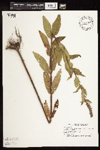 834071[1084375]Smith, Welby R. 197501991-07-19 United States, Minnesota, Todd, Staples State Wildlife Management Area, about 4 mi S of Staples (town); T133N R33W SW1/4 of NE1/4 of Sec 36, 46.2936096 -94.7861099 |
MIN:Plants | 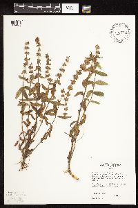 835610[1084488]Monson, Paul H. 45481964-08-19 United States, Minnesota, Becker, R-36, T-142, NE1/4 S-10; about 1/4 mi S of Hwy.113, 2.8 mi W of jnc. with Hwy.71, 46.92837 -95.706909 |
MIN:Plants | 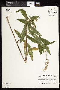 837288[1084374]Smith, Welby R. 176281990-08-01 United States, Minnesota, Morrison, Camp Ripley Miliatary Reservation. About 0.5 km W of Kodiak Road and 1.0 km E of Lake Alexander; UTM: 38500 Camp Ripley Miliatary Reservation. Morrison Co. About 0.5 km W of Kodiak Road and 1.0 km E of Lake Alexander; UTM: 385000E 5117000N T131N R30W NE1/4 of SW1/4 of Sec 32. 131N 30W 32, 46.196859 -94.490469 |
MIN:Plants | 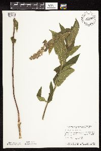 841165[1084407]Smith, Welby R. 133021987-07-02 United States, Minnesota, Dodge, Hythecker Prairie Scientific and Natural Area, about 9 mi SE of Owatonna; SW1/4 SE1/4 sec.31, T107N R18W, 44.0241661 -93.0319443 |
MIN:Plants |  841268[1084400]Smith, Welby R. 14516A1988-07-12 United States, Minnesota, Washington, At the N end of Big Marine Lake, about 5 mi NW of Marine on St. Croix; NW1/4 SE1/4 sec.20, T32N R20W, la. Washington Co. At the N end of Big Marine Lake, about 5 mi NW of Marine on St. Croix; NW1/4 SE1/4 sec.20, T32N R20W,, 45.2425 -92.861111 |
MIN:Plants |  690576[1084530]Siemers, Ross 611977-07-07 United States, Minnesota, Stearns, Great Blue Heron Rookery Area. Near the Sauk River. T123N R30W Sec.13 [Cold Spring Heron Colony Scientific Natural Area], 45.462715 -94.394215 |
MIN:Plants |  511683[1084379]Gerdes, Lynden B. 31141998-08-10 United States, Minnesota, Cook, T65N R02W S19NWSE. Superior National Forest. Shore area of bay in far southeast end of Gunflint Lake., 48.09615 -90.694288 |
MIN:Plants |  906332[1084521]Gerdes, Lynden B. 54682007-07-05 United States, Minnesota, Lake, T60N R09W S26NWSW. Superior National Forest. West Fish Fry Lake area, approx. 5.05 miles NW of Isabella, MN. Dry pond basin ('Slash Pond') 0.15 miles north of West Fish Fry Lake...NAD 83 / 616479 / 5278668, 47.65092 -91.448942 |
MIN:Plants | 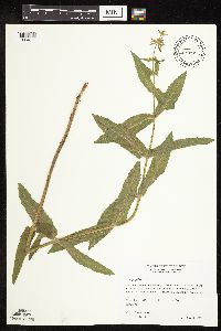 511538[1084378]Wheeler, Gerald A. 163411997-06-28 United States, Minnesota, Swift, Ca. 10 mi. NNE of Kerkhoven; Monson Lake State Memorial Park. Monson Lake. W1/2 NE1/4 NW1/4 T121N R37W Sec 1, 45.326774 -95.241942 |
MIN:Plants | 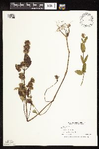 435633[1084385]Nation, Renee G. 94-3611994-09-07 United States, Minnesota, Mower, Lake Louise State Park. Tract 3B; T101N R14W SW1/4 of SW1/4 of Sec. 21, 43.536579 -92.519043 |
MIN:Plants | 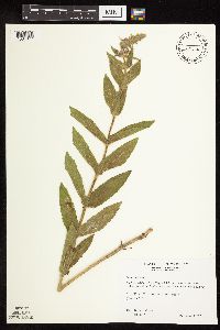 511056[1084377]Wheeler, Gerald A. 164191997-06-30 United States, Minnesota, Chippewa, Ca. 7 mi. WNW of Clara City; wildlife area. E1/2 NE1/4 NE1/4 Sec. 35 T118N R39W (Havelock 35)7) [Gluek Wildlife Management Area], 44.990131 -95.515725 |
MIN:Plants | 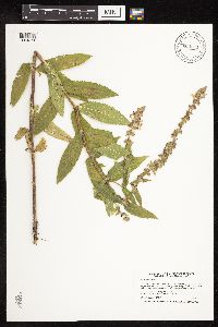 904571[1084371]Smith, Welby R. 257481995-07-18 United States, Minnesota, Rock, Blue Mounds State Park, about 4 miles north-northeast of Luverne...Mound Creek...T103N R45W NW1/4 of NW1/4 of Sec 24, 43.7163889 -96.1897222 |
MIN:Plants |  511226[1084380]Wheeler, Gerald A. 205251999-09-11 United States, Minnesota, Sibley, Ca. 2 mi. SW of Arlington; 1.2 mi. SW of Rte. 9 on Rte. 5. adjacent to railroad tracks. SE1/4 SE1/4 SE1/4 Sec. 18 T113N R27W (Arlington 18), 44.594204 -94.122705 |
MIN:Plants |  435198[1084388]Nation, Renee G. 94-1071994-06-21 United States, Minnesota, Mower, Lake Louise State Park. Tract #13N. T101N R14W NE1/4 of SE1/4 of Sec. 21, 43.53658 -92.51904 |
MIN:Plants |  483917[1084382]Anderson, Craig 5541999-07-20 United States, Minnesota, Grant, T129N R41W: SE 1/4 of NE 1/4 of NE 1/4 of Sect. 25, 45.959807 -95.770875 |
MIN:Plants |  461736[1084384]Schik, Karen G. 95-1771995-08-31 United States, Minnesota, Le Sueur, T111N R26W SW1/4 of the SW1/4 of S22; Minnesota River at Chamberlain Woods Scientific and Natural Area, 44.406165 -93.938571 |
MIN:Plants |  914354[1084370]Smith, Welby R. 225241993-06-22 United States, Minnesota, Stevens, National waterfowl production area, about 4.5 miles south-southwest of Donnelly. SE1/4 of SW1/4 of section [Pepperton Wildlife Management Area?], 45.690516 -96.012556 |
MIN:Plants |  447762[1283206]Lee, Jeffrey 00222013-08-16 United States, Minnesota, Saint Louis, Just W of Elephant Lake and 350 m W of Cty Rd. CR-180. orr is nearest town about 16 km SW. SE1/4 NE1/4 of sec. 22, T66N R19W, 48.1908333 -92.7613889 |
MIN:Plants |  942102[1283200]Smith, Welby R. 319222010-07-28 United States, Minnesota, Beltrami, On the west side of Highway 72, about 10 miles south of Waskish. NE of NW of section;Red Lake State Forest;152N;30W;11, 48.0028794 -94.4540725 |
MIN:Plants |  940673[1283581]Chayka, Katy 13-0282013-07-29 United States, Minnesota, Ramsey, Approx 200 yds north on foot path from south parking lot off CR F for Sucker Lake -- west side of path; T30N, R22W, SW Sec.19, 45.0674 -93.099483 |
MIN:Plants |  956434[1296245]Stork, H. E. s.n.1925-00-00 United States, Minnesota, Itasca |
MIN:Plants |  956433[1296246]Kramer, Leona s.n.1927-00-00 United States, Minnesota, Mower |
MIN:Plants |  956435[1296244]Kaliher, Earl L. s.n.1927-00-00 United States, Minnesota, Todd |
MIN:Plants |  960138[1318469]Stork and Harrington 1930-08-19 United States, Iowa, Along Iowa River |
MIN:Plants | 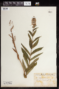 960137[1318470]Friesner, Ray C. 97321936-06-29 United States, Indiana, Marion |
MIN:Plants | 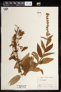 960136[1318471] 1930-08-19 United States, Iowa, Along Iowa River |
MIN:Plants | 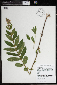 966356[1359196]Timothy J. S. Whitfeld 28352021-07-08 United States, Minnesota, Washington, Lost Valley Prairie Scientific and Natural Area, 2 miles east north east of intersection of State Highway 95 and 110th., 44.797355 -92.825493, 278m |
MIN:Plants | 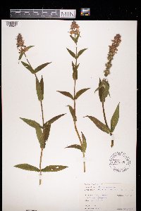 972878[1398431]Janssens, J. 75/1891975-07-22 Belgium, Kanaal Antwerpen - Turnhout, 20m |
MIN:Plants |  974683[1397450]Dunevitz, Hannah L. 4641991-08-08 United States, Minnesota, Goodhue, Floodplain of the Vermillion River, just south of Lower Lake near the area known as Rattling Springs., 44.63 -92.7 |
MIN:Plants |  386935[1080430]Yelich-Koth, C. 0112006-10-05 United States, Minnesota, Ramsey, Ramsey Co, Falcon Heights. Old trolley way, near the UMN St. Paul campus across Cleveland Avenue. Future site of the Bell Museum of Natural History.. 029N 23W 20, 44.990236 -93.188563 |
MIN:Plants |  912715[1080433]Lee, Michael MDL44962007-08-07 United States, Minnesota, Wadena, Wadena County...Along the Leaf River ~two miles downstream from the mouth of the Redeye River, nine miles north-northwest of downtown Staples...T135N R33W NE1/4 of SW1/4 of NW1/4 Sec. 28...UTM: 5149059N 357186E. 135N 33W 28, 46.47547 -94.85101 |
MIN:Plants |  435330[1080419]Boe, J. 970717011997-07-17 United States, Minnesota, Aitkin, Releve 97-15 along Willow River. SE1/4 of NE1/4 of section;;049N;25W;15, 46.7321246 -93.4955917 |
MIN:Plants |  911943[1080432]Smith, Welby 218941992-09-03 United States, Minnesota, Watonwan, Watonwan County...About 5 miles east of St. James...along the South Fork Watonwan River...T 106N R 31W SW1/4 of SE1/4 of Sec 14. 106N 31W 14, 43.9786111 -94.5255556 |
MIN:Plants |  493987[1080429]Gerdes, Lynden 39782000-06-16 United States, Minnesota, Lake, T56N R07W S08SWNWS Lake County ...Tettegouche State Park. Trail sideside, north of MicMac Camp.;North Shore / Tettegouche State Park;056N;07W;08, 47.33958 -91.198054 |
MIN:Plants |  509076[1080465]Kaul, R. 69531991-05-26 United States, Minnesota, Steele, Steele County ... slope above the Straight River, Lemond Road;;107N;20W;, 44.084579 -93.230139 |
MIN:Plants |  509221[1080466]Wheeler, Gerald 195301999-05-12 United States, Minnesota, Pipestone, Split Rock Creek State Park. Pipestone County ... Ca. 1 mi. Sof Ihlen on Rte. 54, E of road; Split Rock Creek State Park. ... W1/2 NW1/4 Sec. 15 T105N R46W (Eden 15). 105N 46W 15, 43.899756 -96.357147 |
MIN:Plants | 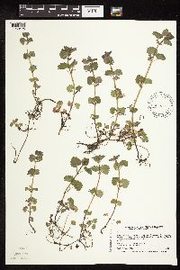 431673[1080425]Smith, Welby 166501990-05-21 United States, Minnesota, Steele, Steele County ... Kaplan Woods City Park, on the south side of Owatonna ... On the north side of the Straight River T107N R20W NE1/4 of NW1/4 of Sec 21. 107N 20W 21, 44.0644455 -93.2350006 |
MIN:Plants | 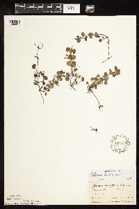 183454[1080501]Ainslie, G. 30951902-05-19 United States, Minnesota, Olmsted, Rochester;;106N;14W;, 43.97834 -92.49834 |
MIN:Plants | 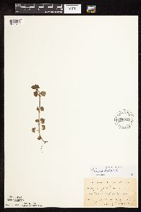 183455[1080488]Kassube, J. s.n.1878-05-00 United States, Minnesota, Hennepin, Minneapolis;;N;;, 44.979965 -93.263836 |
MIN:Plants | 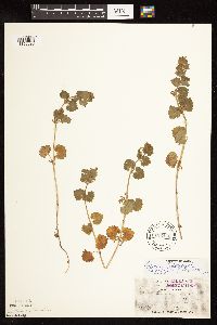 183456[1122895]Holzinger, John s.n.1886-05-00 United States, Minnesota, Winona, Winona Co.;;N;;, 43.98685 -91.779129 |
MIN:Plants | 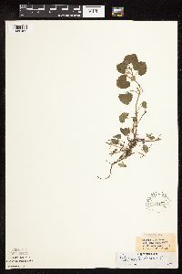 183457[1080489]White, Sidney s.n.1889-05-08 United States, Minnesota, Winona, at Winona;;N;;, 44.0333 -91.6333 |
MIN:Plants | 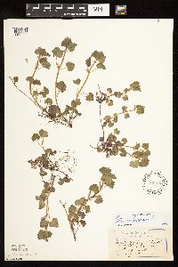 183458[1122896]Sandberg, John s.n.1894-05-00 United States, Minnesota, Goodhue, Red Wing;;N;;, 44.562468 -92.533801 |
MIN:Plants | 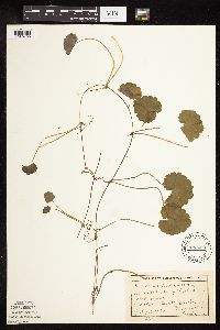 183459[1080499]Lyon, H. 2291899-07-13 United States, Minnesota, Houston, Crooked Creek;Dorer Memorial Hardwood State Forest;N;;, 43.592621 -91.284352 |
MIN:Plants | 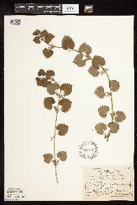 227051[1080500]Roberts, Thomas s.n.1904-07-00 United States, Minnesota, Wabasha, Brook Lodge Flora. Wabasha Co.;;N;;, 44.383856 -92.032945 |
MIN:Plants |  263925[1122897]Holzinger, John s.n.1901-05-00 United States, Minnesota, Winona, Winona Co.;;N;;, 43.98685 -91.779129 |
MIN:Plants |  265375[1080442]Goldsmith, G. G2181912-00-00 United States, Minnesota, Rice, Northfield;;N;;, 44.458298 -93.161604 |
MIN:Plants |  288490[1080498]Johnson, Ruth 371900-05-25 United States, Minnesota, Hennepin, Excelsior;;17N;23W;33, 44.903296 -93.566346 |
MIN:Plants |  289639[1080471]Moyle, J. 7551933-07-05 United States, Minnesota, Clearwater, Itasca Park; Douglas Lodge, SE-NE-24 T143 R36.;Itasca State Park;143N;36W;24, 47.188748 -95.18007 |
MIN:Plants | 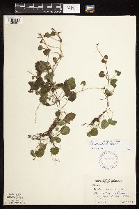 306808[1080497]Moyle, J. 26251935-09-27 United States, Minnesota, Saint Louis, Lake Kabetogama, near Arrowhead Lodge;Voyageurs National Park;N;;, 48.470908 -93.008801 |
MIN:Plants | 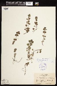 349827[1080479]Lakela, Olga 19581937-06-08 United States, Minnesota, Saint Louis, Forest Hill Cemetery, Duluth;;N;;, 46.7833 -92.1 |
MIN:Plants | 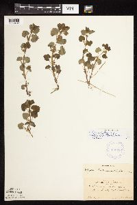 363188[1080492]Beach, W. 511913-05-04 United States, Minnesota, Hennepin, Fort Snelling;Fort Snelling Military Reservation;N;;, 44.870583 -93.209602 |
MIN:Plants | 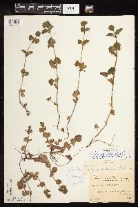 364803[1080476]Gilbert, H. 4701923-06-07 United States, Minnesota, Saint Louis, Duluth;;N;;, 46.7833 -92.1 |
MIN:Plants | 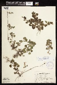 367645[1080480]Moore, John; et al. 124971940-05-18 United States, Minnesota, Fillmore, Fillmore Co. Iowa River floodplain, 1/2 mi E of Granger;;101N;11W;, 43.502188 -92.128791 |
MIN:Plants | 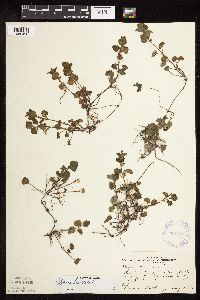 367779[1080490]Moore, John; et al. 124361940-05-17 United States, Minnesota, Mower, Red Cedar River; SW1/4 S.17, Lyle Twp. Mower Co.;;101N;18W;17, 43.547923 -93.013864 |
MIN:Plants | 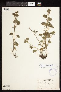 370132[1080496]Moore, John; et al. 141251941-05-25 United States, Minnesota, Carlton, S bank of Moose Horn River, Barnum;;;;, 46.503029 -92.690479 |
MIN:Plants | 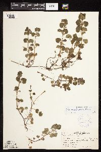 370466[1080493]Moore, John; et al. 139021941-05-11 United States, Minnesota, Fillmore, Fillmore Co. S side of hwy 16, 1 mi SE of Preston;;102N;10W;, 43.659999 -92.069056 |
MIN:Plants |  413735[1080460]Moore, John 106771939-05-13 United States, Minnesota, Goodhue, Belle Creek Valley near Welch;;N;;, 44.550382 -92.724728 |
MIN:Plants |  420796[1080474]Lakela, Olga 101831950-06-03 United States, Minnesota, Saint Louis, Sucker River bridge terrace Pioneer Road;;N;;, 47.0667 -91.8667 |
MIN:Plants |  430743[1080502]Wheeler, Gerald 122761988-09-22 United States, Minnesota, Traverse, Traverse Co.; Ca. 9 mi. NE of Browns Valley, N of Rte. 27; N1/2 Sec. 29 T126N R48W (Windsor Township);;126N;48W;29, 45.695044 -96.72887 |
MIN:Plants |  437232[1080464]Moore, John; Moore, Marjorie 122371939-08-30 United States, Minnesota, Roseau, Growing in the City Park at Warroad;;N;;, 48.905266 -95.314404 |
MIN:Plants |  440920[1080503]Smith, Welby 114691986-05-17 United States, Minnesota, Anoka, Lamprey Pass Wildlife Management Area. Anoka County...Lamprey Pass State Wildlife Management Area, about 2 mi SW of Forest Lake (town)...SW1/4 NE1/4 sec.13, T32N R22W. 032N 22W 13, 45.262649 -93.027734 |
MIN:Plants |  444379[1080417]Nation, R. 94-1201994-06-21 United States, Minnesota, Mower, Lake Louise State Park. Mower Co.; Tract #13N. T101N R14W NE1/4 of SE1/4 of Sec. 21;Lake Louise State Park;101N;14W;21, 43.536579 -92.519043 |
MIN:Plants |  444793[1080441]Moore, John; Huff, N. 193771947-05-23 United States, Minnesota, Chisago, Along the St. Croix River, Interstate State Park at Taylors Falls;Interstate State Park;034N;19W;, 45.394962 -92.668965 |
MIN:Plants |  444904[1080478]Moore, John; Huff, N. 195981947-06-18 United States, Minnesota, Kandiyohi, N of Lake, Sibley State Park.;Sibley State Park;121N;35W;, 45.319687 -95.02307 |
MIN:Plants |  455435[1080450]Smith, Welby 152421989-06-03 United States, Minnesota, Nobles, Nobles County ... About 1.5 miles west of Adrian. East-facing bluff on Kanaranze Creek ... NW1/4 NW1/4 section 14 T 102N R 43W. 102N 43W 14, 43.6433334 -95.9638901 |
MIN:Plants | 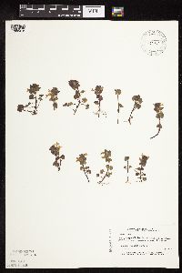 456931[1080418]Myhre, K. 35171993-05-06 United States, Minnesota, Pine, Pine Co.; locatead 6 miles east of Duxbury; T 42N R 16W NW1/4 of NW1/4 of Sec 16;Saint Croix State Forest;042N;16W;16, 46.120466 -92.373149 |
MIN:Plants | 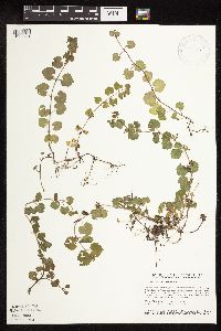 458631[1080451]Smith, Welby 154371989-06-25 United States, Minnesota, Freeborn, Myre Big Island State Park. Freeborn Co.; Helmer Myre State Park, about 2 miles southeast of Albert Lea. On 'Big Island' in Albert Lea Lake; SW1/4 N Freeborn Co.; Helmer Myre State Park, about 2 miles southeast of Albert Lea. On 'Big Island' in Albert Lea Lake; SW1/4 NW1/4 sec.19, T 102N R 20W. 102N 20W 19, 43.625 -93.2874985 |
MIN:Plants |  526293[1080491]Moore, John 210671951-06-26 United States, Minnesota, Todd, Long Prairie River at Long Prairie.;;N;;, 45.975156 -94.866525 |
MIN:Plants | 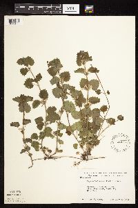 542647[1080453]Moore, John 216731952-06-03 United States, Minnesota, Brown, Sec.17, Eden Twp.;;111N;33W;17, 44.419996 -94.834791 |
MIN:Plants | 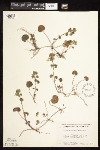 542745[1080469]Moore, John; Moore, Marjorie 214651952-05-11 United States, Minnesota, Isanti, Mrs. A.D. Cornea's Pine Grove, N of Cedar Creek Bog.;Cedar Creek National History Area;034N;23W;, 45.439089 -93.196902 |
Google Map
Google Maps is a web mapping service provided by Google that features a map that users can pan (by dragging the mouse) and zoom (by using the mouse wheel). Collection points are displayed as colored markers that when clicked on, displays the full information for that collection. When multiple species are queried (separated by semi-colons), different colored markers denote each individual species.