University of Minnesota
http://www.umn.edu/
612-625-5000
http://www.umn.edu/
612-625-5000
Minnesota Biodiversity Atlas
Bell Museum
Dataset: MIN-Plants
Taxa: Linaceae
Search Criteria: excluding cultivated/captive occurrences
Bell Museum plants | |
 MIN:Plants | Linum rigidum Pursh 427670[]Smith, Welby R. 117171986-06-12 United States, Minnesota, Pipestone, Prairie Coteau State Scientific and Natural Area (Aetna Prairie); on the northwest side of State Highway 23, about 2.5 mi northeast of Holland. NW1/4 SE1/4 section 32, T 108N R 44W, 44.115278 -96.152222 |
MIN:Plants | Linum rigidum Pursh 306924[]Cottrell, R. G. s.n.1935-07-15 United States, Minnesota, Anoka, Fridley area [T30N,R24W], 45.0809847 -93.2555346 |
MIN:Plants | Linum rigidum Pursh 306960[]Cottrell, R. G. 291935-07-06 United States, Minnesota, Anoka, Fridley region [T30N,R24W], 45.0809847 -93.2555346 |
MIN:Plants | Linum rigidum Pursh 364417[]Moyer, Lycurgus R. 22641907-08-25 United States, Minnesota, Chippewa, Montevideo [T117N,R40W], 44.9346263 -95.6757744 |
MIN:Plants | Linum rigidum Pursh 371337[]Moore, John W. 146431941-07-06 United States, Minnesota, Pope, 1 mi E of Glenwood, 45.653838 -95.291797 |
MIN:Plants | Linum rigidum Pursh 383767[]Moore, John W. 160641943-09-03 United States, Minnesota, Anoka, intersection of hwy 65 with Rice Creek [T30N,R24W], 45.0809847 -93.2555346 |
MIN:Plants | Linum rigidum Pursh 396848[]Stevens, O. A. 10541948-07-24 United States, Minnesota, Clay, Buffalo River State Park [T139N,R46W,S10], 46.8693271 -96.4734276 |
MIN:Plants | Linum rigidum Pursh 453656[]Swanson, Gary s.n.1998-07-30 United States, Minnesota, Sherburne, Sherburne National Wildlife Refuge; SWNE 15-35-27, 45.482148 -93.721671 |
MIN:Plants | Linum rigidum Pursh 550981[]Tucker, Shirley Cotter 3852A1954-08-00 United States, Minnesota, Yellow Medicine, W side of Granite Falls, 44.813124 -95.559651 |
MIN:Plants | Linum rigidum Pursh 554283[]Moore, John W. 229061956-06-13 United States, Minnesota, Clay, 5 mi S of Rollag, 46.667574 -96.238118 |
MIN:Plants | Linum rigidum Pursh 573966[]Stevens, O. A. 24431961-07-02 United States, Minnesota, Norman, Frenchman's Bluff, SE corner [T143N,R43W,S18], 47.2019677 -96.1838932 |
MIN:Plants | Linum rigidum Pursh 585294[]Ownbey, Gerald B. 35551963-07-12 United States, Minnesota, Norman, Frenchman's Bluff, T143N R43W SE1/4 S18, 47.2019677 -96.1838932 |
MIN:Plants | Linum rigidum Pursh 709335[]Wheeler, Gerald A. 43271979-07-10 United States, Minnesota, Lac Qui Parle, Approx. 1 mi E of Nassau on Rte 24, near the junction of Routes 7 and 24. T119N, R46W, S33, 45.0734795 -96.4248474 |
MIN:Plants | Linum rigidum Pursh 741596[]Converse, C. 15311982-07-09 United States, Minnesota, Swift, Chippewa Prairie: T120N, R43W SW1/4 SE1/4 S35, 45.1592579 -96.0107673 |
MIN:Plants | Linum rigidum Pursh 753465[]Duxbury, Alexis 19721983-08-01 United States, Minnesota, Lincoln, Hole-in-the-Mountain Prairie: portions of S1/2 S19; and SW1/4 S20, 44.426573 -96.272705 |
MIN:Plants | Linum rigidum Pursh 759614[]Homme, Virginia H. s.n.1984-06-23 United States, Minnesota, Renville, Hawk Creek Township, S20 [T115N,R38W,S20], 44.7524925 -95.4526091 |
MIN:Plants | Linum rigidum Pursh 789742[]Smith, Welby R. 103801985-06-03 United States, Minnesota, Lac Qui Parle, Yellow Bank Hills, about one mi SSE of Nassau, on the S side of Co Hwy 24. SE1/4 NE1/4 S4, T118N, R46W, 45.0649986 -96.4194412 |
MIN:Plants | Linum rigidum Pursh 269376[]Moore, John W. 10761925-07-00 United States, South Dakota, Custer, Wind Cave [Wind Cave National Park], 43.580095 -103.439479 |
MIN:Plants |  Linum rigidum Pursh 960368[1318882] 1891-00-00 United States, Nebraska |
MIN:Plants |  Linum rigidum Pursh 963573[1352188]Graham, Dustin R. DRJG1102017-08-31 United States, Minnesota, Big Stone, 1.7 miles east of Hanson lake., 45.34 -96.26, 1106m |
MIN:Plants |  Linum rigidum Pursh 966781[1359536]Anderson, Derek S. 27092017-06-21 United States, Minnesota, Polk, Thorson Prairie WMA. About 7.5 km southeast of Harold. About 2.5-3 km east of State Highway 102 on County Road 247., 47.67 -96.41 |
MIN:Plants | 585303[]Moore, John W. 259541962-05-28 United States, Minnesota, Redwood, at Sanborn [109N;36W], 44.2386024 -95.168706 |
MIN:Plants | 671276[]Marth, Verlyn s.n.1976-07-17 United States, Minnesota, Stevens, 200' N of intersection of State 9 and County 9, N.W. of Donnelly, S.W. of road between road & railroad [126N;43W;25], 45.6942019 -96.0164134 |
MIN:Plants |  696697[1397301]Smith, Welby 7861978-06-03 United States, Minnesota, Wright, Wright Co.; T122N, R26W, SW1/4 S27, 45.347676 -93.9422734 |
MIN:Plants | Linum lewisii Pursh 491553[]Williams, M. s.n.1982-00-00 United States, Nevada, Lyon, Sweetwater Mts, Lyon Co. |
MIN:Plants | Linum lewisii Pursh 910953[]Nash, A.; Nash, V. 39771965-07-10 United States, Wyoming, Park, Mammoth;Yellowstone National Park |
MIN:Plants | Linum lewisii Pursh 123711[]Nash, A.; Nash, V. 39781965-07-10 United States, Wyoming, Park, [no further data];Yellowstone National Park |
MIN:Plants | 944775[]Dziuk, Peter M. PMD15-0342015-06-04 United States, Minnesota, Otter Tail, North side Cr 24, 1.21 miles east of Hwy 59 in Erhard. T135N, 43W Sec 22, 46.485261 -96.073553 |
MIN:Plants | Linum lewisii Pursh 283339[]Moore, J. A. 35501931-07-20 United States, Texas, Culberson, Guadalupe Mountains. McKittrick Canyon. [Guadalupe Mountains National Park] |
MIN:Plants | Linum lewisii Pursh 762150[]Kittelson, John M. 1511975-07-04 United States, Utah, Garfield, State highway 63 just outside entrance to Bryce Canyon National Park. Paunsaugunt Plateau. East fork Sevier River drainage., 2362m |
MIN:Plants | Linum lewisii Pursh 492020[]Stevens, O. A. 14421953-07-06 United States, North Dakota, Billings, Medora [Theodore Roosevelt National Park] |
MIN:Plants | 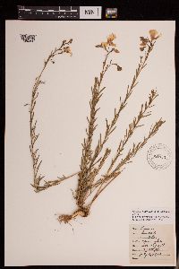 Linum lewisii Pursh 951953[1290350]Lawrence, D. B. 461930-07-02 United States, Colorado, Gunnison, Gothic. Rocky Mountain Biological Station., 2896m |
MIN:Plants | 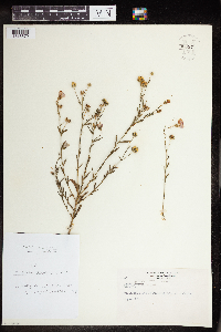 Linum lewisii Pursh 960371[1318879]Rogge, Janet 601954-08-17 United States, South Dakota, collected north of Pickerel Lake on roadside |
MIN:Plants | 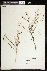 Linum lewisii Pursh 960370[1318880]Rogge, Janet 601954-08-17 United States, South Dakota, collected north of Pickerel Lake on roadside |
MIN:Plants | 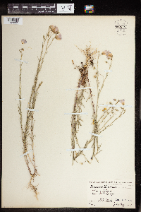 Linum lewisii Pursh 960538[1329083]Stork, H.E. 1927-08-00 United States, Wyoming, Yellowstone National Park, Mammoth Hot Springs |
MIN:Plants |  Linum lewisii Pursh 960965[1334048]Anderson, Derek S. 25422016-05-18 United States, Minnesota, Stevens, Verlyn Marth Memorial Prairie SNA, About 4 km northeast of Donnelly. Just east of the intersection of County Road 9 and County Road 76., 45.75 -96 |
MIN:Plants |  Linum lewisii Pursh 0968689[1391284]F.W. Bieberdorf 1941-00-00 United States, Wyoming, Yellowstone Park |
MIN:Plants |  Linum lewisii Pursh 0968688[1391285]W.D. Manhart 1938-07-00 United States, Wyoming, Yellowstone Park |
MIN:Plants |  Linum lewisii Pursh 828915[1397297]Heidi A. Linnstrom 84-1031984-00-00 United States, Idaho, Butte, Idaho National Engineering Laboratory (U.S.D.O.E.) |
MIN:Plants | 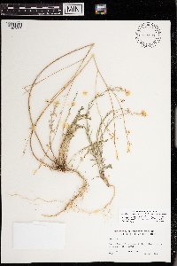 Linum lewisii Pursh 828931[1397298]Heidi A. Linnstrom 83-331983-00-00 United States, Idaho, Butte, Idaho National Engineering Laboratory (U.S.D.O.E.) |
MIN:Plants | Linum lewisii Pursh []Lehl, M. GW13812002-07-29 United States, Colorado, Gunnison, Kebler Pass Road near Marcellina Mountain, Gunnison National Forest, Gunnison County, 38.910056 -107.240528, 2590m |
MIN:Plants | Linum lewisii Pursh []Allen, A. GW25422005-06-29 United States, Colorado, Gunnison, Bracken Creek, Kebler Pass Road, 38.851333 -107.106667, 3024m |
MIN:Plants | Linum sulcatum var. sulcatum Riddell 499029[]Juhnke, Charles M. 433 CMJ FRO1999-07-13 United States, Minnesota, Goodhue, Frontenac State Park. On hill prairie knoll with bench directly north of contact station. T112N 13W SE NW SE 2, 44.5350723 -92.3391578 |
MIN:Plants | Linum sulcatum var. sulcatum Riddell 492577[]Wheeler, Gerald 175361997-09-01 United States, Minnesota, Renville, Renville County ... W side of Morton, Morton Outcrop complex ... SW1/4 NW1/4 NW1/4 Sec. 31 T113N R34W (Birch Cooley 31);;113N;34W;31, 44.5432687 -94.9903271 |
MIN:Plants | Linum sulcatum var. sulcatum Riddell 508957[]Wheeler, Gerald 204521999-08-27 United States, Minnesota, Renville, Renville County ... Ca. 2.7 mi. W of Stewart; 1.7 mi. W of Rte. 20 on Rte. 212, N of road ... E1/2 SE1/4 NW1/4 Sec. 34 T115N R31W (Preston Lake 34). 115N 31W 34, 44.7242666 -94.5487103 |
MIN:Plants | Linum sulcatum var. sulcatum Riddell 459520[]Whitfeld, T.J.S. 2004-08-04 United States, Minnesota, Otter Tail, Otter Tail County ...4 miles northwest of Dunvilla; 1/2 mile south of Otter Tail/Douglas County line ...T137N R43W NWNW3;;137N;43W;03, 46.7107104 -96.1010153 |
MIN:Plants | Linum sulcatum var. sulcatum Riddell 539995[]Tester, John s.n.1957-07-25 United States, Minnesota, Mahnomen, Mahnomen County...Waubun prairie, 3-4 miles w. and 1 mile s. of Waubun. Sect. 33, T. 143N, R. 42W.;Waubun Prairie Wildlife Management Area / White Earth Indian Reservation;143N;42W;33, 47.1589041 -96.0074302 |
MIN:Plants | Linum sulcatum var. sulcatum Riddell 482922[]Anderson, Craig 5381999-07-14 United States, Minnesota, Otter Tail, Ottertail Co.; Glacial Lake Agassiz; T131N R44W: NW1/4 of SE 1/4 of SW1/4 of Sect. 33;;131N;44W;33, 46.11589 -96.2144699 |
MIN:Plants | Linum sulcatum var. sulcatum Riddell 96527[]Wheeler, Gerald A. 174151997-08-29 United States, Minnesota, Renville, Ca 2 mi. WSW of Morton on Rte. 15, N of road. SE1/4 SE1/4 NE1/4 Sec. 26 T113N R35W, 44.5634828 -95.0250514 |
MIN:Plants | Linum sulcatum var. sulcatum Riddell 509032[]Wheeler, Gerald 177741997-09-06 United States, Minnesota, Redwood, Redwood County ... Ca. 6. mi. NNE of Morgan, 0.2 mi. W of Rte. 11 ... SW1/4 SW1/4 SE1/4 Sec. 14 T112N R34W (Sherman 14);;112N;34W;14, 44.5067925 -94.8959453 |
MIN:Plants | Linum sulcatum var. sulcatum Riddell 510305[]Wheeler, Gerald A. 202091999-08-02 United States, Minnesota, Sibley, Ca. 2 mi. SW of Henderson; Rush River State Wayside Park. E1/2 SE1/4 Sec. 15 T112N R26W, 44.50747 -93.93932 |
MIN:Plants | Linum sulcatum var. sulcatum Riddell 264052[]Holzinger, John M. s.n.1888-08-16 United States, Minnesota, Winona, Near Winona, 44.049469 -91.673647 |
MIN:Plants | Linum sulcatum var. sulcatum Riddell 264509[]Holzinger, John s.n.1897-07-00 United States, Minnesota, Winona, Winona Co.;;N;;, 44.056378 -91.671587 |
MIN:Plants | Linum sulcatum var. sulcatum Riddell 278053[]Roberts, Thomas S. s.n.1889-07-00 United States, Minnesota, Hennepin, Minneapolis, 44.97025 -93.265209 |
MIN:Plants | Linum sulcatum var. sulcatum Riddell 354863[]Lakela, Olga 27681938-08-21 United States, Minnesota, Saint Louis, Near Enger's Golf Course at Skyline Parkway, Duluth, 46.768225 -92.110699 |
MIN:Plants | Linum sulcatum var. sulcatum Riddell 360985[]Lakela, Olga 37921940-07-29 United States, Minnesota, Saint Louis, Filled-in area on St. Louis River near the Duluth-Superior Dredging dock, Duluth;;N;;, 46.769166 -92.113445 |
MIN:Plants | Linum sulcatum var. sulcatum Riddell 363920[]Moyer, Lycurgus R. s.n.1906-08-02 United States, Minnesota, Pope, [no further data], 45.58776 -95.429504 |
MIN:Plants | Linum sulcatum var. sulcatum Riddell 364856[]Moyle, J. 30081937-08-26 United States, Minnesota, Lyon, Near Florence;;N;;, 44.237127 -96.053604 |
MIN:Plants | Linum sulcatum var. sulcatum Riddell 367438[]Moore, John; Moore, Marjorie 103001938-08-11 United States, Minnesota, Goodhue, 2 mi. N of Stanton;;N;;, 44.500876 -93.022989 |
MIN:Plants | Linum sulcatum var. sulcatum Riddell 369412[]Moore, John; et al. 146311941-07-06 United States, Minnesota, Pope, 1 mi. E of Glenwood. Pope Co.;;;;, 45.653838 -95.291797 |
MIN:Plants | Linum sulcatum var. sulcatum Riddell 370756[]Moore, John; et al. 133301940-06-27 United States, Minnesota, Redwood, Ca. 7 mi. S of Sacred Heart, Redwood Co.;;114N;37W;, 44.6724501 -95.2994856 |
MIN:Plants | Linum sulcatum var. sulcatum Riddell 370853[]Moore, John 130981940-06-20 United States, Minnesota, Yellow Medicine, S side of Granite Falls;;N;;, 44.800214 -95.538709 |
MIN:Plants | Linum sulcatum var. sulcatum Riddell 372523[]Moore, John 147371941-07-06 United States, Minnesota, Otter Tail, Inspiration Peak;Inspiration Peak Scenic Wayside Park;N;;, 46.136667 -95.575843 |
MIN:Plants | Linum sulcatum var. sulcatum Riddell 383425[]Moore, John 159091943-08-18 United States, Minnesota, Dakota, 2 mi. S of Hwy. 100, on German Road.;;N;;, 44.675881 -93.067101 |
MIN:Plants | Linum sulcatum var. sulcatum Riddell 383651[]Moore, John 160371943-08-25 United States, Minnesota, Winona, Winona Co.; N-facing sand ridge of Gwinn's Bluff.;Great River Bluffs State Park;106N;05W;, 43.9633279 -91.4396202 |
MIN:Plants | Linum sulcatum var. sulcatum Riddell 396845[]Stevens, O. s.n.1947-07-18 United States, Minnesota, Clay, [no further data];Buffalo River State Park;139N;46W;10, 46.8693271 -96.4734276 |
MIN:Plants | Linum sulcatum var. sulcatum Riddell 404618[]Ownbey, Gerald; et al. 12341949-08-28 United States, Minnesota, Polk, Polk County...2 mi. W of Fertile;;;;, 47.53654 -96.319983 |
MIN:Plants | Linum sulcatum var. sulcatum Riddell 412613[]Moore, John; et al. 100491937-07-28 United States, Minnesota, Kandiyohi, 2 mi. W and 6 mi. N of Willmar;;;;, 45.208786 -95.084388 |
MIN:Plants | Linum sulcatum var. sulcatum Riddell 413698[]Moore, John; Moore, Marjorie 101221937-08-30 United States, Minnesota, Grant, On r.r. right-of-way, SW1/4 of the SE1/4 of Sec. 17, Sanford Twp.;;N;;, 45.965137 -95.935562 |
MIN:Plants | Linum sulcatum var. sulcatum Riddell 432971[]Harris, Fred 940801994-07-22 United States, Minnesota, Olmsted, Whitewater WMA; outcrops at top of river valley. SW1/4 of NE1/4 of NW1/4 Sect. 1 T107N R11W, 44.0995588 -92.0892489 |
MIN:Plants | Linum sulcatum var. sulcatum Riddell 441949[]Moore, John; Huff, N. 181581945-08-10 United States, Minnesota, Winona, Winona Co. Garvin Heights State Park;;N;;, 44.034284 -91.651327 |
MIN:Plants | Linum sulcatum var. sulcatum Riddell 442077[]Moore, John; et al. 182251945-09-05 United States, Minnesota, Kittson, Kittson County...1 mi. NW of Halma;;;;, 48.66574 -96.61423 |
MIN:Plants | Linum sulcatum var. sulcatum Riddell 442135[]Moore, John; Huff, N. 190421946-08-16 United States, Minnesota, Stevens, Pomme De Terre State Recreational Reserve;;;;, 45.581153 -95.882175 |
MIN:Plants | Linum sulcatum var. sulcatum Riddell 445050[]Moore, John; et al. 175491945-07-08 United States, Minnesota, Rock, Mounds, 3 mi. N of Luverne.;;;;, 43.71397 -96.211777 |
MIN:Plants | Linum sulcatum var. sulcatum Riddell 445599[]Sather, Nancy s.n.1995-07-01 United States, Minnesota, Mahnomen, Mahnomen County; Santee Prairie SNA; T145 R41 SWNE of Sec 7;Santee Prairie Scientific Natural Area / White Earth Indian Reservation;145N;41W;7, 47.3906158 -95.9224072 |
MIN:Plants | Linum sulcatum var. sulcatum Riddell 447563[]Lee, Michael MDL7521994-07-29 United States, Minnesota, Fillmore, Fillmore Co.; slope along Wadden Valley 4 miles south of Pilot Mound; T 104N R 10W SW1/4 of SW1/4 of Sec 34;Dorer Memorial Hardwood State Forest;104N;10W;34, 43.7675086 -92.0195341 |
MIN:Plants | Linum sulcatum var. sulcatum Riddell 449229[]Moore, John; Hall, Robert 168691944-08-05 United States, Minnesota, Benton, Benton Co. 1 mi. S of Royalton;;038N;32W;, 45.8009107 -94.292895 |
MIN:Plants | Linum sulcatum var. sulcatum Riddell 471793[]Smith, Welby 163511989-08-31 United States, Minnesota, Chisago, Chisago Co. St. Croix Wild River State Park, about 9 mi N-NW of Taylors Falls; SE1/4 NW1/4 sec.17, T35N R19W;Wild River State Park;035N;19W;17, 45.523056 -92.7486115 |
MIN:Plants | Linum sulcatum var. sulcatum Riddell 501168[]Moore, John 204061949-07-06 United States, Minnesota, Grant, 4 mi. E of Elbow Lake;;N;;, 45.993142 -95.876879 |
MIN:Plants | Linum sulcatum var. sulcatum Riddell 501540[]Stevens, O. s.n.1954-09-15 United States, Minnesota, Pipestone, Pipestone National Monument;Pipestone National Monument;106N;46W;, 43.9797232 -96.367859 |
MIN:Plants | Linum sulcatum var. sulcatum Riddell 53384[]Whitney, Myrtie 211888-08-02 United States, Minnesota, Nicollet, Near St. Peter [T110N,R26W], 44.3264239 -93.9490786 |
MIN:Plants | Linum sulcatum var. sulcatum Riddell 542396[]Moore, John 213431951-08-10 United States, Minnesota, Grant, 3 mi. E of Elbo Lake;;N;;, 45.992455 -95.901058 |
MIN:Plants | Linum sulcatum var. sulcatum Riddell 542455[]Moore, John 218331954-07-20 United States, Minnesota, Wilkin, 2 1/2 mi. S of Breckenridge;;N;;, 46.218111 -96.578516 |
MIN:Plants | Linum sulcatum var. sulcatum Riddell 550211[]Moore, John; et al. 222191954-09-21 United States, Minnesota, Pipestone, Pipestone County...1/2 mi. north of Pipestone;;106N;46W;01, 44.0158476 -96.3176691 |
MIN:Plants | Linum sulcatum var. sulcatum Riddell 574565[]Moore, John 246451959-06-18 United States, Minnesota, Pipestone, Pipestone Co.; 1 1/2 mi. north of Pipestone;;107N;46W;, 44.0669035 -96.3679556 |
MIN:Plants | Linum sulcatum var. sulcatum Riddell 574680[]Moore, John 247671959-07-31 United States, Minnesota, Kittson, At old sand pit, 1 mi. N of Halma.;;N;;, 48.678735 -96.598948 |
MIN:Plants | Linum sulcatum var. sulcatum Riddell 576157[]Cotter Tucker, Shirley 42881958-07-20 United States, Minnesota, Yellow Medicine, Granite Falls;;N;;, 44.808984 -95.556561 |
MIN:Plants | Linum sulcatum var. sulcatum Riddell 602137[]Westkaemper, Remberta s.n.1962-07-01 United States, Minnesota, Stearns, Stearns Co. Along r.r. track. St. Joseph.;;124N;29W;, 45.543642 -94.322053 |
MIN:Plants | Linum sulcatum var. sulcatum Riddell 615954[]Ownbey, Gerald 43211969-08-15 United States, Minnesota, Mahnomen, Mahnomen Co. Two Oaks Prairie near Waubun; NE1/4 Sec. 33, T143N, R41W.;White Earth Indian Reservation;143N;41W;33, 47.1577036 -95.8789541 |
MIN:Plants | Linum sulcatum var. sulcatum Riddell 622402[]Rohrer, Clinton 2091971-08-07 United States, Minnesota, Pipestone, Pipestone Co.; 0.5 mi. west, 0.5 mi. north of Jasper, at old Jasper quarry.;;105N;46W;, 43.8926176 -96.3674534 |
MIN:Plants | Linum sulcatum var. sulcatum Riddell 627709[]Ownbey, Gerald 45941972-07-12 United States, Minnesota, Scott, Scott Co. Shakoppe Prairie, ca. 4 mi. S of Shakopee, W side of Rte. 169. NE1/4 NW1/4 Sec. 28, T115N, R23W.;;115N;23W;28, 44.7402167 -93.5923657 |
MIN:Plants | Linum sulcatum var. sulcatum Riddell 670671[]Heitlinger, M. 3241971-07-20 United States, Minnesota, McLeod, Schaefer Prairie: SE1/4 Sec. 34, T115N, R29W. Along N-S ridge, ca. 250 m S of N boundary.;Schaefer Prairie, The Nature Conservancy;115N;29W;34, 44.7250496 -94.3049103 |
MIN:Plants | Linum sulcatum var. sulcatum Riddell 685162[]Stassen, Carol 2411977-07-30 United States, Minnesota, Lyon, Camden State Park. SW of Lake Brawner. T110N, R42W, Sec. 17.;Camden State Park;110N;42W;17, 44.333919 -95.9272366 |
MIN:Plants | Linum sulcatum var. sulcatum Riddell 689882[]Ownbey, Gerald 57731977-08-05 United States, Minnesota, Polk, T150N, R40W, Sec. 25, SE1/4. S of Rte. 92. Prairie just W of trail.;;150N;40W;25, 47.7832925 -95.7194009 |
MIN:Plants | Linum sulcatum var. sulcatum Riddell 693880[]Roefer, Florence s.n.1978-08-29 United States, Minnesota, Cottonwood, Jeffers Petroglyph Historic Site. T107N, R35W, NW1/4 Sec. 9, Delton Twp.;Jeffers Petroglyphs Historical Site;107N;35W;9, 44.0864517 -95.0499662 |
MIN:Plants | Linum sulcatum var. sulcatum Riddell 696765[]Smith, Welby 7851978-08-06 United States, Minnesota, Wright, Wright Co.; T121N, R25W, NE1/4 Sec. 4. About 1 mi. NW of Monticello. Burlington Northern right-of-way.;;121N;25W;4, 45.323841 -93.838053 |
MIN:Plants | Linum sulcatum var. sulcatum Riddell 700511[]Ownbey, Gerald 61581978-08-15 United States, Minnesota, Houston, Houston Co. T102N, R5W, NW1/4 Sec. 22, Mayville Twp. At the jct. of Rte. 249 and Rte. 32.;Dorer Memorial Hardwood State Forest;102N;05W;22, 43.6232853 -91.4223316 |
MIN:Plants | Linum sulcatum var. sulcatum Riddell 700621[]Ownbey, Gerald 61381978-08-14 United States, Minnesota, Houston, Houston Co. T104N, R5W, W1/2 Sec. 34. Rte. 16 3.7 mi. W of cemetery, W side of Hokah.;;104N;05W;34, 43.7677422 -91.4228103 |
MIN:Plants | Linum sulcatum var. sulcatum Riddell 701078[]Dorio, J. 3721977-06-27 United States, Minnesota, Morrison, Ripley Esker, ca. 3 mi. NE of Camp Ripley Jct. T42N, R31W, Sec. 19.;Ripley Esker Scientific Natural Area;042N;31W;19, 46.1352444 -94.2618383 |
MIN:Plants | Linum sulcatum var. sulcatum Riddell 701367[]Dorio, J. 4641977-07-07 United States, Minnesota, Morrison, Co.: Morrison ... Sandhill Crane Meadow, 4.5 mi. W of Buckman on Hwy 34. T39N, R31W, Sec. 3 & 4.;Crane Meadows National Wildlife Refuge;039N;31W;, 45.8675303 -94.1989191 |
Google Map
Google Maps is a web mapping service provided by Google that features a map that users can pan (by dragging the mouse) and zoom (by using the mouse wheel). Collection points are displayed as colored markers that when clicked on, displays the full information for that collection. When multiple species are queried (separated by semi-colons), different colored markers denote each individual species.