University of Minnesota
http://www.umn.edu/
612-625-5000
http://www.umn.edu/
612-625-5000
Minnesota Biodiversity Atlas
Bell Museum
Dataset: MIN-Plants
Taxa: Loranthaceae
Search Criteria: excluding cultivated/captive occurrences
1
Page 1, records 1-18 of 18
Bell Museum plants | |
 MIN:Plants | 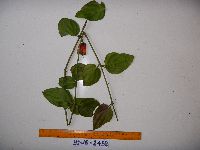 951511[1299320]Weiblen, G.D. YS1G24582010-11-22 Papua New Guinea, Morobe, Yawan Village, -6.1631 146.840217, 1752m |
MIN:Plants | 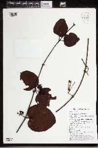 951512[1299319]Weiblen, G.D. YS1J33312012-06-19 Papua New Guinea, Morobe, Yawan Village, -6.164683 146.841717, 1855m |
MIN:Plants | 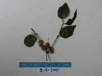 951517[1299314]Weiblen, G.D. YS1G2445 Papua New Guinea, Morobe, Yawan Village, -6.1631 146.840217, 1752m |
MIN:Plants | 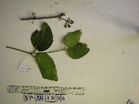 951646[1299241]Weiblen, G.D. YS3H38962012-09-19 Papua New Guinea, Morobe, Yawan Village, -6.1641 146.843567, 1851m |
MIN:Plants | 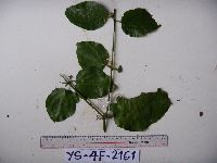 951648[1299239]Weiblen, G.D. YS4F21612010-09-02 Papua New Guinea, Morobe, Yawan Village, -6.16255 146.839933, 1721m |
MIN:Plants | 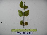 951671[1299216]Weiblen, G.D. YS4F21712010-09-07 Papua New Guinea, Morobe, Yawan Village, -6.16255 146.839933, 1721m |
MIN:Plants |  553029[1369979]Sidey, James L. 32061957-07-00 South Africa, Collected Umhlanda Rocks, Natal |
MIN:Plants | Amyema NULL 939842[]Takeuchi, Wayne 69051990-09-11 Papua New Guinea, East Sepik Province; April river, Samsai ridge above the last Bugabugi camp;;;;, -4.566667 142.566667 |
MIN:Plants |  Viscum salicornioides A. Cunningham 100474[1299063]Heller, A. 21941895-07-23 United States, Hawaii, Kauai, Island of Kauai, on the ridge opposite Gay & Robinson's Hanapepe Valley House |
MIN:Plants | Loranthus falcatus L. f. 540221[]Sethi, K. 671957-01-05 India, [Delhi] University camp |
MIN:Plants | Amyema finisterrae (Warb.) Dans. 939821[]Takeuchi, Wayne 74041991-08-15 Papua New Guinea, near the Markham river;;;;, -6.75 147 |
MIN:Plants | 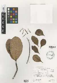 Loranthus raiateensis John W. Moore 620385[1001654]Moore, J.W. 5261927-01-13 French Polynesia, Society Islands, Raiatea, Upper end of 3rd valley south of Faaroa Bay, -16.82666 -151.439587, 140m |
MIN:Plants | 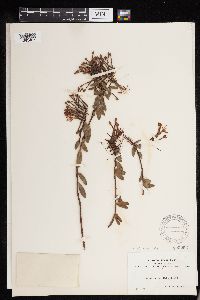 Loranthus verticillatus Ruiz & Pav. 100253[1293487]Bang, Miguel 1391889-00-00 Bolivia, Vicinity of La Paz, 3048m |
MIN:Plants | 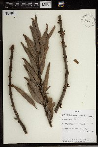 492294[1369981]Lovett, J. 43491990-03-09 Tanzania, United Republic of, Mbeya: Mbeya District Beside Mchewe/Mshewe River, -8.833333 33.333333, 1200m |
MIN:Plants | 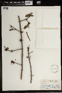 Loranthus natalitius Meisn. 569766[1369980]James L. Sidey 35481961-12-00 South Africa, Natal, Umkomaas Valley |
MIN:Plants |  Viscum hildebrandtii Engl. 578000[1369998]Troupin, G 116401959-03-31 Rwanda, Region du Mutara, 1400 - 1450m |
MIN:Plants |  Englerina heckmanniana (Engl.) Polhill & Wiens 508143[1369978]Lovett, J 30011988-01-31 Tanzania, United Republic of, On Iringa to Dodoma road north of Isimani, -7.666667 35.833333, 1250m |
MIN:Plants |  596659[1299477]McCartney, William s.n.1966-05-04 United States, California, Sonoma, residential property, northwest corner of Mill Station Road and Gravestein North Highway, Sebastopol, Sonoma County |
1
Page 1, records 1-18 of 18
Google Map
Google Maps is a web mapping service provided by Google that features a map that users can pan (by dragging the mouse) and zoom (by using the mouse wheel). Collection points are displayed as colored markers that when clicked on, displays the full information for that collection. When multiple species are queried (separated by semi-colons), different colored markers denote each individual species.